Daily insights for city builders, delivered every morning at 6 AM ET. I’m Brandon Donnelly — a Toronto-based real estate developer and founder of Globizen. I’ve been writing here since 2013.

Tag: topoli

  • It’s not too late for the Gardiner Expressway East

    Boy, time sure does melt away when you’re writing a daily blog and trying to build buildings. It’s hard to believe that it has already been 7-8 years since I was writing incessantly about the merits of Toronto removing the eastern portion of its elevated Gardiner Expressway.

    For those of you who may not be familiar, Toronto has an elevated highway that runs along the waterfront. It is old. Pieces sometimes fall off. Lots of water will drip on you. And so remediation works are underway. Several years ago, there was also a great debate that took place in the city about what should happen with its eastern leg. I even spoke at a Jane’s Walk where I was, for the most part, not very popular.

    The two options under consideration ended up being: 1) remove it and replace it with a grand surface boulevard or 2) remove it and rebuild it with a slightly different alignment. This second option was dubbed the “hybrid” option, but that was mostly political speak so that it sounded like some sort of generous compromise. You can think of it as the more expensive rebuild option.

    City Council voted on these two options as one would expect. Councillors in the core of the city did not want an elevated highway running through their neighorhoods, and the Councillors and people in the inner suburbs — who might use it for commuting — were by and large more accommodating. Apparently there are somewhere around 15,000 commuters who use it each rush hour.

    But here’s the thing.

    This vote took place in June 2015 and the thing still hasn’t yet been rebuilt. So maybe it’s not too late! Maybe there’s an opportunity to save a few hundred million dollars between us friends. Also, if anyone is interested, I’m still available for controversial Jane’s Walk presentations. One new idea I have is an elevated highway that runs through the inner suburbs and connects the best weekend brunch spots.

  • Toronto’s downtown streets broke over the weekend

    Canada Day weekend was a lot of fun in Toronto. This city was alive and it felt like people had come far and wide to visit downtown. But it was a good reminder that even if all of our cars were electric and even if they were all able to drive themselves, we would still have this problem:

    I was in an Uber on Saturday afternoon heading over to the west side of downtown and we had no choice but to declare bankruptcy and hop out in the middle of Bay Street. We thought about waiting for the Ontario Line to be ready, but that seemed a bit far out.

    So we rented bikes instead and rode along the waterfront, which was a considerably better experience. But then we couldn’t find any docks with available slots, so we had to ride up into Liberty Village, drop our bikes off there, and then walk back down to Ontario Place.

    Of course, this was still the better option. I’m fairly certain that we’d still be in that Uber had we stuck it out. And maybe not finding a bike dock is just part of life in the big city on a beautiful long weekend in the summer.

    Still, it was frustrating. So I’ll use this opportunity to once again ask our city leaders to reconsider their ban on dockless electric scooters. Toronto clearly needs all the mobility support it can get.

  • Toronto breaks ground on new Ontario Line

    This past weekend it was announced that ground has been broken (i.e. construction has started) on the new Ontario subway line that will connect Exhibition / Ontario Place to the Science Centre by way of the light purple line labeled “C” on the above map. (The other image is a rendering of the proposed Exhibition station.)

    This transit line has gone through many permutations over the years and was previously called the Downtown Relief Line (but that was seen as too downtown-centric); the Yonge Relief Line (still too specific); the Relief Line (not Ontario-specific enough, I guess); and probably a bunch of other names corresponding to various lines on a map.

    So it is exceedingly easy to be cynical when you hear of an announcement like this. Is it really happening? Are we actually building new and much-needed transit? And as you might imagine, if you read through the chatter on Twitter, you will find an overabundance of this sort of cynicism, along with what appears to be a general dissatisfaction with the current state of everything.

    But in my simple view, I reckon that it is far better to be starting construction on an important new transit line than not starting construction on an important new transit line. So this is exciting! Let’s go! If you’d like to learn more, I also tweeted out the initial renderings for the 14 stations that are planned for the Ontario Line.

    Images: Province of Ontario

  • Should rooming houses be allowed across the city?

    One of the debates I came across on Twitter this week was about multi-tenant houses (also known as rooming houses) in Toronto. Currently, they are allowed in the former city of Toronto, parts of Etobicoke, and in York. But they are illegal everywhere else in the city.

    The reason why the rules differ is simply because they weren’t harmonized following amalgamation in 1998. And so right now we are debating whether or not things should be changed so that multi-tenant houses are permissible across the city.

    As you can probably guess, it’s a divisive issue.

    The more urban councillors believe that rooming houses are vital because of their relative affordability. The more suburban councillors are, on the other hand, speaking for their constituents and saying that homeowners really don’t want them in their communities. It’s about “protecting the integrity of single-family communities.”

    No surprise here.

    For this reason, a recent vote on the issue was deferred. It’s expected to come back to council in September. Maybe there will be more support at that time. Or maybe there won’t be. Either way, rooming houses will continue to exist all across the city. Some of them may just be illegal.

    If I had any say in the matter, I would vote “yes.”

  • The King Street Transit Pilot has started

    Back in January 2016, I wrote about Toronto’s ambition to transform King into a “transit first” street across the downtown core. 

    The King streetcar is the busiest surface transit route in the entire city (65,000 riders / day on average) and it was – and continues to be – my opinion that the route was broken. Something had to be done.

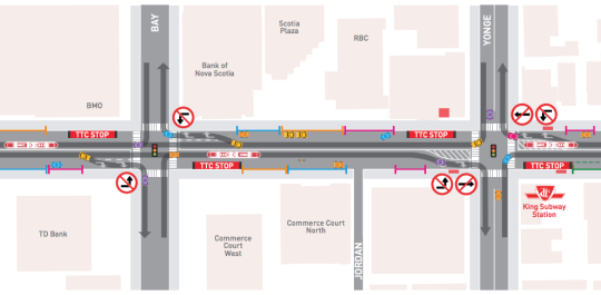
    Well, that something is now happening. The “King Street Transit Pilot” officially started on Sunday, November 12, 2017 at 7am. Here are some of the key changes, many of which are also depicted in the above image:

    – No more on-street parking in the pilot area.

    – Cars can no longer turn left or drive through the intersections of the pilot area (except for taxis picking up drunk people from 10pm to 5am).

    – Cars must now follow a right-in/right-out approach. They can turn right onto King, but then they have to turn right off of King at the next intersection.

    – Most of the streetcar stops have been moved to the “far side” of each intersection. That is, after the lights. Passenger waiting areas are now in the curbside lane and protected by jersey barriers.

    – Cyclists can go through the intersections of the pilot area. “Bike boxes” have been added to intersections where there are north-south bike lanes to help with turning left.

    As to be expected, some people are upset about the above changes. There are also concerns that drivers aren’t going to obey the rules and continue to drive through the intersections in the streetcar lane. But this is a pilot project. It’s about learning and adjusting.

    It’s also important to keep in mind that King has at least 3x more transit riders than cars. This pilot is about figuring out how to best optimize the street so that it moves the greatest number of people as efficiently as possible.

    I’ll report back here on the blog once the pilot has settled in and there is a better understanding of its impact.

  • Politics and bike lanes

    image

    Recently a good friend of mine told me that I had conflicting views in the world of politics.

    She more or less said to me: I know you’re a real estate developer and obviously a capitalist (read: right of center), but you also support what are often considered to be left of center issues. Issues like tearing down the Gardiner Expressway and building more bike lanes.

    I thought this was an interesting comment because, regardless of whether or not you agree with the categorization she was making, the unfortunate reality is that sometimes (oftentimes?) city building issues do become about left vs. right. Bike vs. cars. Urban vs. suburban. And the list goes on.

    My response to her was that I don’t care about what side of the political spectrum an issue supposedly falls on. That’s a distraction. When I think about something, I try and apply rationale thought and facts to the best that I can. 

    For instance, in the case of bike lanes, I have asked myself: would cities be better off if we had more, or less, people cycling? Simple question. And when I think about this and look at some of the numbers, I see a lot of benefits (this is a non-exhaustive list):

    – More people cycling means we’re moving people more efficiently, which you could argue improves urban productivity and overall quality of life. 

    – More people cycling means we will naturally start prioritizing more compact types of urban form, which in itself has a myriad of socioeconomic benefits. 

    – More people cycling means we’re actually taking action to try and fight climate change.

    – And more people cycling means we’re improving health outcomes. Given that public spending on health care is one of the largest government expenditures in OECD countries, I bet you could find measurable financial savings.

    With all of this, I am not naively suggesting that all cars should disappear from our cities and that everyone should only cycle. I think electric vehicles and self-driving vehicles are going to be an important part of the mobility equation in the future. But I am saying that more, not less, cycling strikes me as an obviously positive thing for our cities. 

    On that note…

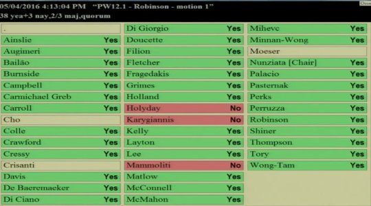
    Toronto City Council voted today in favor (38-3) of a pilot project that will bring separated bike lanes to Bloor Street. The image at the top of this post is how each Councillor voted. So today, we appear to have not fallen into the divide that my friend was talking about. And that makes me, as well as many others, quite happy.

    //platform.twitter.com/widgets.js

    I would be curious how all of you feel about this particular issue. And I would also be curious if you find yourself being more issued based rather than aligned across the political spectrum. That’s certainly how I feel these days.

    I bet we could have a great discussion on this topic in the comment section below 🙂

  • Those troublemakers

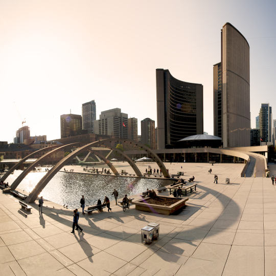
    Toronto City Hall by Sébastien Pacaud on 500px.com

    https://500px.com/embed.js

    Jennifer Keesmaat is the Chief Planner of Toronto. She was hired for this job in 2012.

    She has a Masters in Environmental Studies (Politics and Planning). She is a Registered Professional Planner with the Canadian Institute of Planners. And she was also the founder of 2 (city) planning firms prior to taking the position of Chief Planner for Toronto.

    So presumably, she was hired for this job because she possesses some sort of expertise in the realm of planning. I also presume that she is expected to make her opinions known to other people so that informed planning discussions can occur and decisions can be made.

    So I find it curious that in some circles, and in the media, Jennifer Keesmaat is being branded as a “troublemaker.”

    A lot of the recent chatter stems from the fact that Keesmaat was at odds with Mayor Tory during the Gardiner Expressway East debate (quote via Toronto Life):

    Eventually Tory had enough and pulled Keesmaat into a meeting where he basically told her to zip it. “The mayor has said it is perfectly appropriate for staff to make their opinions public, as Ms. Keesmaat has done,” wrote his communications chief, Amanda Galbraith, in a statement. “It is not appropriate for city staff to campaign against councillors or the mayor on social media or through other public platforms.” Keesmaat counters that she never campaigned. “I stated an opinion,” she says simply.

    But the “troublemaking” didn’t just start with the Gardiner East. Pretty much since the moment she took the position of Chief Planner and launched her own blog (ownyourcity.ca), she was dubbed a shit disturber. (Those bloggers!)

    But if you ask me, these criticisms stem from an old and outdated way of thinking.

    The last thing we need from government is less transparency and more politicking. We should be working towards more, not less, information. Even if that information doesn’t butter our metaphorical bread.

    What do you think?

    I think this will make for a great discussion in the comment section below.

  • What do you think of 1 Bloor West? [Poll]

    image

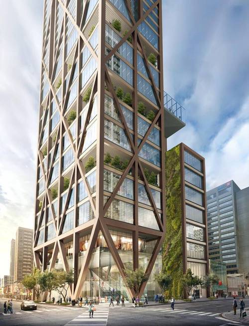
    Over the past few weeks I’ve been running a little experiment on Twitter where I tweet about a new development project in Toronto and I ask people to vote on it. If they like the project, I ask that they retweet (RT) it. And if they don’t like it, I ask that they favorite it (FAV).

    Here’s what it looks like in tweet form:

    As you can see from this experiment, about 69% of the people who participated seemed to be in favor of this project (at least at the time of writing this post). That said, the discussion following this tweet was a lot more negative than I would have expected.

    Somebody also pointed out that in my experiment I’ve created a bias towards supporting the project, since a retweet means the project gets shared, whereas a favorite doesn’t do that. I would argue that the more distribution the better for an accurate consensus, but point taken.

    So today I thought I would do this same experiment here on Architect This City. 

    At the bottom of this post, I’ve featured a comment from myself asking if you support the 1 Bloor West project. If you like the project, I ask that you “up vote” my comment. And if you dislike the project, I ask that you “down vote” it. You can do so by using the up and down arrows towards the bottom left of the comment.

    Hopefully this hack will create a more neutral voting framework. I hope you will participate. If you’re reading this via email, you’ll need to open up the post in your browser by clicking “read more” at the bottom.

    If you’d like to learn more about the project before voting, check out this article from the Globe and Mail. Happy voting!

  • How I moved over the last 3 weeks

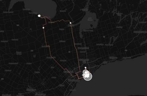
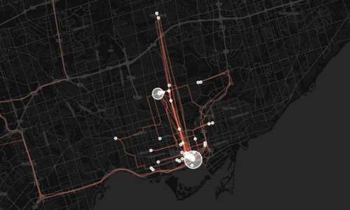
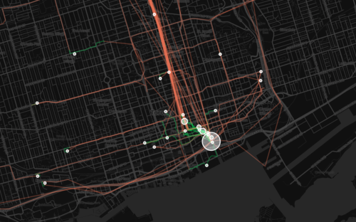
    At the beginning of this year I wrote a post about a mobile tracking app called Moves that I had heard about through my friend Sachin Monga. He had just published a beautiful set maps showing where he physically spent his time in both Toronto and San Francisco.

    His post spurred me to download the app and at the end of my post I promised to share my own set of maps once I had collected enough data points. It’s only been about 3 weeks, but already my maps are starting to fill out, so I thought I would do a release.

    The orange lines represent transport of some sort (car, subway, streetcar, and so on) and the green lines represent walking. I don’t cycle very often in the winter (I know, I’m a fair-weather cyclist), so you won’t see any of those lines just yet. However if I posted a map from the summer, I know it would look completely different.

    Here’s a first one showing a regional scale:

    image

    Here’s a second one showing the city of Toronto:

    image

    And here’s a third one showing mostly downtown:

    image

    What’s interesting about these maps is how much you can tell about me and the way I move around the city.

    For one, there’s a good chance I ski or snowboard given that I’m driving up to Collingwood, Ontario in the winter. You can also see how heavily dependent I am on the Yonge subway line, which is the thickest orange line in the middle of downtown. It’s also interesting to see how localized I am within my neighborhood (St. Lawrence Market). I walk to get groceries. I walk to the gym. I walk to coffee. And the list goes on.

    This is fairly typical for people living in urban neighborhoods, but it would be interesting to see where it applies in the city and where it begins to fall apart. I would also imagine that there’s a correlation to the area’s Walk Score, although this (Moves) might actually be a better measure since it’s usage data.

    Either way, imagine what cities could do if they had this sort of data for every resident. They would be able to see precise resident flows and then determine exactly where transit and infrastructure investments should be made instead of politicking to determine where they should be made.

    That time is coming.

  • How Toronto voted

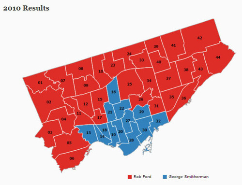
    In 2010, Toronto voted for its new mayor, Rob Ford, like so:

    image

    It was basically the core of the city (old Toronto) versus all of the boroughs. And it was perfect ammunition for anyone who believed that Toronto’s amalgamation was a mistake. (I personally don’t think it was.)

    Yesterday, Toronto did better.

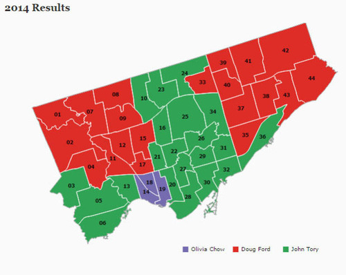
    While we’re still a divided city — with Etobicoke and Scarborough largely remaining loyal to Ford Nation — we’re not quite as divided as we were 4 years ago:

    image

    However, there is one thing that Torontonians did largely agree on last night: the next mayor should be white and male. And this got the Guardian Cities out of the UK asking why one of the most multicultural cities on the planet (apparently we’re third behind Luxembourg City and Dubai), continues to elect middle-aged white guys.

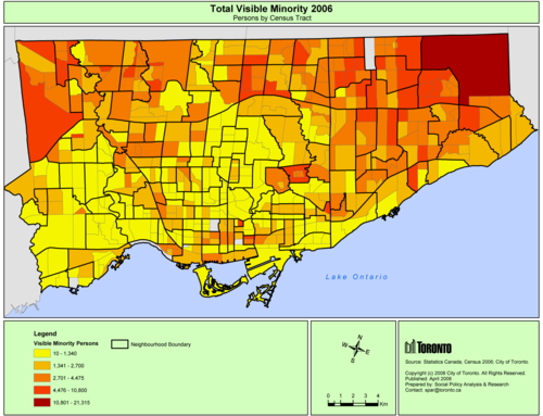
    Now, I’m not a fan of the article. And I take offence to the way Toronto is portrayed. But it did get me thinking. And I thought it would be interesting to see how some of Toronto’s demographic data overlays on top of these election maps.

    Looking at 2006 census data (2011 isn’t available in map form yet), here is a map showing the total number of visible minorities broken down by census tract. The darker the red the more visible minorities.

    image

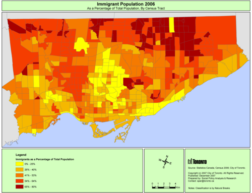
    And here is a map showing immigrants as a percentage of the population. Again, the darker the red, the higher the percentage.

    image

    What should be apparent from these maps is that Ford Nation is actually, in some ways, immigrant and visible minority nation. In the above map, the darkest red areas indicate that immigrants represent anywhere from 65-80% of the population. That’s a significant number.

    So why didn’t this group vote for the Hong Kong-born Olivia Chow? It’s because she wasn’t telling them the right story. Rob and Doug Ford, on the other hand, were.