Daily insights for city builders, delivered every morning at 6 AM ET. I’m Brandon Donnelly — a Toronto-based real estate developer and founder of Globizen. I’ve been writing here since 2013.
By some measurements, cement production alone is responsible for about 8% of human-caused carbon dioxide emissions every year. And so there is an imperative to find suitable low-carbon alternatives. Here is what is currently happening in the US (via Grist):
On Tuesday, Terra CO2 Technology was picked to receive a $52.6 million federal grant to build a new manufacturing plant just west of Salt Lake City. The company has devised a method that turns common minerals into additives that can help replace Portland cement — a key component in concrete, and one of the most carbon-intensive materials in the world.
In addition to this new facility, the company is set to start construction on its first plant in the Dallas-Fort Worth area:
The project is expected to break ground in January 2025 and begin shipping out materials by late summer 2026, Yearsley said. The facility will be capable of producing up to 240,000 metric tons of SCM [supplementary cementitious materials] per year when completed, or enough to serve roughly half of the local metropolitan market.
And all of this is part of a broader initiative by the US Department of Energy:
The Utah facility is one of 14 projects provisionally selected this week to receive $428 million in total awards from the U.S. Department of Energy’s Office of Manufacturing and Energy Supply Chains. The initiative, which is funded by the Bipartisan Infrastructure Law, aims to accelerate clean energy manufacturing in U.S. communities with decommissioned coal facilities. Officials said the projects are expected to create over 1,900 high-quality jobs across a dozen states.
Prices continued to rise in most luxury ski towns this past year, but none grew as much as Park City, a former silver mining town 32 miles east of Salt Lake City. The average home sale price there grew 35% in 2023 from 2022, compared with a 9.4% increase at Vail and Beaver Creek and 3.2% at Aspen, according to the resort report by Summit Sotheby’s International Realty.
The main point of the article is this: Park City has gotten really expensive, and so people are now looking and buying homes further out in places like Heber City, Midway, and Kamas. Here’s how expensive expensive is:
Over the last four years, Covid has stoked demand for western resort real estate. In Park City, single-family homes have sold for a median price of $4 million year-to-date, up from $1.996 million in 2019, according to Redfin, which averaged the monthly median sales prices weighted for the number of homes sold. One home was listed in September for $65 million, which could set a record for the state. It’s now under contract, according to listing agent Paul Benson of Engel & Völkers, who declined to disclose the sale price.
This, of course, isn’t a novel phenomenon. It’s the whole “drive until you qualify” thing. But what’s interesting about this particular mountain example is that it’s not centered around access to a CBD or downtown; it’s centered around “how fast can I get to a ski and snowboard resort?”
For example, Deer Valley has a new East Village that is expected to open up in 2025. This brings the cities mentioned above closer in. And buyers seem to be doing that math: “It’s a 25-minute drive today, but next year I’ll be able to get on a lift in 15 minutes. Score.”
Given that Deer Valley also doesn’t allow snowboarders, it’s interesting to think about how these trends could be bifurcating the region between skiers and snowboarders. I don’t have any data on this, but I bet if you mapped it out, there would be some sort of clustering happen.
The article also goes on to talk about transportation. Because you can’t talk about new development and real estate without talking about traffic. But I think Bill Ciraco (Park City Council) gets it exactly right in the article: This is a car problem, and less of a people problem.
In my mind, the Wasatch Range is destined for something like this ONE Wasatch concept, which is/was a proposal to link seven resorts through a handful of new skiable connections. This is similar to what you’ll find in Europe, and it means less driving and more time on the mountain.
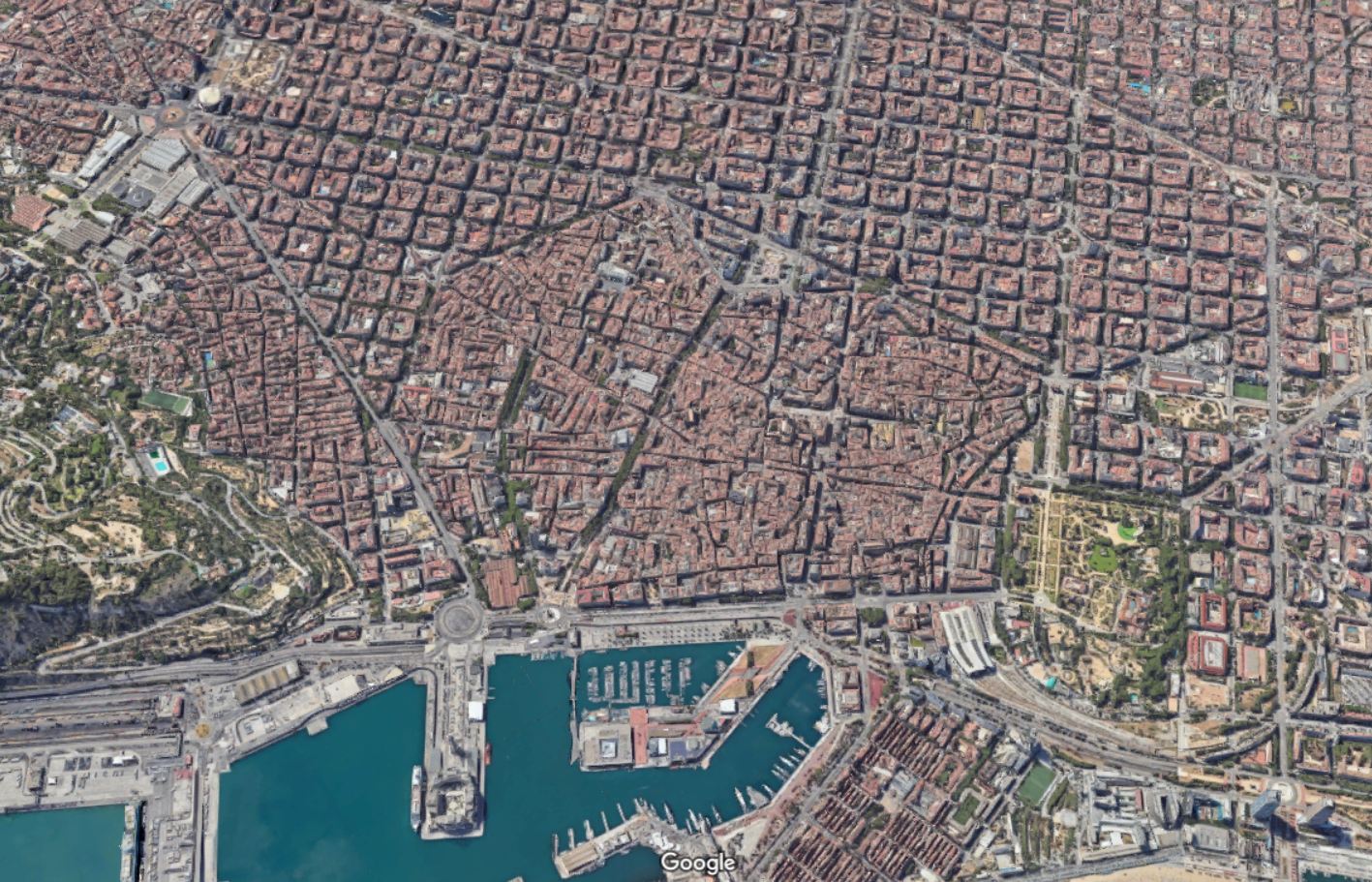
Let’s continue with our theme of city blocks and talk about another city with a noteworthy street grid: Barcelona. Up until the middle of the 19th century, Barcelona was a tiny medieval city hemmed in by 6 km of walls and totalling just over 2 square kilometers. If you look at a map of the city today, it’s pretty easy to see where this was:
This was of course done for military purposes. Barcelona’s medieval walls helped the city resist siege after siege. But the result was also overcrowding, unsanitary conditions, and a generally low life expectancy. So after much debate, it was eventually decided that the walls would need to come down and that the city would need to expand outward.
This then raised the question: how should it be done?
Enter a civil engineer named Ildefons Cerdà. Created in 1860, the Cerdá Plan for Barcelona was a continuous grid of blocks intended to guide the future growth of the city, similar to what the Commissioners’ Plan did for Manhattan. The blocks measured exactly 113.3 by 113.3 meters and each was to have a central open space of at least 800 square meters.
In his original plan, the streets were to be 35 meters wide. But supposedly these were narrowed to no more than 20 to 30 meters due to criticism from the public. Wide streets and more lanes were, I guess, not seen as a benefit in the second half of the 19th century. Either this, or landowners simply wanted bigger buildings.
The Cerdá Plan got approved in 1860 and, today, the city looks like this:
One particularly unique feature of this plan was that the blocks all had/have chamfered corners. This improved visibility at the intersections, as well as created opportunities for public spaces and other uses. For better or for worse, today, you’ll find parking for cars and scooters, bike share stations, ramps leading to underground garages, patios, and more.
The heights of the buildings on each block were also intended to be capped at a consistent height. But even with relatively few tall buildings, the Cerdà Plan led to one of the densest cities in Europe. Today, it is also viewed as a highly livable and desirable city. Hence why the city announced a total ban on short-term rentals. Too popular.
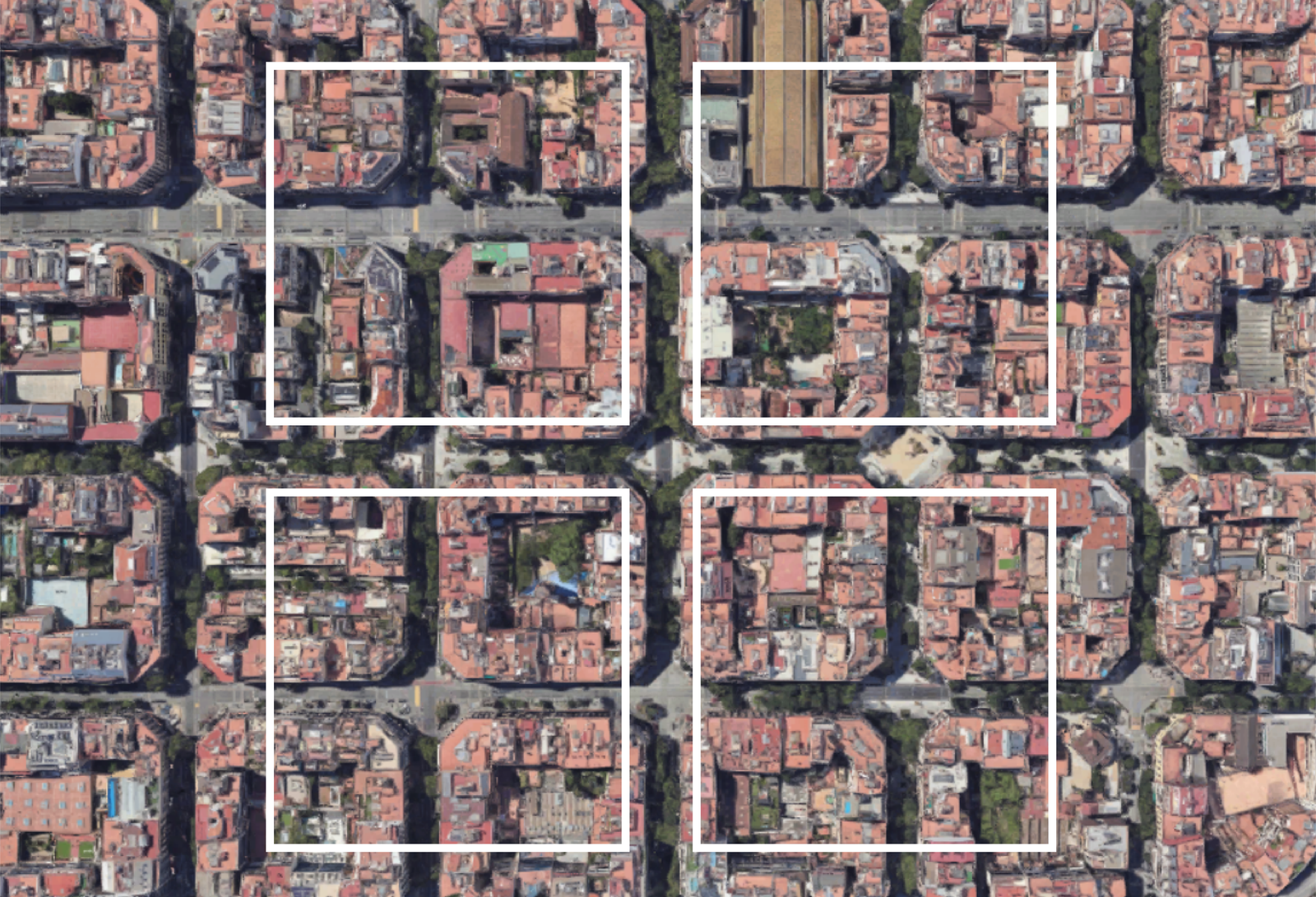
Now for a comparison. Last week we spoke about Salt Lake City’s large city blocks (here and here). And so for fun, here’s what these blocks would look like on top of Barcelona:
The most obvious takeaway is that Salt Lake City has larger city blocks than Barcelona, and that’s one reason why, objectively, Barcelona is more walkable and urban than SLC. But I think you could also view this graphic as a tremendous opportunity.
Barcelona is in the midst of rethinking its urban fabric around something called “superblocks.” The idea here is to cluster blocks together and then concentrate transit and vehicular traffic along its edges, creating a more pedestrian-focused center. For example, in its largest form, a superblock might be a 3 x 3 grid, creating a grouping of 9 city blocks.
But it doesn’t necessarily need to be a 3 x 3 grid. Other permutations are possible and the city plans to eventually introduce over 500 of them.
The first superblock was implemented in 2017 and, not surprisingly, it improved air quality, increased quietness, and led to a significant decrease in car usage (-92%). Interestingly enough, it only led to a moderate increase in car traffic on surrounding streets (+3%). Traffic can be a funny thing.
Creating superblocks out of smaller blocks is naturally easier than the opposite. You have an existing grid to work with. But there’s no reason that the opposite can’t also be done. And I think that’s one way to look at Salt Lake City’s street grid. It already has its superblocks. Now it’s just a question of creating all of its smaller blocks.
Conventional planning wisdom tells us that smaller city blocks are generally preferable to larger city blocks. They make for more interesting walks (which can change our perception of distance) and they improve overall connectivity. This is why you’ll often hear planners advocate for things like “mid-block connections.” It is a way of creating the feeling of smaller blocks.
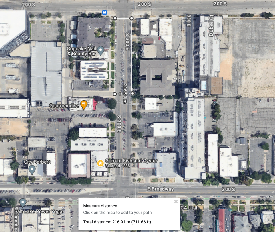
Salt Lake City, as we have talked about, is the opposite of this. Its blocks measure 660 feet x 660 feet (call it 200m x 200m for those of us more accustomed to using the international standard for measuring things). This means that if you were to walk only 2 blocks (inclusive of 2 streets), your walk would be close to 500m, which is a commonly used walking/transit radius.
Things get a bit tricker when you’re not walking in a straight line. For example, if you found yourself wanting to cross a street somewhere in the middle of a block — and you wanted to obey all traffic safety rules and not jaywalk — you would need to walk over 200m just to get to the opposite side. So basically a whole other block.
There are also instances where even this street grid gets interrupted. This past weekend, I spent an evening walking to and from dinner on Main Street. And at one point, I got caught trying to cross the convention center (which occupies 3 blocks). I guess I could have tried to cut through, but I walked around, which added 2 additional blocks (~600m in total).
Thankfully, SLC also has many instances of new mid-block streets/connections, road diets, internal laneways, and enhanced center medians, among many other things. I mean, here are some plans to turn Main Street into a pedestrian promenade. All of these interventions are an effort to soften the city’s underlying block structure, which we know tends to be indelible in cities.
In 1620, an Englishman by the name of Edmund Gunter invented a land surveying device known as Gunter’s chain. As the name suggests, it was an actual chain (see above). Each chain contained 100 links and, when fully extended, it measured 66 feet.
This was a monumental innovation as it greatly simplified land surveying and made it a lot easier to measure out acres — especially if you maybe weren’t great with math. So it is perhaps no surprise that this simple device forever changed our cities.
But first, here’s the only math you need to know:
Number of chains x number of chains / 10 = number of acres
For example:
A lot measuring 66 feet by 66 feet would mean it has an area of 4,356 square feet, or 0.1 acres (1 acre = 43,560 square feet). It would also mean that this lot measures 1 chain by 1 chain, or 1 square chain. Take 1 square chain and divide it by 10, and you arrive at the same 0.1 acres.
Similarly, a lot measuring 660 feet by 660 feet would mean it has an area of 435,600 square feet, or 10 acres. Using Gunter’s chain, this lot is 10 chains by 10 chains, which equals 100 square chains. Divide 100 square chains by 10 and you arrive at the same 10 acres.
Put differently, 1 acre equals 10 square chains in Gunter’s system.
Because of its simplicity and utility, the chain became a statutory unit of measurement in England by the 1670s. And as a result, it spread throughout the British Empire, meaning it started to influence how new cities were being planned and laid out.
Let’s look at the example of Salt Lake City.
We have spoken before about the city’s famously large blocks. They have the dubious distinction of being the largest in the US. But what you may not have noticed is that the typical SLC block measures exactly 660 feet x 660 feet. Its typical streets are also 132 feet wide.
This is because of Gunter’s chain. These are 10-chain x 10-chain blocks and 2-chain streets.
The same is true of other cities. Looking on the other end of the spectrum, Portland’s compact street grid is comprised of blocks that measure 198 feet x 198 feet. These are, in other words, 3-chain blocks. Its typical streets are also 33 feet wide. So half-chain streets.
Units of measurement have a lasting way of influencing how we plan and design things. This is true at small scales and it’s also true of our cities. In tomorrow’s post, we’ll look more closely at Salt Lake City’s street grid and what it does to walkability.
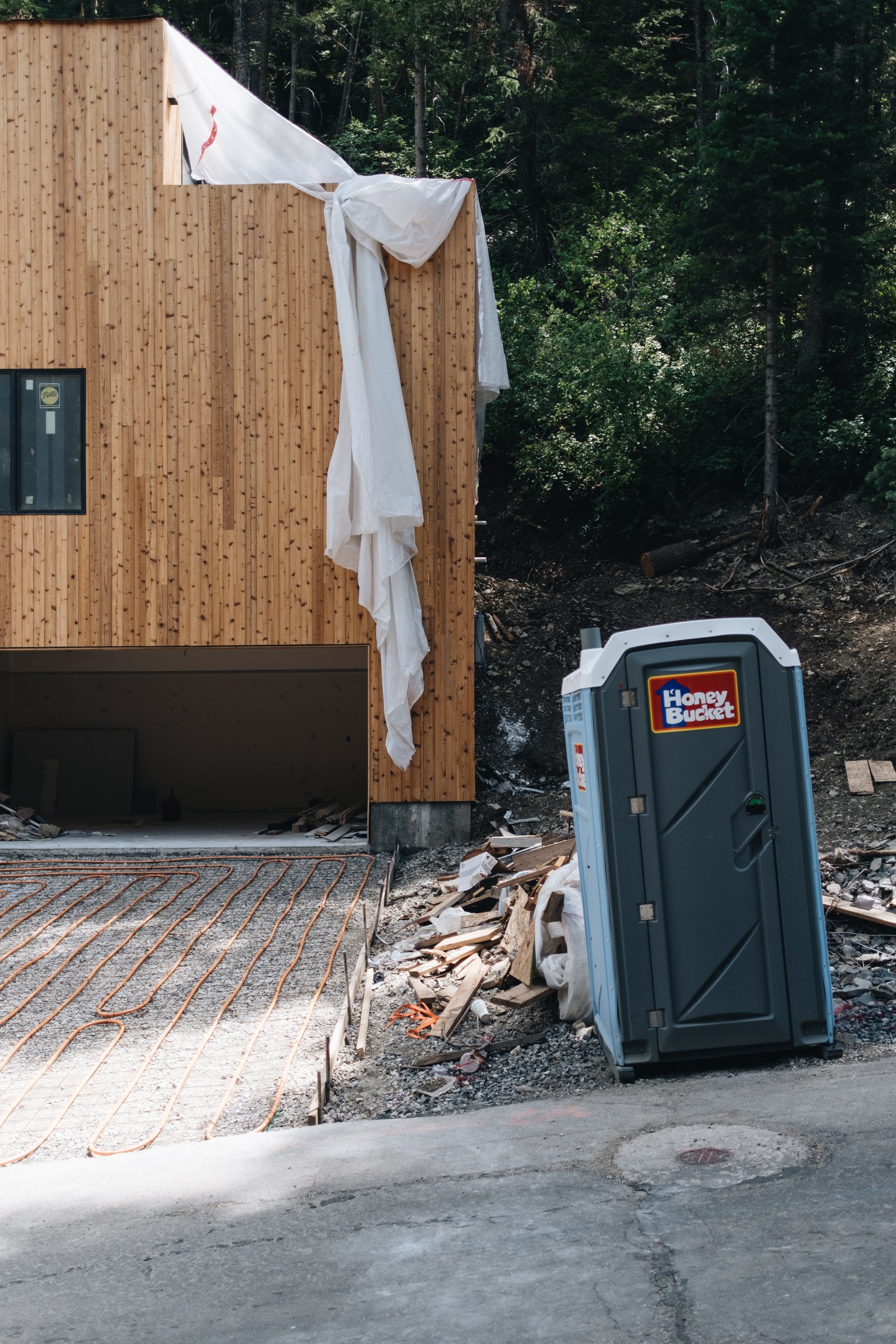
We are into the final push at Parkview Mountain House. The radiant tubes are in for the heated driveway and walkway (essential), and the concrete is scheduled to be poured later this week. The kitchen countertops were installed this morning, and the backsplash was templated, with install scheduled for this Wednesday. The finish carpenter is back this week, and then the painters will be coming next week. The appliances and hot tub are also on standby in their respective warehouses and will be delivered to site as soon as the team is ready. As always, things are frenetic. But we’re pushing to get occupancy this month. I’m also excited to announce that we just hired an excellent management company. We’re in the midst of that onboarding process, and we’re looking forward to starting bookings sometime this fall. If you haven’t yet added yourself to our list, drop your email over here. We’ll be offering a bunch of discounted bookings on a first-come, first-served basis to the people on this list.
In my humble and partially biased opinion, two of the greatest places on earth to snowboard are the French Alps and Utah. I say the French Alps because, after 13 years of annual trips, I have yet to find better food and better après parties. And I say Utah because it’s, like, pretty hard to beat the greatest snow on earth.
France was the preferred choice since June. And Utah was the only choice for 2034. To host the Winter Games, you generally need to have at least two things: money and snow. And right now, fewer places want to spend the former on something that may or may not generate an ROI, and fewer places are getting the latter.
Remember this post looking at the impact of climate change on the Winter Olympics?
Because of these challenges, there is talk of the IOC adopting a permanent rotation of Winter Olympic cities. And Utah has been eagerly positioning itself to be one of the places. Biases aside, this feels like an obvious choice. Salt Lake City has some of the best and most accessible snowboarding in the world (SLC is a great airport) and — most importantly — it still snows there.
Last year, I wrote about how Salt Lake City wants to build a new linear park around its downtown. That post can be found, here.
Fast forward to today, and the city’s Department of Economic Development has just published a new comprehensive 215-page study that supports turning Main Street into a pedestrian promenade.
Specifically, the area running from South Temple to 400 South, and including 100 South from Main to West Temple:
As part of the study, they highlight a number of successful case studies from around the world, including 16th Street Mall in Denver, Bourke Street Mall in Melbourne, and Queens Quay here in Toronto.
In the case of Denver, they cite the one-mile stretch as single-handedly generating over 40% of the city’s total downtown tax revenue! And in the case of Toronto, they refer to Queens Quay as a global destination. (Toronto readers, do you agree?)
Like most city building initiatives, this vision is will take years to realize. But it’s interesting to note that, of the eight design alternatives included in the study, there is already one clear preference within the local community — option B.
Option B is a pedestrian/transit mall, but with multi-use trails. In other words, it is a no-cars-allowed alternative that would still allow bicycles and scooters. Here’s the street section:
If you’d like to download a copy of the full Main Street Pedestrian Promenade Study, click here.
On Monday morning, I flew on Delta from Salt Lake City to Toronto, which in this direction takes just over 3 hours. And it was my first time ever experiencing reasonably reliable wi-fi on a flight. Maybe this is already common for the people who fly in the front of planes, but for me, I’ve never had the wi-fi work so well.
Usually it goes like this: I try and connect, everything is painfully slow, and so I get frustrated and move on. But this time around, I was able to check all of my emails, download fairly large PDFs, mark them up on my iPad, and write yesterday’s blog post. It was pretty great, and it allowed me to land in Toronto with far less anxiety around my work backlog.
But it also got me thinking about what this means for travel and work. If you’re a regular reader of this blog, you’ll know that I greatly prefer working in an office with my team. I think proximity matters.
At the same time, I recognize that technology is empowering new kinds of remote work, that we are all becoming more globally connected, and that, in the future, most of us are likely to travel more, rather than less. This will be for both work and for fun.
While solid in-flight wi-fi may not seem like that big of a deal, in my mind it’s a game changer. People will become more mobile if they can sit on flights and actually be productive (and maybe Apple Vision Pro helps with this). It is another step in what feels like an ongoing untethering of work.
Sometime before the Paris 2024 Olympics this summer, the International Olympic Committee (IOC) is expected to announce who will host the 2030 and 2034 Winter Games. Right now, the two frontrunners are thought to be the French Alps and Salt Lake City/Park City — I think respectively.
Obviously these are two fantastic winter locations. But one of the things that the local committees need to do before they can secure the games is show the IOC that they have enough hotel rooms on hand. More specifically, they need 24,000 rooms reserved for 33 nights. This covers 17 nights during the games, 14 nights before, and 2 nights after.
Most of these rooms, about 10,000 or so, will go to journalists.
I didn’t fully appreciate — or I just didn’t think about it — that this was something that needed to be done 6-10 years out. Because right now there is a human running around try to lock up these rooms in advance of the decision this summer.
According to the Salt Lake Tribune, they’re already at 85% of the requisite 24,000 rooms. Though some of these rooms have yet to be built and some of them reach into neighboring Wyoming, which apparently isn’t an atypical distance when it comes to meeting this accommodation requirement.
For obvious reasons, I’m rooting for Utah here. I really want them to get the Winter Games.