Daily insights for city builders, delivered every morning at 6 AM ET. I’m Brandon Donnelly — a Toronto-based real estate developer and founder of Globizen. I’ve been writing here since 2013.

Tag: walkability

  • Mapping 15-minute cities

    This is an interesting map to play around with. It allows you to see how many 15-minute neighborhoods and cities there are around the world. And it works by calculating the average time it takes to walk or bike to the closest 20 points of interest in 10,000 cities. These points include all of the usual suspects like places of work, schools, healthcare institutions, grocery stores, and so on. A blue cell indicates an average walk time < 15 minutes, and a red cell indicates an average walk time > 15 minutes. The darker the color, the shorter or longer the average time in minutes.

    By this measure, it’s hard to beat many/most European cities. Here are Paris and Barcelona:

    The city propers are completely blue, and you have to go pretty far out (or up into mountains) to find areas that don’t have 15-minute conveniences.

    Toronto has a strong core and isn’t terrible overall, but expectedly, we aren’t as uniform and as deep blue as Paris and Barcelona:

    Where things get really interesting, though, is when you look at cities like Dallas and Houston:

    It’s clear where these cities stand on walkability.

  • Big blocks and walkability

    Conventional planning wisdom tells us that smaller city blocks are generally preferable to larger city blocks. They make for more interesting walks (which can change our perception of distance) and they improve overall connectivity. This is why you’ll often hear planners advocate for things like “mid-block connections.” It is a way of creating the feeling of smaller blocks.

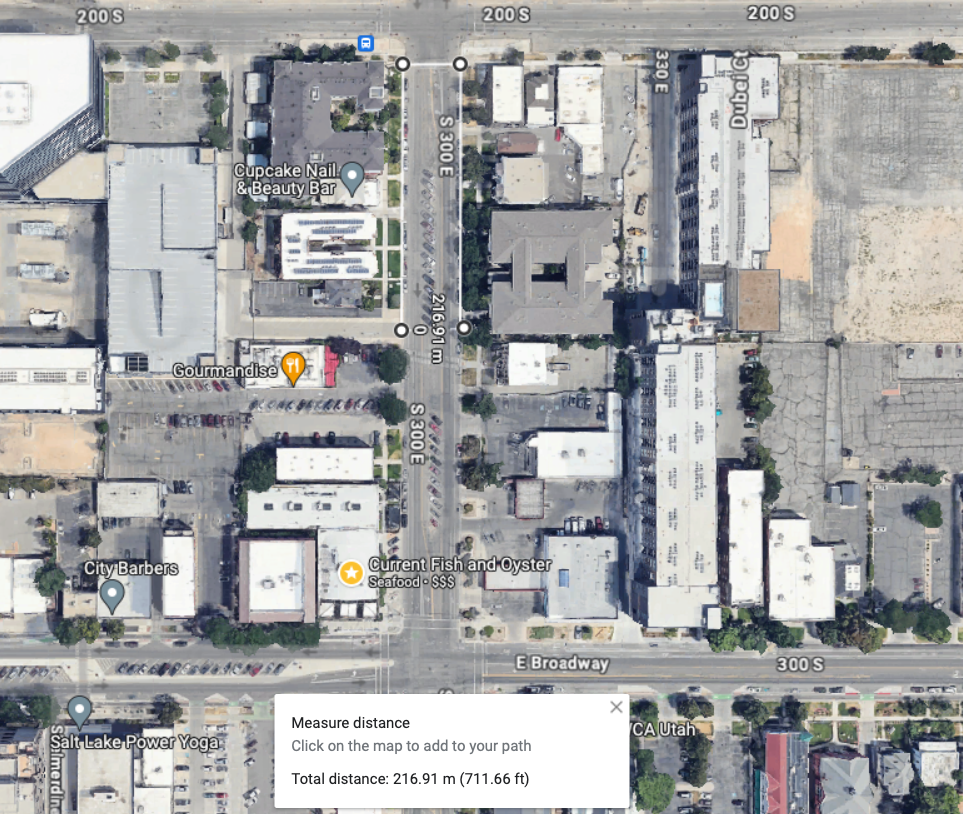
    Salt Lake City, as we have talked about, is the opposite of this. Its blocks measure 660 feet x 660 feet (call it 200m x 200m for those of us more accustomed to using the international standard for measuring things). This means that if you were to walk only 2 blocks (inclusive of 2 streets), your walk would be close to 500m, which is a commonly used walking/transit radius.

    Things get a bit tricker when you’re not walking in a straight line. For example, if you found yourself wanting to cross a street somewhere in the middle of a block — and you wanted to obey all traffic safety rules and not jaywalk — you would need to walk over 200m just to get to the opposite side. So basically a whole other block.

    There are also instances where even this street grid gets interrupted. This past weekend, I spent an evening walking to and from dinner on Main Street. And at one point, I got caught trying to cross the convention center (which occupies 3 blocks). I guess I could have tried to cut through, but I walked around, which added 2 additional blocks (~600m in total).

    Thankfully, SLC also has many instances of new mid-block streets/connections, road diets, internal laneways, and enhanced center medians, among many other things. I mean, here are some plans to turn Main Street into a pedestrian promenade. All of these interventions are an effort to soften the city’s underlying block structure, which we know tends to be indelible in cities.

  • We’re far from full

    I tweeted this out yesterday:

    What I was getting at is that there’s lots of available room within our existing boundaries for infill housing. We are nowhere near full, despite what some people will tell you. In fact, most areas are not dense enough to properly support modes of transport that aren’t the car.

    Of course, there are a number of ways that one could be offended by a statement like this.

    One, you could argue that more density would make the city unlivable. Two, you could get into the chicken-and-egg game of whether a more expansive transit system is needed before allowing more density. Three, you could say that we already have enough zoned and unbuilt housing supply — so why do we need more? And I’m sure that there are many others that I’m not mentioning here.

    Density can be a counterintuitive feature for cities. It can actually make a place more livable by encouraging more amenities adjacent to where people live and work, and it can also reduce traffic congestion by empowering alternative forms of mobility. If the only reasonable way to get around is by car, then of course most people will drive.

    We also need to avoid the chicken-and-egg mental trap when it comes to mobility infrastructure. Land use and transportation always work hand in hand and need to be thought of and executed on simultaneously.

    Finally, the objection of already having lots of sites zoned for new housing is an enticing one. But zoned and delivered are two vastly different things. And the unfortunate reality is that there are a lot of zoned sites that won’t be able to develop in the short and medium terms because the market isn’t there. But that doesn’t mean that other housing typologies couldn’t be built.

    At the same time, we need move away from “cruise ships of urbanity.” Broadly speaking, Paris — to cite just one of many examples– is at least and on average about 4x denser than Toronto. And somehow, people still like living and visiting there.

  • A national walk to work day alternative

    I just learned that the US has a “National Walk to Work Day.” And it happens to be today, Friday, April 7, 2023. It was started in 2004 by the federal government and the American Podiatric Medical Association — because, you know, walking is good for your feet — and the idea is that since so few Americans actually walk to work, we should encourage them to do it at least one day of the year. Back in 2019, the figure was that less than 3% of Americans do it on average.

    While I’m sure that there are some good intentions here, I’m guessing that the impact of this national day is probably somewhere between zero and “I guess I’ll park in a farther spot at the office park today.” The reality is that a day like this exists because we have spent the last 75 years, or even longer, making it exceedingly difficult to navigate our cities without a car. So it is equal to, “let me speak out of the other side of my mouth for a day.”

    But we also know that a real and meaningful solution is pretty simple to achieve (though clearly not easy). Build smaller streets and build more densely, especially next to transit. (Would you add anything to this?) So I think it’s time for a new kind of national day. Maybe it’s a day where every dense development proposal next to transit just gets automatically approved. It would be a national day for “this took too long, so here you go.”

    I don’t know, this probably needs some work. I’m open to other ideas here.

  • No sidewalks — feature or bug?

    I tweeted the above photo on Saturday morning with the following text: “No sidewalks. Towers in the distance. Welcome to the inner suburbs of Toronto.” What I, of course, wanted to highlight is the contrast between the rural-like street with no sidewalks in the foreground, and the high-density towers built on top of Kipling subway station in the background. It is a perfect example of the kind of Toronto we are building, by design, all across the city. And it also exemplifies one of our great philosophical divides.

    If you look at the responses on Twitter, you’ll see that there are a few opinions. Generally speaking, though, there are probably two main ways to think about this scene. One way is to look at the transit-oriented housing and think of it as urban progress. We are adding new housing and we are doing it in a way that hopefully results in more walkable communities. With this in mind, you might now see the three humans on the street (one of which is in a stroller) and think it’s a shame that they have been forced to walk on the road.

    The other main way to look at this is that not having sidewalks is actually a feature and not a bug (indeed, a lack of sidewalks can be a pretty good indicator for rich people/wealthy households). From this lens, not having sidewalks means uninterrupted driveways (more parking), less through foot traffic, and a more quaint small-town feel. Also with this lens might be a view that the rural-like street was there first, before the transit-oriented towers. And it was doing just fine before people like me drove through their neighborhood and pointed out the lack of sidewalks.

    How do you see this scene?

  • Walkable areas are a scarce commodity in cities

    According to this recent report by Smart Growth America, which looked at “walkable urbanism” in the largest 35 metro areas in the US, only about 1.2% of land is, on average, built out in this way. Everything else needs to be driven.

    But here’s the thing. Humans seem to really enjoy walkable urbanism, and will usually pay more for it:

    City dwellers will pay to live in a walkable location. Real estate in these areas averages a 34% price premium per square foot in for-sale housing and 41% for multifamily rental apartments.

    It also, by definition, punches above its weight:

    Walkable neighborhoods in just those 35 metro areas account for 19.1% of the total US real GDP and 6.8% of the total US population, by the researchers’ calculations.

    That’s how density works. You get to do more, with less.

    At the same time, not every place should be Midtown Manhattan (which the report labels as the highest walkable urban place with a floor area ratio of 40). There are a wide range of densities that will work, including modest ones (FARs between 1-3).

    Here in Toronto, many of our single-family home neighborhoods have densities that are zoned for a maximum FAR of 0.6, which is quite restrictive if you’re hoping to build something like a multi-unit building.

    This is, of course, the point. But imagine what all could be done here with even an incremental change.

  • Where the rich don’t drive — is density the new luxury?

    This data is from 2019, but I imagine that things would look pretty similar today and that it might even be a little more pronounced. The dataset from the above article looked at how many people have cars in a given area (a darker dot = fewer cars) and then plotted this against population density and income per capita.

    Here’s what that looks like for the regions of New York, Boston, Los Angeles, and Houston (data from 2013 to 2017):

    What is fascinating about these charts is that they show two different correlations. In dense and transit-rich cities such as New York and Boston, car usage is most closely linked with population density and not with income. The dark dots form a horizontal line near the top.

    However, in the case of Los Angeles and Houston, car usage is instead most closely linked with income and not with population density. The dark dots form a vertical line near the left — the lowest income per capita.

    So what does this tell us?

    It tells us that if you design a city to broadly require a car, then you are likely to sort people based on those that can afford a lot of car and those that cannot. On the other hand, if you design a city around transit, then you are likely to instead create a place where both the rich and poor get around in similar ways.

    There is also evidence that the latter is being increasingly viewed as more desirable. 2017 was the first year in the US where high-income young people (ages 26 to 33) drove less than low-income young people. Presumably these high-income people had choices, and so I tend to view this as a preference.

    As a whole, this is surely a good thing for our cities. But now I think we need to be careful not to allow density and walkability to become the new luxury that only the rich can afford.

  • Houses with large yards and where you have to drive to places

    The National Association of Realtors in the US has a “Community and Transportation Preference Survey” that it conducts usually every two years. Last year (2020), wasn’t supposed to be a survey year, but given the pandemic, they decided to run it in June and see if people’s preferences had changed at all during that time.

    Last June feels like eons ago to me and I bet that if you asked people how they were feeling today it may be slightly different. Nonetheless, the survey asked 2,000 adults from the fifty-largest metro areas a bunch of questions about where and how they live and where and how they might want to live in the future.

    The topline results can be found over here. But for a bit of context, 58% of respondents were people who lived in a single-family detached house; 26% of respondents were people who lived in a building with two or more apartments and condos; and the rest of the respondents were split across townhouses, rowhouses, mobile homes, trailers, and other. (I’m kind of curious about the 2% who answered with other.)

    One of the questions that I thought might be interesting to this audience is this one here about housing preferences going forward:

    The question asks the respondents to imagine that they are moving into another home. It then asks about priorities and, more specifically, about their preferred trade-off between amenities and walkability versus a large detached house with a big yard.

    Overall the split in preferences has remained close to 50/50 over the last three surveys. But there appears to be a small uptick toward large homes and less amenities. I wouldn’t be surprised if the pandemic contributed to this thinking last summer. But who knows if this will persist. At the same time, actions speak louder than words.

    My response to the above question would be less space, greater walkability, and more amenities. I have no desire to live in a low-rise grade-related house, especially one that is disconnected from the city. I like urbanity. What about you?

  • Location over space

    This recent article about the kind of homes that “wealthy millennials” are buying is a useful reminder of just how expensive homes are in San Francisco. But it’s also interesting in that it speaks to the types of homes that people with options are deciding to buy. In other words: If you had all the money in the world, what would be your ideal home? (According to the article, there are about 618,000 people in the US between the ages of 24 and 38 who have a net worth of at least $1 million.)

    Traditionally, “luxury” has meant lots of square footage and a big lot. But as we know, that view is changing for some/many people. We are placing a greater emphasis on being closer to the city and on living in more walkable communities. The article provides a number of examples where historically desirable areas have lost ground to areas that are now popular with the under 40 set. And in some cases, there has been a complete reversal; areas have gone from being more expensive to now less expensive (on a per square foot basis).

    It would seem that being able to work from anywhere hasn’t made us forget the city.

  • Morning bagel run

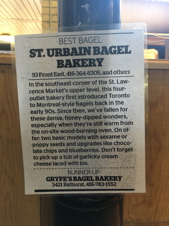
    image

    This morning I woke up and decided that I could go for a bagel with lox and cream cheese. I figured, it’s the weekend, I’m going to treat myself. So I walked across the street to St. Urbain Bagel Bakery (see above photo).

    My Montreal friends reading this are probably thinking that this is no substitute for a Fairmount or St-Viateur bagel. But I enjoy St. Urbain. They are my go-to place for breakfast in the market.

    What I really value, though, is the ability to walk across the street and grab a bagel for breakfast. It’s a pretty simple action. Nothing complicated about it. 

    But in our world of constant traffic jams, cars that should soon drive themselves, and near-instantaneous online delivery, it can be easy to forget that there’s still something really nice about just walking down the street in the morning and saying hello to a human.

    I feel lucky that my neighborhood allows me do this. Not all do.