Daily insights for city builders, delivered every morning at 6 AM ET. I’m Brandon Donnelly — a Toronto-based real estate developer and founder of Globizen. I’ve been writing here since 2013.

Tag: walkability

  • Journeys by walking

    Arup, the global consulting firm, has an interesting publication out called Cities Alive: Towards a walking world. The report highlights 50 benefits of walking and then 40 actions that city leaders can take today to transform their cities. The entire study was informed by examining 80 international case studies.

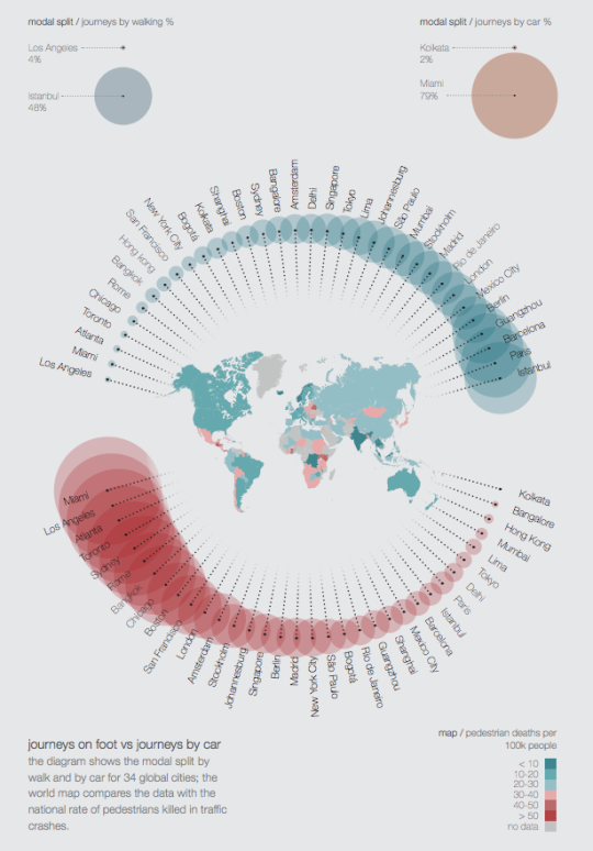
    As I was going through the report, the following diagram caught my attention. It compares journeys on foot vs. journeys by car for a collection of global cities.

    The turquoise circles represent % of journeys by walking. On the left is Los Angeles at 4%. And on the right is Istanbul at 48%.

    The red circles represent % of journeys by car. On the left is Miami at 79% (with Los Angeles right beside it). And on the right is Kolkata at 2%.

    The map in the middle of the circles represents pedestrians killed in traffic crashes per 100,000 people.

    I’m not sure where the data was drawn from, but it’s not all that surprising to see a few North American cities clustered towards the left (less walking; more driving). Still, I wonder how “journey” is defined.

    To view the full report, click here. Arup also produces a lot of other great content that you can download for free, here.

  • Big box stores are the new noxious-use

    As a follow-up to yesterday’s post on New Urbanism, I thought I would post an interesting video discussion between Andrés Duany and Ben Stevens. 

    Duany is the father of New Urbanism and Stevens runs a great blog called The Skyline Forum where he interviews notable city builders, developers, architects, planners, and so on. If you can’t see the video below, click here.

    [youtube https://www.youtube.com/watch?v=QfZZ61C4YOY?rel=0&w=560&h=315]

    Once again it’s a great reminder that so much of what we do and build in our cities is dictated by parking requirements. One of the ways Duany differentiates New Urbanism from “old urbanism” is that the new explicitly provides for the car. 

    Regrettably, I think we do that almost everywhere nowadays. But I take his point that New Urbanism happens almost as an intervention in areas where there are few or no other mobility options besides the car.

    I also thought it was interesting that Duany refers to big box stores as the new noxious-use in cities, rather than industry. He describes the parking, not the stores themselves, as creating a “flume of unwalkability.”

    It always seems to come down to parking.

  • Fabricating a new urbanism

    image

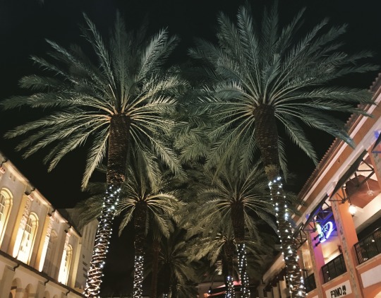
    Last night I was in CityPlace, West Palm Beach. Completed in 2000, CityPlace is a quintessential example of New Urbanism. (For those of you from Toronto, this is a different kind of a CityPlace.)

    In case you’re unfamiliar with this movement, here’s a snippet from The Charter of New Urbanism (via Wikipedia):

    “We advocate the restructuring of public policy and development practices to support the following principles: neighborhoods should be diverse in use and population; communities should be designed for the pedestrian and transit as well as the car; cities and towns should be shaped by physically defined and universally accessible public spaces and community institutions; urban places should be framed by architecture and landscape design that celebrate local history, climate, ecology, and building practice.”

    At a high level, New Urbanism makes a lot of sense. American cities were sprawling uncontrollably and so advocates had decided that something had to change. The Congress for New Urbanism was founded in 1993.

    But the New Urbanism movement has had its share of critics. Here’s how Witold Rybczynski – professor at the University of Pennsylvania – talked about it on his blog:

    “What are the important ideas that have affected American cities in the last 20 years? The development of waterfronts. The renaissance in constructing urban parks. The move of genXers and retirees into downtowns. High-rise urban living and Vancouverism. The popularity of urban bicycling and bike-rental programs. Ditto for Zipcars. Urban farmers markets and community gardens. Urban charter schools. The dramatic expansion in attendance of urban cultural institutions, especially art museums. Urban tourism. Downtown trophy buildings. The emergence of influential big-city mayors. Have any of these been the result of the new urbanism movement?”

    Frankly, I have never been a big follower of New Urbanism. It has always felt artificial to me. But I recognize the immense challenge in transforming car-oriented cities and communities into walkable ones. It’s one of the greatest challenges in city building. You’re asking people to change their habits.

    If any of you are experts on New Urbanism (because I am certainly not), I would love to hear from you in the comment section below.

  • The future of housing in Toronto

    On Monday evening I gave a 45 minute talk at the Rotman School to a delegation of about 70 people from Portland. The talk was about Toronto housing, but more specifically about the history and possible future of high-rise housing in this city. 

    Thanks to everyone who commented on my lead-up post over the weekend. It was really helpful to hear what other people in this city (as well as people not from this city) are thinking. Many of the comments also echoed my own beliefs.

    The narrative I told in my presentation was about two significant, yet very different, periods of time when Toronto built more high-rise than low-rise housing. The first was our post-war suburban slab tower boom. And the second, which we are currently living through, is really the outcome of the Places to Grow Act (2005).

    But as I mentioned over the weekend, the really interesting question is: what’s next?

    In my view, what we are seeing today is fundamentally different than what we saw in the post-war years. Despite the fact that we were building towers then and we are also building towers now (albeit much taller ones), the ideology behind them has changed. It has gone from suburban to urban.

    Toronto’s post-war towers were built upon a particular dream. The dream of getting in your car, escaping the decay of the city, whisking up the Don Valley Parkway (nobody whisks on the DVP), and being rejuvenated by all the light, air, and green space afforded to you in your Ville Radieuse.

    But it turns out that people of means didn’t want that back then. They wanted a suburban house. That was the dream.

    Today, however, cities are back in vogue

    Companies are moving into city centers to compete for the best talent. Retailers are moving downtown to capture disposable income. And the most pressing problems are no longer about decay and urban blight, they are about housing affordability, gentrification, and too many rich people pushing out the poor.

    The narrative has changed.

    So in the context of Toronto, I feel as if we are at an inflection point when it comes to housing. The multi-family dream may not have stuck decades ago, but I believe it will stick for many, though not all, today. And this will happen for a variety of reasons ranging from sheer preference to sheer necessity. The alternative is no longer an affordable bungalow on a 50′ x 150′ lot that happens to be 10 minutes from the subway.

    But as a result of this shift, I also think a number of other things will happen. 

    Eventually, Toronto will look to loosen some of the land use restrictions on its single family neighborhoods. This could mean “gentle” low-rise intensification (new planning buzzword, take note), as well as the acceptance of laneway or accessory dwelling housing. This won’t be popular, as one person said in the comments over the weekend, but eventually the pressures will become too great.

    At the same time, I think we’ll be brought full circle with respect to our suburban towers. The suburban ideals in place at the time means that many of these tower communities have relatively low densities. That represents a tremendous opportunity for this city and it’s only a matter of time before we truly figure out how to unlock them.

    But for all the change and disruption that’s happening in Toronto, I think it’s also worth saying that those of us who live here should consider ourselves a lucky bunch.

    One of the things I actually asked the delegation from Portland was, what struck you the most when you arrived in Toronto? The response I got was: its vibrancy. 

    Everywhere you walk downtown, they said, people are on the streets – walking, cycling, and hanging out. In fact, some said it’s almost hard to remember which street is which because every street seems to be so full of activity. Most North American cities do not have this kind of sustained vibrancy in the core, I was told. And so that makes us a pretty special place. We must be doing something right.

    It’s easy to take those sorts of things for granted when you live somewhere. So today I’m trying to do the exact opposite of that. I’m trying to stop and appreciate the place I call home.


  • From suburban houses to downtown condos

    Last Friday the Financial Post published an interesting article talking about Mattamy Homes and the new office that its founder, Peter Gilgan, is in the process of opening up downtown in the Toronto-Dominion Centre (which just so happens to be my favorite office complex in the city).

    At 64 years old, Peter recognizes that his company has changed and the world has changed. He he himself recently moved downtown and now he’s bringing his company with him.

    “Our Oakville office [a western suburb of Toronto] is a reflection of what our business was 25 years ago,” he says. “We were a local, west-end Toronto builder. Now we’re the largest home builder in Canada and we’re the largest private home builder in all of North America.”

    Come September he will move his finance, legal, IT, human resources and strategic marketing team —  about 100 of Mattamy’s 1,100 staff — into the new downtown digs. He wants to attract “the absolute best talent.”

    “The young people seem to really want to work down here. So that’s one reason. The other thing is to make sure the business has the capital to move forward and expand. Well, where’s the capital? It ain’t in Oakville.”

    This of course isn’t a new thing for suburban homebuilders. Many in Toronto have made the switch – or at least expanded – from suburban houses to downtown/urban condos. And I’m assuming that’s what is going to happen here.

    Still, it’s fascinating to see this trend continue. Young people really do want to live and work “down here.”

  • Where the jobs are being created in cities

    According to a new report released by City Observatory, US cities have officially reversed a 50-year trend towards decentralization.

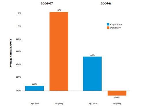
    We know that urban living has been seeing a renaissance over the last decade or so, but as recently as 2002 – 2007 (pre-Great Recession), the suburbs and peripheral areas were still seeing significantly higher job growth: 1.2% per year in the periphery versus 0.1% in the city center. The “city center” is defined as a 3 mile radius around the center of the city in this study.

    However since 2007 things have flipped:

    image

    Chart Source: City Observatory

    Why is this happening? Here’s a snippet from City Observatory:

    The strength of city centers appears to be driven by a combination of the growing attractiveness of urban living, and the relatively stronger performance of urban-centered industries (business and professional services, software) relative to decentralized industries (construction, manufacturing) in this economic cycle. While it remains to be seen whether these same patterns continue to hold as the recovery progresses, (the latest LEHD data on city center job growth are for calendar year 2011), there are structural forces that suggest the trend of center-led growth will continue.

    In some ways, it just makes intuitive sense. People started returning to cities and so the jobs followed (although there were also structural changes to the economy). 

    The big question, however, is whether this trend will continue? My bet is on yes. What do you think?

  • What’s your complete neighborhood?

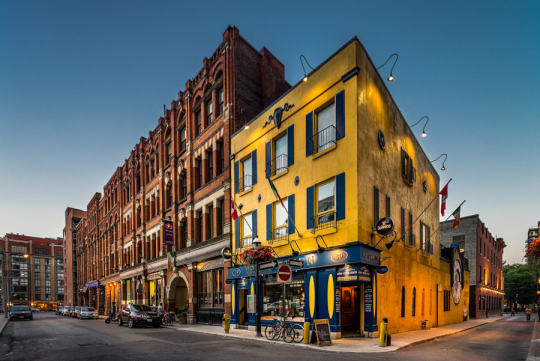
    Photograph Toronto - St Lawrence Market by Chris Dufresne on 500px

    Toronto – St Lawrence Market by Chris Dufresne on 500px

    This past Saturday night I was out with a few friends in my neighborhood (St. Lawrence Market area). And I was delighted to see how busy it was. Virtually every bar or club we walked by had a line down the street.

    Being the city geek that I am, I started thinking about two things: (1) how often I get localized to my neighborhood (I have data to back this up) and (2) what makes a “complete neighborhood”, such that you’re even able to be localized?

    In some ways the idea of a “complete neighborhood” is universal. Everybody needs a grocery store and access to food, for example. But in other ways, a “complete neighborhood” is very much a personal thing – you want goods and services that are important to you.

    So today I thought I would do a quick breakdown of the goods, services, and amenities that I really value in my neighborhood and that I think make it more or less “complete.” This list is a combination of universal and personal choices in no particular order. At the end, I summarize some of the things I wish I had.

    What I have:

    • A 5-10 minute walk to subway and streetcar
    • A 24/7 grocery store
    • A world famous food market (St. Lawrence Market)
    • Staple coffee shops (Starbucks and Balzacs)
    • Lots of restaurant and food choices (including decent Mexican, one of my favorite foods, and Pho, for when I feel a cold coming on)
    • 2 drugstores (Shopper’s Drug Mart and a new Rexall)
    • A great gym that’s less than a 10 minute walk away
    • An outdoor/athletic store that also fixes bikes
    • Cool local bar (AAA) where I can watch the Raptors (because I don’t own a TV)
    • After work bar with a good Happy Hour (Pravda)
    • Patios for the summer (all along the Esplanade)
    • All the major banks
    • Nearby recreational amenities (bike trails, waterfront, etc.)
    • Local employment base (Wattpad, BNOTIONS, etc.)
    • Great architecture (from Daniel Libeskind to the classics)
    • High walkability

    What I wish I had:

    • Less chains and a few more independent businesses
    • A hip indie coffee shop where the (male) staff have waxed moustaches
    • A good takeout sushi place
    • A pool that I could walk to (I ride my bike to Regent Park)
    • A liquor store with longer hours (but alas this is Ontario)

    Those are my working lists. What would create a complete neighborhood for you? And how does your current neighborhood hold up?

  • How I moved over the last 3 weeks

    At the beginning of this year I wrote a post about a mobile tracking app called Moves that I had heard about through my friend Sachin Monga. He had just published a beautiful set maps showing where he physically spent his time in both Toronto and San Francisco.

    His post spurred me to download the app and at the end of my post I promised to share my own set of maps once I had collected enough data points. It’s only been about 3 weeks, but already my maps are starting to fill out, so I thought I would do a release.

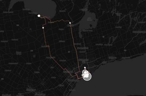
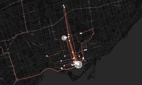
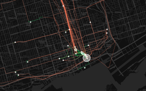
    The orange lines represent transport of some sort (car, subway, streetcar, and so on) and the green lines represent walking. I don’t cycle very often in the winter (I know, I’m a fair-weather cyclist), so you won’t see any of those lines just yet. However if I posted a map from the summer, I know it would look completely different.

    Here’s a first one showing a regional scale:

    image

    Here’s a second one showing the city of Toronto:

    image

    And here’s a third one showing mostly downtown:

    image

    What’s interesting about these maps is how much you can tell about me and the way I move around the city.

    For one, there’s a good chance I ski or snowboard given that I’m driving up to Collingwood, Ontario in the winter. You can also see how heavily dependent I am on the Yonge subway line, which is the thickest orange line in the middle of downtown. It’s also interesting to see how localized I am within my neighborhood (St. Lawrence Market). I walk to get groceries. I walk to the gym. I walk to coffee. And the list goes on.

    This is fairly typical for people living in urban neighborhoods, but it would be interesting to see where it applies in the city and where it begins to fall apart. I would also imagine that there’s a correlation to the area’s Walk Score, although this (Moves) might actually be a better measure since it’s usage data.

    Either way, imagine what cities could do if they had this sort of data for every resident. They would be able to see precise resident flows and then determine exactly where transit and infrastructure investments should be made instead of politicking to determine where they should be made.

    That time is coming.

  • Show Yonge some love

    image

    Since last summer the Downtown Yonge Business Improvement Area in Toronto has been running a really creative community engagement program at yongelove.ca.

    The site includes a short history of Toronto’s most famous street, an Instagram contest (use #YongeLove to participate), and a survey where both locals and visitors can provide their feedback on what they think the future of Yonge Street should be.

    The reason this is being done is because, in 2016, Yonge Street from Davenport Road all the way south to the lake will be ripped up for infrastructure upgrades. And so it was rightly determined that now is the right time to rethink the future of Yonge. Let’s do this once.

    I’ve already talked about the Yonge-Redux proposal here on Architect This City and that seems to be where everyone’s head is at in terms of what they would like to see. I also think it’s the right thing to do for Yonge Street. If you’ve ever been on Lincoln Road in Miami or La Rambla in Barcelona, you’ll know how magical a great street can be.

    So I’d encourage you to complete the Yonge Love Survey and advocate for something awesome. It ends next month, after which time all the feedback will be forwarded to the city.

    I’d also love to hear what you think and how you responded in the comment section below. My response was more or less geared towards supporting the Yonge-Redux proposal.

  • Who are you planning for?

    I just came across the following chart via City Clock:

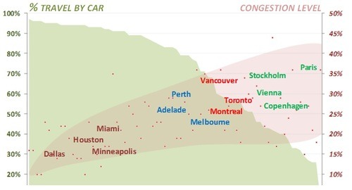
    It came from a study that looked at 74 cities in terms of two measures: the percentage of people that travel by car and the traffic congestion levels within those cities.

    The way to read the chart is to first look at the red dots. Each dot represents one of the cities studied. The position of the red dot corresponds to that city’s congestion levels. So for example, if we were to take Toronto, the congestion level is 27%.

    If you then take that same dot and draw a vertical line to the top of the green shaded area, you get the percentage of people who travel by car. In the case of Toronto, it is 56%.

    What’s interesting about this chart is that as congestion levels rise, it forces people out of their cars. In other words, the cities with the highest congestion levels also have the lowest auto share percentages.

    But the other way I interpret this chart is that the decision is almost binary: you’re either planning for cars or you’re planning for people. Based on this data, it’s hard to have both.