Daily insights for city builders, delivered every morning at 6 AM ET. I’m Brandon Donnelly — a Toronto-based real estate developer and founder of Globizen. I’ve been writing here since 2013.

Tag: transit

  • Mass transit with on-demand service

    Here’s what we know:

    In the mid-20th century, the US made a pivotal choice that shaped its cities, economy and lifestyle. It chose highways and cars over public transit. At the time, this seemed like the future: the freedom of the open road, the allure of suburban living, and the booming post-second world war economy all converged to push America towards a car-centric culture.

    The Federal-Aid Highway Act of 1956 cemented this vision, unleashing a highway system that encouraged suburban sprawl, fuelled the automotive industry and sidelined public transit. Rail systems were seen as relics of a slow, industrial-era technology ill-suited to America’s postwar aspirations. The car was king. 

    But this congested system is breaking. In 1950 about 30 per cent of the world’s population lived in cities. By 2030 this is expected to reach 60 per cent. Infrastructure cannot keep up with this growth. An increase in cars further reduces street capacity.

    What we don’t have a clear consensus on, though, is the path forward. Is it more highways? More public transit? More bike lanes? Or will autonomous vehicles finally arrive and bail us out? The answer will depend on who you ask.

    In this recent opinion piece, venture capitalist Vinod Khosla makes the case for something else: personal rapid transit systems (or PRT). Conveniently, he also happens to be an investor in one — a company called Glydways.

    The promise is an on-demand mass transit system that offers the convenience of a personal car, but with the capacities and price points of public transit. And it is based on small autonomous vehicles riding in their own dedicated lanes.

    Each lane only needs to be 1.5 meters wide, which is less than the 2.3 meters that the Dutch see as the ideal width of a one-way bike lane. And with this, the company claims that it can reach capacities of up to 10,800 people per hour.

    To further put this into perspective, the standard width of a two-way parking drive aisle here in Toronto is 6 meters. So this would mean that each drive aisle could, in theory, have 4 lanes dedicated to these “Glydcars.” That’s how narrow they are.

    Here’s a video of them in operation:

    This, of course, isn’t an entirely new idea. You might remember that Masdar City in Abu Dhabi claims to have opened the world’s first PRT system in 2010 — a 1.4 km line with only two stations. That said, Glydways has already been awarded three projects in the US. So for fun, I think I’ll keep an eye on them.

  • The longest cable car line in the world is in Mexico City

    Mexico City is all kinds of big. It is the largest metropolitan area in North America, the largest Spanish-speaking city, and broadly one of the largest megacities in the world. Because of this, it can be, you know, hard to move around.

    I remember visiting the city for the first time when I was in elementary school, and it standing out to me that everyone had one day of the week when they were simply not allowed to drive their car. It was/is a form of load balancing. Imagine that. (I don’t know if this is still the case, or if it’s even more stringent today.)

    I also remember visiting the city later on, when I was in grad school, and it standing out to me that their metro had women-only cars. This was and continues to be an attempt to try and minimize the amount of sexual harassment that takes place on transit. Again, it can be hard to move around Mexico City.

    The city’s latest solution is one that has found success in other Latin American cities, such as Medellin, and that is: cable cars. Relative to subway or light rail, they’re inexpensive. They’re also good at navigating steep terrain, and their stations can be inserted into dense urban areas. This includes working-class neighborhoods who might otherwise have very limited mobility options.

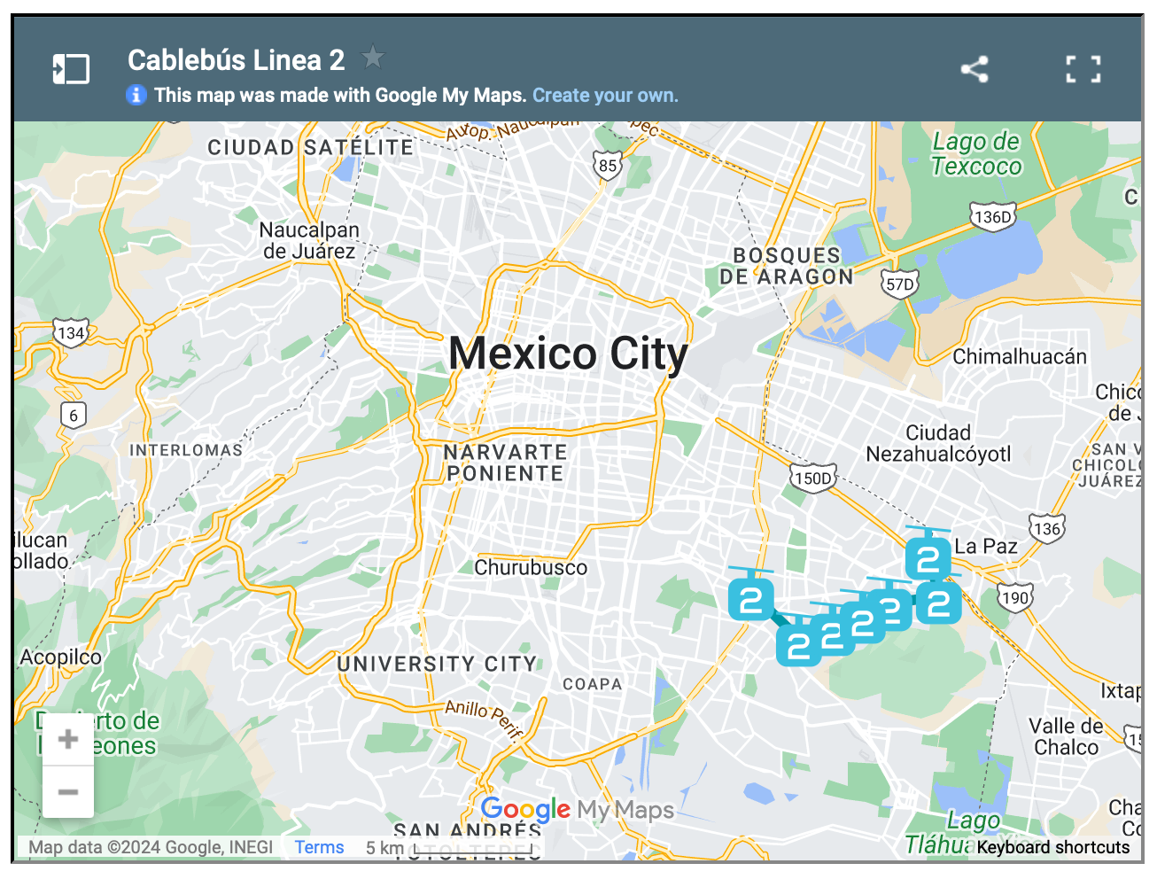
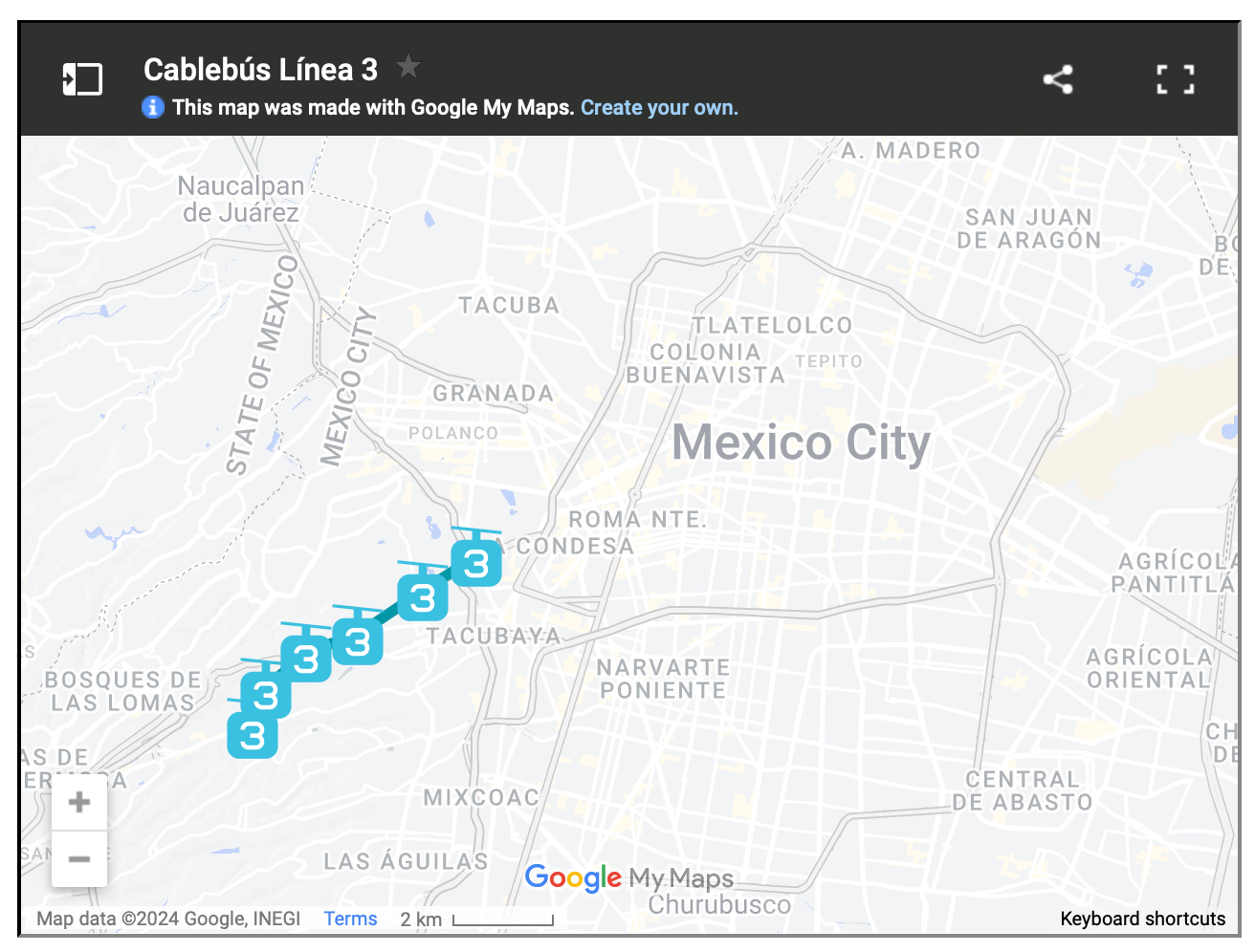
    For reasons like these, Mexico City has spent the last three years building three new cable car lines, the most recent of which opened just last month. The city now has the longest cable car line in the world. But more importantly, it has a new transit add-on that is moving up to 80,000 people per day.

    This isn’t as much as rail. But that’s okay. The point of these lines is to bring more people closer in so that they can then connect to more services and other mobility options. And to do it quickly. Three new lines in three years is impressive. And from the sounds of it, it has transformed many people’s lives for the better.

    Here are maps of the 3 lines, zoomed out a bit so that you can see how they fit into the city’s broader urban context:

  • Bordeaux’s tramway network

    I was very impressed by Bordeaux’s tramway network. It felt like no matter where you were in the city, there was a tram gracefully passing you by. Here’s a high-level summary of the system:

    • The network has 4 lines and a total route length of 77.5 km.
    • The first line opened in 2003.
    • The network has 130 stops, which crudely results in an average stop spacing of around 600 m.
    • The system pioneered ground-level power supply for the trains, which means no overhead wires. Supposedly this caused some issues upfront, but now it seems to be working just fine.
    • Most of the network runs on a dedicated right-of-way (en site propre). Meaning, the trains don’t compete with car traffic. Many of the lines are quite beautiful too – see above video.
    • In 2018, the network carried close to 100 million people. This is in a city of ~260k people and a metro area of ~1.4 million people (2020).

    The key differentiators for me are (1) the stop spacing and (2) the fact that most of the system runs on its own dedicated right-of-way. These are two reasons why Toronto’s streetcars perform so poorly. They stop too frequently. And most of the lines have to compete with traffic.

    So why bother? Walking can be faster.

    Bordeaux shows that — if you implement light rail correctly — you can actually move a ton people efficiently. With surface rail, you can also build out a robust network in a relatively short period of time.

    Twenty years isn’t that long in city-building years. It has already been 10 years since Toronto was first promised SmartTrack.

  • The Ontario Line is happening

    Yesterday afternoon, I took the 504 King streetcar from the Bloor-Dundas West mobility hub down to King & Bathurst to meet a friend at the Wheat Sheaf Tavern. In case you didn’t know, this is believed to be the oldest continually-operating pub in the city. It opened in 1849.

    My streetcar ride took an obscenely long time (over an hour) and so it was the wrong mobility choice for a peak summer afternoon. I should have biked. But once I did finally arrive at Toronto’s oldest pub, it was great to see all of the activity happening right at the intersection for the new King-Bathurst subway station (Ontario Line).

    I’m always a bit cynical when it comes to transit plans. Like, it’s hard for me to believe that something is actually happening. I’m still waiting for SmartTrack to open. So I need constant visual reminders like these:

    What you are seeing above is the northeast corner of the intersection, which is where one of the two station entrances will go. Naturally, the station platform and track itself are also aligned on a diagonal so as to minimize “significant construction impacts” to the Wheat Sheaf (southwest corner).

    This stop is also one of Infrastructure Ontario’s Transit-Oriented Communities, which means the intent is to have a private developer build things on top of the station. Directionally, this is, of course, the right approach. It didn’t happen on the Eglinton Crosstown line; but we know that the best way to maximize the value of transit investment is to combine it with smart land use planning (the rail + property model). Density is your friend.

    From what I could glean during my time on the patio at the Wheat Sheaf, all of this appears to be moving forward. And already today, there is a ton of foot traffic in the area — meaning the future transit station should do very well from a ridership perspective. Now we just need this line extended up to the Bloor-Dundas West mobility hub so that the 504 streetcar can be relieved of some of its duties.

    Station Plan/Rendering: Metrolinx and IO

  • Just give me the fastest option

    I had a dinner in the suburbs this evening. And so in the afternoon today, I opened up Google Maps to figure out how I was going to get there.

    I didn’t have my car with me — because I hate driving into the office — so in my mind, I was either going to take transit or take an Uber.

    These are the time estimates that Google gave me:

    It was going to take me over 4 hours to walk there. Over an hour to drive there. And 47 minutes to take the train there. Interestingly enough, cycling was also going to be faster than driving.

    As soon as I saw this, I shut down the app and decided I would take the train. All I was interested in was the absolute fastest option. And for me at that moment, it was the train.

    I recognize that this isn’t always the case. Sometimes driving is much faster than taking transit. It depends on a number of factors.

    But as a general rule, when it comes to big and dense cities, you really can’t beat trains and bikes for moving the greatest number of people, as quickly as possible.

  • Three ways to optimize investments in transit

    Sometimes I’ll hear people in Toronto talk pejoratively about all of the development that’s been happening at Yonge & Eglinton (in midtown). They’ll say it’s too much density.

    But then you come across charts like the ones above (source previously shared here) and you realize that this location is the only section along the new Eglinton Crosstown LRT line that is actually starting to have enough people.

    Based on 2021 Census data, there were about 40k people within 800m of the future Eglinton and Mount Pleasant stations. In contrast, there are many downtown stations along the Ontario Line (also under construction) with around 80k people.

    Why this is important is because if the objective is to get people to ride this new transit and collect a lot of fares, then the single most important factor is going to be the amount of people that live, work, and play adjacent to each station.

    Now, I’m not a transportation planner, but in my mind there are three simple ways to think and go about optimizing for this:

    1. You can look at where population densities are already high and then add new transit to service these densities. This is what is happening with the Ontario Line and it was long overdue. We know that ridership is going to be relatively high because of the chart at the top of this post.
    2. You can look at where there’s existing transit and then work to optimize the land uses around it. This is what we should be doing a better job of along the Bloor-Danforth line, where certain station areas have actually lost people over the last few decades. This is the opposite of what you want next to transit investments.
    3. Lastly, you can also proactively plan new transit while simultaneously encouraging more density. An example of this would be the Vaughan Metropolitan Centre (just north of Toronto). Extend the line and encourage growth. This is good. The only thing with this approach is that it can seem a bit misaligned if you’re currently failing at #1 and #2.

  • Walking back a transit decision

    I take the UP Express train into the office every day (here in Toronto). This is a rail service that we have spoken about many times over the years on this blog.

    It started as an airport link that was too expensive, but was then repriced so that more people would use it, and use it locally. It is now widely used by people like me. I don’t know the exact split, but in the mornings, it feels like majority commuters.

    Then on Monday of this week, the province announced that local service would be reduced from every 15 minutes to every 30 minutes. Supposedly this was in order to improve service between downtown and Pearson airport.

    Commuters immediately reacted. In fact, while riding the train on Tuesday morning, there was quite literally a guy beside me on the phone trying to complain to his local city councillor and MPP. A petition was also started on Monday that, at the time of writing this post, had close to 6,000 supporters.

    And then — some 24 hours after the initial announcement — the Minister of Transportation announced that the province would be walking back this service change and that he had “directed Metrolinx to not proceed.” Boom.

    As a daily rider, this selfishly makes me happy. But more importantly, I think it, once again, shows how quickly voices can get amplified in today’s world and how important good regional express rail is to our city. Clearly we need more of this!

    Sadly, it probably also shows that some people have no idea how lines like these are actually getting used. I have to believe that if anyone had looked closely at ridership and the split between local/airport, that this decision wouldn’t have been made in the first place.

  • Toronto’s King Street is not a transit corridor

    Back in 2016, the City of Toronto announced plans to run a transit-priority pilot on King Street in the downtown core. What this meant was that cars would be restricted to only certain movements and that streetcars would be given priority. This pilot was ultimately implemented in 2017 and, eventually, it was made permanent. Presumably because it was doing some good for transit flows. But just this week, new data was revealed showing that, in some cases, travel times today are worse (i.e. longer) than they were before the pilot:

    CityNews has learned that eastbound travel times from Bathurst to Jarvis during the evening rush hours averaged 19 to 26 minutes before the pilot program in 2017. The latest times show it is now worse with an average of 22 to 29 minutes.

    One way to look at this data would be to say, “okay, clearly this transit corridor thing isn’t working. Streetcar travel times have gotten worse. So why bother?” But I think the real answer is this: King Street hasn’t remained a transit corridor since the pilot. Many/most motorists continue to use it, even though some 22,000 tickets have apparently been issued since the pilot began. Here’s a random photo of King Street West taken from my office window one afternoon:

    So I think what this data is really saying is that we’ve probably done very little to actually improve transit flows on King Street since 2016, and that traffic has generally gotten worse during this time. This seems like a more accurate description to me. But of course, it doesn’t need to be this way. If really want King Street to be a transit corridor, we have the power to make that happen. It just means spending some money on public realm enhancements, gates, bollards, and the like. The choice is ours.

  • Line 1 to dinner

    On most days, I walk to the office. That is going to be changing later this summer, but what I’m about to say will still apply.

    Because I walk more often than I drive, whenever I have to go somewhere that necessitates a car and that obligates me to leave during the evening rush, the first thing I usually think to myself is “shit, it’s going to really suck getting out of downtown.”

    I have very little patience when it comes to sitting in traffic. So when I’m faced with this kind of situation, my mind immediately goes to: “okay Brandon, what are your other options here?”

    And this is exactly what happened this past Friday. I had a dinner up in Vaughan after work and I opted to take the subway to VMC station (the northern terminus of one of Toronto’s lines).

    It was actually my first time riding this new line extension and it was cool to see the area around the station. It’s not yet a 15-minute community, but I believe it can get there with some narrow streets and the right kind of ground floors.

    The entire trip took about 45 minutes, and I can tell you that on more than one occasion I thought to myself, “this is way better than sitting in traffic.”

  • US public transit ridership since March 2020

    Consider the following stat: 65% of all transit trips across the US in 2019 came from just 6 metro areas: New York, Boston, Chicago, San Francisco, Washington, DC, and Philadelphia. Not surprisingly, these are all places with dense and walkable urban centers. In other words, they have built environments that are conducive to the use of public transportation.

    While we know that more people working from home has been bad for transit and that agencies across the world are facing deep holes in their budget, I continue to come back to two things. One, we have not yet reached a post-pandemic equilibrium. We are still making our way back to the office. And two, the single most important thing when it comes to transit ridership is land use.

    If we want more people to take transit, then we need to build our cities accordingly. That means streets people actually want to walk on, and a lot more density.