
Daily insights for city builders, delivered every morning at 6 AM ET. I’m Brandon Donnelly — a Toronto-based real estate developer and founder of Globizen. I’ve been writing here since 2013.

Tag: transit

  • The Ontario Line is happening

    Yesterday afternoon, I took the 504 King streetcar from the Bloor-Dundas West mobility hub down to King & Bathurst to meet a friend at the Wheat Sheaf Tavern. In case you didn’t know, this is believed to be the oldest continually-operating pub in the city. It opened in 1849.

    My streetcar ride took an obscenely long time (over an hour) and so it was the wrong mobility choice for a peak summer afternoon. I should have biked. But once I did finally arrive at Toronto’s oldest pub, it was great to see all of the activity happening right at the intersection for the new King-Bathurst subway station (Ontario Line).

    I’m always a bit cynical when it comes to transit plans. Like, it’s hard for me to believe that something is actually happening. I’m still waiting for SmartTrack to open. So I need constant visual reminders like these:

    What you are seeing above is the northeast corner of the intersection, which is where one of the two station entrances will go. Naturally, the station platform and track itself are also aligned on a diagonal so as to minimize “significant construction impacts” to the Wheat Sheaf (southwest corner).

    This stop is also one of Infrastructure Ontario’s Transit-Oriented Communities, which means the intent is to have a private developer build things on top of the station. Directionally, this is, of course, the right approach. It didn’t happen on the Eglinton Crosstown line; but we know that the best way to maximize the value of transit investment is to combine it with smart land use planning (the rail + property model). Density is your friend.
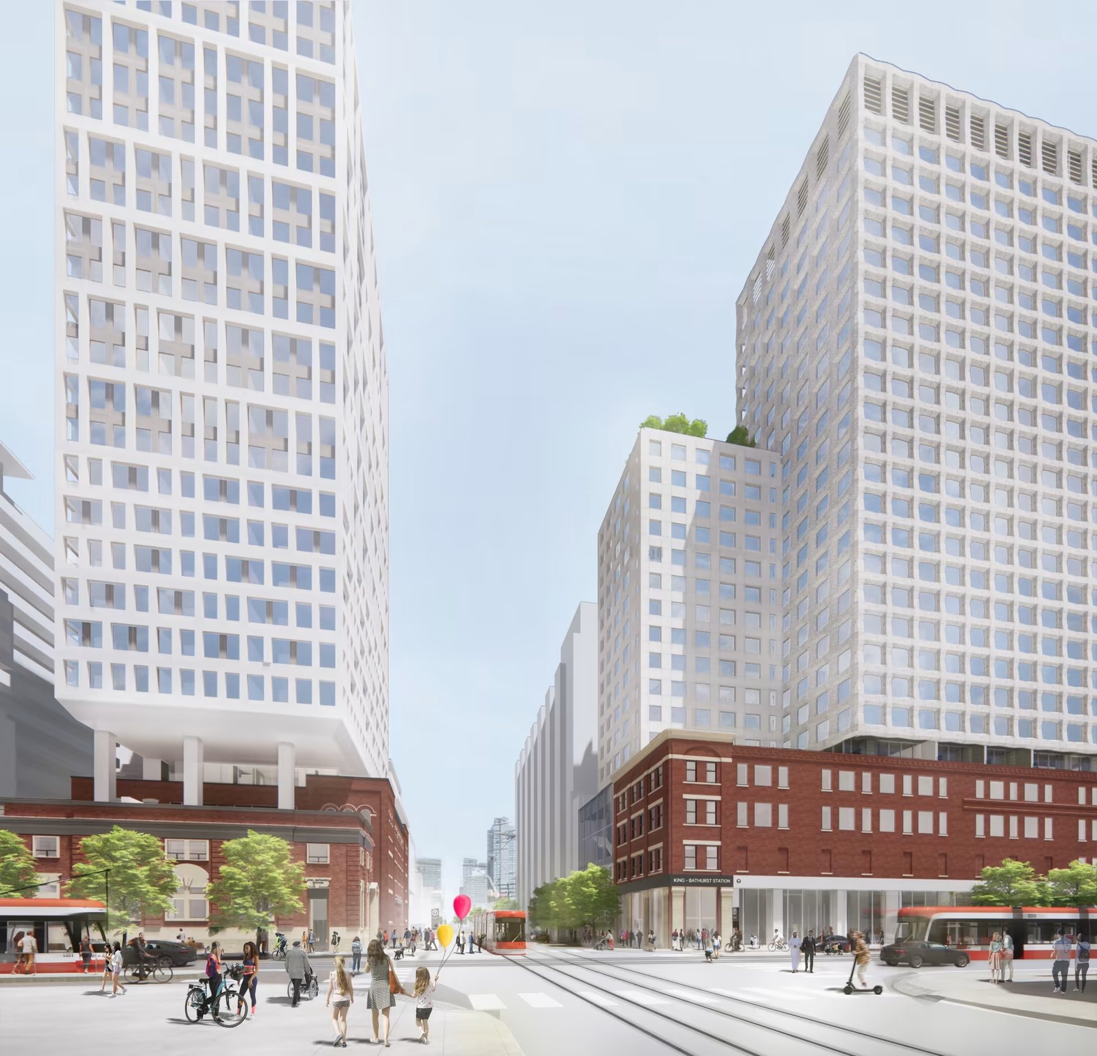
    From what I could glean during my time on the patio at the Wheat Sheaf, all of this appears to be moving forward. And already today, there is a ton of foot traffic in the area — meaning the future transit station should do very well from a ridership perspective. Now we just need this line extended up to the Bloor-Dundas West mobility hub so that the 504 streetcar can be relieved of some of its duties.

    Station Plan/Rendering: Metrolinx and IO

  • Just give me the fastest option

    I had a dinner in the suburbs this evening. And so in the afternoon today, I opened up Google Maps to figure out how I was going to get there.

    I didn’t have my car with me — because I hate driving into the office — so in my mind, I was either going to take transit or take an Uber.

    These are the time estimates that Google gave me:

    It was going to take me over 4 hours to walk there. Over an hour to drive there. And 47 minutes to take the train there. Interestingly enough, cycling was also going to be faster than driving.

    As soon as I saw this, I shut down the app and decided I would take the train. All I was interested in was the absolute fastest option. And for me at that moment, it was the train.

    I recognize that this isn’t always the case. Sometimes driving is much faster than taking transit. It depends on a number of factors.

    But as a general rule, when it comes to big and dense cities, you really can’t beat trains and bikes for moving the greatest number of people, as quickly as possible.

  • Three ways to optimize investments in transit

    Sometimes I’ll hear people in Toronto talk pejoratively about all of the development that’s been happening at Yonge & Eglinton (in midtown). They’ll say it’s too much density.

    But then you come across charts like the ones above (source previously shared here) and you realize that this location is the only section along the new Eglinton Crosstown LRT line that is actually starting to have enough people.

    Based on 2021 Census data, there were about 40k people within 800m of the future Eglinton and Mount Pleasant stations. In contrast, there are many downtown stations along the Ontario Line (also under construction) with around 80k people.

    Why this is important is because if the objective is to get people to ride this new transit and collect a lot of fares, then the single most important factor is going to be the amount of people that live, work, and play adjacent to each station.

    Now, I’m not a transportation planner, but in my mind there are three simple ways to think and go about optimizing for this:

    1. You can look at where population densities are already high and then add new transit to service these densities. This is what is happening with the Ontario Line and it was long overdue. We know that ridership is going to be relatively high because of the chart at the top of this post.
    2. You can look at where there’s existing transit and then work to optimize the land uses around it. This is what we should be doing a better job of along the Bloor-Danforth line, where certain station areas have actually lost people over the last few decades. This is the opposite of what you want next to transit investments.
    3. Lastly, you can also proactively plan new transit while simultaneously encouraging more density. An example of this would be the Vaughan Metropolitan Centre (just north of Toronto). Extend the line and encourage growth. This is good. The only thing with this approach is that it can seem a bit misaligned if you’re currently failing at #1 and #2.

  • Walking back a transit decision

    I take the UP Express train into the office every day (here in Toronto). This is a rail service that we have spoken about many times over the years on this blog.

    It started as an airport link that was too expensive, but was then repriced so that more people would use it, and use it locally. It is now widely used by people like me. I don’t know the exact split, but in the mornings, it feels like majority commuters.

    Then on Monday of this week, the province announced that local service would be reduced from every 15 minutes to every 30 minutes. Supposedly this was in order to improve service between downtown and Pearson airport.

    Commuters immediately reacted. In fact, while riding the train on Tuesday morning, there was quite literally a guy beside me on the phone trying to complain to his local city councillor and MPP. A petition was also started on Monday that, at the time of writing this post, had close to 6,000 supporters.

    And then — some 24 hours after the initial announcement — the Minister of Transportation announced that the province would be walking back this service change and that he had “directed Metrolinx to not proceed.” Boom.

    As a daily rider, this selfishly makes me happy. But more importantly, I think it, once again, shows how quickly voices can get amplified in today’s world and how important good regional express rail is to our city. Clearly we need more of this!

    Sadly, it probably also shows that some people have no idea how lines like these are actually getting used. I have to believe that if anyone had looked closely at ridership and the split between local/airport, that this decision wouldn’t have been made in the first place.

  • Toronto’s King Street is not a transit corridor

    Back in 2016, the City of Toronto announced plans to run a transit-priority pilot on King Street in the downtown core. What this meant was that cars would be restricted to only certain movements and that streetcars would be given priority. This pilot was ultimately implemented in 2017 and, eventually, it was made permanent. Presumably because it was doing some good for transit flows. But just this week, new data was revealed showing that, in some cases, travel times today are worse (i.e. longer) than they were before the pilot:

    CityNews has learned that eastbound travel times from Bathurst to Jarvis during the evening rush hours averaged 19 to 26 minutes before the pilot program in 2017. The latest times show it is now worse with an average of 22 to 29 minutes.

    One way to look at this data would be to say, “okay, clearly this transit corridor thing isn’t working. Streetcar travel times have gotten worse. So why bother?” But I think the real answer is this: King Street hasn’t remained a transit corridor since the pilot. Many/most motorists continue to use it, even though some 22,000 tickets have apparently been issued since the pilot began. Here’s a random photo of King Street West taken from my office window one afternoon:

    So I think what this data is really saying is that we’ve probably done very little to actually improve transit flows on King Street since 2016, and that traffic has generally gotten worse during this time. This seems like a more accurate description to me. But of course, it doesn’t need to be this way. If really want King Street to be a transit corridor, we have the power to make that happen. It just means spending some money on public realm enhancements, gates, bollards, and the like. The choice is ours.

  • Line 1 to dinner

    On most days, I walk to the office. That is going to be changing later this summer, but what I’m about to say will still apply.

    Because I walk more often than I drive, whenever I have to go somewhere that necessitates a car and that obligates me to leave during the evening rush, the first thing I usually think to myself is “shit, it’s going to really suck getting out of downtown.”

    I have very little patience when it comes to sitting in traffic. So when I’m faced with this kind of situation, my mind immediately goes to: “okay Brandon, what are your other options here?”

    And this is exactly what happened this past Friday. I had a dinner up in Vaughan after work and I opted to take the subway to VMC station (the northern terminus of one of Toronto’s lines).

    It was actually my first time riding this new line extension and it was cool to see the area around the station. It’s not yet a 15-minute community, but I believe it can get there with some narrow streets and the right kind of ground floors.

    The entire trip took about 45 minutes, and I can tell you that on more than one occasion I thought to myself, “this is way better than sitting in traffic.”

  • US public transit ridership since March 2020

    Consider the following stat: 65% of all transit trips across the US in 2019 came from just 6 metro areas: New York, Boston, Chicago, San Francisco, Washington, DC, and Philadelphia. Not surprisingly, these are all places with dense and walkable urban centers. In other words, they have built environments that are conducive to the use of public transportation.

    While we know that more people working from home has been bad for transit and that agencies across the world are facing deep holes in their budget, I continue to come back to two things. One, we have not yet reached a post-pandemic equilibrium. We are still making our way back to the office. And two, the single most important thing when it comes to transit ridership is land use.

    If we want more people to take transit, then we need to build our cities accordingly. That means streets people actually want to walk on, and a lot more density.

  • Warren Buffet doesn’t like crypto and streetcars

    I have a great deal of respect for Warren Buffet. Much of what I know (or think I know) about investing has come from listening to and watching him and his partner Charlie Munger. Surely they have got to be the most successful investors living today.

    But there are some things that I don’t always agree with them on. The first and most obvious one is crypto. Warren thinks it is speculative rat poison and I think it is the future of the internet. I understand where he is coming from in that it does not produce cash in the same way as say a farm or an apartment building. But that doesn’t mean it won’t have value.

    The second one, as I have learned today, is maybe streetcars. As a rule, Warren doesn’t typically engage in local politics. But he recently decided to break that rule through a letter he wrote to the editor of the Omaha World-Herald, lobbying against a new $306 million project that I believe is going ahead regardless.

    Here’s an excerpt from the letter:

    “Residents can be far better served by extended or more intensive service by the bus system,” Buffett wrote. “As population, commerce and desired destinations shift, a bus system can be re-engineered. Streetcars keep mindlessly rolling on, fuelled by large public subsidies. Mistakes are literally cast in cement.”

    I should, however, be clear that (1) I know nothing about Omaha and this streetcar project, and (2) “streetcars” can be nuanced. There are streetcars that compete with car traffic and have short station spacing, and there is light rail transit on its own dedicated tracks and with farther station spacing. One size does not fit all.

    Here in Toronto, we have lots of the former and they generally move you around at the slowest possible speeds. Sometimes it is faster to just walk. But we are also getting a new light rail line next year and that should move much faster. I can also tell you that when I worked in Dublin many years ago, I took their Luas to the office every day and loved it.

    Again, I don’t know the specifics of Omaha’s streetcar project. Maybe Warren is right or maybe he is wrong. And that’s why I was careful to say “maybe” above. But I do know that in the right urban contexts and when done well, I am a fan of light rail transit.

  • 10 years of contactless payments on London’s public transport

    I was having coffee this week with a self-described luddite and, after we ordered our coffees, he surprised me by pulling out his iPhone and initiating ApplePay. Knowing him and his general views on technology, I said, “I’m surprised that you of all people are now using ApplePay.” To which he responded, “I can’t believe it took me this long to start using it. It’s so convenient! I now barely ever pull out my wallet.” Yup, it is very convenient.

    It also just so happens that this month marks the 10 year anniversary of contactless payments on London’s public transport network. This meaning payment via a bank or credit card, and not via an Oyster card. In fact, part of the reason why London did this was because bus drivers were struggling with both having to give change and having to deal with people who didn’t have enough funds on their Oyster cards.

    So Transport for London (TfL) decided to spend £11 million, design and code the entire thing in-house, and then roll it out across the network starting in 2012. Apparently, adoption started off relatively slowly. At the end of 2013, only about 6 million journeys were made using contactless payments — this is against an initial projection of 25 million. But fast forward to today, and around 70% of all bus journeys are now contactless.

    What is also interesting about this is that TfL now licenses their contactless technology to other cities around the world. Here is a £15 million deal that was announced in 2016, which suggests that they could be generating a fairly respectable return on their initial investment. But aside from this, contactless payments are an obviously good way to onboard people onto public transport. There’s no special card. No lining up at a ticket kiosk. And yes, you can even use your phone.

    Photo by Tomas Anton Escobar on Unsplash

  • Shoes follow built form

    I have remarked this before, but I’ll say it again anyways: sneakers are very popular in Paris. Everybody seems to be wearing cool and colorful sneakers, regardless of what the rest of their outfit happens to look like.

    Full business suit? Why yes, you should be wearing cool sneakers.

    But why is that?

    Paris is a famously walkable city. At any given time, you’re on average just about 500m from the closest subway station. So my entirely unproven sneaker theory is this: shoes follow built form.

    If you build a city around people walking everywhere, one will ultimately choose the most appropriate kind of footwear.

    Photo: Rosa Bonheur sur Seine