
I’m late in writing this blog post because I was up in Collingwood for the day snowboarding. I’m exhausted, but I do have something to say.
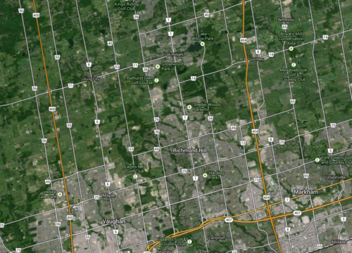
One of the things I always find interesting when I’m driving north of the city is how far Toronto’s major north-south streets extend. Go out to Aurora or Newmarket and you’ll still come across many familiar faces such as Jane, Keele, Dufferin, Bathurst and Yonge Street. And the distance between each of them is exactly the same as it is in the city: 2 kilometres.
This may not seem like much of a big deal, but have you ever wondered how this street grid was established?
These streets are actually concession roads. And they were used to subdivide undeveloped land in Upper and Lower Canada into a grid that could then be further subdivided into farming lots. Each square of the grid is 2 km x 2 km, or 1,000 acres.
Look at a map of the Greater Toronto Area and you’ll see it:
But what I find most intriguing about this grid system is that it was designed around farming—not our current use case. The intent was to further subdivide each 1,000 acre lot into smaller 100 acre farming lots. And these concession roads were for access—they weren’t city blocks.
By comparison, there’s another city that’s famously run off a regular street grid. You may have heard of it. It’s called New York. And its street grid was established in the Commissioner’s Plan of 1811. Some even go so far as to say that it’s “the single most important document in New York’s development.”
But New York’s grid is much different than the one I’m talking about. Because of its smaller scale (20 blocks a mile going north-south), New York’s was decidedly urban. It was meant for city building.
Now, in the case of Toronto, concession roads obviously never stopped us from developing a thriving city. We filled in each square to make them as urban as we needed them to be. But as planning ideals changed, so did the infilling of those squares. Our grid was flexible enough to accommodate everything from farm land to suburban subdivisions.
But I can’t help but wonder how the Greater Toronto Area would have turned out had we, quite simply, chosen a different size of square. What if instead of 2 km x 2 km, we had made them 1 km x 1 km? Or what if we made them even smaller? What would the Toronto region look like today?
Sometimes it may seem like a simple decision, but in reality the implications are huge.
