Daily insights for city builders, delivered every morning at 6 AM ET. I’m Brandon Donnelly — a Toronto-based real estate developer and founder of Globizen. I’ve been writing here since 2013.

Tag: public transit

  • What five global cities teach us about social mixing

    Here is an interesting study published in Nature Cities called “Hidden patterns of urban mixing across five global cities.” The study leverages individual-level travel data, covering over 200,000 residents in Boston, Chicago, Hong Kong, London, and São Paulo, to analyze the amount of social mixing that tends to occur across different socioeconomic groups within these cities. To be more precise, the study measures collocation among different segments — people within the same urban spaces at the same time.

    Two findings stood out to me.

    First, public transit is a key ingredient in increasing social mixing. It does this because it centralizes activity and delivers a broad cross-section of people to amenity-rich destinations, rather than encouraging decentralization. It is for this reason that “the gap in social mixing between low and high income is smaller in Hong Kong and London than in the other three cities.” Destination amenities explain 50-69% of individual social mixing levels, according to the study.

    Second, the study finds support for something known as the “second youth” hypothesis. This is a documented phenomenon where people, right after the typical retirement age (ages 65-74), exhibit an increase in social interaction and mixing. Another term for this is the Third Age, which is the active post-retirement period that people live after their Second Age (employment and family formation) and their First Age (childhood, education, and dependency). This makes sense given that retirement frees up time!

    Both of these findings (as well as the other ones in the report) offer lessons for city builders. Public transit and density are the great urban unifiers. They, quite literally, bring people together. At the same time, it’s a reminder that our challenge is to design our urban centres and public spaces for the full human lifecycle: young people, families, retirees living their best lives, and everyone else.

  • Mass transit with on-demand service

    Here’s what we know:

    In the mid-20th century, the US made a pivotal choice that shaped its cities, economy and lifestyle. It chose highways and cars over public transit. At the time, this seemed like the future: the freedom of the open road, the allure of suburban living, and the booming post-second world war economy all converged to push America towards a car-centric culture.

    The Federal-Aid Highway Act of 1956 cemented this vision, unleashing a highway system that encouraged suburban sprawl, fuelled the automotive industry and sidelined public transit. Rail systems were seen as relics of a slow, industrial-era technology ill-suited to America’s postwar aspirations. The car was king. 

    But this congested system is breaking. In 1950 about 30 per cent of the world’s population lived in cities. By 2030 this is expected to reach 60 per cent. Infrastructure cannot keep up with this growth. An increase in cars further reduces street capacity.

    What we don’t have a clear consensus on, though, is the path forward. Is it more highways? More public transit? More bike lanes? Or will autonomous vehicles finally arrive and bail us out? The answer will depend on who you ask.

    In this recent opinion piece, venture capitalist Vinod Khosla makes the case for something else: personal rapid transit systems (or PRT). Conveniently, he also happens to be an investor in one — a company called Glydways.

    The promise is an on-demand mass transit system that offers the convenience of a personal car, but with the capacities and price points of public transit. And it is based on small autonomous vehicles riding in their own dedicated lanes.

    Each lane only needs to be 1.5 meters wide, which is less than the 2.3 meters that the Dutch see as the ideal width of a one-way bike lane. And with this, the company claims that it can reach capacities of up to 10,800 people per hour.

    To further put this into perspective, the standard width of a two-way parking drive aisle here in Toronto is 6 meters. So this would mean that each drive aisle could, in theory, have 4 lanes dedicated to these “Glydcars.” That’s how narrow they are.

    Here’s a video of them in operation:

    This, of course, isn’t an entirely new idea. You might remember that Masdar City in Abu Dhabi claims to have opened the world’s first PRT system in 2010 — a 1.4 km line with only two stations. That said, Glydways has already been awarded three projects in the US. So for fun, I think I’ll keep an eye on them.

  • The longest cable car line in the world is in Mexico City

    Mexico City is all kinds of big. It is the largest metropolitan area in North America, the largest Spanish-speaking city, and broadly one of the largest megacities in the world. Because of this, it can be, you know, hard to move around.

    I remember visiting the city for the first time when I was in elementary school, and it standing out to me that everyone had one day of the week when they were simply not allowed to drive their car. It was/is a form of load balancing. Imagine that. (I don’t know if this is still the case, or if it’s even more stringent today.)

    I also remember visiting the city later on, when I was in grad school, and it standing out to me that their metro had women-only cars. This was and continues to be an attempt to try and minimize the amount of sexual harassment that takes place on transit. Again, it can be hard to move around Mexico City.

    The city’s latest solution is one that has found success in other Latin American cities, such as Medellin, and that is: cable cars. Relative to subway or light rail, they’re inexpensive. They’re also good at navigating steep terrain, and their stations can be inserted into dense urban areas. This includes working-class neighborhoods who might otherwise have very limited mobility options.

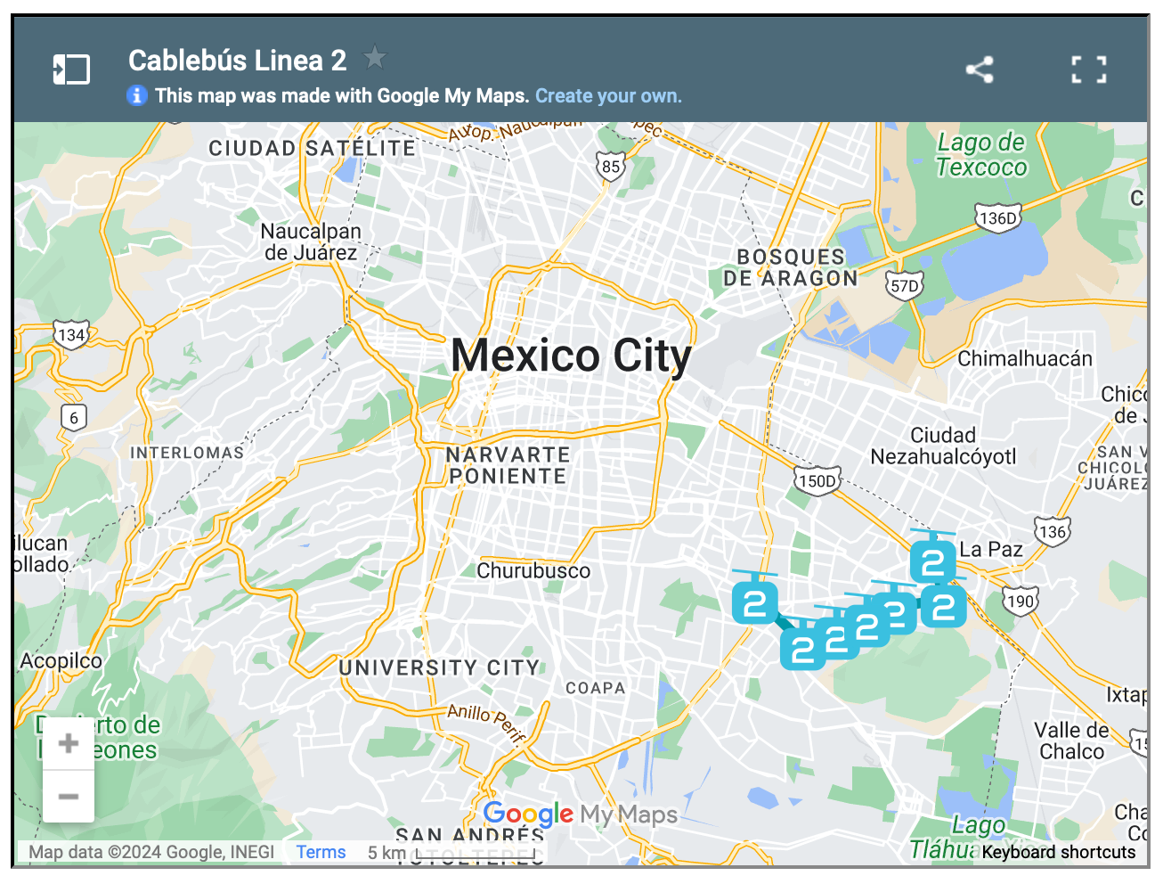
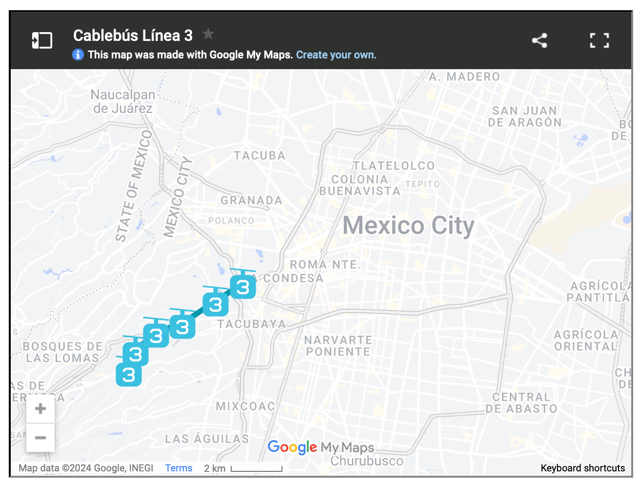
    For reasons like these, Mexico City has spent the last three years building three new cable car lines, the most recent of which opened just last month. The city now has the longest cable car line in the world. But more importantly, it has a new transit add-on that is moving up to 80,000 people per day.

    This isn’t as much as rail. But that’s okay. The point of these lines is to bring more people closer in so that they can then connect to more services and other mobility options. And to do it quickly. Three new lines in three years is impressive. And from the sounds of it, it has transformed many people’s lives for the better.

    Here are maps of the 3 lines, zoomed out a bit so that you can see how they fit into the city’s broader urban context:

  • Bordeaux’s tramway network

    I was very impressed by Bordeaux’s tramway network. It felt like no matter where you were in the city, there was a tram gracefully passing you by. Here’s a high-level summary of the system:

    • The network has 4 lines and a total route length of 77.5 km.
    • The first line opened in 2003.
    • The network has 130 stops, which crudely results in an average stop spacing of around 600 m.
    • The system pioneered ground-level power supply for the trains, which means no overhead wires. Supposedly this caused some issues upfront, but now it seems to be working just fine.
    • Most of the network runs on a dedicated right-of-way (en site propre). Meaning, the trains don’t compete with car traffic. Many of the lines are quite beautiful too – see above video.
    • In 2018, the network carried close to 100 million people. This is in a city of ~260k people and a metro area of ~1.4 million people (2020).

    The key differentiators for me are (1) the stop spacing and (2) the fact that most of the system runs on its own dedicated right-of-way. These are two reasons why Toronto’s streetcars perform so poorly. They stop too frequently. And most of the lines have to compete with traffic.

    So why bother? Walking can be faster.

    Bordeaux shows that — if you implement light rail correctly — you can actually move a ton people efficiently. With surface rail, you can also build out a robust network in a relatively short period of time.

    Twenty years isn’t that long in city-building years. It has already been 10 years since Toronto was first promised SmartTrack.

  • Nobody drives at the Olympics anymore

    One of the commitments that Paris made for this summer’s Olympics was ensure that every single competition venue was served and accessible by public transport. In fact, if you look on their website, it clearly says “no venues in the Paris region are accessible by motorized vehicles.”

    For those who attended, this seems to have worked out quite well. So much so that Los Angeles just made a similar commitment for the 2028 Olympic Games (excerpt from the New York Times):

    L.A. mayor Karen Bass said Saturday the city is working on expanding its public transportation system to hold a “no-car Games” in four years, which means spectators will have to take public transportation to all Olympic venues. To accomplish this, she added that L.A. will need more than 3,000 buses and plans to borrow them from around the U.S.

    Of course, the built environment of Los Angeles is slightly different than that of Paris’. One was built around the car, and the other was not. And I think the success of Paris 2024 shows how a robust public transport system is uniquely equipped to absorb significant demand shocks when needed.

    Here’s an excerpt from Le Monde talking about transit during the games:

    Not only was the audacious gamble of organizing the first Olympic Games completely accessible by low-carbon public transport, on bicycle and on foot successful. Not only was transportation to the many competition venues scattered around Paris and its surrounding region fluid. But the transit network and its agents also proved their ability to ensure, thanks to planned initiatives and adapted resources, fast, reliable and even pleasant travel. What’s more, the Paris Olympics offered the pleasing spectacle of a large city mostly freed, for a time, from the clutches and nuisances of automobile traffic.

    But regardless of built form, both of these examples represent one of the positive externalities associated with hosting the games. They force cities toward massive positive change, and that’s always a good thing.

  • Why do we choose traffic?

    Scott Stinson gets a lot right in this recent Toronto Star article about road pricing:

    There is a simple tool to combat traffic congestion that has been proven to be effective. There are real-world examples of where it has been deployed to great and long-lasting success. It’s called road pricing. And we seem to be deathly afraid of it.

    This is even if the benefits are real and measurable:

    Jonas Eliasson, director of travel accessibility at the Swedish Transport Administration, has first-hand experience with the effects of the congestion charge implemented in Stockholm in 2006. Public polling showed two-thirds of voters were against the road-pricing plan before it was introduced in a pilot program. A local politician called it the “most expensive way ever devised to commit political suicide.” But after it began, Stockholm traffic levels dropped by 25 per cent, more than double initial estimates. In a subsequent referendum, Stockholm residents voted to adopt the congestion charge permanently.

    There are lots of reasons why road pricing is commonly opposed, but at the end of the day, it works, and we know all too well — especially here in Toronto — that the status quo sucks:

    “Over the years, transportation economists and planners have pointed out that there really is no other solution to traffic congestion than more efficient pricing,” he said in an interview. “So every time somebody said ‘No, I don’t want road pricing or congestion pricing,’ they’re actually saying, ‘I want traffic congestion.’”

    I’ve been writing about this topic for almost as long as I’ve been writing this blog. So at this point, I think we just need to run a pilot. No more studies and reports. No more protracted debates.

    Let’s try it out and see how many people prefer (1) less traffic congestion and (2) more money for alternative modes of transport.

  • We’re far from full

    I tweeted this out yesterday:

    What I was getting at is that there’s lots of available room within our existing boundaries for infill housing. We are nowhere near full, despite what some people will tell you. In fact, most areas are not dense enough to properly support modes of transport that aren’t the car.

    Of course, there are a number of ways that one could be offended by a statement like this.

    One, you could argue that more density would make the city unlivable. Two, you could get into the chicken-and-egg game of whether a more expansive transit system is needed before allowing more density. Three, you could say that we already have enough zoned and unbuilt housing supply — so why do we need more? And I’m sure that there are many others that I’m not mentioning here.

    Density can be a counterintuitive feature for cities. It can actually make a place more livable by encouraging more amenities adjacent to where people live and work, and it can also reduce traffic congestion by empowering alternative forms of mobility. If the only reasonable way to get around is by car, then of course most people will drive.

    We also need to avoid the chicken-and-egg mental trap when it comes to mobility infrastructure. Land use and transportation always work hand in hand and need to be thought of and executed on simultaneously.

    Finally, the objection of already having lots of sites zoned for new housing is an enticing one. But zoned and delivered are two vastly different things. And the unfortunate reality is that there are a lot of zoned sites that won’t be able to develop in the short and medium terms because the market isn’t there. But that doesn’t mean that other housing typologies couldn’t be built.

    At the same time, we need move away from “cruise ships of urbanity.” Broadly speaking, Paris — to cite just one of many examples– is at least and on average about 4x denser than Toronto. And somehow, people still like living and visiting there.

  • Toronto’s King Street is not a transit corridor

    Back in 2016, the City of Toronto announced plans to run a transit-priority pilot on King Street in the downtown core. What this meant was that cars would be restricted to only certain movements and that streetcars would be given priority. This pilot was ultimately implemented in 2017 and, eventually, it was made permanent. Presumably because it was doing some good for transit flows. But just this week, new data was revealed showing that, in some cases, travel times today are worse (i.e. longer) than they were before the pilot:

    CityNews has learned that eastbound travel times from Bathurst to Jarvis during the evening rush hours averaged 19 to 26 minutes before the pilot program in 2017. The latest times show it is now worse with an average of 22 to 29 minutes.

    One way to look at this data would be to say, “okay, clearly this transit corridor thing isn’t working. Streetcar travel times have gotten worse. So why bother?” But I think the real answer is this: King Street hasn’t remained a transit corridor since the pilot. Many/most motorists continue to use it, even though some 22,000 tickets have apparently been issued since the pilot began. Here’s a random photo of King Street West taken from my office window one afternoon:

    So I think what this data is really saying is that we’ve probably done very little to actually improve transit flows on King Street since 2016, and that traffic has generally gotten worse during this time. This seems like a more accurate description to me. But of course, it doesn’t need to be this way. If really want King Street to be a transit corridor, we have the power to make that happen. It just means spending some money on public realm enhancements, gates, bollards, and the like. The choice is ours.

  • Phase one of Montreal’s REM is now open

    The first phase of Montreal’s new Réseau express métropolitain (or REM) just opened it up. It is a 17 km light-rail line that includes five stations running from Brossard in the south (A1 above) to Gare Centrale in downtown Montreal. Eventually this network — which is distinct from but connected to the city’s existing metro network operated by STM — will span 67 kilometers and have a total of 26 stations. To put this into perspective, Montreal’s current metro totals 69.2 kms. So this is a near doubling.

    As with most big city building projects, Montreal’s REM is being and will continue to be criticized. Back in 2016, the project had an estimated total project cost of $5.9 billion. By 2021, this number had increased to $6.9 billion. Today, who knows what the number will be. But it will be more. The reality is that everything went up, by a lot, over the last five years. During the pandemic, we were seeing 30-40% cost increases on some of our construction line items.

    What’s perhaps most noteworthy about this project is its delivery model. It is being delivered through a partnership with the the Caisse de dépôt et placement du Québec (CDPQ):

    Under the pact, the Caisse’s infrastructure arm is assuming $3.5-billion of the project’s $6.9-billion construction cost while Quebec is committing $1.28-billion and the Canada Infrastructure Bank is providing a $1.28-billion loan. The balance consists of a $295-million payment from Hydro-Québec for the line’s electrification, while the Autorité régionale de transport métropolitain, the transit authority for the Montreal region, is pledging $512-million.

    Provincial and local governments will provide continuing operating subsidies for the REM to make sure the Caisse earns its required return on the project, currently pegged at 8 to 9 per cent. The pension fund manager will get 72 cents for each passenger-kilometre travelled on the light rail system. Without such a subsidy, fares would climb to a level few passengers could afford.

    It’ll be interesting to see how this approach stands the test of time. As I understand it, CDPQ wants to continue building and operating transit in other cities around the world. I don’t know any of the specifics other than what I have read online. But from the outside, things seem to be working. The first phase of the REM broke ground in April 2018, and the opening ceremony was held this month (July 2023). That’s basically warp speed in transit timelines.

    Map: Montreal REM

  • Line 1 to dinner

    On most days, I walk to the office. That is going to be changing later this summer, but what I’m about to say will still apply.

    Because I walk more often than I drive, whenever I have to go somewhere that necessitates a car and that obligates me to leave during the evening rush, the first thing I usually think to myself is “shit, it’s going to really suck getting out of downtown.”

    I have very little patience when it comes to sitting in traffic. So when I’m faced with this kind of situation, my mind immediately goes to: “okay Brandon, what are your other options here?”

    And this is exactly what happened this past Friday. I had a dinner up in Vaughan after work and I opted to take the subway to VMC station (the northern terminus of one of Toronto’s lines).

    It was actually my first time riding this new line extension and it was cool to see the area around the station. It’s not yet a 15-minute community, but I believe it can get there with some narrow streets and the right kind of ground floors.

    The entire trip took about 45 minutes, and I can tell you that on more than one occasion I thought to myself, “this is way better than sitting in traffic.”