Daily insights for city builders, delivered every morning at 6 AM ET. I’m Brandon Donnelly — a Toronto-based real estate developer and founder of Globizen. I’ve been writing here since 2013.

Tag: public space

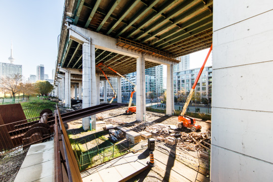
  • Project: Under Gardiner — Re-imagining Toronto’s urban infrastructure

    image

    If you’ve been reading this blog since the summer, you might remember that there was a period of time where I wrote incessantly about the removal of the eastern portion of Toronto’s elevated Gardiner Expressway.

    Ultimately City Council didn’t vote the way I believe we should have. But I remain hopeful that somehow we will manage to do the right thing and replace it with a surface boulevard. Now – before the east waterfront gets developed – is the right time to make that happen.

    However, the western portion of the Gardiner Expressway is a different story. The adjacent area is already developed and it is unlikely that this highway is going anywhere any time soon. So for the foreseeable future, we are stuck with it.

    And if we are stuck with it then we should make the absolute best of it – even celebrate it. Which is why Toronto is buzzing right now with the news that a 1.75 km stretch under the western portion of the Gardiner Expressway will be remade into a vibrant public space by 2017. This is thanks to a generous $25 million private donation. (Is that enough money?)

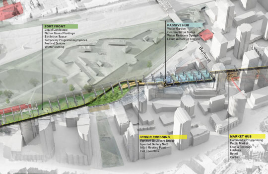
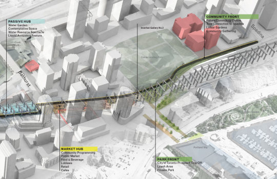
    Here’s the overall programming strategy, going from west to east (via undergardiner.com):
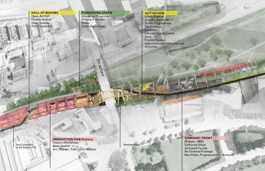
    imageimageimage

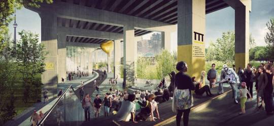
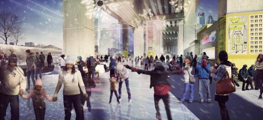
    And here are two renderings:

    imageimage

    The first phase is expected to run from Strachan Avenue in the west all the way to Spadina Avenue in the east. That is what is shown above.

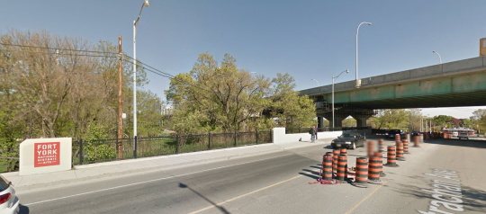
    Two key elements include a grand stair at Strachan Avenue, which looks like this today (via Google Streetview):
    image

    And a pedestrian bridge over Fort York Boulevard, which looks like this today:
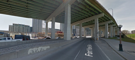
    image

    All of this doesn’t change my opinion of the Gardiner East, but I do believe that this is an incredibly exciting opportunity for the city. Today the space under the Gardiner is a void in our public realm.

    I also think it could be quite interesting to have these two opposing urban conditions along the central waterfront. A linear underpass park in the west and an open air boulevard in the east.

    It’s also exciting to see private money step up. It goes to show you that there is no shortage of passionate city builders in this town.

    Top image courtesy of Harry Choi Photography.
  • The day modern architecture died

    image

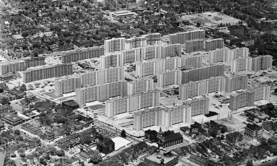
    In 1956, a large 57 acre urban renewal project was completed in St. Louis. It consisted of 33 apartment buildings, each 11 storeys tall. The entire complex was known as Pruitt-Igoe.

    Early residents seemed to really like the buildings. The first tenant, Frankie Mae Raglin, called it the “nicest place she’d ever had.” 

    But 16 years later in 1972, the first 3 buildings within Pruitt-Igoe were demolished. And in 1977, architectural historian Charles Jencks proclaimed that the day Pruitt-Igoe was demolished was the day that modern architecture had officially died.

    The modernist dream had failed. Architecture had failed us. Segregated “towers in a park” was not the way to socially engineer away poverty and slums from our cities. 

    This is the narrative that we have told ourselves, not only in St. Louis, but in cities all around the world.

    But was it really all architecture’s fault?

    Stuyvesant Town in New York (80 acres) shares many of the same architectural ideals that Pruitt-Igoe embodied and it seems to be holding up just fine. The same could be said for Lafayette Park in Detroit (46 acres), which is probably more telling given what the city witnessed in the years following 1956 – the year Lafayette Park was completed.

    So the reality is far more complex.

    Between 1950 and 1970, St. Louis lost about 30% of its population. Coming on the end, Pruitt-Igoe had a vacancy rate of 88%. Racial tensions were also surging. Here’s how the American Institute of Architects put it back in 2012:

    Pruitt-Igoe was built during a tumultuous time in U.S. race relations in a city with an intense history of racial segregation. Pruitt and Igoe were designed as separate, racially segregated projects: Pruitt for African-American residents, Igoe for whites. As the towers were going up, the Supreme Court’s Brown v. Board of Education decision banned segregation. Faced with the possibility of living next to African-American neighbors in an integrated Pruitt-Igoe, white residents moved out en masse, exacerbating Pruitt-Igoe’s vacancy problems.

    So while most cities rightfully would’t dare build in the spirit of Pruitt-Igoe today, this was not a strictly architectural problem. There is always an underlying social, political, and economic environment. And unfortunately architecture, alone, cannot solve everything. 

    If you’re interested in this topic, I recommend you check out a paper by Katharine G. Bristol called, The Pruitt-Igoe Myth.

    Image by Bettmann/Corbis via The Guardian

  • Name your laneway

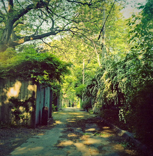
    Photograph Urban Explorer by Andrew B. on 500px

    Urban Explorer by Andrew B. on 500px

    Laneway housing is becoming an incredibly popular topic here in Toronto. Lots of people seem to be interested in building, or least living in a compact ground-related laneway dwelling. 

    A big part of this, I think, has to do with affordability (or the perception of affordability). A lot of people want to live in a central urban neighborhood, but it has simply gotten both expensive and difficult to secure low-rise housing. Here’s an example of a young couple in Toronto who went door-to-door in their desperation to find a house.

    I believe that laneway housing has the potential to be a more affordable low-rise housing solution in this city, as well as in many other cities around the world who have a similar urban condition. But today, at least here, it’s not that way.

    Since the City of Toronto does not officially support laneway housing, it would be an uphill to get one approved and you need to be willing to put a significant amount of money at-risk in order to try. It’s unfortunate, but that’s the reality today.

    I’m certain that will change. But it will take a bit more pioneering. The Laneway Project, which I advise, is working to change the way Toronto thinks about its laneways and I know that there are many other small entrepreneurs working on doing the same.

    One of the first things that will need to happen is that we’re going to need to name our laneways. Some of them are already named, but many of them are not. And while this may not seem like a big deal, it is. For laneway housing to become a reality, they will need to have addresses and we will need to think of our laneways as legitimate streets.

    Recently The Laneway Project published a how-to guide called: How to Name Your Laneway. So if you’re interested in laneways and laneway housing here in Toronto, I would encourage you to give it a read and then try and get your local laneway named.

  • The psychological benefits of third places

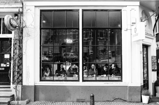
    Photograph - by rinatus (rinatus) on 500px

    – by rinatus (rinatus) on 500px

    Today I’m thinking about extraversion and third places within cities.

    As many of you I’m sure know, the idea of a third place is that after your home (first place) and your work (second place), cities have what are known as third places. This could be a coffee shop, a barber shop, or a public space (to name only a few examples).

    This, of course, is not a new idea. For decades people have been arguing that third places are essential for establishing a sense of community, place, and belonging. In fact, this emphasis on third place is one of the ingredients that made Starbucks so successful.

    But with the rise of the internet and freelancing, third places are becoming even more important. That’s why coffee shops have become arguably the best example of a third place in today’s cities. They’ve even become the new second place for some (many?) people.

    But beyond just a place to meet and socialize, I’ve been thinking today (while I was at a third place) about the psychological benefits of these spaces.

    For example:

    One of the key differences between extraverts and introverts is where they draw their energy from. For introverts, they tend to draw it from within. In order to recharge, they often feel the need to retreat and be left alone. Extroverts, on the other hand, draw their energy from the outside world. They charge up by being around other people.

    When I was completing my MBA at Rotman, one of the things they had us do at the beginning and at the end of the program was complete the Myers-Brigg personality test

    In both instances, I was as extroverted as they come (I am consistently what is known as an ENTJ). And from experience, I can say that I definitely feed off the energy of other people.

    But the interesting thing about this – to tie both of these topics back together – is that there appears to be a clear correlation between extroversion and a preference for living in urban centers. And given what I just said, that probably makes sense to you.

    So if you too classify yourself as an extroverted person, then third places are more than just a busy coffee shop or a vibrant public space. They are where you derive your energy and where you feel alive. And that’s a pretty powerful thing in my view.

  • Nominate your laneway for transformation

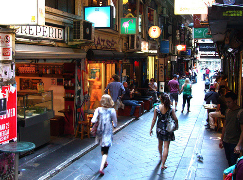
    image

    Some of you might be aware that I’m involved with a non-profit group here in Toronto called The Laneway Project

    Our mission is to transform the city’s under-utilized laneways into safe, vibrant, and people-friendly spaces – which is something that has been done with a lot of success in other parts of the world (see Melbourne above).

    Today I’m excited to announce two things.

    First, the group has received funding from the Ontario Trillium Foundation. This is great news because it’s obviously a lot easier to execute on a mission when you have some resources behind you.

    And that ties into the second announcement. 

    The funding received from the OTF is going to be used for 2 laneway transformation projects here in Toronto. Think of them as pilot projects that will help to reorient Torontonians into thinking about laneways as viable public spaces and to demonstrate that this group is about real action.

    Once the 2 laneways have been chosen, The Laneway Project will work with those local communities to come up with a vision and then an implementation plan. But before that can happen, there needs to be 2 laneways.

    So if you’re a community group, resident association, business improvement area, or some other passionate group, now is your chance to nominate your laneway. Get in touch with The Laneway Project before February 7th, 2015 by clicking here.

    Image: Melbourne Laneway via Flickr

  • 19 Duncan Street bought for $47 million

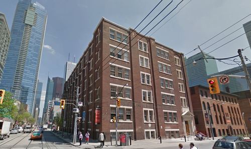
    image

    Last week it was announced that Allied Properties and Westbank have acquired 19 Duncan Street in Toronto for $47 million.

    The property sits at the southeast corner of Adelaide Street West and Duncan Street (shown above), and includes an existing 61,911 square foot (GLA) office building, 36 surface parking spots, and a laneway (it was specifically called out in the press release).

    The plan is to restore the existing heritage building, as well as build additional retail space, office space, and rental apartments. Given the nature of this site and the team behind it, I have high hopes that it will end up a remarkable development project.

    It’s interesting to see the continuing interest in rental apartments here in Toronto – which is something I’ve written about before. Up until recently, the development community had almost zero interest in purpose built rental apartment buildings. Now they’re coming back in fashion.

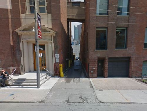
    But the other piece that’s interesting to me is the laneway. Below is a photo from Google streetview, showing what I believe is the laneway that the press release is referring to.

    image

    As many of you know, I’m involved in a non-profit here in Toronto called The Laneway Project (advisory role only). We want to transform Toronto’s underutilized laneways. And this strikes me as a perfect opportunity to do something really exciting at the corner of Adelaide and Duncan in the Entertainment District.

    So if the new owners have any interest in things that are exciting, I would encourage them to get in touch with me or one of the founders of The Laneway Project.

  • What the largest real estate development project in the United States looks like

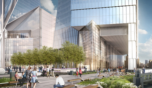
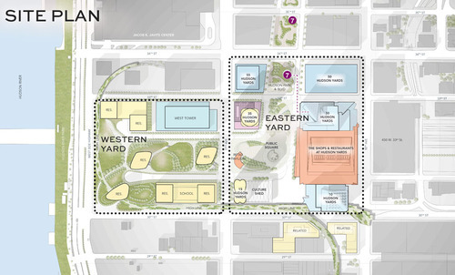
    Urban Land Magazine recently published an interesting article on the Hudson Yards project in New York, which is the largest private real estate development project ever undertaken in the United States. Click here for the article. Thanks to my friend Evan Schlecker for passing it along. It’s a good read.

    The project is being co-developed by Related out of New York and Oxford Properties out of Toronto, and when it’s all said and done, it’ll be over 17 million square feet of commercial and residential space. It’s a $20 billion development project. 

    But beyond just being massive and epic, there are a bunch of other things that make this project unique. You can read about them all in Urban Land, but I’d like to share a few snippets with you all here:

    The first is about the project’s placement on top of a rail yard:

    In order to make use of a site already occupied by a working rail yard—including more than 30 tracks for the Long Island Rail Road and three train tunnels, with a fourth under construction—most of the development will be built atop two steel-and-concrete platforms. That base, and the buildings on it, will be supported by hundreds of concrete-filled caissons, which will be drilled between the rail lines into the bedrock.

    Because the location of the tracks and tunnels limits the placement of caissons, only 38 percent of the site can be used to support buildings.

    The second is about the project’s use of technology:

    Beyond that, a vast number of sensors embedded in the site’s infrastructure will collect mountains of data on everything from temperature and air quality to pedestrian and vehicle traffic. That information, which will be scrutinized in real time by managers in an effort to fine-tune Hudson Yards’ operation, will also be shared with New York University (NYU) researchers, who will turn Hudson Yards into a laboratory for studying urban life and finding ways to improve its quality.

    And the last one is about how it interfaces with the High Line (click here if you don’t know what that is):

    Pedersen [of Kohn Pedersen Fox Associates] found an intriguing way to address the building’s surroundings. He allowed the High Line—a public park built on a historic freight rail line elevated above the West Side—to penetrate underneath the tower through a 60-foot-long (18.3 m) public passageway, so that the building will interact with the park and its visitors. Inside the building, a dramatic atrium “becomes the terminus of the High Line as it moves from south to north,” he says.

    So there are a lot of interesting and exciting things going on with this project. What’s amazing though is how “vertical” this community will be. You have rail lines below grade. Platforms on top. Retail at grade and across multiple levels. And an elevated linear park cutting through the buildings. Not every city can make this work. New York can.

    Images: Hudson Yards New York

  • The new Regent Park

    Yesterday morning I went for a swim at the new Regent Park Aquatic Centre. I used to swim regularly when I was in grad school in the US, but it fell off when I moved back to Toronto and there wasn’t a convenient place for me to walk to. Having to drive to a gym or to a pool can really cut hurt how often you’re able to go.

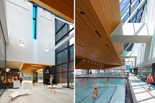
    In any case, the pool was fantastic. On the west side of it are glass sliding doors that face the park. And since yesterday was such a beautiful day, they were all open while everyone was swimming lanes. The wooden ceiling also gives the space a nice, warm feel.

    The biggest surprise for me though was the universal change rooms. I had never been in a co-ed change room before – or one that was completely open and visible to the pool (there are small private rooms so you can actually change). For families, it makes a lot of sense. Everyone can go in together and it’s easy to watch your kids in the pool from within the change room.

    After my swim, I rode my bike around Regent Park and tweeted this out:

    What’s happening in Regent Park is incredibly exciting. To me, it feels like a return to the fundamentals of city building. They’ve reconnected the old street grid – which had previously been removed to create the old “towers in a park” scheme – and they’re clearly working towards a proper urban neighborhood with retail at grade and buildings pushed right up against the street.

    A big measure of success, though, will be how animated the streets become and how well the retail does. Because all of that isn’t quite there yet. But we’re on our way. And already I feel like we’re about to forget what the old Regent Park used to be like. Toronto may have lived with that neighborhood for over 60 years, but future generations will barely know it existed.

    Image: Shaigil

    //platform.twitter.com/widgets.js

  • The Laneway Project: Engaging In-Between Spaces

    A few months ago I was asked to join the advisory committee of a small Toronto-based non-profit called The Laneway Project. The goal of the organization is to create a network of vibrant, safe, and people-oriented public spaces throughout the city by leveraging our extensive, yet underutilized, network of existing laneways. 

    If you’re a regular reader of ATC, you’ll know that I have a huge interest in laneways and laneway housing. So not surprisingly, I was thrilled to be a part of the project.

    It’s still early days, but we are getting ready to actively fund raise. And we’ve also just announced our first event. It’s called Engaging In-Between Spaces, and it’s going to consist of 5 speakers giving super fast presentations on the potential of Toronto’s laneways (think 20 seconds a slide type of thing). There will also be a moderated discussion, and drinks, I’m sure. So mark your calendars for the evening of Thursday, November 20th – more details to follow.

    In the interim, you can show your love for Toronto’s laneways by subscribing to The Laneway Project. Happy Friday everyone!

    Image: Flickr

  • How are you being shaped?

    image

    “We shape the cities, and then our cities shape us.” That’s one of my favorite lines from the documentary The Human Scale, featuring Danish architect and urban designer Jan Gehl. I like it because I don’t think many of us think enough about the way in which the built environment – that we create – ultimately goes on to influence the way we live our lives.

    One of the most interesting connections for me is the link between urban form and public health. There’s been a lot of talk over the years about how suburban sprawl is, or might be, making us fat (among other things). We’ve created environments that are only navigable by cars and that has forced many of us into sedentary lifestyles. We sit in our cars, and then we sit in our offices.

    So today I’d like to conduct a bit of a poll. If you’d like to participate, please share the following 3 things in the comment section below: 1) your city, 2) the type of neighborhood you live in (urban, suburban, rural, etc.), and 3) the amount of time you spend walking or doing something active on an average day.

    Here’s me:

    I live downtown Toronto in the St. Lawrence Market neighborhood (urban). I take the subway to work and the station is a 10 minute walk from my place. So as a bare minimum, I spend at least 20 minutes a day walking. But since I also walk to do most of my regular errands, and since my gym is another 10 minute walk from my place, I’d say I average a good 30-45 minutes of walking each day.

    Now it’s your turn 🙂

    This is a pretty crude survey, but with the advent of things like smartwatches and health monitors, I think we’ll soon have lots of great data on the ways in which our cities might shape our health.

    Image: The Economist