Daily insights for city builders, delivered every morning at 6 AM ET. I’m Brandon Donnelly — a Toronto-based real estate developer and founder of Globizen. I’ve been writing here since 2013.

Search results for: “light rail”

  • Learning from King Street

    Toronto is now a week into the King Street Transit Pilot.

    It’s still early days and transit guru Steve Munro hasn’t yet published any before and after route performance. He will. But already the sentiment seems to be clear: This shit is working. There are many recounts of people’s commute times being more than cut in half. 

    As somebody who walks this stretch of King every day, this isn’t surprising to me. There has been a dramatic reduction in the number of cars on the street.

    What is perhaps surprising is that none of the surrounding streets seem to be any busier. I would like to see the data, but it feels as if most of the cars have simply disappeared. Are more people now taking transit? Has this been your impression?

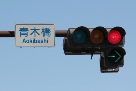
    Of course, the pilot isn’t perfect. What is not working are the signs that tell drivers they can’t drive through most of the intersections (only turn right). The circular green lights confuse them or they simply don’t care. 

    There have been suggestions for better signals, such as this one:

    image

    And if the pilot in its current incarnation does stick, I am sure there will be many additional improvements like this one made. But even at this early stage, Toronto is calling the pilot a “transit miracle.”

    When City Council approved the pilot in the summer it had a preliminary cost estimate of $1.5 million. (Figure excludes the lost parking revenue associated with removing approximately 180 on-street parking spaces).

    This is a relatively minuscule amount considering it has had an immediate impact, basically overnight, on the commute times of the 65,000 or so people who use this line every day.

    And it feels even more minuscule when you consider that our Scarborough Subway extension is expected to cost $3.35+ billion to build and only service around 64,000 people a day when you look far into the future – 2031 to be exact.

    The lesson here on King Street should be that light rail and surface transit routes can move lots of people very efficiently and cost effectively when you empower them to do precisely that.

  • Detroit tests new QLINE streetcar

    Detroit has started testing its new streetcars on Woodward Avenue. Quicken Loans bought the naming rights to the line, so it’s now officially called the QLINE. If you’re British, this name probably won’t instil feelings of rapidity.

    Here’s a recent tweet from M1-Rail (click here if it doesn’t show up below):

    //platform.twitter.com/widgets.js

    Note how the train is running curbside.

    There’s lots of debate about the economic benefits of streetcar/LRT over other transit solutions such as BRT. But if you’re a regular reader of this blog, you’ll probably know that I am a supporter of light rail.

    In the case of Detroit, I also think there’s symbolic importance to bringing back light rail to the core of the city. The last Detroit streetcar was shut down in 1956.

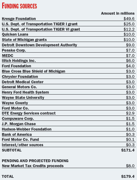
    It’s also worth mentioning how the streetcar line was funded. Below is a breakdown of funding sources dated 2014.

    image

    There may have been some changes since then, but it’s positive to see the public and private sectors come together, alongside a large infusion of philanthropic money (The Kresge Foundation).

    Many of the companies on the above list sponsored individual stations. The cost to do so was $3 million, which is why you see that number show up a few times. Compuware and JP Morgan Chase shared a station at $1.5 million each.

    Is this a transit funding model worth replicating?

  • The Scarborough Subway Extension is a mistake

    Last weekend over dinner, a friend of mine asked me what I thought about the Scarborough Subway Extension debate going on in Toronto right now. Costs are coming in higher than initially projected and the usual back and forth is taking place. Transit blogger Steve Munro has a good post on this called Spinning a Tale in Scarborough.

    I haven’t written much about the Scarborough Subway, but I do have a strong opinion. I believe it’s a mistake. I am not saying that we shouldn’t be building higher order transit in Scarborough – we absolutely should – but it does not need to be an expensive subway line. There are more sensible solutions.

    Here are a few things to consider:

    Light rail transit (LRT) does not equal streetcar. As an avid user of the King streetcar, I’ll be the first to admit that something needs to be done to address the city’s busiest streetcar routes. They are broken. But this is not what was being previously contemplated for Scarborough. True LRT – which Toronto does not yet have – is far more effective at moving people.

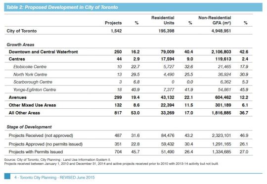
    Scarborough Centre is seeing almost no new residential and commercial development. In fact, the “Centres” in general are not seeing much development. The largest share is happening downtown, along the central waterfront, and along the “Avenues.” We shouldn’t ignore this when making our investment decisions. Transit and built form go hand in hand. 

    I also do not buy the argument that we are building this subway in anticipation of demand 50 or 100 years from now. We are not in a position to be proactive about our infrastructure. We are desperately playing catch up and there are already lots of high growth and high density areas in the city which today are completely underserved by higher order transit. 

    Finally, a new subway line with low ridership will mean higher operating cost subsidies to keep it afloat. And at the rate that Scarborough Centre is growing today, this would likely continue for many years into the future. Not only is this debate about spending money today, it is about spending money well in the future, month after month.

    So let’s be clear: the Scarborough Subway Extension debate is about politics. It is not about transportation planning.

  • Rethinking the backyard from Seattle to Toronto

    RobCasey iphone lorens house by Rob Casey on 500px.com

    https://500px.com/embed.js

    The Urbanist recently published a guest post, called Let Us Build Backyard Cottages, that sounds a lot like a post I wrote a few years ago, called Why It’s Next to Impossible to Get a Laneway House Built in Toronto.

    It’s the same story: buy house; see opportunity to build low-cost well-designed backyard cottage (or laneway house); discover the countless obstacles in front of you; give up until the land use policies become more favorable.

    Here’s the Seattle version of the story (via The Urbanist):

    I bought my home in 2014 with the intent of building a backyard cottage on the property. The property is a mere 4,080 square feet, with a large flat backyard that is mostly wasted space. The plan was to buy a small, prefabricated, and super-insulated (to Passive House standards) house. We would install it and move into it while we brought the main house up to Passive House standards as well, adding insulation and ventilation. We would then move into the main house while my parents (who are currently living on the East Coast, and want to move closer to us) move into the backyard cottage.

    Unfortunately, Seattle’s backyard cottage requirements proved too onerous for us to move forward with building one. The requirement of an additional parking space was a bit irritating (especially considering that my family lives car-free near the future Roosevelt light rail station), despite the fact that we do technically have two parking spaces. But more frustrating than that, it was the owner-occupancy requirement that made us scrap our backyard cottage plans.

    What I find interesting about all of this is that the same narrative is happening in multiple cities, from Seattle to Toronto. That, again, suggests to me that change is likely inevitable. Especially since Seattle seems further ahead in this regard compared to Toronto. Change is happening.

    Of course, there are differences between accessory dwelling units (what The Urbanist wrote about) and independent laneway housing (what I wrote about). But I would classify them as being in the same family of urban change.

    Most North American cities are clinging to a specific kind of single family housing typology. I can appreciate why. But I believe that there will be a tipping point.

    I’m not sure that this year will be the year. Which is why I didn’t include laneway housing in my list of 10 city building predictions for 2016. But I think it will happen in the shorter term.

  • Guest Post: For whom the road tolls?

    For those of who were following Architect This City during the Gardiner Expressway East debate here in Toronto, you might remember that Darren Davis (transport planner with Auckland Transport) wrote a guest post called, Three minutes that rule the world – Will demolishing the Gardiner East actually make traffic worse?

    It was an incredibly popular post at the time, so I’m thrilled that Darren volunteered to do another one on road tolls. This is a topic that I’m very interested in and have written about a few times. Road pricing, as you’ll see below, puts us in a bit of a chicken-and-egg situation. But sooner or later I think we will need to get our head around it, as will many other cities.

    I hope you enjoy today’s post. Thanks again Darren.

    ——————————-

    A recent post on Architect This City, The Tragedy of the Commons, raised a fundamental but all too often forgotten point about transportation: That in networks where the price of use doesn’t change when demand changes, there is no effective mechanism to manage that demand.

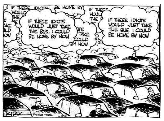
    Because there is no incentive to act in the public good, we often act in what we perceive to be our own personal interest, which is often the antithesis of the public interest. And remember that if we are driving, we are traffic. So often people will sit fuming in their cars in the midst of congestion with thoughts like in this cartoon. But of course with unpriced roads, there is no real price signal to these drivers to consider taking the bus.
    In a world where time is money, we are constantly berated about the economic costs of congestion. In 2011, the Toronto Board of Trade estimated that congestion in the Toronto region alone cost the regional economy $6 billion a year, rising to an estimated $15 billion in 2031 should no action be taken. More recent research by the CD Howe Institute pegs this figure at up to $11 billion.

    Given these sorts of eye-watering figures, one might be tempted to think that car drivers, and in particular the goods industry, would be flinging their wallets open at the chance to buy their way out of congestion. And in fact Toronto has the 407 Express Toll Route which has elements of variable road pricing. However, while the 407 ETR carries around 350,000 vehicles per day, price increases have been matters of controversy. It provides some ability for those who can afford it to bypass Toronto’s notorious traffic congestion, but its fundamental weakness is that it’s just one road in one of North America’s largest city-regions.

    Similar stand-alone efforts to address congestion in Metro Vancouver with tolled routes, such as the Port Mann Bridge on the Trans-Canada Highway and the Golden Ears Bridge, have fallen well short of their projected traffic volumes, while nearby untolled bridges such as the Patullo Bridge are heavily congested. We have a similar experience in New Zealand where our two tolls roads, with car tolls of $2 and $2.20 respectively, experience diversion rates of up to 30% to the alternative but substantially longer and slower free routes.

    This brings up a fundamental paradox: Congestion costs the economy a fortune and congestion is a top-of-mind frustration, yet people seem reluctant to pay even comparatively small amounts to bypass congestion.

    For example, the City of Toronto’s Roundtable on Gridlock & Traffic Congestion in February 2014 came up with the usual shopping list of “transportation systems management” responses – improved management of curbside space and construction projects; synchronized traffic signal phasing; better traveller information and improved incident response. While these are all worthwhile responses, they only improve system operation at the margins. Encouraging greater use of public transit was the very last recommendation and there was not a single mention of charging or pricing as a tool to address congestion. And the feverish activity continues with a hackathon called TrafficJam on October 2 – 4, 2015 with the goal of fixing Toronto’s traffic woes.
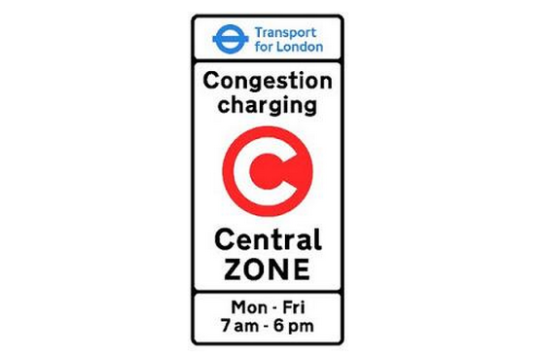
    The very few cities that have actually had significant success at reducing traffic congestion – notably Singapore, London and Stockholm – have done this through cordon-based congestion pricing wherein if you pass the cordon, you pay the congestion charge. Entering central London on a weekday between 7am and 6pm will set you back a cool £11.50 ($C23.30). From 2003 to 2013, about £1.2 billion ($C2.42 billion) of congestion charge revenue has been invested in public transport, road and bridge improvements and walking and cycling, of which £960 million ($C1.94 billion) was for bus improvements. These measures have included significant road space reallocation to improve conditions for pedestrians, cyclists, public transit and the urban realm.

    The latest Travel in London report states that “Over the 10-year period from 2003, total trips have increased by 11.4 per cent, with particularly notable increases of 52.3 per cent in rail trips and 32.0 per cent in Underground and DLR [Docklands Light Railway] trips, with cycle trips (as main mode) increasing by 53.9 per cent. Car driver trips decreased by 12.7 per cent over the same period” (my emphasis).

    One interesting insight is that Stockholm trialed congestion charging and then reverted to business as usual of unpriced roads in advance of a referendum on congestion pricing. This gave Stockholmers a clear sense of the difference in traffic congestion and was crucial in supporting a yes vote in the referendum.

    Stockholm has experienced a permanent reduction in traffic of about 20% across the toll cordon and congestion decreased by 30 – 50% – which demonstrates that traffic volume reductions have a disproportionately positive impact on congestion. About half of the “disappearing” drivers changed to transit, the rest to other alternatives such as different departure times and destinations and taking fewer trips.

    For more on Stockholm, I suggest reading the Tools of Change case study on Stockholm Congestion Pricing.
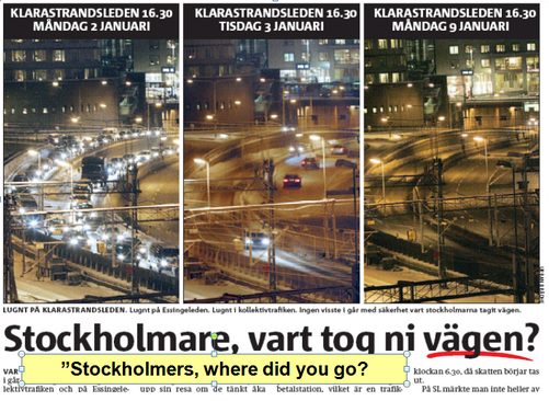
    Before and after congestion charge photos of traffic levels in Stockholm

    While this sounds very promising, congestion charging has significant equity implications and requires upfront investment to provide people who either choose to or can no longer afford to drive with transportation alternatives. Both Stockholm and London invested very heavily in public transit in advance of implementing congestion charging.

    And this brings up a big issue for Toronto. 

    For congestion charging to have a meaningful impact on congestion without stifling economic activity or impeding people’s ability to move around, the core capacity of Toronto’s transit system would need to be addressed first. In particular the Yonge Line capacity enhancements, Metrolinx’s Regional Express Rail and most likely the Downtown Relief Line would need to be in place to provide both capacity and choice for people who either needed or wanted a travel alternative to any congestion charge.  This would mean that Metrolinx’s Big Move might need to get even bigger.

    Disclaimer: The author of the above post is an employee of Auckland Transport, however, the views, or opinions expressed in this post are personal to the author and do not necessarily represent the views of Auckland Transport, its management or employees. Auckland Transport is not responsible for, and disclaims any and all liability for the content of the article.

  • The case for planning transit around minimum population densities

    Photograph Blitz by Tristan O'Tierney on 500px

    Blitz by Tristan O’Tierney on 500px

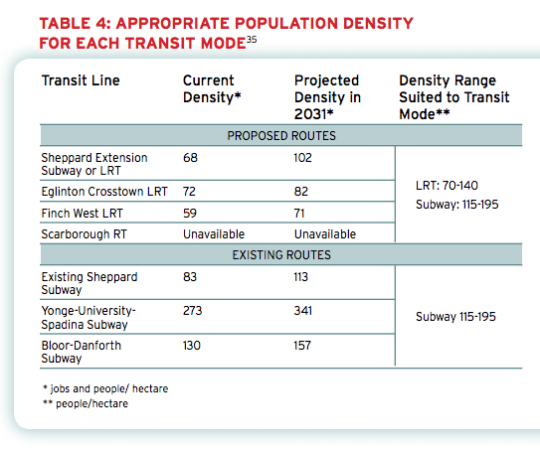
    Back in 2011, the The Pembina Institute published a report called, Building transit where we need it. And in it they quite clearly outlined the population densities that are needed to make various types of transit investment cost effective.

    For subway they specify a minimum population density of 115 people per hectare and for light rail (LRT) they specify a minimum population density of 70 people per hectare. 

    And the reason for this is because there’s a strong correlation between population density (i.e. land use) and transit ridership. The two go hand in hand and should not be decoupled. If population densities are too low (as they are, for example, along the Sheppard subway line here in Toronto), people don’t take transit. They drive.

    Here’s a chart from the report showing the current and projected population densities for Toronto’s existing and proposed routes (keep in mind this is from 2011).

    image

    So what does this chart tell us?

    • Subways don’t make a lot of sense in many parts of the city. LRT will do just fine.
    • The Sheppard subway line is an under-utilized asset. Even by 2031 we’ll barely be reaching the requisite population densities.
    • The Bloor-Danforth corridor could use more intensification.
    • The Yonge-University-Spadina line is going to need to relief.

    Unfortunately, transit decisions are often made based on politics instead of data. And that results in subways in places that don’t make a lot of sense. That’s unfortunate because it means less riders, less revenue, and more subsidies.

    The other challenge with running subways through low density neighborhoods is that it then creates tension when the city and developers go to intensify those neighborhoods through transit-oriented development. (See #DensityCreep.)

    But if we’re going to be fiscally irresponsible about where we deploy our transit capital, the least we could do is upzone the surrounding areas and impose minimum population densities. 

    In fact, here’s what I think we should do: Land use should be bundled with the transit decision. 

    Instead of asking where the subway station should go, we should be asking where the subway station should go and all the density needed to bring the area up to a certain minimum population density. And if that second criteria for whatever reason can’t be met, then we don’t build the line. 

    I wonder if we framed the question in this way if it would change where subway lines get approved. What do you think?

  • Driverless cars, urban mobility, and Toronto’s Gardiner Expressway

    image

    About a week ago I wrote a post questioning what driverless cars will mean for cities. I ended by saying that that it feels as if we’re going to see increasing tension between private and public transport.

    What I meant by that was simply that conventional notions around private car use are going to change. And ultimately that is going to mean that we need to rethink public transport and how that fits into a broader urban mobility framework.

    What do I mean by this?

    The International Transport Forum at the OECD recently published a fascinating report called, Urban Mobility System Upgrade: How shared self-driving cars could change city traffic. And it deals with exactly the sorts of things I am thinking about.

    The study looked of what might happen when all cars become self-driving in a mid-sized European city (specifically Lisbon, Portugal). They leveraged existing transportation data from the city, but replaced 100% of the human powered cars with two types of self-driving cars: TaxiBots and AutoVots.

    TaxiBots were driverless cars that would be shared with multiple people at the same time. In other words, they were a kind of pseudo-public transit. And AutoVots we’re your more conventional private taxi. They picked up one person at a time.

    So, what did they find?

    In the first scenario, they combined their TaxiBots and AutoVots with public transit (light rail) and discovered that the same number of people could be moved around with only 10% of the cars currently on the road. That’s a 90% reduction!

    They also found that the city needed 20% less on-street parking and 80% less off-street parking since driverless cars don’t need to sit idle waiting for a driver.

    In the second scenario, they removed mass transit from the equation. And in this instance they found that the city was still able to get around, but with an 80% reduction in the number of cars on the road. Remarkably, it also led to a 10% reduction in rush hour commute times.

    These are pretty profound changes. Reducing the number of cars on the road by 80-90% is a significant change. 

    But it’s also why I’ve been thinking about the tension between private and public transport. As we get better at optimizing “cars” (their definition will change), what becomes the role of true public transit?

    Ultimately, I think what will happen is a blurring of the two. In the example above, the TaxiBots served basically as small scale public transit. But that does not necessarily mean that true mass transit will become irrelevant. We’re just going to need to rethink how the entire mobility network fits together.

    I’d now like to bring this discussion back to Toronto for a minute.

    As many of you probably know from this blog, Toronto is on the cusp of deciding what to do with the eastern portion of the Gardiner Expressway (an elevated highway that runs across the downtown waterfront). It will go to City Council next month. 

    I firmly believe that we should remove it, but there many people who believe we shouldn’t. The main objection seems to be that the traffic projections indicate that removing it could make commuting into downtown – by car – 3 to 5 minutes longer by 2031

    By today’s standards, I believe this concern represents an outdated way of thinking about cities and urban mobility. Adding more lanes is like loosening your belt to deal with obesity. However, it gets even worse when you think about urban mobility in the context of this post.

    Given the profound transportation changes that are currently underway, I think there’s a strong likelihood that the Gardiner projections we have today will be completely wrong by 2031. I don’t know know for sure, but I’m guessing the models don’t account for the efficiencies being created by driverless cars and peer-to-peer networks.

    In other words, I am suggesting that those 3 to 5 minutes could prove to be a red herring. The relevant question should be: Which decision will allow Toronto to build the absolute best waterfront in the world? And in my opinion that leads to removing the Gardiner East.

    If you feel similarly, I would encourage you to write your local City Councillor.

  • More thoughts on driverless cars

    image

    If you’re a regular reader of Architect This City, you’ll know that I’m a big supporter of public transit. And that’s because, as far as I can tell, it’s the most efficient way of moving lots of people around a big city.

    But more and more I’ve been thinking about how technology might change, or even disrupt, this school of thought. Which is why when I wrote this post a few days ago, I was careful to say that private cars aren’t the mobility answer. Because in reality, cars likely aren’t going to go away. We’re just going to use them differently.

    Here are the two things I’m thinking about most:

    1. Driverless cars

    I’ve written about driverless cars before in terms of how they might be used as a form of public transit. But I think it’s worth revisiting them for a moment. There are lots of driverless car critics out there and they usually fixate on the fact that a car is still a car, whether or not you happen to be driving it. It still takes up the same amount of space in our cities. Or does it?

    The key thing to keep in mind is that when we’re not longer driving the vehicle, it opens up lots of different possibilities in terms of how they might be used and also how they might be designed. I was watching this fireside chat with the founders of Google the other night and, for them, driverless cars offer the possibility of solving two big problems: traffic and parking.

    We know that parking takes up a lot space in our cities. But that’s really symptomatic of the fact that the utilization rate for most people’s cars is incredibly low. Most of the time a car is sitting parked and idle. But with driverless cars, they’ll be able to drop you off at your destination and then continue on to pick up their next ride–thereby minimizing the need for all that parking.

    This would bring the utilization rate way up for each car, which would also minimize the number of absolute cars that we’d need to have in our cities to move everybody around. Of course, this would mean that we’d be sharing cars. People wouldn’t own cars; they would be an on-demand service.

    2. Networked vehicles

    This brings us to my second point: driverless cars will be networked cars. Again, I’ve written about this before, but I specifically wanted to raise it again because of a new service that Lyft just launched in San Francisco called Lyft Line.

    The way it works is simple. You input where you’re going and Lyft will match you up with others who are going to more or less the same destination. The routes get shared and this brings down the costs to everyday use. It runs on the same principles as the on-demand minibuses I wrote about in Helsinki.

    But if you combine this with driverless cars, you’re starting to get at something incredibly interesting. Now all of sudden you’re getting the door-to-door convenience of private cars with many of the efficiencies of public transit.

    So in my mind, it’s very possible that platforms like Uber, Hailo, and Lyft could became major infrastructure backbones in a world of driverless cars. And if you think about it in this context, then I don’t think the valuations for these companies should seem all that surprising. These are potentially huge innovations.

    In the end, I don’t know how this will all shake out. I don’t think anybody does. I believe that strong public infrastructure (such as subways, light rail, and so on) will still be needed in big cities, but I’m starting to think that mobile apps and driverless cars will also form a big part of how we get around. Probably more so than most people think today.

    Image: Flickr

  • Do you love or hate streetcars?

    image

    Tonight I saw one of Toronto’s new streetcars cruising down King Street. They’re still in test mode and the first batch won’t go into operation until this August, but every now and then you’ll see one circulating around the city. This was the first one I’d seen in person.

    If you’re a transit geek or urbanist, you’re probably excited about the arrival of these new streetcars. But I know that there are a lot of people who aren’t. They hate streetcars and they think of them as basically rolling stop signs on our congested downtown streets. And since these new streetcars are even longer than our existing ones, they’re worried they’ll just make the situation worse.

    Personally, I think that streetcars mixed into traffic is generally pretty inefficient. But I know that surface light rail has the potential, when executed properly, to be a cost-effective and sustainable way of efficiently moving lots of people around a city. When I lived in Dublin I took the Luas every day. It was great.

    So I’m curious to hear from you. What do you think of Toronto’s new streetcars? Let me know in the comment section below.

  • Every street can’t be everything to everyone

    Yesterday I spoke about why Toronto shouldn’t be so quick to dismiss streetcars and light rail. Today, I’d like to talk about some of the hard decisions we need to face if we really want to get our city moving.

    Toronto is a city of neighborhoods and small main streets–at least in the areas where our streetcars live. Streets such as King and Queen are only 4 lanes. And the problem we’re facing is that we’re trying to accommodate every single use case on them: cars, on-street parking, cyclists and streetcars. But in doing so, we’ve made the experience terrible for everybody. Streetcars move at a snail’s pace, drivers are frustrated by the lumbering streetcars, cyclists fear for their life driving by parked cars (doors can swing open at any time), and so on.

    And with the rise of downtown shoulder neighborhoods such as Liberty Village, King West, the Distillery District and the soon to be complete West Don Lands, the strain on our east-west corridors is only going to get worse–much worse, in fact. Already the King streetcar is the busiest streetcar route in the city, moving almost 60,000 people per day. That’s more than the (under utilized) Sheppard subway line.

    What I hope is clear to the ATC community though, is that the answer isn’t uniformly the car. We can’t have every single resident from Parkdale to Leslieville hopping into their car and driving downtown to their office at Yonge & King. It ain’t going to work. And so we’re going to need to make some difficult decisions about how we’re going to get our city moving on the backbone of transit.

    Sure the downtown relief subway line (screw the politics I’m attaching it to downtown) would be the ideal solution to connecting our emerging shoulder neighborhoods, but that’s not going to happen overnight. And so how do we improve the efficiency of what we already have? First, we need to accept the fact that every street isn’t going to be everything to everyone at all times. We need to choose who we want to optimize for.

    So here’s an idea that’s been floated many times before but never acted upon: let’s get rid of cars on King St and Queen St in the core during rush hour.

    This would give our streetcars the room to efficiently move people across downtown, minimizing the dreaded “bunching up” that occurs as a result of traffic congestion. It would make transit a reliable choice and there are ways to pilot it. But let’s be clear: this is not about being anti-car. It’s about optimizing uses and getting people moving. Cars would continue to get priority on Richmond St and Adelaide St, and transit riders (as well cyclists) would get priority on King and Queen.

    Of course, the Rob Ford viewpoint would say that we should be optimizing all streets for cars and getting the streetcars completely out of the way. But if that’s the approach we want to take, then we’re building the wrong kind of city. We shouldn’t be focused on intensifying and creating new inner city neighborhoods, because that only tips the scale in favor of transit. Instead, we should be focused on decentralization.

    But that’s what not we’re doing. We’re intensifying our city to the point that we’re now faced with a number of difficult–yet enviable–decisions about how we’re going to live and how we’re going to move around in the future. We’re a city in transition.

    Our mission here should be to figure out how to move people around the city as efficiently possible. Let’s put politics aside and recognize that time is one of our most precious resources. And when we put people in lumbering streetcars and debilitating traffic jams, we’re completely squandering that resource. It hurts productivity and it hurts our overall prosperity as a global city.

    There’s a place for subways, streetcars, buses, bikes and cars in our city. So let’s just get on with making them all work.