Daily insights for city builders, delivered every morning at 6 AM ET. I’m Brandon Donnelly — a Toronto-based real estate developer and founder of Globizen. I’ve been writing here since 2013.

Search results for: “light rail”

  • Why light rail isn’t a waste of money

    Last weekend a friend of mine sent me an article from The Economist talking about why trams, streetcars, and light rail are a waste of money. The argument is basically that steetcars are expensive, less efficient, and that – despite North America’s renewed interest in them – we should instead be spending our scarce public dollars on more buses.

    Here’s a snippet from the article:

    …but cash spent on streetcars displaces spending on other, more cost-effective forms of public transport like buses, which offer cheaper and more-efficient service but are considerably less sexy. The capital cost per mile of a streetcar is between $30m and $75m, while a rapid bus service costs anywhere between $3m and $30m, according to the American Public Transportation Association.

    Now, there’s no question that buse routes are initially cheaper to implement. You don’t have track to build. But I don’t agree that the cost structure is quite that simple if you consider the number of people you need to move in your city. I struggle to see buses as a more efficient service.

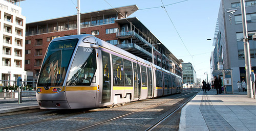
    The big difference between modern light rail and buses is capacity. Toronto’s new streetcars will move about 3 times as many people as your typical bus. So you’d need to triple the number of buses and triple the number of drivers – adding to your labor costs – if you want to have a chance at moving the same number of people. 

    Streetcars are also electric, which means they run on a renewable energy source. We’re in the process of making this switch with private transport, so why go backwards when it comes to public transport? You can certainly run electric buses as well, but then you’re building overhead power lines and bringing up your initial costs.

    I think the challenge is that when people think of light rail, they think of slow lumbering streetcars. I agree that many of these lines are inefficient and I’ve written about it. But there are a number of ways to implement light rail. And when done well it can efficiently move a lot of people for costs that are far less than a subway.

    Image: Aecom

  • There’s no light rail in Toronto

    Next City published an interesting article this morning on the politics behind Rob Ford’s subway obsession. I encourage you to have a read if you’re interested in politics, transit and/or the increasing polarization of North American cities (core vs. suburbs). It’s called Canada’s Strangest Straphanger.

    There are a number of great take-aways from the article, but I’d like to highlight one that I’m not sure many Torontonians realize: There’s currently no light rail (LRT) in the city. We have streetcars, of course. But no light rail. There’s a difference.

    Here’s an exert from Next City:

    “It is true that most people in Scarborough don’t want a light rail. They want a subway, and the reason they want it is that there is no light rail in Toronto,” says Jay Young, SSHRC postdoctoral fellow in the Department of History at McMaster University in Hamilton, Ontario. “We just have streetcars and subways and they think light rail is a streetcar, when actually it’s very close to a subway in terms of having its own right of way.”

    This may seem like semantics, but it’s not. Again, one difference is that light rail has its own right of way and streetcars compete with vehicular traffic. The other significant difference is station spacing. Streetcars stops are spaced similar to bus stops, which let’s say averages around 250m. LRT stations on the other hand are often in the range of 400-600m. This makes them similar to subways.

    It’s for this reason that even though the St Clair streetcar has its own right of way, I would not personally consider it a true LRT. As someone who lived in midtown for over 3 years, I can tell you that the stations are way too close together and that it’s highly inefficient during peak times – much like the rest of our streetcar network.

    Given the constant debates going on this city about light rail vs. subways, I think it’s important that we’re clear on definitions. Light rail has the potential to be an effective (read: cheaper and faster) way of delivering rapid transit to a greater number of people in the city. Before we dismiss that proposition, let’s please understand what it is.

  • Are short-haul flights on the way out?

    May 19, 2026 · View original


    Jet fuel costs have nearly doubled since the US and Israel attacked Iran in February. This is obviously straining the overall economics of air travel, but the most impacted segment is the one that has always been tenuous: short-haul flights.

    As I understand it, airlines generally prefer flights that are at least 2 hours long. Takeoff and landing consume the most fuel, and add a lot of wear and tear on a plane’s equipment, so you want a long enough flight to amortize these costs. This is why for the 10 years spanning 2016 to 2026, US flights spanning less than 250 miles declined by 11% — the largest drop of any route length.

    Now, in some cases, these short-haul flights are simply necessary loss leaders. For example, the flight from Milwaukee to Chicago is comically short. It’s only about 70 miles, translating into an actual cruising time of around 20 minutes. But it’s an important route for connecting passengers and the overall hub-and-spoke airline model.

    This also makes it slightly harder for rail to effectively compete, because you need to solve for two clear passenger demands (again, assuming they’re connecting): (1) people leaving Milwaukee will want to check their bags at the point of departure and (2) they don’t want to arrive downtown, they want to arrive at the airport for their connecting flight.

    That said, both of these wants are solvable. Hong Kong, for instance, allows in-town check-in where passengers drop their bags downtown before boarding the airport train. This is particularly convenient if you have to check out of your hotel and need to rid yourself of your luggage until you arrive at your final destination.

    Very cool, so what’s my point?

    I mention all this because if short-haul flights are the flight segment that airlines don’t love to operate, then it only strengthens the opportunity for high-speed rail to fill this gap in the market and become a seamless component of overall global mobility.

    Here in Canada, the obvious opportunity is the Toronto-Montreal corridor. This is arguably the single best opportunity in North America when you consider its geography, construction viability (lots of undeveloped land to lay new track), and ability to replace short-haul flights. The broader Windsor-Quebec City corridor is also, as we know, the densest part of Canada with roughly 50% of our entire population.

    But the overall opportunity is twofold: it will service origin-destination travel and it will connect Toronto and Montreal as global airport hubs. In fact, this is one of the stated reasons for why Air Canada joined the high-speed Alto project as a core consortium partner:

    > Connections with other modes of transport, such as rail or bus, are part of the solutions the company is already developing to offer the most relevant mobility option, responding in a sustainable way to the specific needs of each of its customers. In the longer term, the contribution of its expertise to the Cadence team will enable the airline to contribute to the harmonious integration of a future intercity rail network with existing airport hubs in the Quebec-Windsor corridor, for the benefit of all travellers.

    Here’s a specific example. Montreal largely serves as Canada’s direct gateway to France’s secondary cities, Francophone Africa, and the Mediterranean. So if you live in Toronto and want to fly to Marseille or Algiers or Mallorca, you are going to connect in Montreal (or connect across the Atlantic somewhere in Europe).

    The multi-modal train option would include an in-town baggage check at Union Station in Toronto, a 3-hour train ride to Montreal, a seamless rail connection from Gare Centrale to YUL (with the REM airport train set to open in 2027), and then your flight to Europe or Africa.

    The overall travel time should be comparable, except in the high-speed rail option you’d have more uninterrupted time to work, watch a movie, or sleep. And now that Air Canada gets to rid itself of its less profitable (or unprofitable?) short-haul flights, it should have the margin to aggressively market these tickets.

    If this customer experience is designed properly — with one booking, competitive fares, clean transfers, and convenient baggage handling — it will quickly dominate the market. We know this because it’s already working in Europe.


    Cover photo by 7 on Unsplash

  • The case for elevated rail

    March 1, 2026 · View original


    There is a school of thought that elevated rail is bad, or at least suboptimal, for cities. The thinking is that it’s a visual blight, it’s noisy, it disconnects neighbourhoods, and it can even reduce surrounding real estate values. Having a train passing directly in front of your window is admittedly less ideal than not having a train passing directly in front of your window.

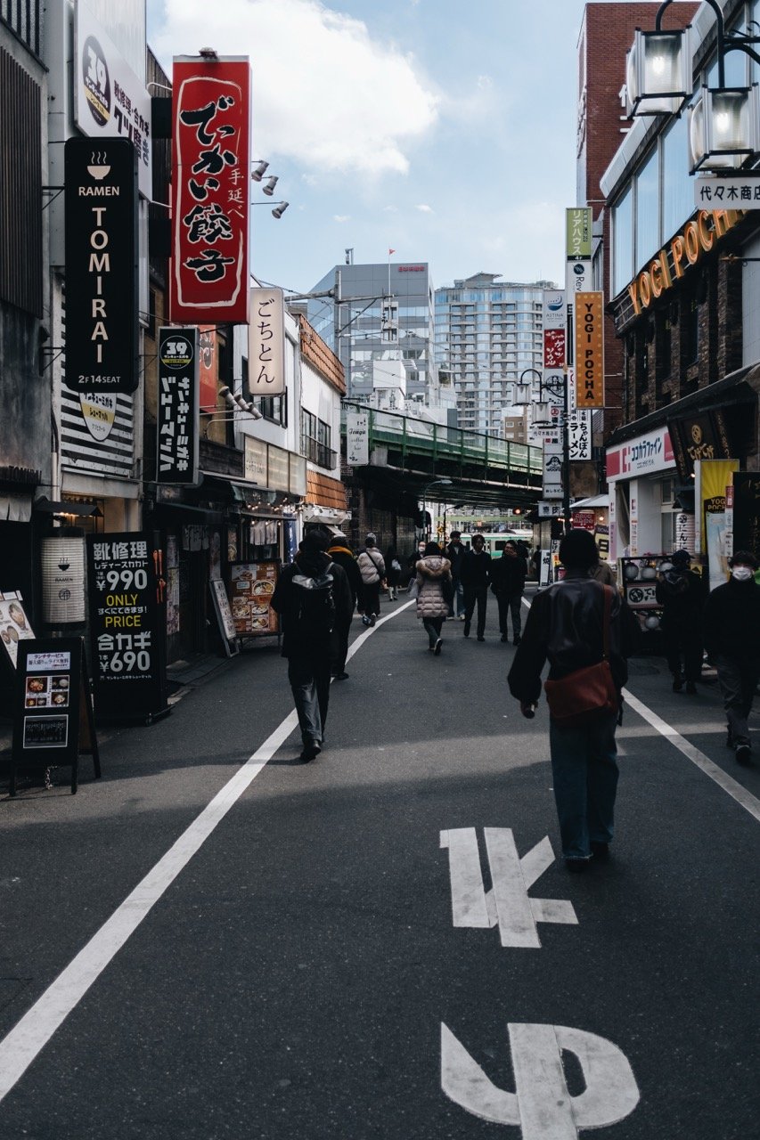
    But there is no shortage of examples from around the world where elevated rail does far more to benefit a community than detract from it. Tokyo is perhaps the obvious place to look. It is decidedly rail-oriented city with the majority of its network above ground and countless examples of active commercial spaces being tucked under and adjacent to elevated rail.

    Here, for example, is a restaurant that I visited on my last trip and that was immediately adjacent to a track:

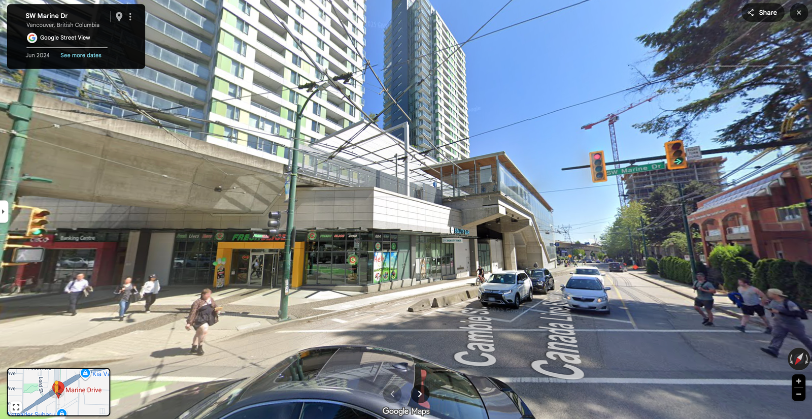
    But you don’t have to travel all the way to Japan to find examples where elevated rail does little to detract from the urban experience. Here’s Marine Drive station in Vancouver, integrated into a newish development:

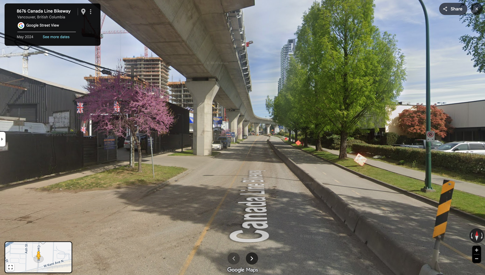
    And here’s what the elevated guideway looks like as it heads toward the station:

    The obvious advantage of elevated rail is that it’s significantly cheaper than underground rail. According to global data collected by the Transit Costs Project at New York University, underground rail tends to be at least 2x the cost — often it’s even more. Are the benefits worth this additional cost, and is it worth building less overall transit with the same capital budget?

    Elevated rail is not without its drawbacks, but good design and urban sensibilities can help to mitigate many of them. As is the case with a lot of urban design, what matters most is how we treat the ground plane underneath the rail. So, to the extent that it remains out there, I think it’s time we get rid of any stigmas associated with elevated rail. More transit is better than less transit.


    Cover photo by Daiji Sasahara on Unsplash

  • The holy grail of street paving

    Last weekend I went by Sidewalk Toronto’s “experimental workspace” at 307 Lake Shore Blvd East. It is open to the public every Sunday from 11am to 5pm if you’d like to drop in.

    This week they had their #BuildingRaincoat on display, which is an adjustable awning system designed to protect public sidewalks, mitigate the impacts of adverse weather, and improve outdoor comfort.

    Also installed were a number of the paving systems that they are currently piloting. They’re working with over 20 different vendors to try and create the “holy grail” of street paving.

    They define that as a system capable of the following four key features: modularity, heating, lighting, and permeability. Here’s an example of what one of them looked like (it was snowing at the time and, yes, Doc Martens):

    With modularity, the goal is to make it possible for a single person to be able to pull up and replace one of the hexagonal slabs. This would dramatically change how we repair and patch our roads. Supposedly, they’re also more resistant to cracks, which means fewer potholes.

    The key benefit of a heated paving system is an obvious one. When needed, their test system automatically heats the slabs to 2-4 degrees celsius in order to melt any snow and/or ice. That’s as warm as you need apparently.

    They have two heating systems running at 307. The first is hydronic (fluid in pipes just below the pavement) and the second is conductive heating (thin conductive film in or under the pavement).

    I’m sure many of you will be questioning the environmental and carbon impact of a heated public realm. And that is certainly a good question. But the status quo in this city involves about 131,000 tons of road salts per year. That’s a problem.

    The lighting feature is pretty neat because there are a variety of different use cases beyond just demarcating space. One example that Sidewalk gives is that it could be used in a bike lane to tell you how fast you need to ride in order to hit all green lights.

    Finally, permeability matters because it minimizes runoff and allows water to be absorbed in situ. The tradeoff is that it makes the slabs structurally weaker. So that is still being worked on.

    I am thrilled to see this sort of urban innovation taking place right here in the city. If you haven’t already, I recommend checking out 307.

  • Blue lights on train platforms

    Sadly, Japan has one of the higher suicide rates in the world. According to the World Health Organization, the rate from 2000 to 2016 was about 18.5 deaths per 100,000. The only country in Asia with a higher rate is South Korea. They are at 26.9 deaths per 100,000 (an alarming figure). For comparison, Canada and the US are at 12.5 and 15.3, respectively, which also seem rather high to me.

    I was intrigued to learn today that one of the ways that Japan has been trying to combat this high figure is by installing blue LED lamps on some of its railway platforms. Blue lights have been proven to have a calming effect (compared to white light). And since jumping in front of a train is unfortunately a common suicide method, blue lights were thought to maybe be a cost effective alternative to platform screen doors.

    The first blue station lights were installed on Tokyo’s Yamanote line in 2009. And according to this 2013 study – which looked at the possible impact across 71 train stations in Japan – the introduction of blue lights actually resulted in an 84% decrease in the number of suicides. Further studies also showed that there were no corresponding increases at other non-blue light stations. 

    It is an interesting example of “nudge theory”, but does it get at the root of the problem?

    Photo by Athena Lam on Unsplash

  • Metrolinx takes first step towards rail + property in Toronto

    image

    I’ve written quite a bit about the advantages of a “rail + property” model when it comes to building public transit. It’s a model that works quite successfully in other parts of the world, such as in Hong Kong.

    However, in North America the notion of land value recapture or of transit authorities acting as real estate developers is still very much in its infancy. We’re myopically focused on rail. 

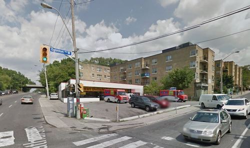
    Which is why I said about 3 months ago that if the stations along the new Eglinton Crosstown LRT line in midtown Toronto became single storey and single purpose buildings, that we will have missed an enormous city building opportunity.

    Since that post I had a number of conversations with the folks over at Metrolinx and I was delighted to learn that there were in fact plans to build additional density on top of the stations. And as of today they’ve gone completely public with that intention.

    Metrolinx, with the help of Avison Young, has just issued a request for proposal (RFP) for 4 sites along Eglinton Avenue in the city. Two of them are at Keele Street, one of them is at Weston Road, and the last one is at Bathurst Street. The 4 sites could generate between $14M – $22M.

    The objective is to find suitable developer partners to help them build on top of their planned LRT stations. And it’s a step in exactly the right direction for Metrolinx and this city.

    Image Source: Google Streetview

  • Why Toronto’s Finch West LRT sucks

    December 10, 2025 · View original


    The new Finch West LRT line opened this past weekend in Toronto. This is a 10.3-kilometer transit line that runs from Humber College to Finch West subway station, and replaces a bus route that was previously one of the busiest in the city.

    It’s also a line that dates back to 2007. I vividly remember reading about this proposal while I was in grad school in the US. Some of you might remember that it was part of Mayor David Miller’s Transit City proposal. Since then, the project got cancelled and revived at least once, which is partially why it took some 18 years to complete.

    Transit openings are typically exciting. A bunch of people lined up on Sunday morning in the cold to be first to ride it. I slept in instead of doing that, but I do fancy myself a transit nerd. Whenever I’m in a new city, I always try to take (or at least test out) their transit system.

    And when the Eglinton LRT finally opens, I do have aspirations to ride from end to end while spinning house and techno music from the rear car. (I have yet to reach out to the TTC to see if they might be interested in accommodating such an activity.)

    But it’s not all excitement. Now that the Finch line is open, the customer reviews are in and the general consensus seems to be that it sucks:

    > A CBC Toronto reporter rode the entire 10.3-kilometre line from east to west Monday morning, finding it took roughly 55 minutes to complete. As a reference point, over 400 runners ran this year’s Toronto Marathon 10-kilometre event in under 55 minutes.

    > CBC Toronto’s eastbound return trip to Finch West Station was about eight minutes shorter, clocking in at roughly 47 minutes. Still, several riders Monday told CBC Radio’s Metro Morning that the previous bus route on Finch Avenue W. was faster and had more stops along the way, making it easier to access.

    So now Torontonians are rightly questioning why our various levels of government spent ~$3.75 billion and took 18 years to build a line that performs worse than what was already there. Hmm. Good question.

    The problems — and I defer to experts like Reece Martin — seem to be a lack of transit signal priority, stop spacing that’s too tight (~500 meters on average), and too many slow zones, among other things. This is highly problematic from a value-for-money standpoint and from an overall transit investment standpoint.

    If we don’t fix this, we haven’t just wasted billions; we’ve probably killed the argument for light rail in this city for a generation. The good news is we know this can work, and that’s because it’s being done successfully all over the world. Let’s go, Toronto. Make it happen.

    Cover photo via Wikipedia

  • Toronto is planning for a post-car future

    August 17, 2025 · View original


    One of the fundamental principles that we espouse on this blog is that land use and transportation planning are integral to one another. This matters if you’re trying to build a big, bad global city because there are limits to what you can accomplish with car-oriented planning. Eventually traffic congestion becomes unbearable and the model starts to breakdown (consider Toronto and Atlanta right now).

    This means that, if you’d like to continue scaling, eventually you’ll need to start getting serious about transit-oriented development and other forms of mobility. Japan is one of the best examples of this. But the key prerequisite for this is urban density. This is the unlock that makes transit practical and convenient for people.

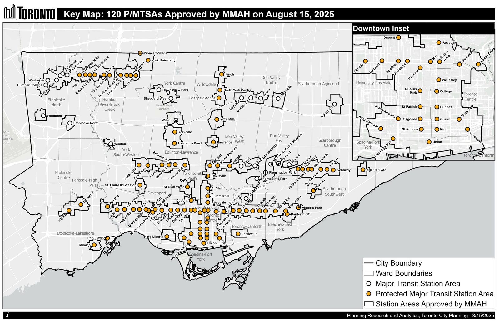
    That’s why this week’s planning announcement is a big one for Toronto. On August 15, the Government of Ontario (through the Ministry of Municipal Affairs and Housing) approved, with some modifications, 120 Major Transit Station Areas and Protected Major Transit Station Areas in the City of Toronto. Here’s a summary of the MMAH’s decision via the City’s website, and below is a map of the transit station areas. (Note that some station areas are missing from this map and are still under review.)

    At a high level, these are areas that fall within an approximately 500-800 meter radius of transit stations, and would therefore be less than a 10-minute walk for most people. It’s land that is best suited to transit-oriented development and that would strengthen any new/existing transit investments. For example, if you have an existing station that is underperforming from a ridership standpoint, the best solution is more density within its immediate catchment area.

    Because of this, Ontario’s Provincial Planning Statement prescribes the following minimum density targets for MTSAs:

    – 200 residents and jobs per hectare for subways – 160 residents and jobs per hectare for light rail or bus rapid transit – 150 residents and jobs per hectare for commuter or regional rail

    And to satisfy these requirements, cities need to demonstrate how they have planned for these minimum targets.

    PMTSAs are a subset of MTSAs and come with some additional features, such as minimum unit counts and/or floor space indexes (floor area ratios). These are also the only transit areas where cities have the option of enabling Inclusionary Zoning, which is something they may do when the market rents in an area are high enough that the subsidies required to build affordable housing can be shifted onto the tenants paying market rents. (My views on inclusionary zoning can be found, here.)

    Over the coming weeks, everyone in the industry is going to be analyzing the implications of this new approval. Overland (which is a legal firm that we work with) just posted on their blog that their review is underway and that they’ll be posting something shortly. But in the meantime, I’d like to say that this is meaningful progress (and one that has been a longtime coming).

    It acknowledges the important link between land use planning and mobility, and it better aligns our policies to support a post-car city. Of course, in many ways, this is an obvious thing to do. I started this post by calling it a fundamental principle of city building. But city planning happens slowly and incrementally. If you’re following along, you’ll see that Toronto is in fact growing up as a big, bad global city.

    Cover photo by Andrii Khrystian on Unsplash

  • Stop with the suburban setbacks

    December 1, 2024 · View original


    I’ll be the first to admit that I have an urban bias. I like walkable narrow streets. I like being able to cycle around. And I like not having to drive when I want to do things. But this can create a city-building blindspot and Paul Kulig, Principal at Perkins&Will Toronto, reminded me of that this week. Here’s a tweet where he compares two streets, both of which have a right-of-way width somewhere around 40m:

    > Tweet: @donnelly_b Both these streets have similar, 40+ metre rights-of-way. One is designed for people, the other prioritizes getting 18-wheelers on and off the 400. https://t.co/w1Ou7ULFGK

    The image on the left is Prenzlauer Allee in Berlin. And the image on the right is Finch Avenue West in Toronto. Despite both having light rail running down the middle, one of these streets is walkable, vibrant, and generally urban, and the other is very suburban. What this reminds us is that a wide street isn’t necessarily an insurmountable challenge. It’s ultimately how we design that street that is the make or break.

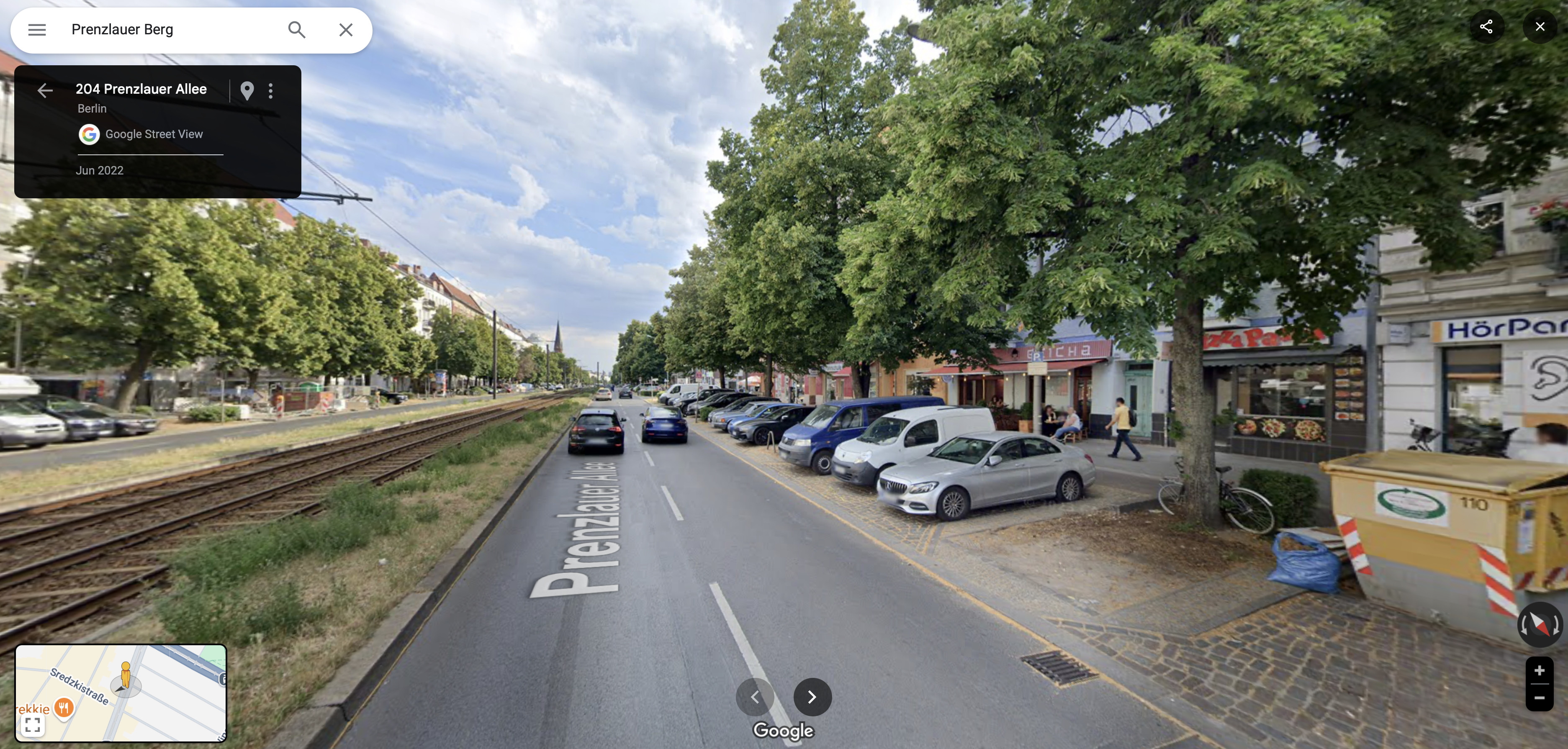
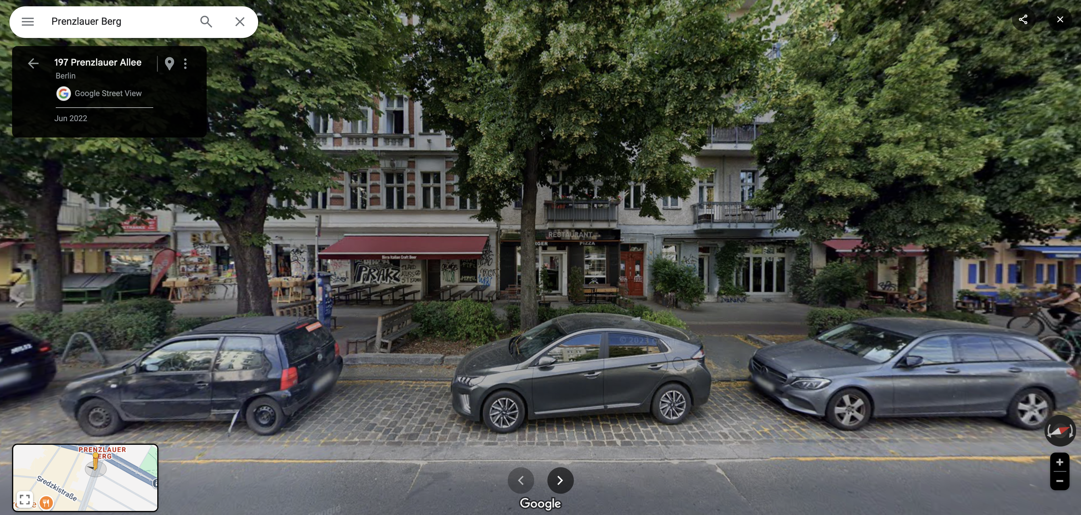
    Here’s another look at Prenzlaurer Allee:

    In addition to transit running down the middle of it, it also has a ton of on-street parking. In many cases, the cars are parked perpendicular to the curb. So it’s not like this street isn’t also accommodating to motorists. The key differentiator is how the buildings are placed. They come right up to the street and are accompanied by a great pedestrian realm (note all the patios below).

    This is one of the things that Toronto needs to be focused on following the investments made in public transit on streets like Finch and Eglinton. We don’t want generous setbacks on these streets. Make them 0m. Towers in a park kill any chance of street life. We can talk all we want about “active frontages” on our arterial roads, but who wants to sit on a patio on a street like Finch? Nobody.

    But as Berlin shows, there’s absolutely no reason why we couldn’t change that. Thanks for the reminder, Paul.

    Cover photo via Google Street View