Daily insights for city builders, delivered every morning at 6 AM ET. I’m Brandon Donnelly — a Toronto-based real estate developer and founder of Globizen. I’ve been writing here since 2013.

Search results for: “light rail”

  • The longest cable car line in the world is in Mexico City

    Mexico City is all kinds of big. It is the largest metropolitan area in North America, the largest Spanish-speaking city, and broadly one of the largest megacities in the world. Because of this, it can be, you know, hard to move around.

    I remember visiting the city for the first time when I was in elementary school, and it standing out to me that everyone had one day of the week when they were simply not allowed to drive their car. It was/is a form of load balancing. Imagine that. (I don’t know if this is still the case, or if it’s even more stringent today.)

    I also remember visiting the city later on, when I was in grad school, and it standing out to me that their metro had women-only cars. This was and continues to be an attempt to try and minimize the amount of sexual harassment that takes place on transit. Again, it can be hard to move around Mexico City.

    The city’s latest solution is one that has found success in other Latin American cities, such as Medellin, and that is: cable cars. Relative to subway or light rail, they’re inexpensive. They’re also good at navigating steep terrain, and their stations can be inserted into dense urban areas. This includes working-class neighborhoods who might otherwise have very limited mobility options.

    For reasons like these, Mexico City has spent the last three years building three new cable car lines, the most recent of which opened just last month. The city now has the longest cable car line in the world. But more importantly, it has a new transit add-on that is moving up to 80,000 people per day.

    This isn’t as much as rail. But that’s okay. The point of these lines is to bring more people closer in so that they can then connect to more services and other mobility options. And to do it quickly. Three new lines in three years is impressive. And from the sounds of it, it has transformed many people’s lives for the better.

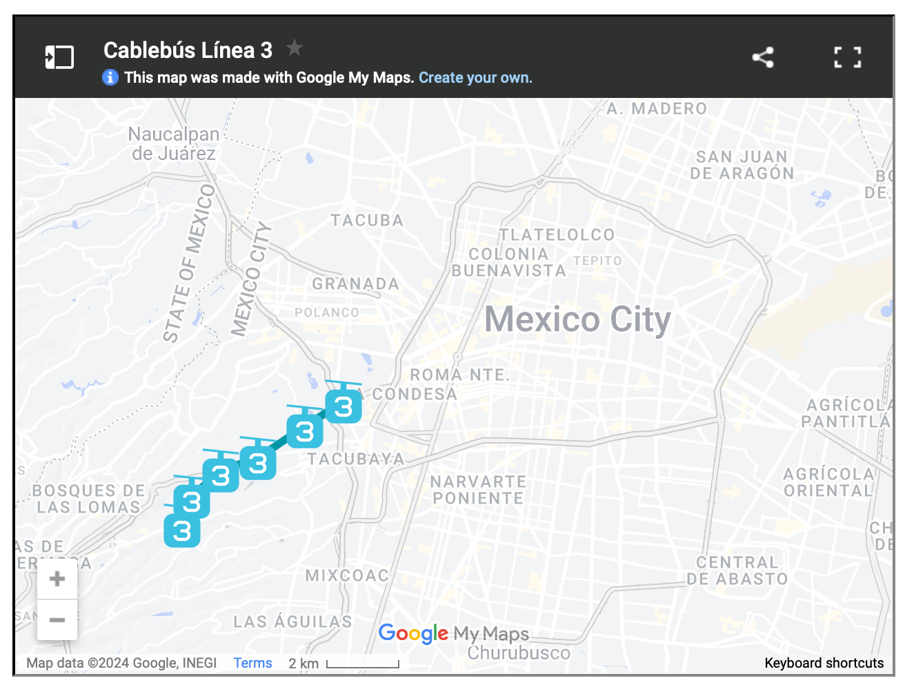
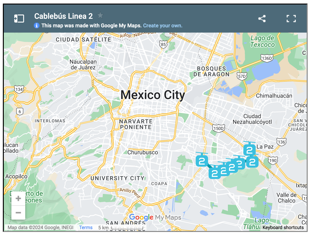
    Here are maps of the 3 lines, zoomed out a bit so that you can see how they fit into the city’s broader urban context:

  • Bordeaux’s tramway network

    I was very impressed by Bordeaux’s tramway network. It felt like no matter where you were in the city, there was a tram gracefully passing you by. Here’s a high-level summary of the system:

    • The network has 4 lines and a total route length of 77.5 km.
    • The first line opened in 2003.
    • The network has 130 stops, which crudely results in an average stop spacing of around 600 m.
    • The system pioneered ground-level power supply for the trains, which means no overhead wires. Supposedly this caused some issues upfront, but now it seems to be working just fine.
    • Most of the network runs on a dedicated right-of-way (en site propre). Meaning, the trains don’t compete with car traffic. Many of the lines are quite beautiful too – see above video.
    • In 2018, the network carried close to 100 million people. This is in a city of ~260k people and a metro area of ~1.4 million people (2020).

    The key differentiators for me are (1) the stop spacing and (2) the fact that most of the system runs on its own dedicated right-of-way. These are two reasons why Toronto’s streetcars perform so poorly. They stop too frequently. And most of the lines have to compete with traffic.

    So why bother? Walking can be faster.

    Bordeaux shows that — if you implement light rail correctly — you can actually move a ton people efficiently. With surface rail, you can also build out a robust network in a relatively short period of time.

    Twenty years isn’t that long in city-building years. It has already been 10 years since Toronto was first promised SmartTrack.

  • Slamming the breaks on anti-motorist measures

    Last week the Prime Minister of the UK, Rishi Sunak, announced a number of initiatives designed to support drivers. The slogan is “slamming the brakes on anti-motorist measures” and you can find more information about it, over here.

    Naturally this is sparking the usual debate about driving vs. all the other forms of mobility. But it also seems to be part of some sort of broader political strategy intended to distance his party from things like environmental sustainability, net zero targets, and 15-minute city design.

    If you’re looking for a way to process the above announcement, this recent FT article by John Burn-Murdoch is an excellent place to start. Firstly, the UK (outside of London) is generally poorly served by public transport. This is an important thing to know. By the below measure — percentage of large cities that have trams, a metro, or urban light rail — it is even worse than the US:

    In fact, one way to think about and measure mobility in the UK is to think in terms of the following geographic categories: there’s US cities, European cities (including London), and then there’s the rest of the UK. In the case of US cities, they have very clearly optimized around road infrastructure. Meaning, the vast majority of people don’t take transit to work, but the area (km2) you can cover by car (in 30 mins) is high.

    Look at Houston and Dallas on the left side of this graph:

    On the other hand, European cities (again, including London) have optimized in the opposite direction. A lot more people walk, cycle, and take transit to work. In the case of cities like London, Paris, Barcelona, Bilbao, Prague, and others, the number is greater than 60%! However, they’re sucky places to drive, as I learned this past summer. The area you can cover by car within 30 mins, is relatively low (bottom right of the above graph).

    The challenge for British cities (excluding London), is that they seem to be right in the middle (burgundy dots above). Poor public transport (low percentage of trips to work). And poor road infrastructure (limited area accessible by car within 30 mins). So it is perhaps no surprise that Sunak is honing in on this issue. London is not representative of Britain. And based on the above data, the majority of people living in British cities are almost certainly mobility frustrated.

    Of course, to correct this issue you have two options. You can move toward the left (in the above chart) and optimize for road infrastructure. Or you can move to the right and optimize for public transport and other forms of mobility. Based on last week’s announcement, Sunak has chosen the left.

    Charts: FT

  • Phase one of Montreal’s REM is now open

    The first phase of Montreal’s new Réseau express métropolitain (or REM) just opened it up. It is a 17 km light-rail line that includes five stations running from Brossard in the south (A1 above) to Gare Centrale in downtown Montreal. Eventually this network — which is distinct from but connected to the city’s existing metro network operated by STM — will span 67 kilometers and have a total of 26 stations. To put this into perspective, Montreal’s current metro totals 69.2 kms. So this is a near doubling.

    As with most big city building projects, Montreal’s REM is being and will continue to be criticized. Back in 2016, the project had an estimated total project cost of $5.9 billion. By 2021, this number had increased to $6.9 billion. Today, who knows what the number will be. But it will be more. The reality is that everything went up, by a lot, over the last five years. During the pandemic, we were seeing 30-40% cost increases on some of our construction line items.

    What’s perhaps most noteworthy about this project is its delivery model. It is being delivered through a partnership with the the Caisse de dépôt et placement du Québec (CDPQ):

    Under the pact, the Caisse’s infrastructure arm is assuming $3.5-billion of the project’s $6.9-billion construction cost while Quebec is committing $1.28-billion and the Canada Infrastructure Bank is providing a $1.28-billion loan. The balance consists of a $295-million payment from Hydro-Québec for the line’s electrification, while the Autorité régionale de transport métropolitain, the transit authority for the Montreal region, is pledging $512-million.

    Provincial and local governments will provide continuing operating subsidies for the REM to make sure the Caisse earns its required return on the project, currently pegged at 8 to 9 per cent. The pension fund manager will get 72 cents for each passenger-kilometre travelled on the light rail system. Without such a subsidy, fares would climb to a level few passengers could afford.

    It’ll be interesting to see how this approach stands the test of time. As I understand it, CDPQ wants to continue building and operating transit in other cities around the world. I don’t know any of the specifics other than what I have read online. But from the outside, things seem to be working. The first phase of the REM broke ground in April 2018, and the opening ceremony was held this month (July 2023). That’s basically warp speed in transit timelines.

    Map: Montreal REM

  • Warren Buffet doesn’t like crypto and streetcars

    I have a great deal of respect for Warren Buffet. Much of what I know (or think I know) about investing has come from listening to and watching him and his partner Charlie Munger. Surely they have got to be the most successful investors living today.

    But there are some things that I don’t always agree with them on. The first and most obvious one is crypto. Warren thinks it is speculative rat poison and I think it is the future of the internet. I understand where he is coming from in that it does not produce cash in the same way as say a farm or an apartment building. But that doesn’t mean it won’t have value.

    The second one, as I have learned today, is maybe streetcars. As a rule, Warren doesn’t typically engage in local politics. But he recently decided to break that rule through a letter he wrote to the editor of the Omaha World-Herald, lobbying against a new $306 million project that I believe is going ahead regardless.

    Here’s an excerpt from the letter:

    “Residents can be far better served by extended or more intensive service by the bus system,” Buffett wrote. “As population, commerce and desired destinations shift, a bus system can be re-engineered. Streetcars keep mindlessly rolling on, fuelled by large public subsidies. Mistakes are literally cast in cement.”

    I should, however, be clear that (1) I know nothing about Omaha and this streetcar project, and (2) “streetcars” can be nuanced. There are streetcars that compete with car traffic and have short station spacing, and there is light rail transit on its own dedicated tracks and with farther station spacing. One size does not fit all.

    Here in Toronto, we have lots of the former and they generally move you around at the slowest possible speeds. Sometimes it is faster to just walk. But we are also getting a new light rail line next year and that should move much faster. I can also tell you that when I worked in Dublin many years ago, I took their Luas to the office every day and loved it.

    Again, I don’t know the specifics of Omaha’s streetcar project. Maybe Warren is right or maybe he is wrong. And that’s why I was careful to say “maybe” above. But I do know that in the right urban contexts and when done well, I am a fan of light rail transit.

  • Below grade at Yonge & Eglinton

    I often hear people lamenting about all of the construction that is taking place right now at Yonge & Eglinton in midtown Toronto. But that’s kind of what happens when you build a new subway line (okay, a partially buried light rail transit line). Above is a recent drone video that Metrolinx released showing the progress at Eglinton Station (I think I would have gone with a little Booka Shade for the soundtrack instead). I bet that most of you will be surprised to see how much is happening beneath street level. If you can’t see the above video, click here.

  • A completely car-free neighborhood in Arizona

    The New York Times recently published this interesting piece about Culdesac and the completely car-free community that they are building just east of Phoenix in Tempe, Arizona (a place that is not generally known for its walkability). Culdesac calls itself the first “post-car real estate developer in the United States.” And so their Culdesac Tempe project has been designed to house 1,000 residents and exactly 0 cars.

    When the first phase is completed next year, residents will be restricted from having a car within the community and they’ll also be restricted from parking on any nearby streets. (This second stipulation was done to assuage concerns that a zero parking community would create a spillover effect in the surrounding area.) Instead, residents of Culdesac Tempe will rely on their local amenities, as well as on transit (it’s on a light rail line), biking, ride-sharing, and other forms of urban mobility.

    While this may seem kind of crazy for sprawling Arizona, the company’s thesis is both clear and clever. The future of American cities needs to be the kind of walkable urbanism that you find in places like the northeast. But at the same time, the fastest growing cities in the United States are generally in the Sun Belt. What they are doing is building walkable urbanism in the places where people clearly want to live.

  • Are car tunnels the solution to traffic congestion?

    Elon Musk recently posted this Twitter survey asking if we, the people, would like “super safe, Earthquake-proof tunnels under [our] cities to solve traffic.” It was leading in that the “no” response was, “No, I like traffic.” And it was initially vague in that it wasn’t clear how these tunnels would be used. Though, most of us could probably guess. Elon later added in the thread that these road tunnels would be for zero emission vehicles only and they would be limited to EVs (from all auto companies, not just Tesla). Finally, Elon stated that these tunnels are not intended to replace other solutions, such as light rail, rather to supplement them.

    At the time of writing this post, nearly 1.5 million people had responded to the survey and about 67% of them said “definitely” to Earthquake-proof tunnels. Elon’s reaction: “Stop whining, subway Stalinists, the people have spoken.” Notwithstanding the majority, this is a divisive topic and the reactions are mixed. City planner Brent Toderian responded by saying that this “solution” would merely result in more cars, more driving, and more emissions. Steve Jurvetson, on the other hand, argued that this would be the cheapest way to add lanes and prepare for the inevitable EV-only future. (Steve sits on Tesla’s board and recently launched a venture fund that, among other things, invests in sustainable mobility.)

    The crux of this divide is a view about how cities should work. And it often becomes like dogma. Is it optimal for us to all be driving around in individual vehicles — EV or not? Will autonomous vehicles actually help solve the traffic problem? Or is building on the backbone of mass transit the only way to properly design a big and efficient city? Whether it’s lip service or not, Elon seems to acknowledge that both cars and transit are important, and that both can work together to supplement each other.

    What is clear to me is that cities, at the scale of say Tokyo, wouldn’t function nearly as efficiently if it weren’t for their extensive fixed rail networks. At the same time, there are many cities (or portions of cities) that do not have the prerequisite population and employment densities to support this same level of transit investment. And that has created a strong pull away from transit (and active transport such as cycling) toward private vehicles. Sprawling cities signal to people that they should probably be driving. This is one of the reasons why land use should never be separated from mobility discussions.

    How autonomous vehicles change all of this remains to be seen. Though I do think it will make cars less private and more public transit-like. Studies show that most of us are pretty good at coming up with incremental improvements to the things we already know and understand. i.e. This is how I would make this car better. But we’re far worse at coming up with and predicting tectonic shifts in the landscape. And autonomy is probably one of those shifts. But as long as our built form remains heterogeneous, I am inclined to believe that a mixture of mobility solutions will be needed. Maybe that means car tunnels. Or maybe it doesn’t.

    Photo by Ricardo Gomez Angel on Unsplash

  • The capital of the future: Shanghai

    Joe Berridge’s recent opinion piece in the Globe and Mail makes the case for why Shanghai is destined to become “the capital of future.” Brash city building, massive scale, and entrepreneurial hustle are among some of the reasons why he believes the city is on a path to global supremacy. And similar to other great capitals, it has benefited from a strategic geographic position on an important waterway — in this case the Yangtze River.

    By way of comparison, Toronto is said to be the fastest growing urban region in both North America and Europe right now. We add somewhere around 125,000 people each year. Shanghai, on the other hand, is adding between 700,000 and 800,000 people each year — much of it from internal migration. The city currently has a population of around 24 million people and it is expected to grow to somewhere between 35 and 45 million people by 2050. (Figures from the Globe.)

    Notwithstanding all of our successes as a global city region, as I was reading Berridge’s piece I couldn’t help but come back to this comparison. Shanghai opened its first subway line in 1993. Today it has one of the most extensive networks in the world; whereas, it would probably take Toronto this long to figure out if that first line should be light rail or a below-grade subway. And we haven’t even gotten to the number of stops yet.

    But that’s one of the differences between top-down and bottom-up city building: speed.

    Photo by Denys Nevozhai on Unsplash

  • How’s your PTAL these days?

    image

    As I was going through the new London Plan yesterday I noticed a number of references to PTAL. I didn’t know what this was, so I obviously had to look it up.

    It stands for Public Transit Accessibility Level. It’s a methodology that was developed in London in the 90′s. And it’s a measure of access to public transit, or of the density of the public transport network at any given location.

    There are 6 levels, though two of the levels are further subdivided into 2 sub-levels for greater precision:

    • 1a and 1b
    • 2
    • 3
    • 4
    • 5
    • 6a and 6b

    1 is bad. 6 is good. 

    What’s captured in this measure are the walking times from a particular location to the nearest transit access points; the reliability of the available services; the number of services available; and the average wait times.

    Historically, this measure has helped to determine how much density could be built on a particular site, how much parking should be provided, and so on. 

    For example, in the new London Plan, PTAL 5 and 6, as well as Inner London PTAL 4, are expected to see development with no residential parking. Once you move to PTAL 3, the parking maximum moves up to 0.25 spaces per unit. 

    In the draft London Plan you’re also supposed to use the highest existing or planned PTAL. So if transit improvements are planned for the area, you factor those into the calculation.

    Seems quite rationale (though it’s probably not a perfect measure of access and connectivity).

    If you’d like to determine the PTAL for a particular address in Greater London, you can do that here. Unfortunately, I don’t have a calculator for you if you happen to live outside of London. But there is one simple check you can do.

    The PTAL methodology assumes an average walking speed of 4.8 kph. The maximum allowable walk time for buses is 8 minutes and the maximum walk time for subway and light rail is 12 minutes. These numbers translate into distances of 640m and 960m, respectively.

    How far do you have to walk to access good transit?

    Photo by Bruno Martins on Unsplash