Daily insights for city builders, delivered every morning at 6 AM ET. I’m Brandon Donnelly — a Toronto-based real estate developer and founder of Globizen. I’ve been writing here since 2013.

Category: Urbanism

  • Louis Vuitton’s Big Duck

    When I first saw this picture of Louis Vuitton’s flagship store in Manhattan I thought it was AI. That is where we are right now. When something looks wild, I just automatically assume it’s fake. But alas, it’s not fake. Louis Vuitton is renovating their flagship store at the corner of 57th Street and 5th Avenue and so, naturally, they decided to completely cover it with luggage facade wraps.

    These wraps make the entire building look like six grey trunks stacked on top of each other and are a nod to a 19th century luggage design from the company. They even used real metal details throughout. Apparently the heaviest luggage handle weighs something like 5,000 pounds.

    This is wild and remarkable in so many ways. The scale of it is remarkable. This is a 15 storey building concealed entirely by luggage trunks. It also speaks to the scale and dominance of New York as a city. Not every city can absorb a pile of giant luggage trunks and not bat an eye. But in New York, it’s just another noteworthy thing within its relentless urban grid.

    I also can’t help but think of the work of architects Robert Venturi and Denise Scott Brown. In 1972, they published a book called Learning from Las Vegas. And in it, they defined two types of contrasting buildings: decorated sheds and ducks. Decorated sheds are, as the name suggests, nondescript buildings. Think big box stores. These buildings get their specificity from signage and other ornament because, without this, they’d just be nondescript sheds.

    Duck buildings are, on the other hand, buildings that take on a symbolic form. In other words, their shape and construction tell you what they’re all about. The term duck comes from an actual building that looks like a duck, namely The Big Duck on Long Island. This is a building that was built in the 1930s to help promote the owner’s duck farming business and is now on the US National Register of Historic Places.

    The Big Duck is and was an actual building, whereas Louis Vuitton’s trunks are just temporary construction wrap. So they’re not exactly the same thing. Still, the similarities are there. Both were erected to promote their respectiveness businesses. And both tell you, through their form, what’s meant to happen inside. So in this sense, Louis Vuitton has just created its own Big Duck.

    Photo by Brad Dickson via Dezeen

  • What happens when Uber doesn’t have to pay its drivers?

    This is an interesting video by Phil Andrews of Maxinomics talking about the economics of Uber and what it could stand to gain from autonomous vehicles.

    As part of this, he touches on the exclusive partnership that was announced between Uber and Waymo back in September. That was a big deal.

    I find this topic fascinating because it’s hard to imagine it not reshaping the landscape of our cities. And it continues to get more real by the day.

  • Paris may have the busiest bike route in the world

    In my opinion, we need far better urban data if we’re actually going to make evidence-based decisions. Thankfully, there are lots of great companies that are focused on this space. One of them is Eco-Counter, which makes devices to count pedestrians and cyclists, among other things. This is an important job, because as Peter Drucker used to say, “you can’t manage what you don’t measure.”

    Let’s look at their bike counters. According to their global map, they have 464 of them installed around the world. Montreal has 58 of them, which we’ve spoken about before, and is an impressive install base. And Toronto looks to have only one, which is located on Bloor Street on the north side of High Park.

    The busiest route/counter in Montreal is at St-Denis Street and Rue des Carriéres. So far this year — up to November 17, 2024 — this counter has seen an average of just under 5,000 trips per day and a year-to-date total of 1,600,468 trips. Both of these metrics are notably up compared to 2023 when I last looked at the data.

    The busiest route in Eco-Counter’s entire network is on Boulevard de Sébastopol in Paris (an important main roadway, not a side street). It has seen an average of 13,667 trips per day and a year-to-date total of 4,386,996 trips. Not surprisingly, the Paris counter exhibits less seasonality. People still cycle in the winter in Montreal, but it’s less than in the warmer months.

    Finally, our lone Toronto counter adjacent to High Park has seen an average of 1,186 trips per day and a year-to-date total of 380,813 trips. Not quite Paris or Montreal (the latter of which has a colder climate), but I would argue that this really isn’t an indicative location for Toronto given how underdeveloped the area is. Plus, you need to see each route as part of a network.

    If you look at Montreal’s top 5 bike counters, all of them have a year-to-date total that exceeds 1 million trips. This is important information if you’re trying to make mobility decisions and these are significant figures. Imagine if these millions of people got off their bikes and instead decided to take transit or drive a car. That would change things.

    Photo by Celine Ylmz on Unsplash

  • Manhattan’s congestion charge is back, maybe

    I first wrote about Manhattan’s proposed congestion charge back in 2018. Naturally, some people supported it and some people opposed it. Four years later, it was reported that the charge was still being considered for the area of the island south of 60th Street, and that it could generate an additional $1 billion in revenue for the city’s transportation authority. But then in June of this year, right before the charge was set to come into effect on June 30, 2024, New York Governor Kathy Hochul said “nah, let’s pause this indefinitely.” And at that point, it felt mostly dead.

    Nope: A revised tolling plan has just been announced — the charge has been reduced from $15 to $9 — and Hochul is now trying to jam it through before Trump takes office in January. Trump opposes the charge and has branded it the “most regressive tax known to womankind”, so there’s a real deadline here. This could get interesting. Do you think it will actually happen, some 6 years later? (In reality, the timeline is far longer. Congestion pricing also looked promising during the Bloomberg era, but then similarly died. And I’m sure there were even earlier proposals.)

  • Environmental Defence publishes new mid-rise building manual

    Ontario’s goal is to build 1.5 million new homes by 2031. It is widely understood that we need a lot more housing. But it’s a bit of a curious thing, because we do actually have homes available right now. There are developers with standing condominium inventory; landlords with vacant apartments; and many other options. So what is it that we need exactly? A more precise description would be that we need a diverse mixture of more attainable housing.

    For this to happen, we’re going to need to make some structural changes to the way we deliver new homes. The above image is taken from a recent report by Environmental Defence and Robert Eisenberg (in collaboration with LGA Architectural Partners and SvN Architects + Planners). The report is called the Mid-Rise Manual and it’s a comprehensive look at we can and should be doing to unlock more of this housing type.

    What I love about this image (and the report) is that it speaks to a very different kind of city than the one we have grown accustomed to in North America. Instead of towers in a sea of low-rise houses, it shows a diversity of building types — in a way where you could also imagine a diversity of individual home types. This is unequivocally where cities like Toronto and others are headed. It’s just a question of how soon we follow the manual.

    Click here to download a copy of the report. (There’s also a summary report of key takeaways if you’re looking for something quick to read.)

  • Audio is the poor person’s augmented reality

    I have long been interested in the work of entrepreneur Dennis Crowley. He is perhaps best known as the co-founder of Foursquare, which popularized location “check-ins.” But he’s created a bunch of other stuff too. The common theme is that his products exist at the intersection of tech and cities (the physical world), which is probably why I’ve been so interested over the years.

    Check-ins, for example, allowed you to say to all your friends, “hey everyone, I’m at this bar.” It was a way of checking if anyone you knew was there too, or close by, and also a way of inviting your friends to come join you if they were so inclined.

    This was extremely popular for a period of time, but then kind of fizzled out, and Foursquare was forced to pivot and try a bunch of other things. And in the end, this “problem” of augmenting the physical world with our social graph (and other information) never really got solved. I mean, this is broadly the promise of augmented reality.

    Thankfully, Dennis has a new company (Hopscotch Labs) and a new tech/city product called Beebop (which is currently in private beta). Here’s how it works (excerpt from this Crazy Stupid Tech interview):

    It’s an iPhone app. There’s not much to do in the app, there aren’t a lot of buttons to press. Once it’s installed and you set the permissions, every time you put on your headphones — your AirPods or any other headphones, it doesn’t matter—it chimes and says, “Beebop’s been activated.” (Beebop is the first project from the company, Hopscotch Labs.)

    Then as you walk around the city, it will tell you things about certain places. Eventually, if I walk by a place where my friend was, it tells me that Alex was here two days ago. If I walk by a place and someone’s inside, it tells me that Max is inside that place. A lot of it is still under development. Eventually, people leave a comment at a place. Imagine Twitter. It is as if you leave a tweet and you stick it in the ground. When you walk over it, you hear it.

    So like before, it’s about experiencing cities:

    It’s been a long time since I built something. What’s different now? AI is what’s different. You know what’s different? Everyone’s on their phones all the time. Back in my day, we made stuff for the streets. You would use your phone, you’d put it away, and stuff would happen. Where are the people making that stuff anymore? All we make is stuff that makes you look at the screen. Let’s make stuff that gets you out in the world, where you’re not glued to the devices. You’re out there doing stuff. Big companies out there aren’t going to make stuff like this.

    The key idea here is that augmented reality doesn’t have to just be visual. Visual also requires somebody to figure out a cool set of glasses that people will actually wear out in public. Who knows when this happens, though I do think it will eventually.

    So what Dennis is doing is making something that works today — with audio. This has been called the poor person’s augmented reality, but I think that’s selling it short. This is really clever. And once again, it’s fundamentally connected to how people live in and interact with our cities.

  • Paris introduces new limited traffic zone

    As counterintuitive as it may sound, one way you could try and improve traffic congestion is to discourage people from riding their bikes and instead encourage them to drive more. That’s what’s happening in Toronto right now. Another way is to dramatically restrict car usage. And starting this Monday, that’s what Paris will be doing with its new limited traffic zone (zone à trafic limité) in the center of the city:

    This new ZTL is approximately 5 square kilometers. About 100,000 people live within its boundaries, and it is estimated that somewhere between 350,000 to 500,000 vehicles enter it each day. But according to the city, it is estimated that only around 30% of these trips are absolutely necessary (because of a lack of alternatives, for example). The purpose of the ZTL is to reduce the unnecessary ones.

    The way it will work is that drivers will no longer be allowed to drive through this zone. You’ll only be able to enter if you plan on stopping for a legitimate reason. It’s not yet clear what this exact list of approved reasons will be, but the general idea is that if you want to drive in for dinner or to attend a meeting, that’s fine. What you can’t do, though, is just drive around in a souped-up Honda Civic blasting Taylor Swift.

    The next 6 months are planned to be a period of education. Drivers exiting the zone are just going to be told that there’s this new ZTL and that they better have stopped somewhere. But eventually there will be a 135 euro fine and eventually drivers will be expected to furnish some sort of supporting evidence for their stop, such as a restaurant receipt. There’s also talk of adding automatic cameras.

    Of course, this creates a lot of gray areas. What about if you’re just going over to a friend’s place for dinner? Will they then need to write you a note saying that you went over for some homemade bouillabaisse? Yeah, I don’t know the answer to this. But you have to admit that this is a bold city-building move, and a far more effective way of improving traffic flows.

    Unlike removing bike lanes, this plan will actually work.

  • Canada announces high-speed rail between Quebec City and Toronto — finally!

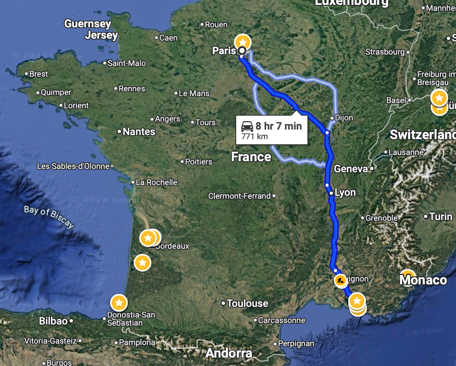
    The train from Paris to Marseille takes just over 3 hours:

    To drive this same distance, it would take just over 8 hours:

    So unless you had a very specific reason, I don’t know why you’d ever want to drive this route. I certainly hate long drives and would avoid this at all costs.

    On a related note, the Canadian government announced this week that it will actually be moving forward with a high-speed train linking Québec City to Toronto, stopping in Peterborough, Ottawa, Montréal, Trois-Rivières, and Laval. And unlike previous announcements, it will actually go pretty fast — upwards of 300 km/h, which is comparable to what the TGV does on the above route.

    There are three consortia currently competing for this contract, but apparently the federal government has already chosen a winning bidder. An announcement is expected next month. At the same time, the project office owns all of the bids, and so there’s a chance that elements from each of them could be used in the final project.

    According to official messaging, the design alone is expected to take some 4 to 5 years, which is an eternity and way too long. But at least we seem to be moving forward. This rail link is a no brainer. It will compress the geography of an importantly bilingual corridor with nearly 20 million people — about half the population of Canada! It’s our megalopolis.

    Now we just need to move forward with urgency and with an unwavering commitment to creating the best high-speed rail service in the world. Let’s not accept mediocrity. And let’s not cancel it once we’ve already sunk millions into it. That would be a terrible outcome for such an obviously important nation-building project.

    LFG.

  • Mass transit with on-demand service

    Here’s what we know:

    In the mid-20th century, the US made a pivotal choice that shaped its cities, economy and lifestyle. It chose highways and cars over public transit. At the time, this seemed like the future: the freedom of the open road, the allure of suburban living, and the booming post-second world war economy all converged to push America towards a car-centric culture.

    The Federal-Aid Highway Act of 1956 cemented this vision, unleashing a highway system that encouraged suburban sprawl, fuelled the automotive industry and sidelined public transit. Rail systems were seen as relics of a slow, industrial-era technology ill-suited to America’s postwar aspirations. The car was king. 

    But this congested system is breaking. In 1950 about 30 per cent of the world’s population lived in cities. By 2030 this is expected to reach 60 per cent. Infrastructure cannot keep up with this growth. An increase in cars further reduces street capacity.

    What we don’t have a clear consensus on, though, is the path forward. Is it more highways? More public transit? More bike lanes? Or will autonomous vehicles finally arrive and bail us out? The answer will depend on who you ask.

    In this recent opinion piece, venture capitalist Vinod Khosla makes the case for something else: personal rapid transit systems (or PRT). Conveniently, he also happens to be an investor in one — a company called Glydways.

    The promise is an on-demand mass transit system that offers the convenience of a personal car, but with the capacities and price points of public transit. And it is based on small autonomous vehicles riding in their own dedicated lanes.

    Each lane only needs to be 1.5 meters wide, which is less than the 2.3 meters that the Dutch see as the ideal width of a one-way bike lane. And with this, the company claims that it can reach capacities of up to 10,800 people per hour.

    To further put this into perspective, the standard width of a two-way parking drive aisle here in Toronto is 6 meters. So this would mean that each drive aisle could, in theory, have 4 lanes dedicated to these “Glydcars.” That’s how narrow they are.

    Here’s a video of them in operation:

    This, of course, isn’t an entirely new idea. You might remember that Masdar City in Abu Dhabi claims to have opened the world’s first PRT system in 2010 — a 1.4 km line with only two stations. That said, Glydways has already been awarded three projects in the US. So for fun, I think I’ll keep an eye on them.

  • We need far better urban data

    The divisive debate over bikes lanes in Toronto continues to remind me that we need far better urban data. People and politicians keep touting “evidence-based decisions,” but what exactly is that evidence? The high-level figure being thrown around by the anti-cycling side is that only something like 1% of residents use bike lanes. So obviously it only makes sense to focus on the 99% and not give up any space to this small minority group.

    But this is highly aggregated data. It also doesn’t speak to any of the externalities associated with introducing new bike infrastructure. Looking at 2021 Census data, the number of cyclists was actually around 5% for the old City of Toronto and in some areas it was between 15-20%. However, it’s absolutely critical to note that this is only the people who selected cycling as their “primary mode of commuting” when submitting their responses to the last census.

    Meaning, it excludes people who maybe only cycle 1-2 days a week, or who ride for leisure and/or for exercise, or who ride to their French class in the evenings (like me). I would also assume that these numbers have generally grown since 2021 given the overall investments that have been made in biking infrastructure. So overall, this is weak data. It’s a few years old. And it excludes many types of users. We need to get more granular.

    Like, it’s great to see local business owners speaking out about the benefits that they have seen as a result of the Bloor bike lanes, but in the end, this is also anecdotal. We need real-time data, precise modal splits, the throughput of every major street, and much more. Then maybe we’ll be able to better optimize around the fact that we are a city divided by built form and by politics. That’s the thing about evidence-based decisions, they tend to get stronger with accurate evidence.