Daily insights for city builders, delivered every morning at 6 AM ET. I’m Brandon Donnelly — a Toronto-based real estate developer and founder of Globizen. I’ve been writing here since 2013.

Category: Urbanism

  • How efficient core design unlocks small-footprint infill housing

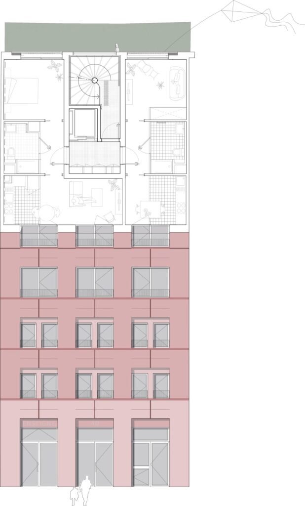
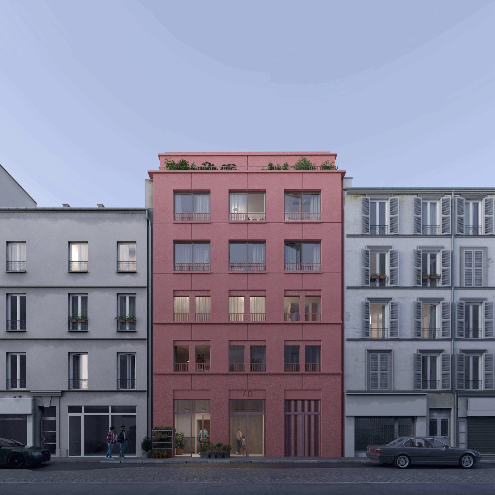
    In today’s edition of How Does Europe Build Such Nice Social Housing?, let’s look at this 8-home project in Pantin (outside of Paris) by Atelier Fuso. (Credit to Philip Oldfield for the tweet that alerted me to the project.)

    First, some stats. The project is 6 storeys (R+5 in European nomenclature), so it’s exactly the kind of housing scale that is contemplated on an as-of-right basis along Toronto’s Major Streets. It has 394 m2 of residential area and 34 m2 of ground-floor commercial. So, about 4,607 square feet of total area. Interestingly enough, this is less than the total area of most infill multiplex projects in Toronto. That tells us the site is compact.

    Second, I’d like to draw your attention to Atelier Fuso’s drawings:
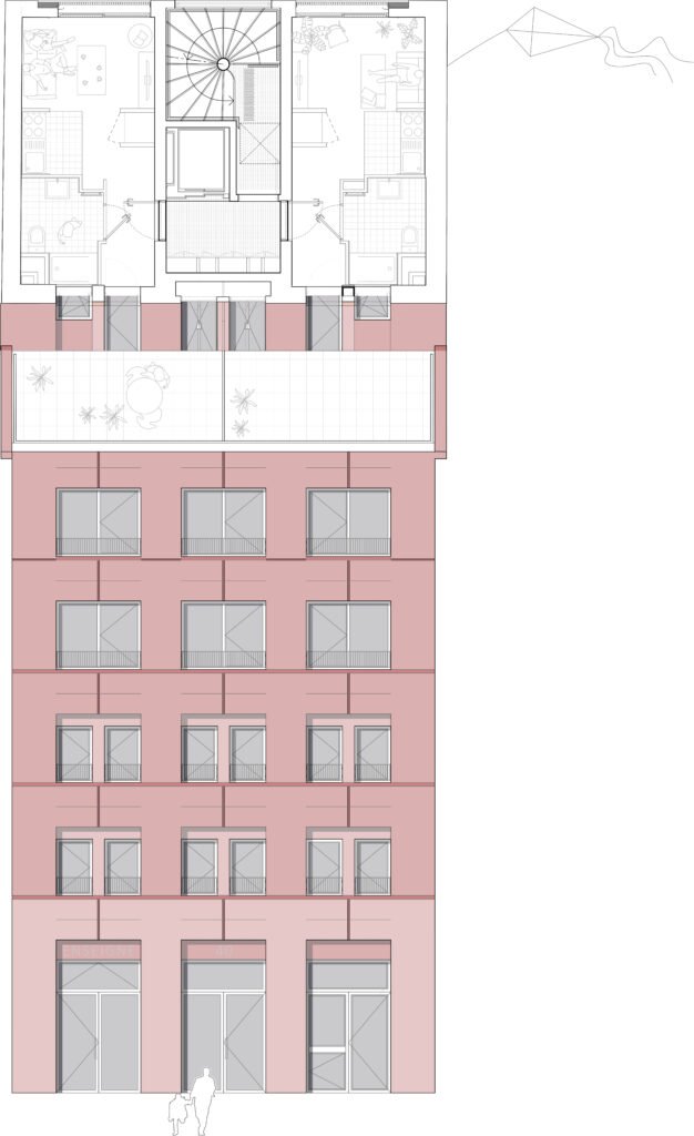
    They combined all of the project’s elevations and plans into single drawings, which is a neat way of showing you the relationship.

    Lastly, let’s look at the project’s costs. The architect’s website shows €1.6M. Whenever I see a cost figure like this, I always assume it’s just the hard costs, and it excludes softs. Whatever the case, €1.6 million to CAD = C$2,544,160. Divided by 4,607 square feet = $552 psf. That feels high for just the hard costs. Are the soft costs less or more than here? I don’t know.

    But once again we are reminded that part of the reason Europe is able to build such nice mid-rise buildings is that they’re able to build on extremely compact sites. And the reason they’re able to build vertically on such compact sites is because they’re able to design building cores that look like the one shown in the above drawings.

    Urban housing like this is comprised of leasable and non-leasable areas. The former generates revenue, and the latter does not. The more developers are able to optimize and reduce the non-leasable areas, such as the core, the more they can build small. That’s a positive thing for cities.


    Image and plans from Atelier Fuso
  • The empty icon

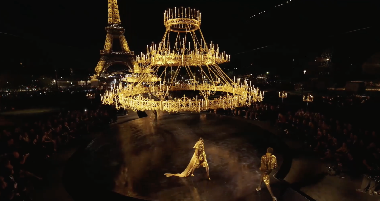
    This week at Paris Fashion Week, Saint Laurent’s creative director Anthony Vaccarello presented an open-air show in front of the Eiffel Tower that is widely rumoured to be his last show at the fashion house. (Too bad.) The set was opulent cinema. Everything was gilded — in an elegant way, not the gaudy Trump way — including the clothes themselves.

    The overall set was intended to pay homage to the historic ballroom of the Hôtel InterContinental, where Yves Saint Laurent himself used to famously present his collections. And suspended above the runway was an enormous gold chandelier that effectively created an “urban ceiling” for the space. Here’s the full show if this at all interests you.

    But this is not a post about fashion.

    One of the things that stood out to me was the obvious relationship between the glittering Eiffel Tower and the enormous gold chandelier. It’s a good example of how you don’t necessarily need walls to frame an urban space. The hanging chandelier was all that was needed to turn a public plaza into a private salon.

    At the same time, I was struck by how sexy and glamorous Paris always manages to make what is effectively a piece of raw industrial architecture. The Eiffel Tower was immediately popular with the general public at the 1889 Exposition Universelle because of its awe-inspiring stature, but elites derided it for its lack of Parisian taste. So how then did it become so synonymous with French high culture?

    One theory is that it’s because the tower is generally useless.

    In 1964, French theorist Roland Barthes wrote an essay where he argued that the Eiffel Tower became the ultimate global symbol precisely because it means basically nothing in itself, which is why it can be so easily imbued with other symbolic meaning. The Louvre is art. The Arc de Triomphe commemorates a military victory. And Notre-Dame is religion.

    The Eiffel Tower, by contrast, is empty. It’s more or less a hollow skeleton of iron. Barthes called this an “empty signifier.” In other words, it’s a blank canvas — one that has come to symbolize everything from 19th-century industrial progress to 21st-century luxury fashion. Its greatest strength may be its uselessness.

    It can be hard to predict when something might resonate in the way that the Eiffel Tower has. The so-called cultural elites certainly didn’t get it at the time. But cities desperately need these urban symbols, and what they come to mean ultimately depends on the urban context and positioning we choose to create. It’s malleable.

    Take, for instance, the CN Tower in Toronto. There is nothing inherent to its concrete form that prevents it from symbolizing high design or civic sophistication in the way the Eiffel Tower does. The difference is in the curation: at its base, we put an aquarium; Paris brings out gilded Saint Laurent.

    Saint Laurent’s show this week was equal parts marketing for the fashion house and for the city.

  • Density by necessity

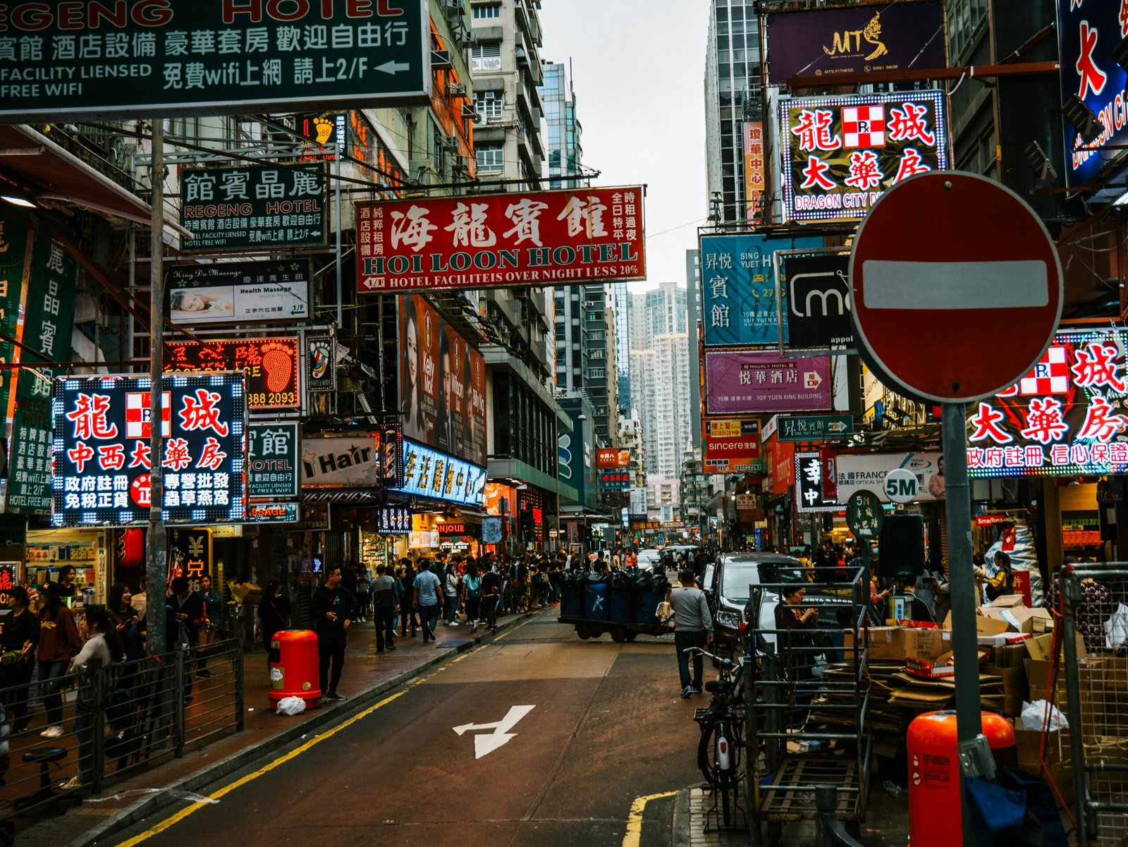
    A blog reader sent me this article by Adam Clermont arguing that “Hong Kong was a 15-minute city before the rest of the world knew what to call it.” It’s great. He was right. I did find it interesting, so much so that I subscribed without really looking at what I was subscribing to.

    Here’s an excerpt:

    There are things Hong Kong does not do well. The apartments are small. Mine is small. I have made peace with this in the way that a man makes peace with anything, which is to say, incompletely and with occasional resentment. The rents are obscene. The air quality on bad days could strip paint off a Renault. Nobody is moving here for the spaciousness. But the fifteen-minute city crowd keeps talking about access, about proximity, about the ability to live a full urban life without depending on a car. And on that score, Hong Kong is not a case study. Hong Kong is the answer key that the rest of the world keeps trying to peek at while pretending they came up with it themselves.

    His overarching argument compares Hong Kong to Paris. While Paris was busy talking and planning to be a 15-minute city — by redesigning its streets and removing space for cars — Hong Kong was already busy doing it, by accident and out of necessity.

    While it is certainly true that Paris has undergone a deliberately planned urban transformation over the last decade or two, it’s worth pointing out that we’re talking about two of the most dense cities in the developed world.

    Hong Kong is, of course, on another level of hyper density, but Paris, as we like to talk about on this blog, is also sneakily dense, despite its mid-rise heights.

    The fact that both cities might be described as so-called 15-minute cities places them in a rarified universe, regardless of how deliberately or accidentally they may have ultimately gotten there. Not all cities have the benefit of density, and Paris already had lots of 15-minuteness before it became a buzzword and it started planning for it.

    Adam has a line that “density is not a problem to be solved but a feature to be exploited,” and I would agree with this. However, the broader problem to be solved is how do you create this feature in the first place, if you don’t already have it?

    Modern cities are typically not as dense. It is almost universally true that high urban densities are the result of necessity — physical constraints and/or economic gravity. Hong Kong is an island with no place to go but up. The same is true of Manhattan.

    Paris is not an island, but it hemmed itself into practical equivalents over the centuries through fortified walls. Even today, the boundary of Paris proper is the Boulevard Périphérique, which sits where the city’s last defensive walls were built in the 19th century.

    Dhaka, to throw out another example, is hemmed in by major waterways that flood every year like clockwork. Naturally, the city focused development on higher, safer ground, though there are informal settlements that have found ingenious ways to navigate its precarious waters.

    Density may be a feature to be exploited, but it tends to happen best when there’s no other choice. That’s why Hong Kong is so good at it. The real problem to be solved is getting there when it’s not the only option.


    Photo by Antonio Sokic on Unsplash

  • Inside the post-pandemic AI investment boom reshaping San Francisco

    San Francisco’s Q2 2026 economic report is perhaps an idealized summary of how the post-pandemic, AI investment boom is transforming our cities.

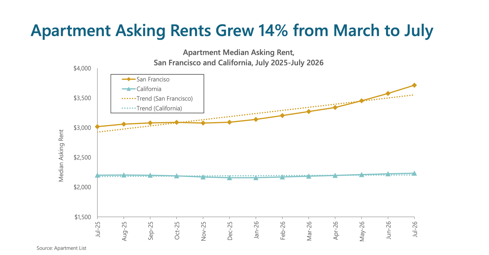
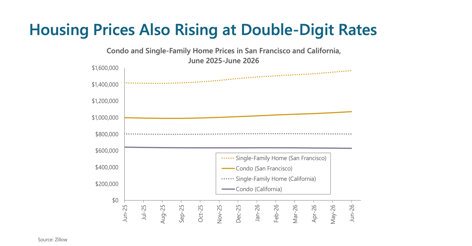
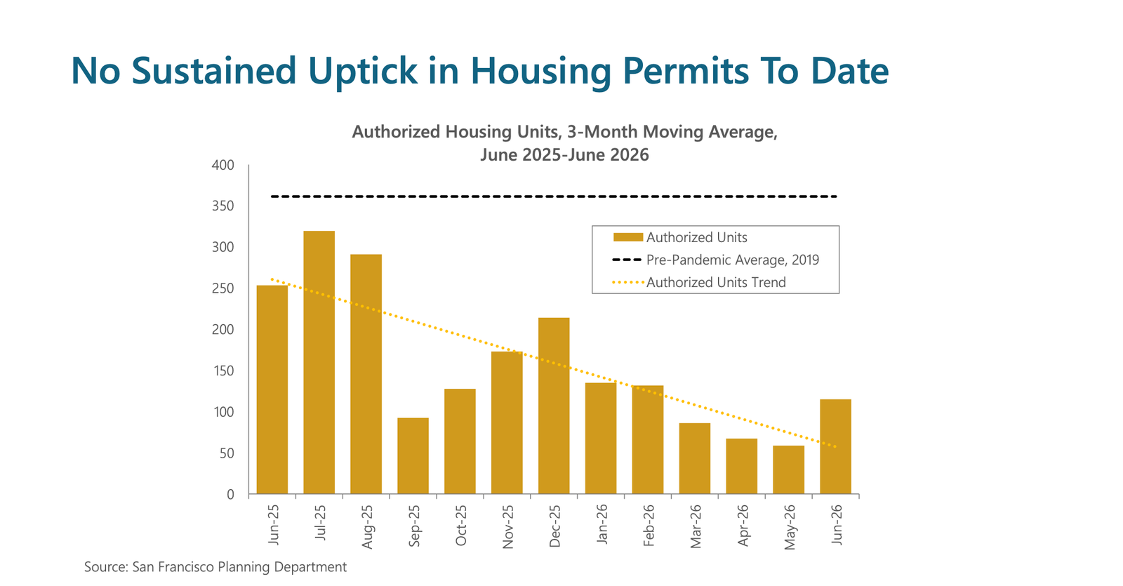
    Housing Supply Crisis: Residential apartment rents grew 14% from March to July, and single-family house prices are now growing at double-digit annual rates. And yet, the city continues to see a structural decline in housing permits, below pre-pandemic levels.

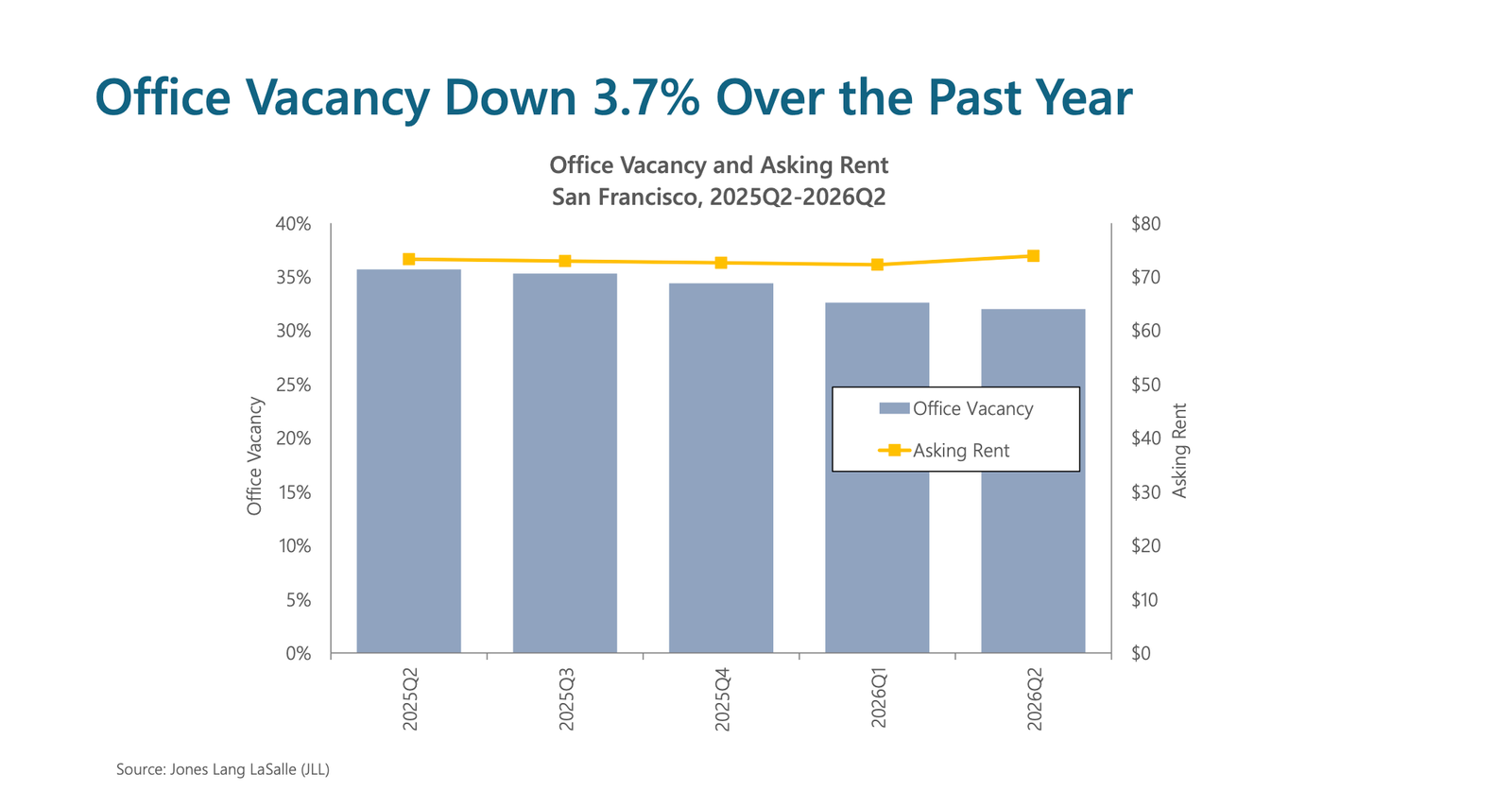
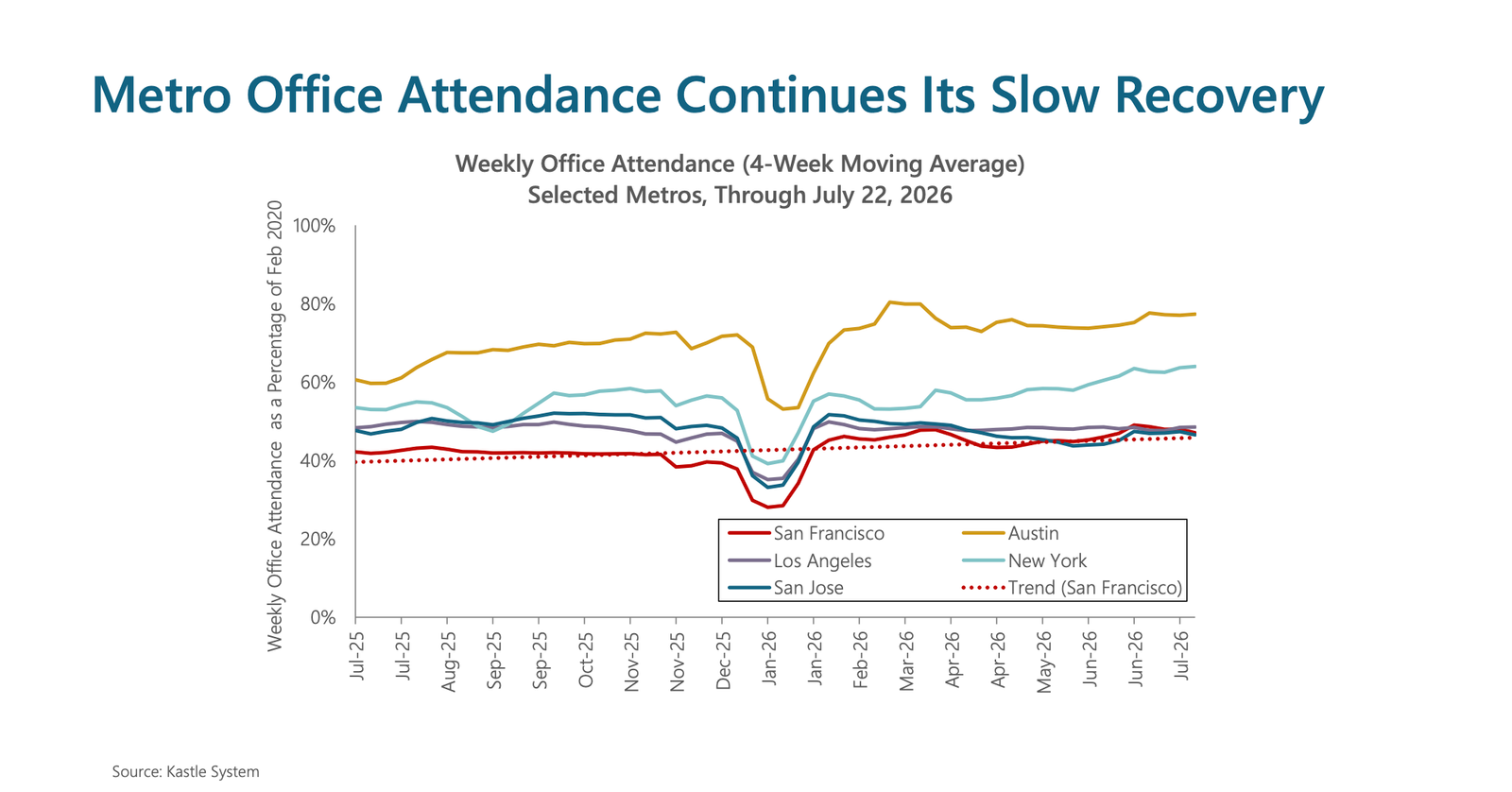
    Segmented Commercial Market: The city’s office vacancy rate declined 3.7% over the past year, but the overall vacancy rate is still greater than 30%. Weekly office attendance also remains below 50% of pre-pandemic levels.

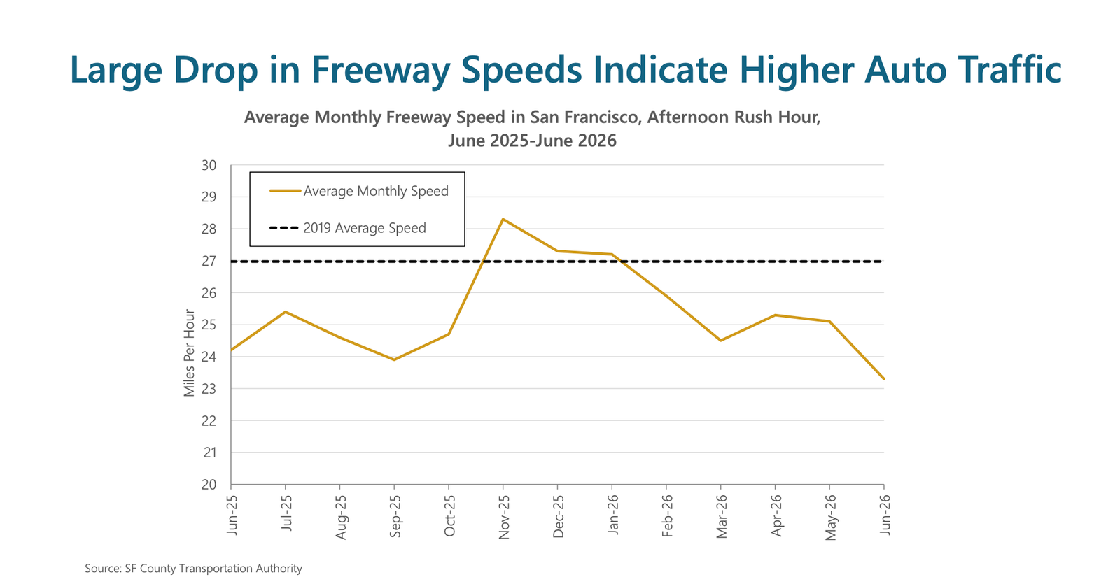
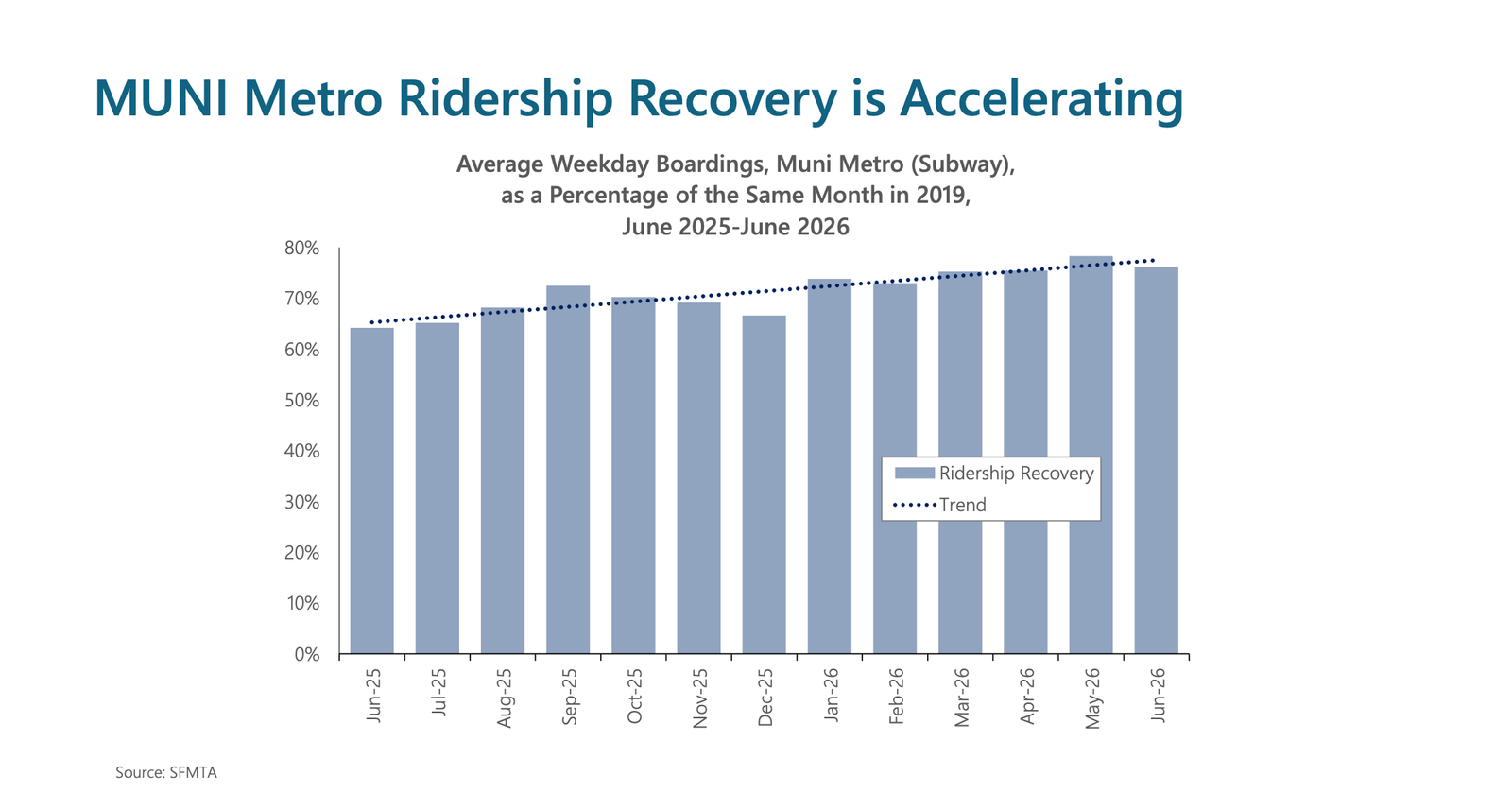
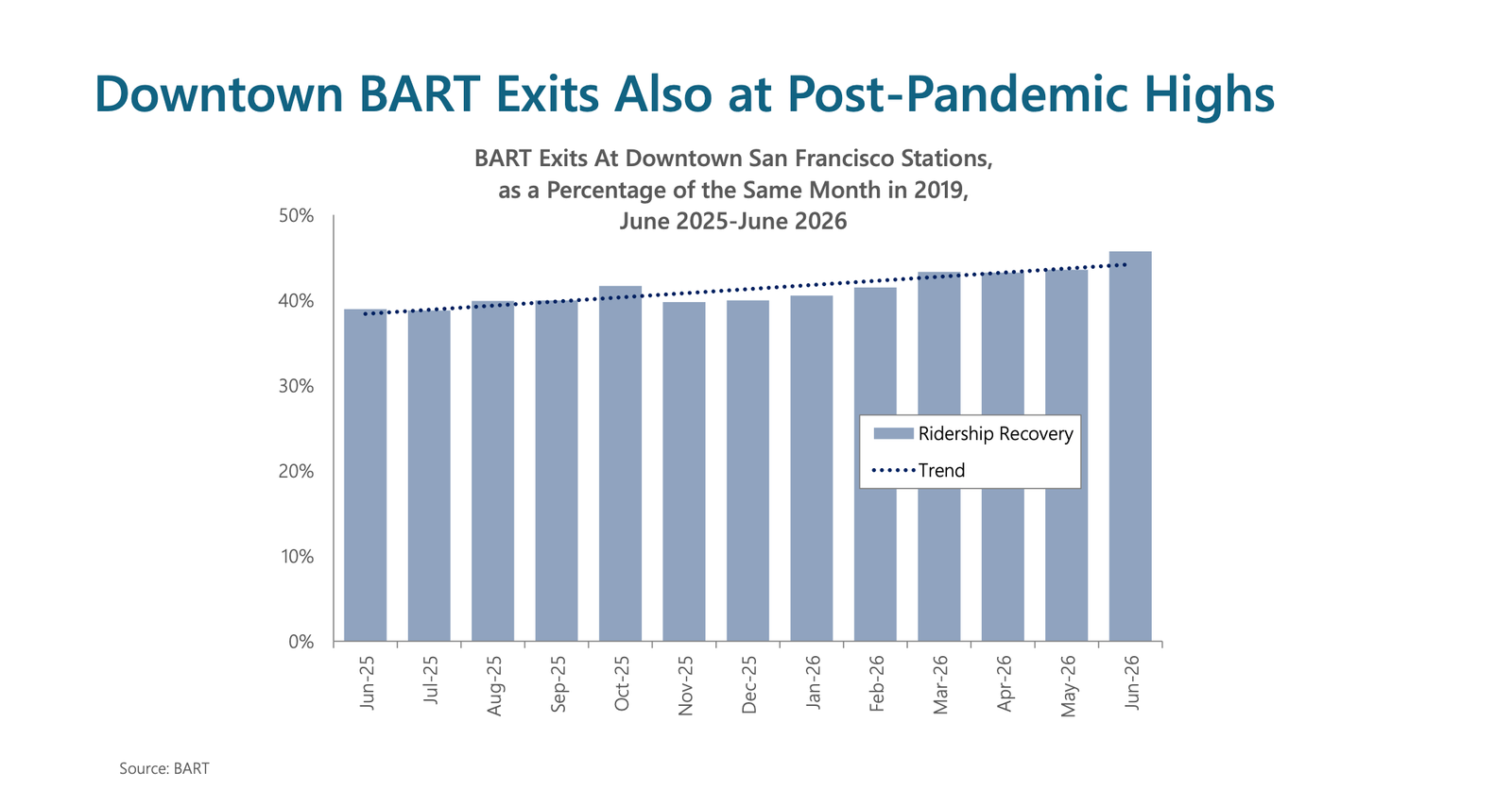
    Urban Rebound: Average highway speeds are dropping, suggesting more user demand. MUNI Metro (local) ridership is also increasing rapidly, reaching over 70% of pre-pandemic levels. But downtown BART station exits (regional rail) are below 50% of 2019 levels, reinforcing the fact that though the city is active, but people simply aren’t commuting in nearly the same way.

    Ultimately, the surge in housing prices proves that the “urban doom loop” narrative was fundamentally wrong (remember that?). San Francisco remains an intensely desirable place to live and work. But they’ve got to get moving on building more housing.

  • Squatters, not planners, created Bologna’s beloved porticoes

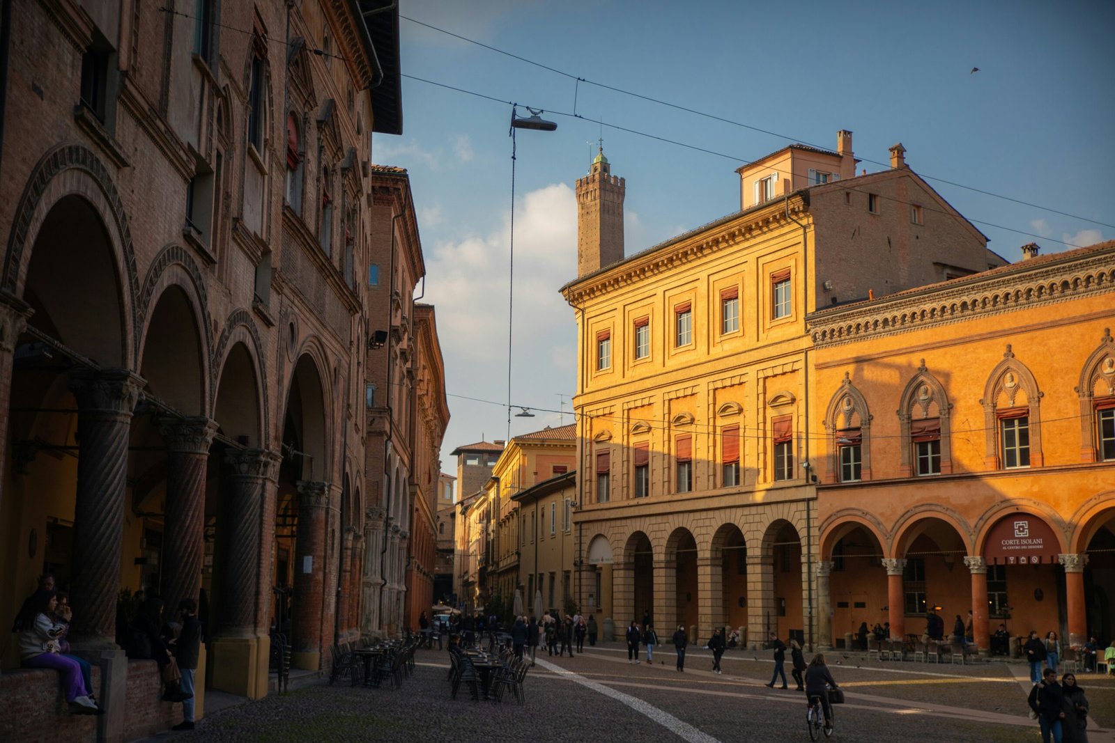
    Bologna, I’m told, is a city famous for its colonnades or porticoes. I’ve never been, but it’s a city that’s on my list. Bologna has 62 km of covered walkways, 40 km of which are in the city centre, and they are designated as a UNESCO World Heritage Site. They provide shade in the summer, and protection from rain during the winter. But how did this happen? What’s the legal structure underpinning them?

    Bologna’s porticoes go back roughly a thousand years and, interestingly enough, they are a result not of some grand, top-down master plan, but of a ground-up, market response. Bologna was a dense, walled city, with a growing population. Space was at a premium and so unscrupulous developers and landlords started encroaching into the public right-of-way and cantilevering their buildings outward. Few people were apparently fussed.

    The earliest evidence of a portico in Bologna seems to date back to the year 1041 — an example of private use of public land. But over time, the utility of these colonnades started to be more broadly appreciated. Not only did they protect pedestrians from the elements, but they allowed craftsmen to work outside of their workshops with natural light and with similar shelter.

    Gradually, porticoes became obligatory (at least in some areas and on some sites). This then transferred the porticoes from private use of public land to public use of private land. Developers were forced to build them.

    My understanding is that the vast majority of the porticoes exist today with this legal structure. The land is private, but the public enjoys an access easement in perpetuity. This means that private owners must pay to maintain these colonnades. It’s an example of what we often call here in Toronto a POPS space — a privately-owned, publicly accessible space.

    These spaces took many centuries to become codified, but what I find most interesting is that they are a product of ground-up innovation. A more contemporary example of this is Tokyo, which is often considered to be an example of bottom-up planning. Here’s a book on the topic called Emergent Tokyo — Designing the Spontaneous City.

    Turns out, Bologna’s beloved colonnades weren’t the product of visionary planning, but of Medieval squatters.


    Photo by Ryan Ladd on Unsplash

  • The Venice syndrome — or is it?

    We were walking through Old Nice today and we stumbled on a fresh pasta shop called Clé aux Pâtes (highly recommend). I went in to grab supplies for dinner and then started chatting with the friendly lady behind the counter. She explained to me that all of the pasta is made on-site every morning and that the shop has been there since 1932.

    I then made a comment that their customer base must have changed considerably over the decades. Underlying this statement was an assumption that it is now mostly tourists. But she corrected me and said that lots of locals also shop there. I then turned to look at the line behind me and, for what it’s worth, there was French being spoken.

    But I left thinking about the composition of the neighbourhood. Old Nice is made up of several statistical areas. The oldest and densest is called Vieux Nice-Sainte-Réparate. It’s just under 50,000 square metres, which is about the size of the Distillery District in Toronto. As of 2022, it had a total full-time population of 1,187 people. This works out to a respectable figure of 23,912 people per km2.

    However, the area’s population has been in decline since at least 2007, when it had 1,798 people. The obvious culprit is more hotels, short-term rentals, and secondary homes. I had Gemini review the area’s census data, and it estimates that only somewhere between 35-45% of the area’s housing serves as primary residences.

    This data would suggest that Old Nice is another example of what has been called the “Venice syndrome.” Tourism is now the trade, leading to a decline in population. But it’s interesting to think about the extent to which the area may also serve as an open-air mall for locals. That’s a more resilient place to be. Of course, all I have to go on is a pasta anecdote.

  • How do you make a street less touristy?

    La Rambla is arguably Barcelona’s most famous street. It’s a tree-lined street that runs 1.2 kilometres from the Plaça de Catalunya in the north to Port Vell in the south. Its origin dates back to the 15th century when the original stream was drained and the semblance of a street started to emerge.

    In the centuries that followed, the street came to serve as an important anchor for urban life in Barcelona. It provided a spine of open space within a dense medieval fabric of narrow streets. But alongside the rise of Barcelona as a global tourist destination, the street came to be seen more as a place for tourists than as a place for local urban life.

    This desire to create more “sustainable tourism” is one of the impetuses behind the ~€56 million revitalization project that is currently underway and is expected to be completed in 2027.

    But this raises a fascinating city-building question: How do you actually make a street less, you know, touristy? Tourists like visiting Barcelona and walking on this street, and so aren’t business owners going to just naturally cater to them? And aren’t landlords just going to rent to whoever will pay the highest rents?

    Here’s some of what Barcelona is doing:

    • Transversal flows: This one is fascinating to me. It was found that tourists tend to walk the street longitudinally (up and down), whereas locals tend to walk it transversally. In other words, locals are more likely to cross it coming from one of the surrounding neighbourhoods. The new design now privileges these more local flows.
    • Expanded pedestrian zones: Car traffic is being reduced to one 3.5-metre lane in each direction. This frees up more space for pedestrians, which is expected to help with overcrowding.
    • Room for culture: Dedicated spaces are being created to allow for more cultural programming. This is also part of a broader strategy to elevate the kind of tourism that the city receives.
    • Commercial licensing restrictions: As I understand it, the city is actively working to limit the licenses given out to souvenir shops (and the like) along the street. A meaningful amount of retail is also housed in kiosks and stands within the public right-of-way, where the city has even greater control.
    • Mercat de la Boqueria: One of the main anchors on La Rambla is the publicly owned market. But over the years, the product mix started to skew toward ready-to-eat foods and other to-go products designed for tourists. New restrictions have been put in place, or will be, that cap tourist-oriented offerings at 50%, allowing more space for local shopping needs. Interestingly enough, I have read that the merchants were in favour of this cap because the emphasis on tourist products was driving down margins. You instead want people coming in and grocery shopping for their families.

    These are just some of the initiatives that are being undertaken to rebalance La Rambla and find a more sustainable equilibrium between tourists and locals. It also dovetails with some of the other broader moves that Barcelona has implemented, such as its short-term rental ban and the right of first refusal (ROFR) that it enjoys over certain buildings and homes in order to grow the city’s public housing stock.

    It’ll be interesting to evaluate the effectiveness of these moves once the street is complete. La Rambla has many centuries of history and it has always evolved alongside Barcelona. Today is no different.


    Images from Barcelona City Council

  • Travel isn’t always pretty

    Sometimes there’s an elevator down to the metro, but more often than not there isn’t. 

    Sometimes there’s AC, but oftentimes there isn’t.

    Sometimes Vivienne is peacefully sleeping in her stroller or carrier, but sometimes she’s having a diaper blowout meltdown and screaming loud enough that passersby start giving concerned looks.

    Traveling can be positively inconvenient at times. We’ve never traveled with so much paraphernalia before. We’ve never had to keep breast milk chilled on ice and think about bottle expiries while navigating busy metro trains with no room for our stroller. 

    But in my mind it’s like exercising. It’s work, especially with kids, but it changes you for the better. We also want Vivienne to grow up to be adaptable, resilient and patient in the face of hot, urine-soaked transit elevators and the like.

    As Anthony Bourdain once said:

    “Travel isn’t always pretty. It isn’t always comfortable. Sometimes it hurts, it even breaks your heart. But that’s okay. The journey changes you; it should change you. It leaves marks on your memory, on your consciousness, on your heart, and on your body. You take something with you. Hopefully, you leave something good behind.”

    We finished our week in Paris, walking and taking transit everywhere. We didn’t step into a car once. We averaged just over 10k steps a day, which is significantly lower than what we would have done sans baby, but it’s still respectable. 

    Seeing the data on my watch and my surging step count reminded me how sedentary my life has gotten over the last two years while working from home (at least from a steps per day perspective).

    It’s unacceptable and I need to make some life changes when I get back to Toronto. But for right now, it’s time to head south.

  • Micro-retail on the corner of rue de Mogador

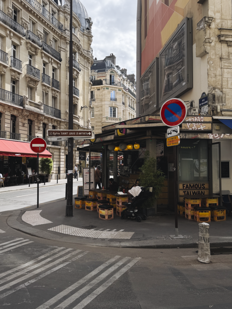
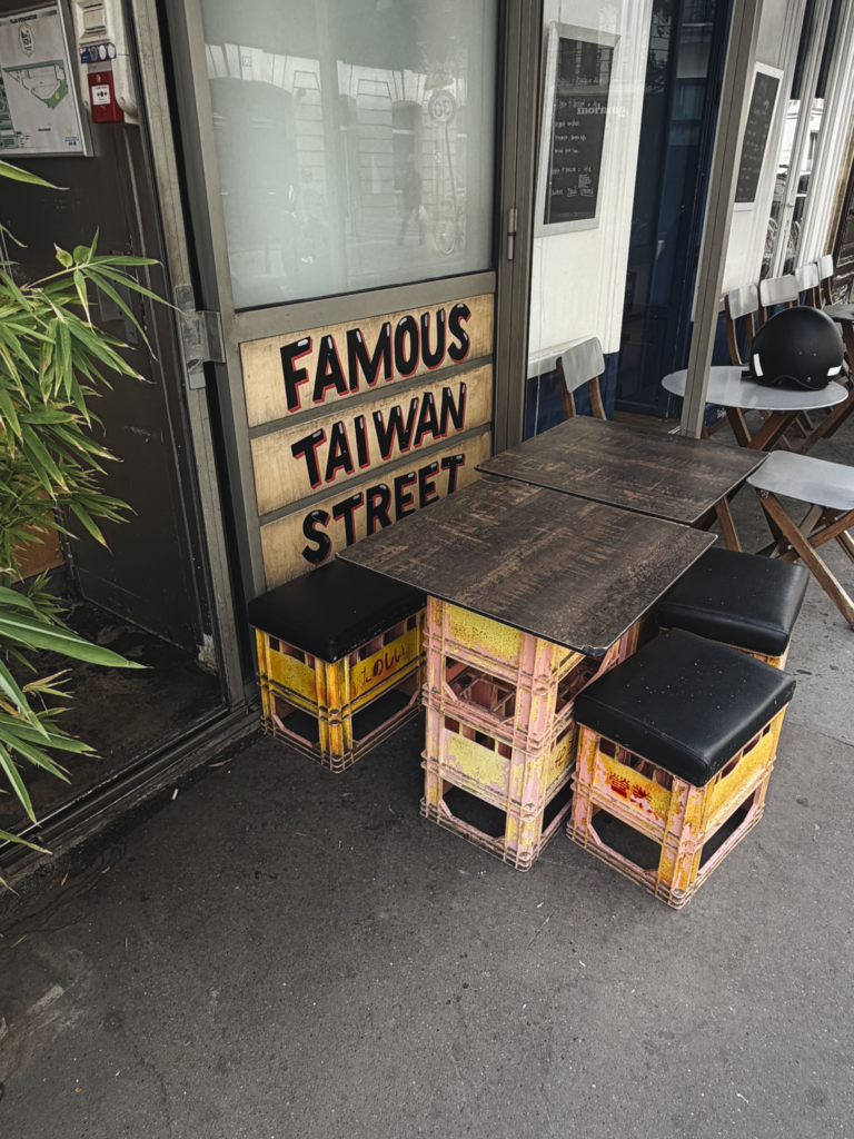
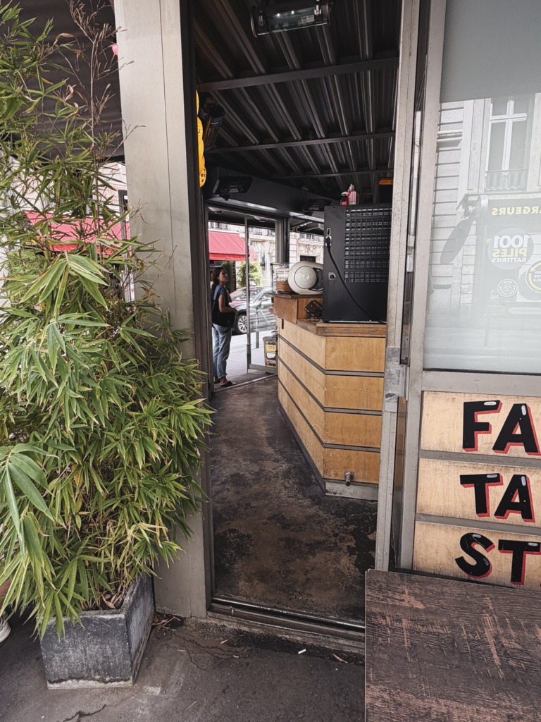
    This corner, the corner of rue de la Victoire and rue de Mogador in Paris, could have very easily been nothing. The side wall of the main building is, for whatever reason, blank. There’s a tall mural, two advertising billboards, and a remnant parcel of land that looks to be no deeper than about 3 metres at its absolute deepest.

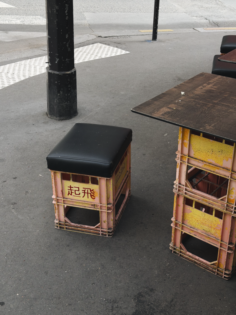
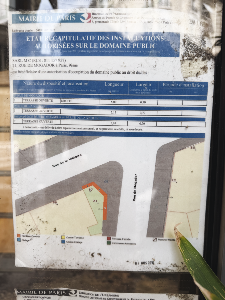
    But instead, you’ll find a Japanese street food restaurant called Mian Fan Onigiri (I’m not sure what the Taiwan sign is all about). The interior can’t be larger than 20 or so square metres, but it’s surrounded by a 0.7-metre-deep patio that wraps around the outside of the space and runs about 10 m in total along three faces (see city terrace permit document).

    It’s a simple and unfussy space. The patio consists of milk-crate furniture. But these kinds of small spaces punch well above their weight in what they contribute back to a city in terms of street animation and public life. Cities would do well to reduce the barriers to this scale of business and encourage more small entrepreneurs to hang a shingle.

    And until they do, we’ll never know how much of this urban spirit is being suppressed.

  • New acquisition for Globizen Flats: 571 Oakwood Avenue in Toronto

    This week, Globizen announced a new acquisition for our Flats division: 571 Oakwood Avenue in Toronto.

    This is an exciting moment for us because it marks the first project in our strategy of unlocking underutilized urban sites to create thoughtfully crafted, design-forward rental homes in walkable, transit-oriented communities across Toronto.

    The mission is simple:

    • Fill a Housing Need: We believe there’s a gap in the market for spacious, well-designed, family-oriented rental homes at accessible price points.
    • Support Toronto’s Urban Evolution: We believe that Toronto is at a unique turning point in its urban history, transitioning from a monocentric downtown surrounded by low-rise suburbs to a polycentric city that fundamentally rethinks its relationship to the car.
    • Invest in Renewable Energy: Canada needs more clean energy capacity. We see this as an opportunity to create a decentralized renewable energy asset alongside our communities.

    Globizen Flats is a response to these beliefs.

    Check out the full post in the Globizen Journal. You can also subscribe and follow Globizen Flats (@globizenflats) on Instagram.

    As an aside, I initially created the above toilet image as a joke. It’s a photo of the bathroom in the existing house on site. But my partners thought it was cool and that we should share it publicly, so here we are. I bet that toilet was the neatest thing when it was first installed.