Daily insights for city builders, delivered every morning at 6 AM ET. I’m Brandon Donnelly — a Toronto-based real estate developer and founder of Globizen. I’ve been writing here since 2013.

Category: Planning

  • Toronto’s highway 407 is doing what it is supposed to do

    In Google’s guide to its maps, there is a section on live traffic congestion, and in it, this image is used:
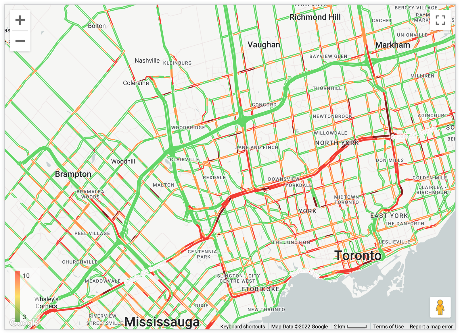
    It is a map of the Toronto region, and not surprisingly, it is showing traffic congestion on the 401 highway. But what’s interesting about this image is that there’s no traffic at all on the 407 express toll route. (This is the green highway running generally parallel and north of the 401, for those of you who aren’t familiar with Toronto.)

    This is, of course, accurate. A 2019 study by the Canadian Centre for Economic Analysis called the Economic Impacts of Highway 407 found that, at the time, an average of 413,000 drivers were using the 407 highway each weekday. And of these trips, more than 85% of vehicles were travelling at or above 100 km/h. This translates into a traffic congestion index of almost zero.

    During this same time, the highway 401 through Toronto showed that about 85% of vehicles were travelling below 50 km/h. Meaning, lots of congestion. This also had a significant impact on collision and fatality rates. On the 407, both were about half of what they were on the 401. (I couldn’t find any more decent data, but if you have it, please share it in the comments.)

    The reason for these differences is simple: the 407 charges for congestion. Here are the current per kilometer weekday rates for light vehicles travelling westbound:

    Naturally, there are people who think the 407 is too expensive and that it shouldn’t have been privatized. But the reality is that it works; really well in fact. And this is the only method that has been proven to reliably combat congestion. We can go ahead and spend a gazillion dollars building a new tunnel under the 401, and double the number of lanes (it’s already 18 lanes at its widest point), but we already know that it won’t solve our congestion problem.

    Either we price roads and congestion, or we don’t. But if we don’t, then we need to be brutally honest with ourselves about the economic trade off that we are making: free/underpriced roads = traffic congestion, and accurately priced roads and congestion = less traffic. The choice is ours. But know, there’s no such thing as a free lunch.
  • The Bentway Islands

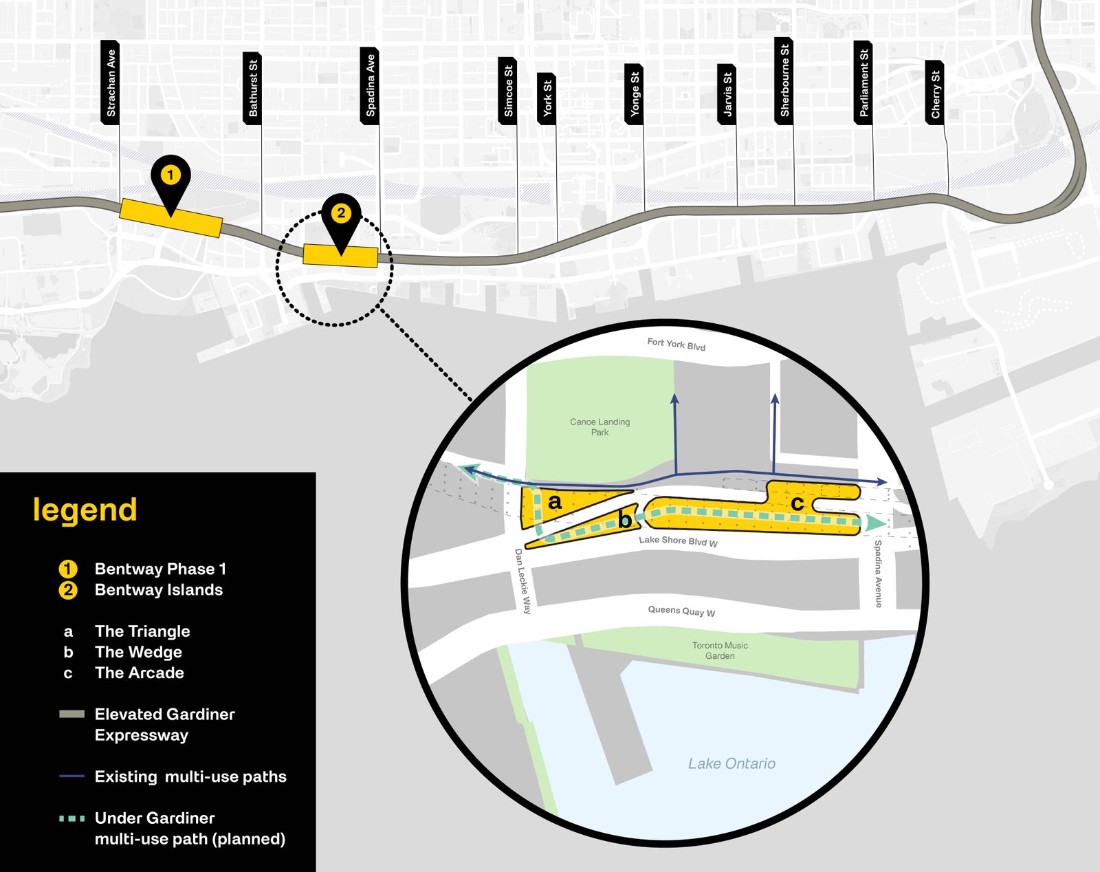
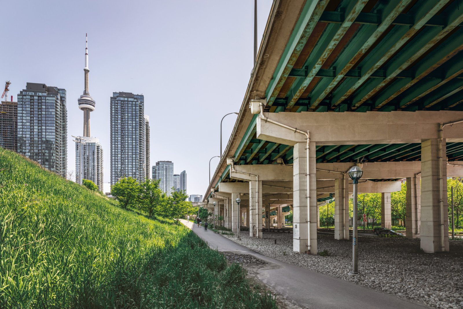
    As many of you know, Toronto has a highly successful public space underneath the Gardiner Expressway called The Bentway. I have ice skated in this space during the winter and I have listened to hard techno in this space during the summer. It has become a public space anchor in the city. Ilana Altman and the team are doing great work. And this week, they just announced that Field Operations (New York) and Brook McIlroy (Toronto) have been hired to design a major expansion. Called The Bentway Islands, this next phase consists of three “islands,” totalling 11,500 m2 (~125,000 ft2).

    Here’s a map:

    And here’s what the spaces look like today:

    Both of these firms do fantastic work, and so I’m excited to see what they come up with. (Field Operations is the firm behind New York’s High Line.) But if I can offer two unsolicited (yet related) suggestions, they would be: 1) Let’s incorporate more commercial uses and 2) let’s aim for these three parcels to not actually feel like urban islands. Generally speaking, the spaces underneath highways aren’t the most desirable. They also tend to be surrounded by inhospitable urban environments. Stitching them in and creating continuity in the fabric of the city (existing example, here) is the best way to make the highway above more or less disappear.

  • Mapping 15-minute cities

    This is an interesting map to play around with. It allows you to see how many 15-minute neighborhoods and cities there are around the world. And it works by calculating the average time it takes to walk or bike to the closest 20 points of interest in 10,000 cities. These points include all of the usual suspects like places of work, schools, healthcare institutions, grocery stores, and so on. A blue cell indicates an average walk time < 15 minutes, and a red cell indicates an average walk time > 15 minutes. The darker the color, the shorter or longer the average time in minutes.

    By this measure, it’s hard to beat many/most European cities. Here are Paris and Barcelona:

    The city propers are completely blue, and you have to go pretty far out (or up into mountains) to find areas that don’t have 15-minute conveniences.

    Toronto has a strong core and isn’t terrible overall, but expectedly, we aren’t as uniform and as deep blue as Paris and Barcelona:

    Where things get really interesting, though, is when you look at cities like Dallas and Houston:

    It’s clear where these cities stand on walkability.

  • Rent control and road pricing — economics is the study of choice

    Yesterday’s post tried to pit politics against the realities of how we know cities and economics work. So today, I thought I would share a set of memos from Howard Marks (of Oaktree Capital) titled Economic Reality, Political Reality (which he refers to as an oxymoron), and Shall We Repeal the Laws of Economics?

    In this last one, he specifically talks about things like price gouging (starting with the grocery industry) and apartment rent controls. Each is worth a full read when you have the time, but here I’ll leave you all with a few city building-related thoughts.

    Marks describes economics as the study of choice. And within these choices, there are many complicated moving pieces and second-order consequences. Take, for example, rent control in New York City. What rent control does is stop the free market from being able to freely set rents. The result:

    A person in favor of this arrangement would argue that it maintains affordability and diversity. What it means in purely economic terms is that some people who couldn’t afford to live in New York City if rents were set by free-market forces are able to live there if they’re lucky enough to secure an apartment with regulated rent. But other people who would like to live in New York City and can afford higher rents can’t do so because there are no apartments for them. And lastly, landlords that have apartments that are somehow unregulated can command higher rents than would be the case if additions to the supply of apartments weren’t being discouraged. It’s a matter of personal philosophy whether this is good or bad. But clearly, the laws of economics and the actions of free markets aren’t at work in New York City. Someone in government is making the decisions.

    Much like inclusionary zoning in the case of new housing, the tradeoffs with regulated rents are that you get (1) less overall housing supply and (2) more expensive prices for the people that can pay market rents.

    You could argue, as Marks suggests, that these are acceptable outcomes; but regardless of your opinion, there are real consequences to this policy decision. There’s no such thing as a “free lunch” in economics, and consequently there’s no such thing as no-cost affordable housing. The question is: Who pays?

    Going back to the topic of traffic congestion from yesterday’s post, Toronto’s general reluctance to implement any form of road or congestion pricing is also an economic choice. We have priced our roads so cheaply that demand is always going to outstrip supply. And this is expected. What we are experiencing today is a natural market outcome.

    Targeting bike lanes as part of the problem is meant to counter this by increasing road supply. Less bike lanes means more space for cars, right? But the second-order consequence of this choice is that you push people off their bikes (which take up less road space) and into cars (which take up more road space). So demand is also likely to increase.

    The stark reality of solving traffic congestion is that it will require greater change. It will mean fewer people driving, more people taking transit and biking, and the people who do continue to drive will have to pay more for it.

    Of course, this is not what any politician wants to talk about. As Marks says: “In the world of politics, there can be limitless benefits and something for everyone. But in economics, there are only tradeoffs.” The tradeoff we have decided to make is cheap roads in exchange for crippling traffic congestion.

  • Toronto’s congestion crisis needs solutions, not politics

    People in Toronto are deeply and rightly frustrated about our traffic. We have truly world-class congestion. But here’s the thing, the way we’re going about solving this problem is all wrong.

    Transportation staff seem to believe that congestion charges would not reduce or deter traffic from coming into Toronto. Never mind all the global precedents, never mind that we have the tolled 407 highway to look to, and never mind that economics tells us that when the price of something increases, the quantity demanded decreases.

    Instead, we seem to think that we can solve this problem with fewer bike lanes, improved traffic management, and better policing, including higher fines for disobedience. (Interestingly enough, higher fines are supposed to deter people, but congestion charges won’t do the same. I’m confused.)

    None of this will fix the mess we’re in.

    This is a case of politics over data and experience. Identify something that people are pissed off about, and then create the illusion that you’re doing something to fix it. Good politics. But the reality is that this problem is much trickier to solve. It will require vision and meaningful change. That’s a much tougher sell.

    Think of this way. Can you identity a large car-oriented global city with millions of people that doesn’t have a traffic congestion problem? Even the Katy Freeway in Houston, which counts as many as 26 total lanes, has a congestion problem. And the last time I checked, it didn’t have any bike lanes.

    https://twitter.com/joshuahind/status/1837347617304424620

    Now let’s look at the largest city region in the world — Tokyo. The city proper has about 14 million people and the broader region has about 41 million. This is the entire population of Canada in one city region, and yet it’s generally viewed as being one of the most well-run and efficient cities in the world. How do they do it?

    Here are the modal splits within Tokyo’s 23 wards (2018 data):

    • 36% public transport (rail and bus)
    • 27% passenger cars
    • 23% walking
    • 14% bicycles and motorcycles

    Now compare this to the splits in Toronto’s census metropolitan area (2021 census data):

    • 76% passenger cars
    • 16% public transport
    • 5% walking
    • 1% bicycles
    • 2% other

    Of course, if we were to look at the modal splits within the core of the city they would look quite different and much closer to Tokyo’s numbers. This is why it can be so hard to achieve consensus on many city building issues — we are quite literally a divided and different kind of city.

    In the end, this is the root cause of our traffic problem. The vast majority of people in this city region drive. And they are not to be blamed. It’s because we’ve designed this to be the only practical option.

    But if we’re serious about solving congestion, it’s going to require some bold changes. It’s going to require reducing this 76% figure. We can fool ourselves into thinking that better construction coordination, fewer bike lanes, and higher fines will somehow solve this enormous and deep-rooted problem, but the inconvenient truth is that they won’t.

    What we need are real solutions. Is anyone going to take the lead?

  • Toronto is looking to remove garden suite zoning permissions from this street

    Toronto has been making great progress when it comes to allowing more housing in its low-rise neighborhoods. We now allow laneway suites, garden suites, multiplexes, and soon we’ll allow 6-storey apartments. But interestingly enough, there is one small part of the city that is looking to regress. This past summer, council asked planning staff to bring forward a zoning by-law amendment to remove garden suite permissions for some of the properties backing onto Craven Road, near Danforth and Coxwell.

    Here’s a community consultation flyer that went out to residents and that shows the affected properties:

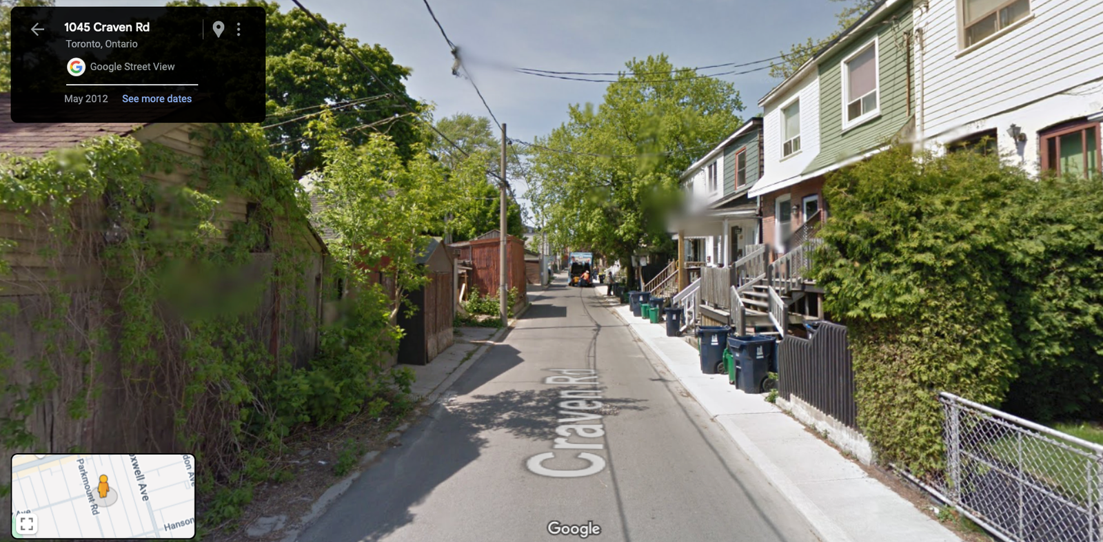
    We’ve spoken about Craven Road before. It’s a relatively odd street with a unique history. Its most obvious characteristic is that it’s a kind of single-sided street. For the most part, there are homes on the east side of the street, but no homes on the west side. On the non-home side there is typically a garage, or the longest municipally-owned fence in the city. Here’s some of the backstory on Craven Road’s infamous fence (which occurs on a stretch further south), and below is what the study area in question looks like today:

    So why remove the garden suite permissions here? The answer is to block housing. The people who live on Craven Road like it the way it is and don’t want anyone to build new housing on the other side of the street. What’s interesting about this is that it roughly mirrors what happened over a century ago. We couldn’t figure out how to broker a deal between two adjacent streets and so we just said “screw it, let’s build a really really long fence and call it a day.”

    Today we’re saying, “yeah, we really need more housing in the city, but I dunno, somebody might get upset here.” There is nothing sacrosanct about the old garages, or the fence, that line the west side of Craven. It is a street, proximate to a major subway station, that is missing homes on one entire side. It’s low hanging fruit for infill housing. In fact, there’s an easy argument to be made that garden suites aren’t nearly enough density for a location like this. We should be encouraging a lot more.

    But this is just my opinion. If you’d like to share yours, the City of Toronto is hosting a community meeting this week on September 19, 2024 from 7 – 830 PM. To participate, register here.

  • Density vs. infrastructure in Liberty Village

    A beautiful new 43-storey rental building was just approved in Toronto’s Liberty Village neighborhood. More info about the project can be found, here. Not surprisingly, some people in the community were against it. Here is a recent article that blogTO published talking about people who live in high-rises not wanting a new high-rise next to them.

    One argument that is being made is that the neighborhood is already full. It has reached its density limit. We also hear this about the City of Toronto as a whole. But we know this isn’t true. Architect Naama Blonder recently did a study that found we could fit another 12 million people within our boundaries with more efficient land use policies.

    This particular site in Liberty Village is also about 400 meters from a future subway stop on the Ontario Line. So it is exactly where we should be putting more density. The problem today is that the area is suffering from a massive infrastructure deficit. The road network is inadequate and the King streetcar hasn’t been prioritized.

    It’s no wonder the area feels full. But the reality is that there are lots of examples of highly livable neighborhoods from around the world with much higher population densities. The difference is that they have the right infrastructure, the right public realms, and the right modal splits.

    Liberty Village will get there as well and it’s already underway. For a preview of the future, check out the City of Toronto’s Public Realm Strategy for the area. It was published in April 2024 and it includes things like new streets, new mid-block connections, and new parks. It is what the area needs and it’s exciting to see it happening.

  • Physical space is a funny thing

    It is often difficult to grasp. This is why when you look at an empty piece of land, it can sometimes be difficult to visualize actually fitting a building on it. And why when you look at an empty room, it’s common to think, “there’s no way that furniture will fit in here.” But in the end, it does fit.

    It also tends to be relative. Here in North America, it is common to argue over things like parking space dimensions and drive aisle widths. We’ll say things like, “well, people like their big cars.” But then you travel to Europe and you find streets like this:

    And this:

    The first is only marginally bigger than the width of a parking space in Toronto (2.6 meters). And the latter is only marginally bigger than the width of a typical two-way drive aisle (6 meters). So are these too small? Well, it depends on your perspective.

    If your basis of measurement is the size of cars, then these streets will seem too small. Cars also keep getting bigger, so you have this inflation factor to deal with. But if your basis of measurement is something else, such as walkability, then maybe they’re just right.

  • New On the Bench website

    The Project Bench team spent the last several weeks capturing photos and videos of Canada’s largest wine region — the Niagara Benchlands (link is to the official tourism website). And today I’m excited to share that we’ve launched our own new placemaking website called On the Bench.

    The purpose of the site is to help celebrate the region. There’s also some very preliminary information about Project Bench. In our humble opinion, we don’t feel that the Benchlands region receives the attention that it clearly deserves. More people are familiar with Niagara-on-the-Lake and Niagara Falls, especially globally.

    The Bench is a distinct area, with its own unique character and with more — and arguably better — wineries. This v1 website is the start of us working to demonstrate this. So if you’re a local business or community member that would like to collaborate with us on this overall initiative, we’d love to hear from you.

    To join the Bench community and be first to learn more about Project Bench, email subscribe at the bottom of the page, and follow us on Instagram and X.

  • The mighty bollard

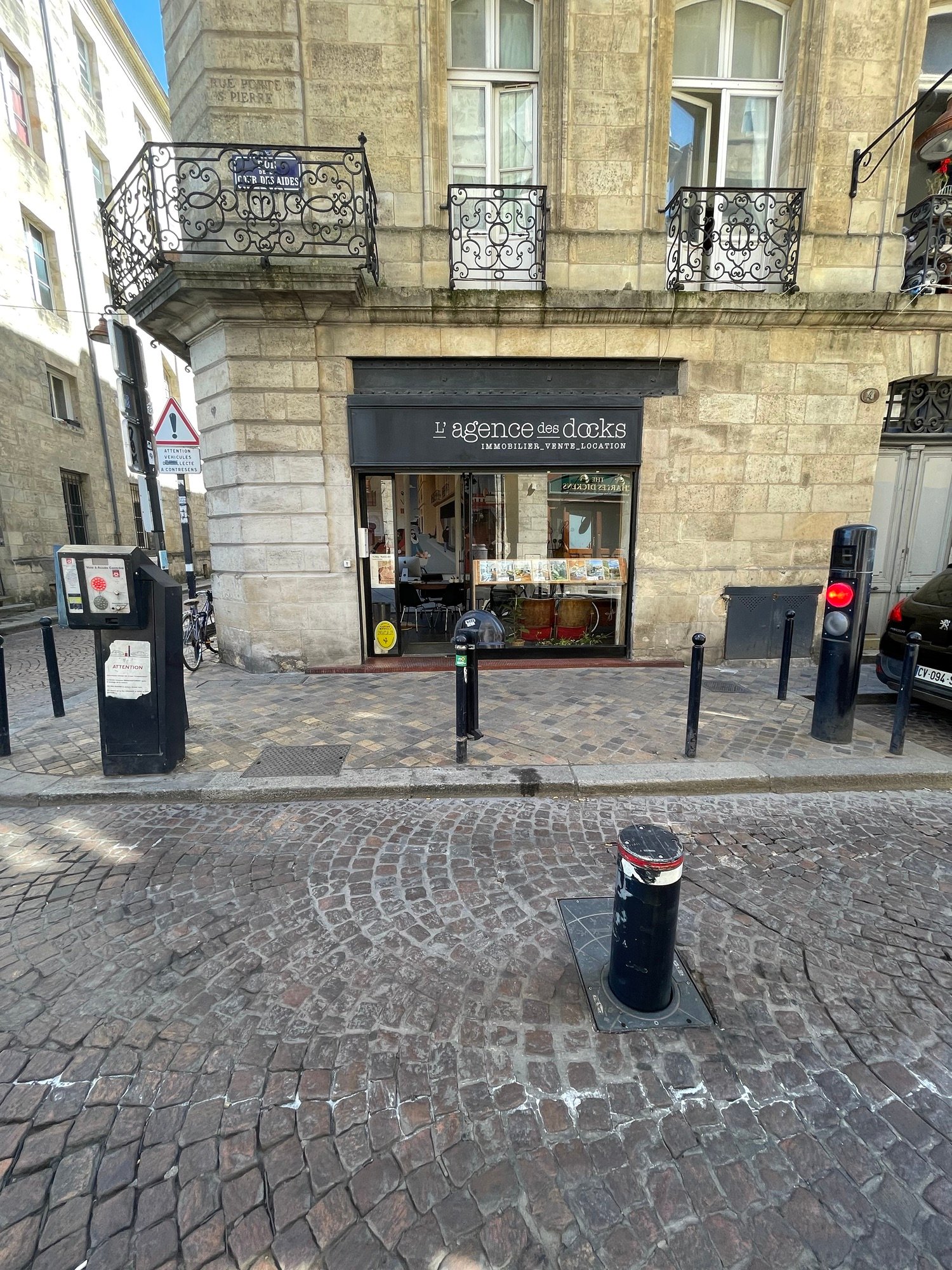
    The mighty — and automatic — bollard is an important city-building tool that isn’t employed nearly enough in North America. It’s typically used to control car access to small pedestrian-only or pedestrian-first streets. But I guess if you don’t have any of these, then you may not feel the need to install such a device. The above photos are from Bordeaux. And if you want to gain access, you need to hit the intercom button and explain why you’re local traffic. Can you think of any streets in your city that could use a system like this? I can think of many in Toronto.