Daily insights for city builders, delivered every morning at 6 AM ET. I’m Brandon Donnelly — a Toronto-based real estate developer and founder of Globizen. I’ve been writing here since 2013.

Category: Planning

  • La médina de Marrakech

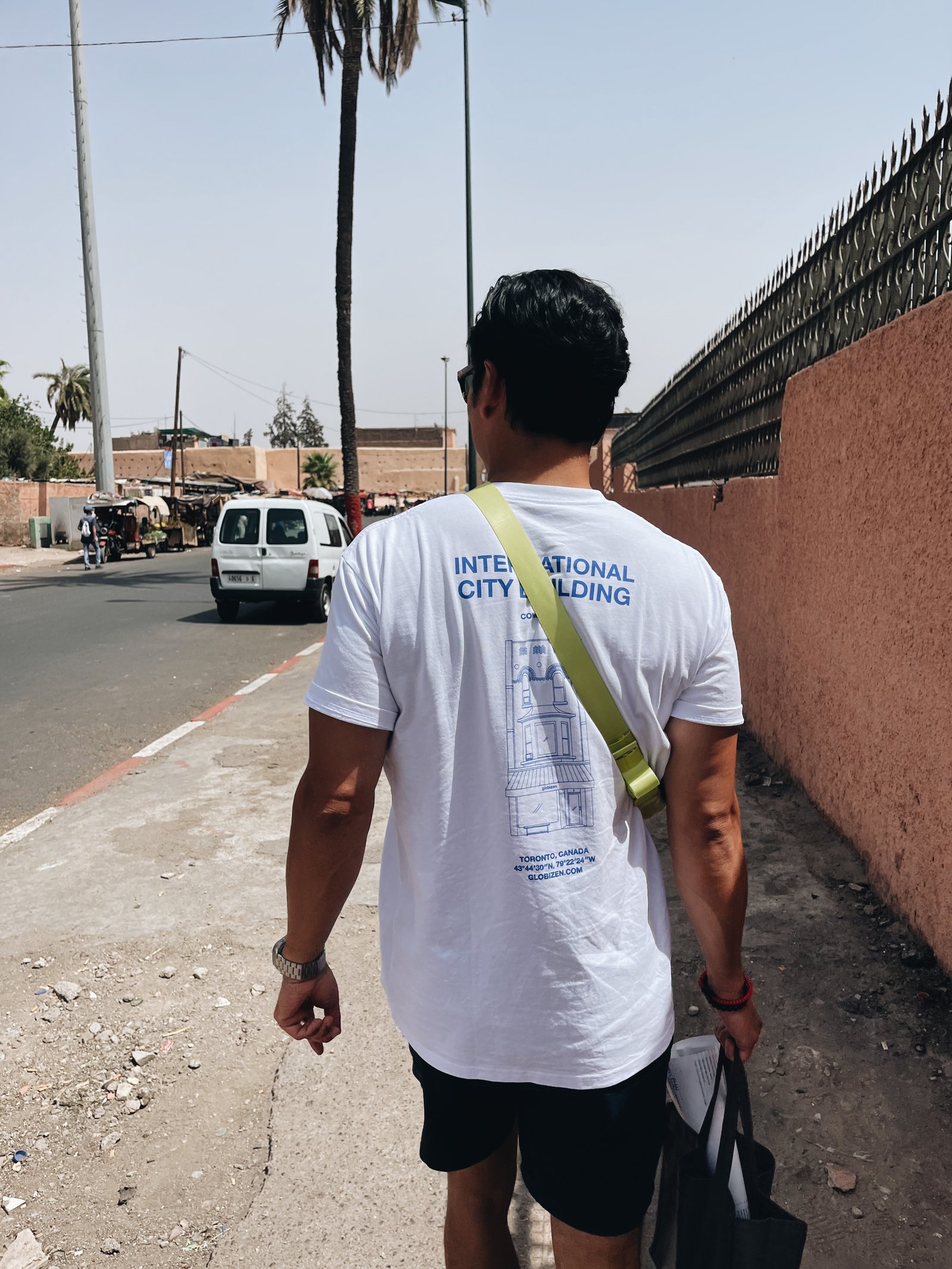
    Marrakech is one of the most frenetic, vibrant, and exciting cities that I have been to in a long time. Walking through the Medina means walking on streets that are only a few meters wide, but that are still somehow filled to the brim.

    Filled with a beautiful cacophony of people, smells, and merchants, selling everything from leather sandals to engine parts. Filled with an endless supply of people vying aggressively for your attention (and who all seem to coincidentally have a relative in Toronto). And filled with motorbikes that are liable to ride over your feet if only you let your guard down for a second.


    Sensory overload. It is at the same time exhausting and one of the coolest experiences ever.

    Another name for these streets would be “shared streets,” which is a way of saying that the formal distinctions between areas dedicated to pedestrians, cyclists, and motorists have been removed. While they are intended to be pedestrian-oriented, the overall approach is that all users just, you know, figure it out. Today, this is viewed as an enlightened approach to street design. Though it’s clearly not a new one.

    I will, however, be the first to admit that it’s easy to feel like an uptight Canadian in the Medina of Marrakech. This thought definitely crossed my mind: “I can’t believe they let motorbikes rip through these tiny streets.” You can see why somebody at some point felt it might be a good idea to carefully segregate uses.

    At the same time, the architecture of Morocco feels like the perfect complement to these chaotic streets. Notably inward facing, the central feature of a traditional riad is its courtyard. These spaces offer much-needed protection from the hot Moroccan sun, but they also allow for family privacy, which is something that is important in this culture.


    The result is that you immediately feel it every time you walk inside. You have now entered a beautiful and calm oasis in the middle of a frenetic and exciting city.
  • For visiting only

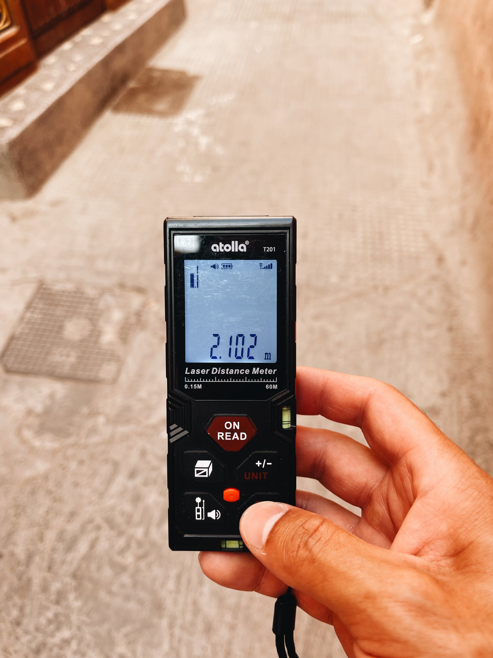
    The street in front of our hotel is about 8.3m wide. (I actually measured it.) And this is generous for Palma’s Old Town. The building directly in front of us is also 6 storeys tall and has exactly zero setbacks and stepbacks. It is one straight elevation all the way up. In other words, it is an urban condition that does not follow any of today’s generally accepted rules of planning. The street should be wider. And the building should have a bunch of stepbacks, right? Maybe not. Lots of people seem to love this kind of dense, unplanned, and walkable built form in Europe. Eating outside on a narrow street is a feature. But for whatever reason, when people return home, many don’t seem to want it anymore, or worse, they actively oppose it. It’s an interesting dynamic that I don’t fully understand. Because personally, I enjoy visiting places that I could see myself living in. What about you?

  • La Rambla

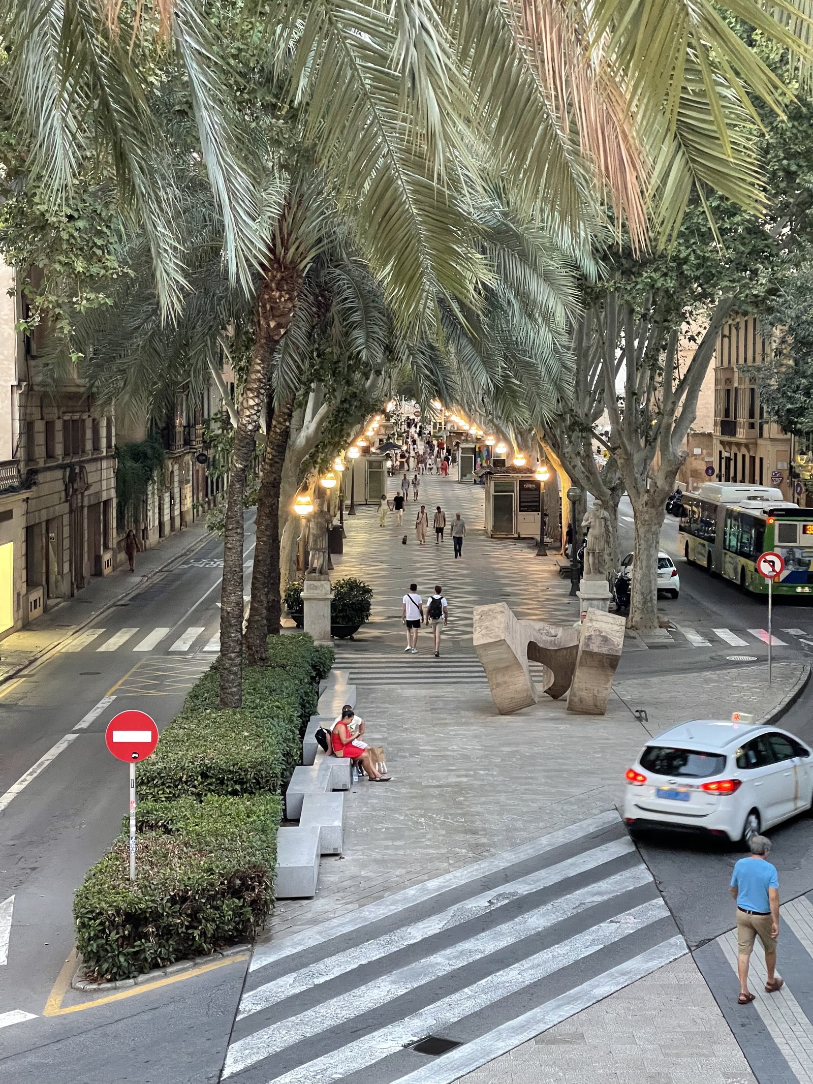
    It’s hard to think of Barcelona and not think of its famed street, La Rambla. But this same street design (and name) also appears in other cities throughout Spain. The above two streets are in Palma. The first is also called La Rambla (which is supposedly derived from an old Arabic word meaning sandy riverbed) and the second is called the Paseo del Borne. Both follow the exact same urban design principles. They’re broad tree-lined streets with a large center median dedicated to only pedestrians. All car traffic is relegated to the sides. What’s great about this design is the following. One, it reallocates public space according to who uses it the most (i.e. pedestrians). Two, it consolidates the main pedestrian realm (in lieu of just having larger sidewalks on either side of the street). And three, it establishes a clear hierarchy for the street. Pedestrians are most important here, and that’s why they get the center position. It’s surprising that more cities don’t adopt this same design.

  • Roncesvalles is a great, single-sided, street

    Roncesvalles Avenue is a successful north-south main street in the west end of Toronto. I say successful, because it is truly a great street. It has transit, bike lanes, a fine-grained built form, and lots of interesting retail:

    But it is somewhat unique in that a large section of it is a one-sided retail street. Meaning, it looks like this:

    This obviously isn’t a fatal flaw. It remains a wonderful street. And there are lots of examples of thriving one-sided retail streets. Ocean Drive in Miami Beach immediately comes to mind (notwithstanding the fact that locals tend not to go to it).

    But conventional retail wisdom does dictate that two sides are better than one. Consider this 2023 report by Cushman & Wakefield ranking the top global main streets across the world. All of the streets that I have been to before are two-sided:

    • 5th Avenue in New York between 49th and 60th (above 60th is, incidentally, when the street converts to single-sided because of Central Park)
    • Montenapoleone in Milan
    • The main street of Tsim Sha Tsui in Hong Kong
    • New Bond Street in London
    • Avenues des Champs-Élysées in Paris
    • Grafton Street in in Dublin
    • Passeig de Gracia in Barcelona
    • Bloor Street in Toronto

    These are all two-sided retail streets.

    None of this is to say that the west side of Roncesvalles has nothing going on. It has a diverse mixture of uses, including churches, libraries, apartments, and many other things. But I think there is still an argument to be made that it has been hamstrung by restrictive zoning.

    That said, Roncevalles is defined as a “major street” in Toronto’s Official Plan and so it does fall under the city’s new Major Street Study. Maybe that changes things.

  • Blocks and superblocks in Barcelona and Salt Lake City

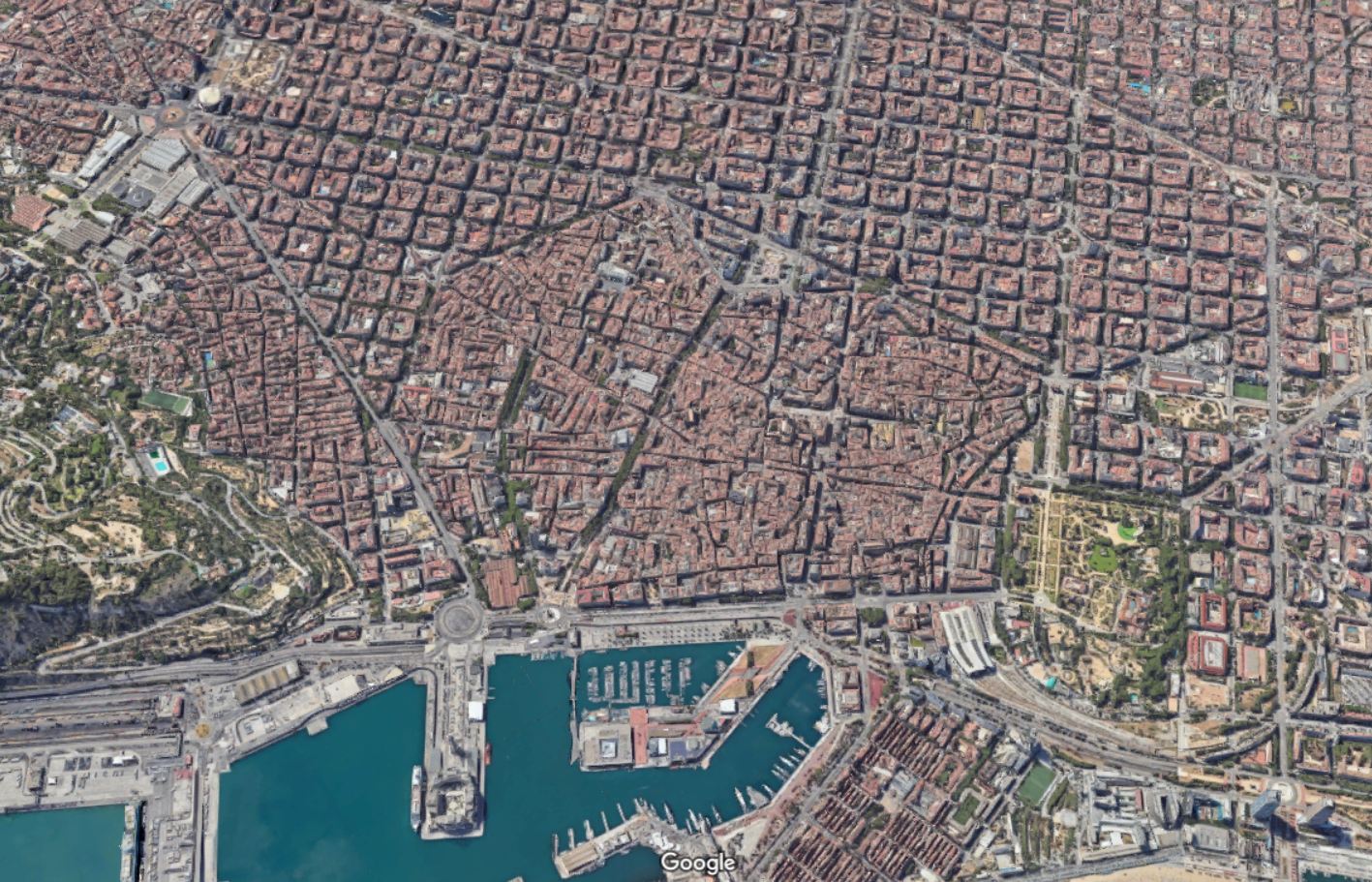
    Let’s continue with our theme of city blocks and talk about another city with a noteworthy street grid: Barcelona. Up until the middle of the 19th century, Barcelona was a tiny medieval city hemmed in by 6 km of walls and totalling just over 2 square kilometers. If you look at a map of the city today, it’s pretty easy to see where this was:

    This was of course done for military purposes. Barcelona’s medieval walls helped the city resist siege after siege. But the result was also overcrowding, unsanitary conditions, and a generally low life expectancy. So after much debate, it was eventually decided that the walls would need to come down and that the city would need to expand outward.

    This then raised the question: how should it be done?

    Enter a civil engineer named Ildefons Cerdà. Created in 1860, the Cerdá Plan for Barcelona was a continuous grid of blocks intended to guide the future growth of the city, similar to what the Commissioners’ Plan did for Manhattan. The blocks measured exactly 113.3 by 113.3 meters and each was to have a central open space of at least 800 square meters.

    In his original plan, the streets were to be 35 meters wide. But supposedly these were narrowed to no more than 20 to 30 meters due to criticism from the public. Wide streets and more lanes were, I guess, not seen as a benefit in the second half of the 19th century. Either this, or landowners simply wanted bigger buildings.

    The Cerdá Plan got approved in 1860 and, today, the city looks like this:

    One particularly unique feature of this plan was that the blocks all had/have chamfered corners. This improved visibility at the intersections, as well as created opportunities for public spaces and other uses. For better or for worse, today, you’ll find parking for cars and scooters, bike share stations, ramps leading to underground garages, patios, and more.

    The heights of the buildings on each block were also intended to be capped at a consistent height. But even with relatively few tall buildings, the Cerdà Plan led to one of the densest cities in Europe. Today, it is also viewed as a highly livable and desirable city. Hence why the city announced a total ban on short-term rentals. Too popular.

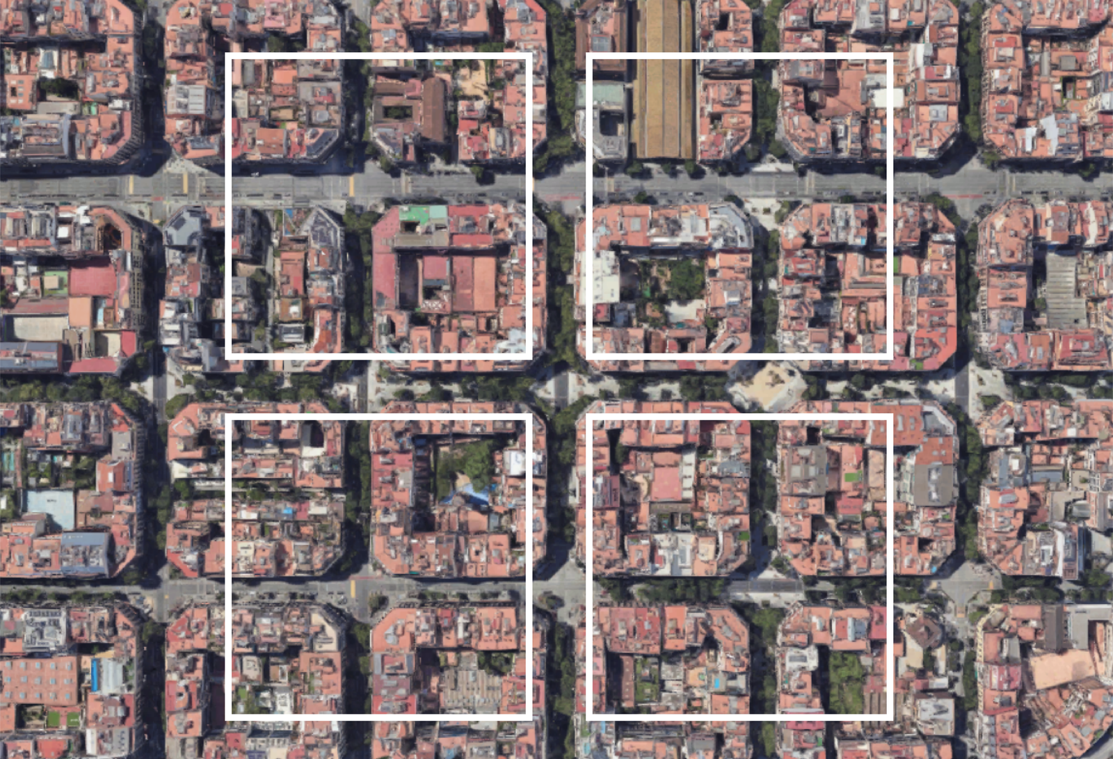
    Now for a comparison. Last week we spoke about Salt Lake City’s large city blocks (here and here). And so for fun, here’s what these blocks would look like on top of Barcelona:

    The most obvious takeaway is that Salt Lake City has larger city blocks than Barcelona, and that’s one reason why, objectively, Barcelona is more walkable and urban than SLC. But I think you could also view this graphic as a tremendous opportunity.

    Barcelona is in the midst of rethinking its urban fabric around something called “superblocks.” The idea here is to cluster blocks together and then concentrate transit and vehicular traffic along its edges, creating a more pedestrian-focused center. For example, in its largest form, a superblock might be a 3 x 3 grid, creating a grouping of 9 city blocks.

    But it doesn’t necessarily need to be a 3 x 3 grid. Other permutations are possible and the city plans to eventually introduce over 500 of them.

    The first superblock was implemented in 2017 and, not surprisingly, it improved air quality, increased quietness, and led to a significant decrease in car usage (-92%). Interestingly enough, it only led to a moderate increase in car traffic on surrounding streets (+3%). Traffic can be a funny thing.

    Creating superblocks out of smaller blocks is naturally easier than the opposite. You have an existing grid to work with. But there’s no reason that the opposite can’t also be done. And I think that’s one way to look at Salt Lake City’s street grid. It already has its superblocks. Now it’s just a question of creating all of its smaller blocks.

  • Big blocks and walkability

    Conventional planning wisdom tells us that smaller city blocks are generally preferable to larger city blocks. They make for more interesting walks (which can change our perception of distance) and they improve overall connectivity. This is why you’ll often hear planners advocate for things like “mid-block connections.” It is a way of creating the feeling of smaller blocks.

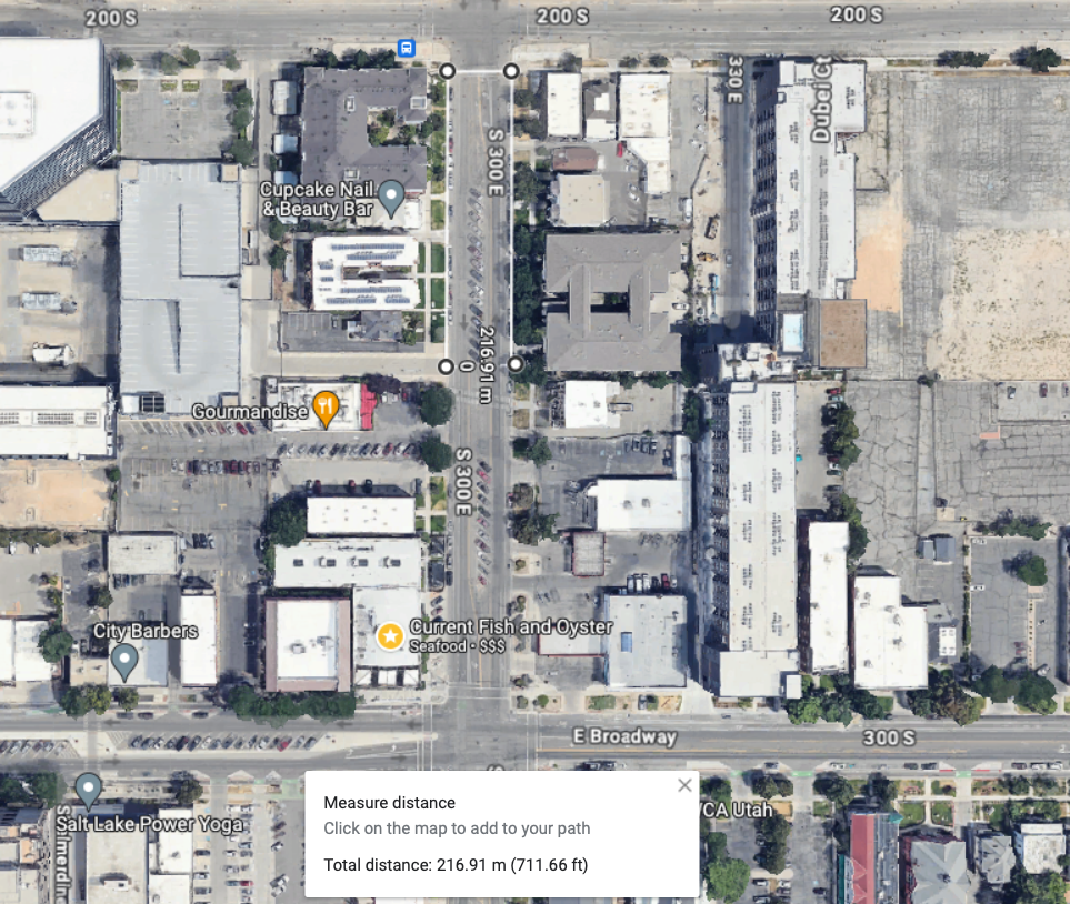
    Salt Lake City, as we have talked about, is the opposite of this. Its blocks measure 660 feet x 660 feet (call it 200m x 200m for those of us more accustomed to using the international standard for measuring things). This means that if you were to walk only 2 blocks (inclusive of 2 streets), your walk would be close to 500m, which is a commonly used walking/transit radius.

    Things get a bit tricker when you’re not walking in a straight line. For example, if you found yourself wanting to cross a street somewhere in the middle of a block — and you wanted to obey all traffic safety rules and not jaywalk — you would need to walk over 200m just to get to the opposite side. So basically a whole other block.

    There are also instances where even this street grid gets interrupted. This past weekend, I spent an evening walking to and from dinner on Main Street. And at one point, I got caught trying to cross the convention center (which occupies 3 blocks). I guess I could have tried to cut through, but I walked around, which added 2 additional blocks (~600m in total).

    Thankfully, SLC also has many instances of new mid-block streets/connections, road diets, internal laneways, and enhanced center medians, among many other things. I mean, here are some plans to turn Main Street into a pedestrian promenade. All of these interventions are an effort to soften the city’s underlying block structure, which we know tends to be indelible in cities.

  • What rules should we be breaking?

    Here is another great video from About Here talking about how breaking certain rules could make for better apartment buildings.

    The basis for the video is a design competition put on by Urbanarium, called Decoding Density, which asked participants to propose creative solutions for “six-story plus apartment forms in Metro Vancouver.”

    More specifically, the competition asked: How might Vancouver intensify its single-family neighborhoods with small-scale wood-frame apartments?

    The About Here video covers some of the common themes from the submissions and, not surprisingly, the first is single-stair buildings. Requiring only a single point of egress can really unlock small sites.

    Some of the other ideas are, perhaps, a bit more adventurous; but these are valuable exercises. Many rules are dumb. So it’s important that we continually question them and search for better ways.

  • Density lowers infrastructure costs

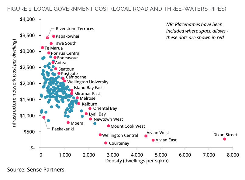
    This is an important chart from a recent study commissioned by Greater Wellington, New Zealand. The study looks at the cost benefits of urban intensification and the above chart shows the relationship been density and infrastructure costs. For this study, they specifically looked at the costs that local governments face in providing road, public bus transport, and “three-waters infrastructure.” I hadn’t heard this latter term before, but it refers to drinking water, wastewater, and stormwater.

    What they obviously found was that there are real economies to higher densities. More density lowers the per dwelling cost of delivering infrastructure. In the case of three-waters infrastructure, it doesn’t even really matter if you’re proximate to reservoirs or treatment plants. The bulk of the cost lies in the local connection pipes. So what matters most is how many dwellings you can service off of the main lines — even if these lines need to be upsized.

    The goal of this study is to enable more support for smart growth within the Wellington region:

    Regional councillor Thomas Nash says the report should give councils confidence to press on with plans that support compact mixed-use development in and around city centres and connected by high quality public transport. 

    “Regional growth needs to be smart growth. This report clearly shows that the best bang for our buck is to focus on upgrading existing water, public transport and local roading infrastructure so that we can build better quality, compact residential form, with improved amenities within our cities and towns,” Cr Nash says.

    Of course, this doesn’t just apply to Wellington. Every city should read the study.

  • In praise of leaving home

    As some of you know, I take a French class one evening every week. I have chosen to go in person, but apparently the majority of students enrolled at the school, don’t. They do it online, which is obviously easier for everyone. Call me old school, but I prefer being in a classroom, especially when trying to learn and perfect a language.

    I was reminded of this as I read through this recent article by Alain Bertaud. Alain is perhaps best known for his book, Order without Design: How Markets Shape Cities, and so it’s no surprise that he would write an article praising the randomness of cities. In it, he talks about how it is, of course, possible to never leave home. Meetings, food, entertainment, and exercise all happen online.

    This is convenient and all, but:

    Randomness makes city life exciting and productive, and how we design cities can multiply or reduce the chances of serendipitous encounters of people and ideas. Creativity and innovation, two of the most desirable traits of metropolitan environments, depend on unplanned meetings between people of different skills, tastes, and backgrounds.

    So here’s to leaving home, sometimes.

  • European office vacancy rates: La Défense vs. the Paris-CBD

    The first thing that stands out to me in this European office vacancy rate chart from Savills is the difference between Paris-La Défense (~15%) and Paris-CBD (2%).

    For those of you who maybe aren’t familiar, La Défense is the largest purpose-built business district in Europe. It houses upwards of 40 million square feet of office space and covers about 1,400 acres. It’s also more or less where Paris decided to allow and put tall buildings. Though, it is about 3 km west of the city limits.

    The Paris-CBD, on the other hand, is within the city limits and I’m assuming it refers to the quartier central des affaires (QCA). But regardless of the exact boundary definitions, what we are comparing here is a purpose-built business district to an older supply-constrained central one. And clearly there are, right now, meaningful differences in demand for the offices in these two areas.

    What’s also interesting is that there’s a meaningful difference in the rents. According to Reuters, office space in La Défense is on average about 50% cheaper than the QCA. This, to me, is a reminder that monofunctional urban areas tend to be less resilient over time. And that’s why La Défense is actively working to add additional uses, such as more residential.

    But it’s not just about uses. The area will also need to contend with the fact that it has a vastly different kind of built form; one that isn’t fine-grained and walkable like the QCA. This matters.