Daily insights for city builders, delivered every morning at 6 AM ET. I’m Brandon Donnelly — a Toronto-based real estate developer and founder of Globizen. I’ve been writing here since 2013.
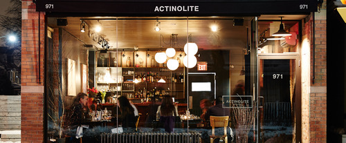
Back in 2011, blogTO ran an article calling Geary Avenue one of the ugliest streets in Toronto. And it’s certainly up there. It’s an industrial street with a mixture of different building types (lots of autoshops), giant power lines running along the south side of it, and a railway disconnecting it from the city to the south.
But as somebody who used to live around the corner from this street, I’ve had my eye on it for a number of years. Despite the fact that it was never very pretty, it always felt like an area with lots of potential. And sometimes it’s the areas that seem most unlikely to gentrify, that end up doing exactly that.
So whether you call it Dovercourt Park, Dovercourt Village, or some other name, I think it’s only a matter of time before Ossington cool moves north and the area in and around Dovercourt Road and Dupont Street becomes one of the hippest areas in the city. Get ready.
Full disclosure: I own a house very close to this neighborhood.
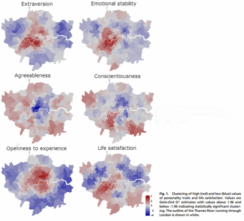
This morning Richard Florida published an interesting CityLab article that talks about how different personality types cluster within cities. The study he references was done by a team of psychologists that surveyed 56,000 people in the London metro area.
Here is a summary of what they found (darker red indicates higher concentration of each personality trait):
Probably the most interesting personality trait is the “openness to experience” one, as there appears to be a clear divide between people who live in the center of London and people who live in the suburbs.
Here’s how Florida describes it:
The most clustered personality trait the researchers found was “openness to experience” (bottom left map), which is concentrated in the center of London. Openness to experience, according to a wide body of psychological studies, is associated with creativity, innovation and entrepreneurship. This type is concentrated in higher density neighborhoods, with higher housing prices, more ethnic and religious diversity and higher crime rates. Meanwhile, the blue concentrations at the periphery indicate that there are fewer people open to experience in metro London’s suburbs.
It’s fascinating to think about the role of psychology in city building. It’s not something we often talk about, but it’s there.
I live downtown and I would definitely classify myself as extraverted and open to experiences. How would you classify yourself?
The headline immediately caught my attention because conventional economic wisdom would suggest that supply constraints – whether natural or artificially created – generally have a negative effect on housing affordability.
To be clear though, I support Ontario’s greenbelt. I think an urban growth boundary is the right thing to have if we want to build sustainable, walkable, and transit-oriented communities. But I’m also not blind to some of the potential (negative) externalities.
However, Keesmaat’s article got me wondering just how prevalent those externalities might be and to what extent our greenbelt is actually impacting housing affordability in Toronto. In her article she cites a recent report by the Pembina Institute that very clearly argues the following:
“There is no shortage of land throughout the GTA [Greater Toronto Area] to build single-family homes for decades to come, but this land is predominantly located far from the City of Toronto and other established centres of employment in the GTA.”
More specifically, the report found that of all the land available for development in the region (within our growth boundary), 81% of it is projected to still be unused by 2031. This got me thinking: it’s not that there isn’t land still available in the region; it’s that there isn’t land in the areas where demand is the greatest.
Put differently, young families aren’t clamoring for single family homes in High Park and Leslieville because the greenbelt has restricted their ability to find new housing. They’re doing so because they want to live in neighborhoods like High Park and Leslieville.
If you dive into the data, the report shows that in 2004 the average price of a detached home in Toronto was about $117,000 more than the rest of the Greater Toronto Area. As of 2013, that spread had grown to about $200,000. And indeed the data shows that it’s the core of the city where home prices seem to be appreciating the fastest.
So when it comes to housing affordability and supply, the greenbelt may actually be a red herring. Releasing it would not increase the supply of housing in areas where demand is already high, which is probably why this same report also found that – with or without an urban growth boundary – most Canadian cities are seeing similar increases in home prices.
So what should we be doing?
I think we should do two things: (1) focus on accommodating more growth in the areas that people already want to live in, and (2) figure out ways to transform the less desirable areas into more desirable ones. This second one will be the hardest, because it’s likely going to mean changing car dependent areas into transit-oriented ones, which is no easy task.
The good news though is that we are already doing these things. There’s more that I would like to see happen, but we’re headed in the right direction.
If your city has a greenbelt or you have experience with greenfield development in the Toronto region, I’d love to hear your thoughts in the comments. This is an area of development that I’ve never really been involved with.
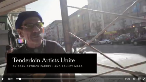
I’ve written about the Tenderloin neighborhood in San Francisco before. It’s an infamous neighborhood in the center of the city that has for decades resisted gentrification (which was the topic of my post).
But as the technology sector continues to urbanize, many fear that it’s only a matter of time before it does eventually gentrify. A new nickname has even emerged for the neighborhood: the Twitterloin.
However, a local nonprofit called the Wildflowers Institute is trying to ensure that gentrification doesn’t erase the cultural assets currently housed in the neighborhood. Through a project called “Hidden Gems”, the group is literally knocking on doors to find active artists within the community (many of whom live in single rooms) and then supporting them through fellowship programs and other investments.
What’s fascinating about their approach is that they are actively seeking out the informal activities taking place within the community – activities that would otherwise be hidden and then potentially lost. Once discovered, they then do a number of mapping exercises to keep track of this data.
As somebody who believes city building will become a lot more data driven in the future, I think this is a really interesting initiative. And as gentrification pressures continue to increase in San Francisco, I’m sure this information will help guide the discussions. You can’t account for something you don’t know exists.
One of the projects that I’m most excited about here in Toronto is the renovation and addition to One Spadina Crescent. The building sits in the middle of a roundabout along Spadina Avenue and occupies what is easily one of the most ceremonial positions in the city.
But for as long as I can remember, the building hasn’t been living up to its full potential. So much so that in the 1960s it was going to be demolished in order to make way for the proposed Spadina Expressway. That would have been an absolute tragedy. Thankfully, our friend Jane Jacobs stopped that one.
Today, exciting things are happening at One Spadina Crescent. The Daniels Faculty of Architecture, Landscape, and Design at the University of Toronto is in the midst of renovating and expanding the building, and will eventually relocate there from its current location on College Street.
When it’s all said and done, One Spadina Crescent will look something like this (via Daniels).
From the south:
From the west:
From the north:
What’s most exciting to me about this project are the following 3 things:
First, it’s an opportunity to connect One Spadina Crescent to the surrounding urban fabric. Today, it feels very much like an island in the middle of the street.
Second, it’s a wonderful example of the new layering on top of the old, which is something that I believe we should aspire to do in our cities. The University of Toronto has become quite good at doing that on campus.
Last week I wrote (yet another) post about Uber where I argued that leading cities will be the ones that engage with the sharing/rental economy (as opposed to try and outright ban it) and that Uber is going to continue to impact current beliefs around vehicle ownership.
As to be expected, some people agreed with me and some people didn’t:
But I also discovered following that post that there are groups, and hopefully cities, who are working to adapt to the changing realities brought about by disruptive innovation.
One of those groups is The National League of Cities – which I truthfully don’t know that much about. But they have created something called “The Sharing Economy Advisory Network.”
“Cities across the country have been struggling to respond to the rapid emergence of the Sharing Economy,” said Clarence Anthony, National League of Cities executive director. He continued, “Cities are looking for ways to update and improve their current regulatory framework to ensure that regulations like safety and health protect residents, while at the same time supporting the growth of new businesses. It is imperative for cities to learn how this industry operates and discover ways to engage in order to support these new modes of doing business and to create jobs.”
It sounds like the right kind of initiative and I wish them lots of success. I hope it’s effective and I hope that Toronto will look at how it too can properly manage these economic changes. This is going to take both the private and public sectors working together.
Yesterday my friend Sachin Monga published a really great article on Medium called, 2014: My Year in Review. It was broken down into a few sections that included everything from his favorite blog posts of the year to all of the images he posted on Instagram. He called it “a stream of personal observations, data, and highlights for the year.”
One section that really stood out for me though was Places & Transit. Using a mobile app called Moves, Sachin extracted an incredible data set for where he physically spent his time and how he got around in 2014. I can’t believe I haven’t heard of this app yet – it’s totally in my wheelhouse. But I’m clearly late to the party. Facebook bought them in the first half of last year.
The data set included how many hours he spent at home and at work. His top 3 most visited coffee shops. His top 5 most visited friends. How many nights he stayed in a hotel. His average daily commute time. And his total distance walked and cycled, among many other things. It was fascinating. I love data – especially when it was previously impossible or difficult to collect it.
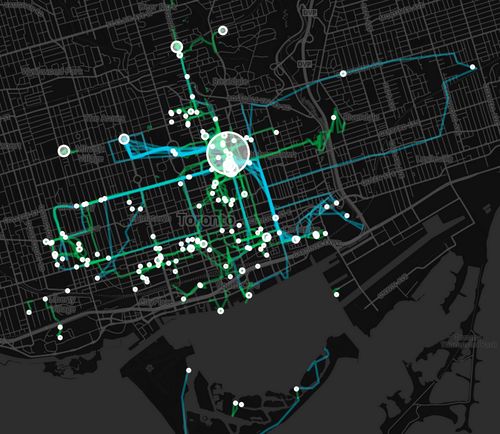
He was also able to translate his data into a set of beautiful maps, showing where he spent his time and how he got around. Here is his personal map for Toronto. The larger the circle, the more often he was there. Blue lines are cycling. And green lines are walking.
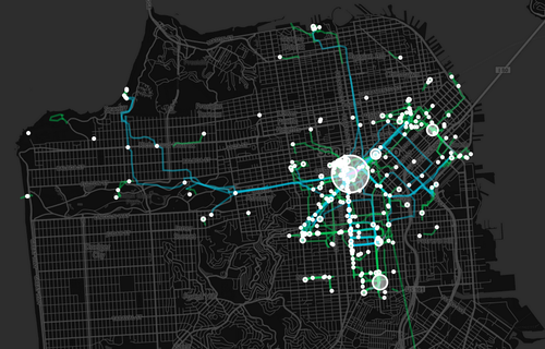
And here’s San Francisco (where he now lives):
After reading his post, I immediately downloaded Moves. And I can’t wait to see how my personal map of Toronto will look like in a few weeks and months. Once I have enough data points, I’ll be sure to share it with you all here.
In the interim, do you have any ideas for what this kind of data might be used for? I can certainly think of many. Let us know in the comment section below.
It felt like a frenetic year for me, and so I have to say that I’ve been really enjoying this holiday break. I needed the downtime. I needed the time to think and strategize. And I got all of that this holiday. (The only thing that would make this break even better would be some more snow on the mountains.)
I’m super excited for the new year and what’s ahead, but before getting into that, I thought it would be worthwhile to look back at what happened in 2014.
I was initially going to list out some of my thoughts, but then I figured that a better way would be to simply list out the most read Architect This City posts. That way it’s my (daily) thoughts, but curated according to what readers cared about most this past year.
A few years ago, I was touring a friend from the US around Toronto’s Financial District and the first thing he said to me was: “You have no retail.” And that’s certainly what it might look like at first glance.
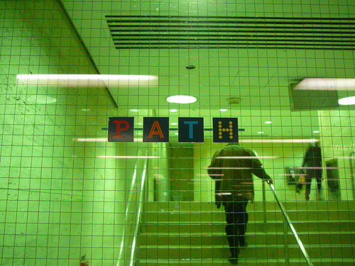
But there’s actually lots of retail. It’s just all underground in an over 30 kilometer long network of walkways called the PATH.
Initially conceived of as the antidote to Canadian winters, “underground cities” are a kind of uniquely Canadian form of urbanism. Toronto and Montreal have the largest ones in the world and they continue to grow. As new towers are built, new connections are added.
But the downside to all of this is that it pulls street life down underground. And it can conceal a lot of the urban vibrancy that is actually take place. So maybe we need to come up with design solutions to better connect these subterranean cities back to street level and also not forget about the street.
I’m thinking about this today because of a CBC documentary I watched this morning called Life Below Zero. It basically argues that – unlike other cold climate cities and countries – the vast majority of Canadians actually hate winter. And underground cities are our way of trying to ignore it.
Well, I don’t hate winter. In fact, I love it because it signals snowboarding season for me. But I may be in the minority. What’s your position on winter?
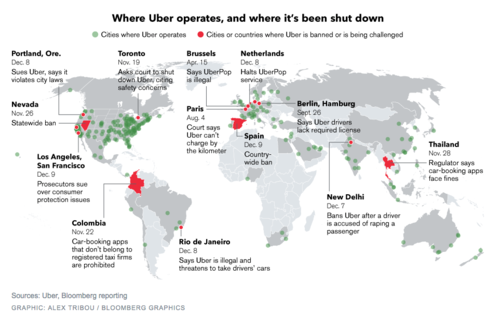
Earlier this month, Bloomberg published this map showing where Uber operates and where it’s been banned (or is being challenged). You can click on the map for a larger version.
Uber operates in about 250 cities across the world. But it’s being challenged in a lot of them, including Portland, San Francisco, Los Angeles, Toronto, Rio de Janeiro, Paris, Berlin, as well as others.
I don’t want to dismiss any of the safety concerns that have arisen lately, because those are very serious and they need to be addressed. Life safety is paramount. But I continue to believe that banning a service that many people clearly want to use isn’t the right solution.
On top of that, I think it could lull many of the local taxi communities into a false sense of security about the future. Uber is moving incredibly quickly. UberX launched in Toronto in September of this year. And UberPOOL – their new carpool service – is likely next.
With these releases, Uber is working towards a specific vision for the future: Their goal is to eliminate the need for private vehicle ownership. Should they be successful, this will not only impact taxis, but also car manufacturers and urban mobility in its entirety.
So as difficult as it might seem right now, I think urban leaders would be better served trying to figure out how to harness these innovations. Cities have been trying for decades to get people out of their cars. Uber wants to do the same.