Daily insights for city builders, delivered every morning at 6 AM ET. I’m Brandon Donnelly — a Toronto-based real estate developer and founder of Globizen. I’ve been writing here since 2013.

Tag: urbanism

  • What’s next for Walmart?

    Today I was surprised to learn from Charlie Gardner’s blog that groceries now represent 56% of Walmart’s sales. This is a huge number that I frankly wouldn’t have expected. 

    Groceries have relatively low online penetration, which makes them great for brick-and-mortar retailers. I’ve written about this topic before in the context of big box stores and online shopping. But I clearly didn’t realize that it had become such a big segment for Walmart. 

    What’s also noteworthy about grocery shopping though, is that customers appear to be less likely to travel far distances for it, even for lower prices. This means that the radial impact of Walmart the supermarket is less significant and far tighter (~2 miles) than Walmart the discount store. Click here for that study.

    This is important because a big catchment area has been central to the Walmart model. They consume cheap land on the outskirts of cities and then offload the transportation costs (indirect costs) to consumers in exchange for everyday low prices (direct costs). Studies show that we, consumers, typically undervalue indirect costs.

    Charlie argues in his post that this does not mean that we should write off big box retailing. And I would agree. The Walmart Express concept may have failed, but they are clearly looking for ways to rethink their model. Urban stores will need to form part of that.

  • Ziggurats and gondolas

    Yesterday was an exciting day for Toronto city building announcements. 

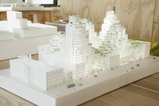
    Firstly, Alex Bozikovic of the Globe and Mail published an exclusive preview of architect Bjarke Ingel’s plan for King Street West. Here’s a photo of the architectural model (it’s by Landon Speers):

    My favorite quote from the article is this one from Bjarke:

    “It would be sad if the most diverse city in the world had the most homogenous real estate.”

    It’s true.

    For those of you who emailed me about the details of his talk next week (there were a lot of you!), I believe I emailed you all back. But in case I missed some of you, you can click here for the event details. I should have included it in my original post about BIG, but I thought the event was already oversubscribed.

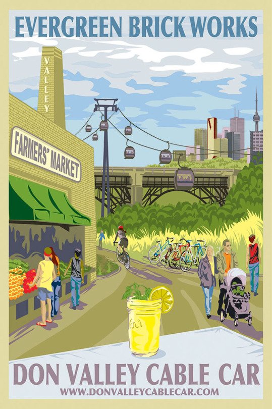
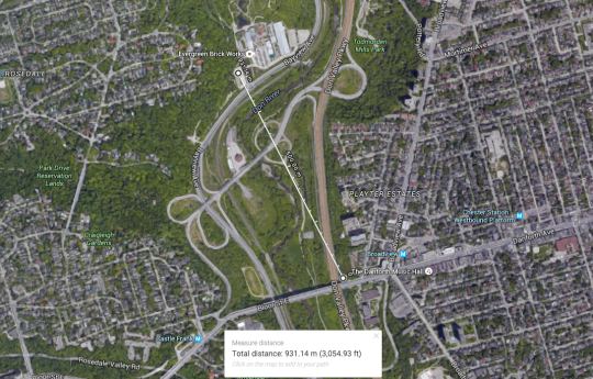
    Secondly, a private company called Bullwheel International Cable Car Corp. has just proposed to build a $20 to $25 million gondola running from Danforth Avenue (near Broadview subway station) to the Evergreen Brickworks. The total length would be almost 1 km and it, allegedly, wouldn’t require any public money. Here is their website.

    The timing of this proposal feels a bit serendipitous to me. When I was in Park City, Utah a few weeks ago, snowboarding right into the town and then taking their “town lifts” back up to traverse the mountain, I remember thinking to myself: what a wonderful form of transportation this is.

    Of course, Park City has giant mountains and Toronto, unfortunately, does not. But we do have spectacular ravines and a spectacular institution known as the Evergreen Brickworks.

    But one of the challenges with our ravines is that they can be a bit hidden – particularly for visitors to the city. Part of this is because we are trying to figure out the right balance between natural preservation and active use. But that’s one of the things that makes this proposal so intriguing. It’s a way to celebrate our ravines and natural landscape, without physically encroaching it.

    Here’s a map of the proposed gondola path:

    What do you think about these announcements?

  • A look at net migration by age group in Vancouver

    I’ve written quite a few posts about family formation and, more specifically, about where Millennials will move once they start having kids

    Many seem to believe that – despite the current Millennial love affair with urban centers – much of this cohort is destined to repeat the pattern of the previous generation. Meaning, once the kids come along, they’re headed to the suburbs in search of bigger and more affordable housing.

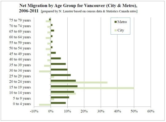
    If you look at the data, there’s a lot to support this prediction. Below is an interesting chart from Nathanael Lauster (Professor in Sociology at the University of British Columbia) that looks at net migration by age group for the City of Vancouver and the metro area.

    image

    What this chart shows is a flood of people in their late teens and early 20s migrating into the city (many of which are likely students), but then a fairly dramatic net loss of people leaving the city as they enter their 30s. The metro area, however, continues to grow – almost certainly because of people looking for more suitable family housing.

    But this data is from 2006-2011. We don’t yet have the 2016 census data. And I suspect that we will start to see an increase in the number of people opting to remain in the city across many different urban centers. 

    There are some very real economic pressures that successful cities today have to contend with. But I believe that the desire to remain in the city is there for a lot of young people.

  • Mr. Robinson — Architect as Developer

    I first learned about the work of Jonathan Segal back when I was in architecture school. And he was somebody I immediately admired. 

    At the time, I was struggling to figure out where I wanted to position myself between architecture and real estate development, and he was somebody who had seemingly figured it all out: he simply merged the two.

    For those of you who are unfamiliar with Jonathan Segal, he has made a name for himself by being a pioneer of the “Architect as Developer” business model. That is, he acts as both the architect and the developer/client.

    This business model isn’t going to suit everyone, but I suspect that we’ll see more of it in the future.

    Of course, it doesn’t just have to be an architect acting as a developer. It could also be an architect and a developer joining forces or some other permutation. Whatever the case may be, design and innovation are central to business today and that’s why I think this model will only become more relevant.

    Below is a short 3 ½ minute video about Segal’s latest project, called Mr. Robinson. It is located in San Diego. If you can’t see the video below, click here.

    [vimeo 155403927 w=500 h=211]

    If you’d like to see the typical floor plans or rent one of the apartments (they start at $2,400/month), click here.

    Now I’d be curious to hear your thoughts. Do you like the project?

  • Toronto’s rapid transit network by 2031

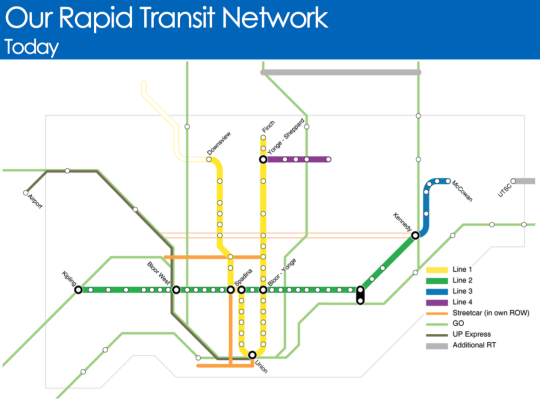
    Starting today and running until the end of March, the City of Toronto, the Toronto Transit Commission, and Metrolinx will be hosting several public meetings as they work towards planning out this city and region’s rapid transit network.

    Below are a few of the key maps from their presentation.

    Here is what Toronto’s rapid transit network looks like today (the hollow lines represent projects in construction):

    image

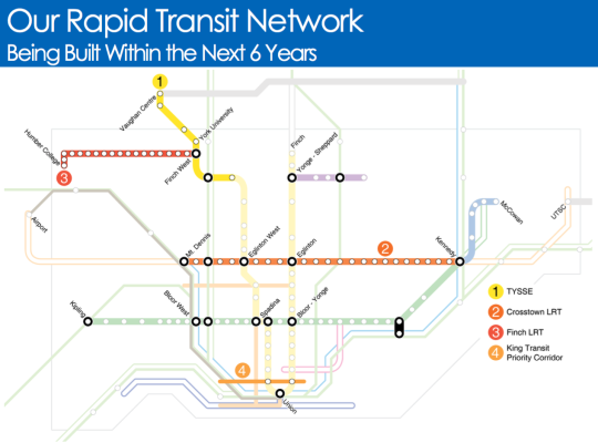
    Here is what will be built within the next 6 years:

    image

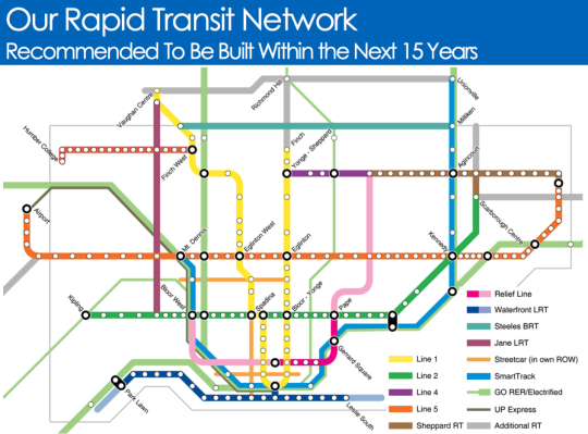
    And here is what they are recommending should be built within the next 15 years:

    image

    It’s hard not to get excited when you see maps like this. Of course, it’s a lot easier to draw lines on a map then it is to fund and execute on projects like this.

    But I think it all starts with us acknowledging that these initiatives are critical to both our economic competitiveness as a city region and our quality of life as citizens of it. Because if this is something we really want, then we can absolutely make it happen.

    Click here if you’d like to see the full presentation and also the public meeting dates/times.

  • Out of sight, out of mind

    Henry Grabar has an interesting piece in the March 2016 issue of The Atlantic talking about Paris’s ambitious metro expansion. By 2030, and after $25 billion of investment, the Paris system will gain four new lines, 68 stations, and more than 120 miles (192 kilometers) of track. 

    To put this into perspective, this additional track length is roughly equal to Toronto’s entire subway and streetcar network, including all under construction and approved lines.

    But the real focus of Grabar’s article was on how this transit investment will really stitch Paris back together:

    “Three of the new lines will run north and east of Paris, through Seine-Saint-Denis, the poorest of the 96 departments in France. Among French cities with at least 50,000 people, six of the seven with the highest percentage of foreign-born residents are in Seine-Saint-Denis. Residents of Clichy-sous-Bois, where the riots that swept the region in 2005 began, will for the first time find central Paris within a 45-minute train ride. The town of Saint-Denis, the site of the standoff between police and the terrorists who struck Paris in November, will be home to the project’s largest train station. Designed by the Japanese architect Kengo Kuma, the junction is expected to handle 250,000 passengers a day.”

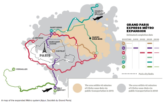
    Below is a map (from the same article) showing the location of Clichy-sous-Bois to the east of Paris and the area reachable within 45 minutes from this suburb, both today and in 2030 when the new metro lines open.

    Having traveled to Paris in 2006, shortly after the riots took place, I remember some Parisians telling me that this was not a Paris problem. They told me that this was a problem of the banlieues, but not of Paris. Seeing how separate Clichy-sous-Bois is today, that is probably how it felt to some or most. But based on the above, the Paris region is about to be stitched together.

    What I love about Grabar’s article is this idea that transit and connectivity represent a kind of citizenship for urban residents. And that even today, in our hyper connected world, physical access matters a great deal. Because without it, you might be out of sight, out of mind.

    On that note, here is how the article ends:

    Benoît Quessard, an urban planner for the local government, told me that he sees the expansion as not merely “an economic wager but also a social one.” In this sense, it will test an old Parisian belief about the Métro conferring, beyond convenience, a kind of citizenship on its riders. In 1904, four years after the first line opened, the writer Jules Romains predicted that the system would be a “living, fluid cement that will succeed in holding men together.”

  • My approach to blogging

    In yesterday’s post about the city as an egg, I received a comment basically saying that I use this blog to carefully curate my own image and that I would never argue against “dumb Toronto planning” because, after all, I’m a developer. I am going to do what breads my own butter.

    I welcome intelligent debate on this blog. That’s why it is open to anyone who would like to comment. But since I’ve received similar comments in the past, I thought I would use the opportunity to talk broadly about my approach to blogging.

    Firstly, there will always be some level of curation involved. That’s inevitable. We see it all over social media. But I’m a big believer in transparency and I try to do exactly that on this blog. I am keen to push the boundaries in this regard.

    At the same time, part of what makes blogs unique is that they’re often personal. That is the origin of blogging. Some of my favorite blogs to read are the ones that have figured out how to combine a particular niche topic with personal stories. And since ATC is ultimately my personal blog, I am going to continue taking that exact same approach.

    Secondly, I only write about things that I’m passionate about. I get asked all the time to write about and promote specific projects, causes, and events. But almost all of them do not get written about it. Because if I don’t care about it, then I’m not going to write about. It’s as simple as that.

    Thirdly, I believe in positivity over negativity. I believe that optimists, not pessimists, change the world. President Obama won his first term with a message of hope, not despair. To me, that is a stronger motivator.

    I’ve been told before that I’m overly optimistic and that my youthful exuberance will one day wear off. Boy, I sure hope it doesn’t. Because would you rather have a beer with someone who is optimistic or someone who is pessimistic? I will always take the former.

    However, this is not to say that I want to be blind to the realities of the world. Last summer I disagreed with Toronto’s decision to rebuild the elevated Gardiner Expressway East along the waterfront, and I continue to disagree with that decision. 

    When I believe something is a mistake, I am happy to make it public and put it in writing on this blog. But as a developer, I suppose I have certain biases working against me. That’s just the way it is.

    In any event, this is my rough and ever-evolving approach to blogging. As usual, I welcome any and all comments.

  • The city as an egg

    This week I have been thinking and reading about monocentric and polycentric cities. In urban real estate economics, the monocentric city model has historically been an important economic model. Developed in the 1960s, it attempts to explain land use in cities with one core, or central business district (CBD).

    In its most simplest terms, the model states that as you move further away from that core, land prices will fall. But since retail and employment need to be at the center of large catchment areas, they will remain in the middle, while the residential will naturally spread out.

    When you begin to factor in transportation costs, there is an argument to be made for why inner cities neighborhoods were often poorer in North American cities (no car; higher transportation costs) and why the suburbs were often wealthier. In this latter case, the rich wanted to consume more home/real estate and their transportation costs weren’t as significant. They had cars and subsidized highways in which to drive them on.

    Of course, there are many ways in which you could argue against the above. Today, urban neighborhoods are some of the most desirable areas in many cities. 

    But perhaps the most obvious thing to question is the idea that cities only have one central business district. I mean, just look at all the employment nodes in Toronto. Yes, downtown Toronto is still the dominant zone, but could we really be considered monocentric?

    From what I remember, the model had mechanisms for dealing with polycentricity. But at the same time, so much has changed since the 1960s. The central business district with its big department store was only just getting introduced to the likes of fully enclosed, climate-controlled suburban malls. And of course today, we are now living in a world of Amazon Prime and independent workers.

    So what does this mean for cities?

    Well, as I was reading up on this topic I stumbled upon this diagram by architect Cedric Price (1934-2003):
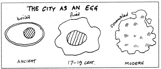
    I wish I knew exactly when this diagram was created, but I wasn’t able to find that online. In any event, the diagram uses different kinds of eggs – boiled, fried, and then scrambled – to explain the urban morphology of cities over time.

    In the ancient world, cities had a clearly defined core and a clearly defined perimeter – often a wall for defence (boiled egg). In the 17-19th centuries, cities started to expand outwards through the advent of technologies like rail. This gave them a more irregular shape (fried egg). And then finally, Cedric argues that the modern city had, or would, become all mixed together like scrambled eggs.

    I wouldn’t say that our cities have become completely scrambled. But I would agree that we are moving away from the simple fried egg of a city (or monocentric city model). So I guess the big question is really: How scrambled do you think we’ll get?

  • Urban, suburban, and rural home prices in the U.S.

    Zillow.com recently published some research where they looked at U.S. home prices broken down according to location: urban, suburban, and rural.

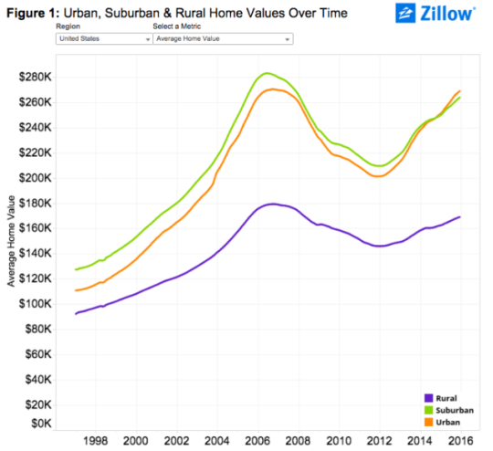
    Here’s what they found:

    image

    As you can see, urban homes across the U.S. largely trailed their suburban counterparts in terms of absolute value up until the end of 2014. At that point, urban homes then surpassed suburban homes for the first time in the last two decades. (I wonder if this is a first or there was another crossover point before the late 1990s.)

    But if you dig a little deeper and look at both the rate of appreciation and prices per square foot (as opposed to just absolute value), urban home prices appear even stronger. 

    Here’s a snippet from Zillow’s post:

    “Over the past five years (2010-2015), average urban home values have grown 28.4 percent, compared to 21.1 percent for suburban home values. In the past year alone, U.S. urban home values grew 7.5 percent, compared to 5.9 percent for suburban homes.

    On a per-square-foot-basis, homes in urban areas nationwide used to be worth roughly the same as suburban homes, before a gap started emerging in the late 1990s which has become progressively wider over the past roughly two decades. Currently the gap stands at 24.5 percent, with suburban homes valued at $156 per-square-foot and average U.S. urban homes worth $198 per-square-foot.”

    And here is that same chart showing per square foot prices:

    Everyone who reads this blog knows that there is a growing interest in urban centers. But if you look at the above charts for specific cities, there are still many cases where urban home prices are well below suburban ones. 

    To me, that serves as a reminder of the spikiness of this urban transformation, but also that it is likely still in its infancy. As recent as 20 years ago, Toronto largely didn’t believe that people would want to live downtown in modern apartments. Today we take that for granted.

    So even with all of the gushing about urban centers, I still think we are only just getting started when it comes to creating the great urban neighborhoods of the future.

  • AMYGDALA — An installation that converts social media sentiment into audiovisual art

    It’s becoming harder and harder to think of tech as a distinct silo. Tech is embedding itself into so many traditional industries that, one day, every company will probably be a software/technology company in some regards. 

    It’s for this reason that I often think and write about tech and its impacts on the built environment.

    An interesting example of this phenomenon is a recent art installation by fuse* called AMYGDALA. What it does is translate collective social media sentiment (specifically from Twitter) into an audiovisual art installation housed within an urban space.

    Here’s how they describe the project:

    “The news and thoughts of users spread across social networks in real time. And so an event with worldwide implications immediately involves millions of people sharing their own opinions and emotions: happiness, anger, sadness, disgust, amazement or fear. Thus, imagining Internet as a living organism, we might think that its emotional state may be given by the overall emotions shared by users at any given time. AMYGDALA listens to shared thoughts, interprets states of mind and translates the data gathered into an audiovisual installation capable of representing the collective emotional state of the net and its changes on the basis of events that take place around the world.”

    And here’s a video of it in action (click here if you can’t see it below):

    [vimeo 154049756 w=500 h=281]

    What I like about the project is how it takes something digital and ephemeral and then both aggregates and translates it into something physical within the urban environment. It’s a perfect visual representation of how technology and networks are – for better or for worse – seeping into our daily lives.