
Daily insights for city builders, delivered every morning at 6 AM ET. I’m Brandon Donnelly — a Toronto-based real estate developer and founder of Globizen. I’ve been writing here since 2013.

Tag: urban planning

  • The future of Vancouver’s West End

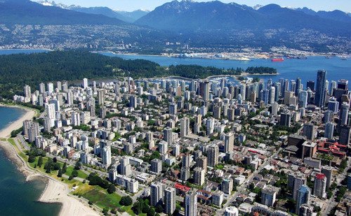
    Spacing Vancouver recently published an interesting look at Vancouver’s West End neighborhood. And it led me into a deep dive of the neighborhood’s recently adopted Community Plan (November 2013). So today I’d like to talk a bit about the neighborhood and also their plans for managing growth over the next 30 years.

    Officially established in 1969, the West End spent the next 3 decades as the most densely populated area of Vancouver. But starting in the 2000s with the development of high-rise condo towers in neighbouring areas such as Downtown South to the southeast and Triangle West and Coal Harbour to the northeast, the West End lost this position. Today it’s the 4th most densely populated neighborhood in the city.

    The bulk of the housing (77%) is in the form of apartments with 5 or more storeys. And 81% of residents are renters. This is well above the city average of 52% and is likely a reflection of the neighborhood’s younger demographic (25-29 years old is the largest segment) and its position as a landing ground for new Vancouverites.

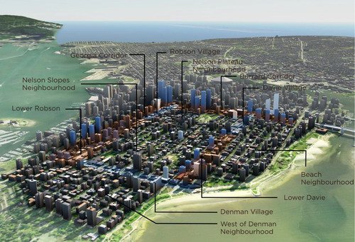
    But as a large central area with exceptional access to natural amenities, I would imagine that development pressures are and will continue to be significant. To plan for this growth, the city wants to intensify the central areas of the neighborhood with low-rise and mid-rise form and the periphery with high-rise towers. And already this is happening with developments such as the 62-storey Shangri-La Hotel.

    Here’s an image depicting their 30 year vision:
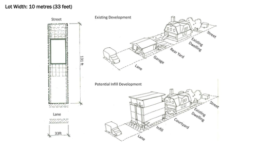
    But what stands out for me in the Plan is Vancouver’s continued commitment to laneway intensification. The Plan refers to it as “Laneway 2.0” and they specifically mention the opportunity to redevelop the West End’s wide laneways with “ground oriented infill housing.” Below is an example of how this could be done on a small residential lot, but the Plan also includes images for how the same might be accomplished on underutilized apartment building sites.
    Laneway housing is a topic I’ve written about extensively on ATC. Toronto is absolutely behind on this. And as I’ve argued before, we need to be looking at urban intensification across all scales, from low-rise to high-rise, if we want to create inclusive and vibrant cities. With the West End Community Plan, Vancouver seems to be doing just that.

  • The why of ATC

    The journey of Architect This City has been an organic one. When I first started blogging regularly in September 2013, I had no plan in mind other than that I wanted to write about cities. I had just come off working full-time on my startup, Dirt, where I had gotten into the habit of writing and I enjoyed it immensely. So I wanted to continue.

    Cities seemed like the perfect umbrella to capture all of my passions: architecture, design, planning, real estate, and even technology. And so I rebranded brandondonnelly.com—which I had already been using as a microblog—and slapped the title “Cities” on it. (That personal microblog has since become brandondonnelly.me.)

    Then, after a few months of blogging, I was having drinks with a good friend of mine and telling her about my new daily discipline. She immediately asked me what it was called and, when I replied by saying that I didn’t really have a name for it, she insisted that I create one immediately. Since she’s one of the brightest people I know, I gave it some serious thought. A few days later, Architect This City was born.

    I liked the idea of having a distinct brand, because then it meant it could grow beyond just a personal blog. It could become a real community of people passionate and committed to building better cities. And that ultimately became the goal as I got deeper and deeper into writing.

    Since that time last year, I’ve had friends guest blog on ATC. It has gone on to become syndicated on Mobility Lab and Urban Times. And it has been featured by the Guardian in the UK has one of the big city blogs in the world. But even more exciting are the moments when somebody tells me, either face-to-face or through a quick message, that they’re really enjoying ATC and that they read it daily. That’s what keeps me going.

    Lately though, I’ve been thinking about what’s next. What’s the purpose of ATC? What’s the why? I thought about writing a manifesto of sorts, but that just seemed unnecessarily onerous. So I sat down, primarily on the subway, with Evernote, and I wrote a purpose statement for ATC:

    To promote the building of beautiful and environmentally sustainable cities that offer strong economic opportunities and a high quality of life.

    That’s really what I believe cities should do. They should be enjoyable and beautiful places to live life and they should empower people to get richer. At the same time, we need to be aware that as more and more of the world’s 7 billion people move into cities, the need for environmentally sustainable solutions is only going to increase.

    So those are the kinds of discussions I hope we can have on ATC. Regular scheduled programming will continue as usual, but hopefully now the why is clearer. If you have any feedback on the above statement, I would love to hear from you in the comment section below.

  • Is there an urban planning pendulum?

    Take a look at this tweet I came across yesterday:

    image

    A different way of thinking, a century apart. pic.twitter.com/GoxUQs0bB4

    — Darren Proulx (@dnproulx)

    May 5, 2014

    //platform.twitter.com/widgets.js

    On the left is a picture of some crowded and dense city at, I presume, the turn of the 20th century. And on the right is a picture, today, of your generic suburban city with lots of cars, a broad street and auto-oriented signage everywhere.

    As the captions say, the city on the left is what modernist architects like Le Corbusier and powerful city builders like Robert Moses were trying to fix. What we ended up with, as a result of these efforts, is the city on the right. Now, today, we–architects, planners and urbanists–are all trying to correct what we see as a huge misstep in the way we designed and built cities.

    But is it really an anomalous misstep or is it simply a preferential pendulum that swings back and forth from generation to generation? One generation thinks cities are dirty and evil and that they need to be evacuated. And then the next generation loves them and wants to move back into them, which is what’s happening today.

    Dogma–particularly when it comes to cities–takes a long time to percolate through the system. Le Corbusier was espousing his city building ideals of “towers in parks” in the 1920s. That’s when he proposed to demolish 2 square miles of Paris (Plan Voisin) and turn it into what most people today would think looks like a New York public housing project.

    But for these new ideas to take hold, young architects, planners and builders first need to become indoctrinated in school or wherever they’re learning the ropes. Then, they need to get out and start practicing and mature to a point where they’re starting to influence and control substantial city building decisions. That’s why, I think, Le Corbusier’s ideas of the 20s really only became widely accepted as planning principles in the post-war years.

    Because of this though, I sometimes wonder if I too am just following the natural cycle of changing tastes. When I went to architecture school, we were taught that public transit is more efficient than private cars, density is good for the environment and for economic development, and that Le Corbusier was generally a crappy city builder. And if you’re a regular reader of this blog, you’ll know that that is generally the view I take here.

    But when I ask myself this question, I think of a few things. First, if you look at the urbanization of ancient cities, they were always organized around strong public spaces. The desire for human beings to be able to walk around, conduct business and socialize with each other is not a new phenomenon. And our post-war planning ideals put a strain on that.

    Second, take a look at the world and what’s happening. The majority of people now live in cities and we’re continuing to urbanize at a frenetic pace. Shenzhen in China went from a population of just over 300,000 people in 1979 to over 10.5 million people today. That is the pace of urbanization that city builders need to deal with. It’s unprecedented.

    And to even begin to make that manageable, I don’t think we can continue to build cities like the ones on the right side of the picture, above. It’s unsustainable both environmentally and from a mere space planning standpoint. There simply isn’t enough room.

    So call me a product of the times, but I just don’t see our current planning goals as one side of a swinging pendulum. I see them as a return to what cities have always been about: a place for people to interact, socialize and generate wealth.

  • The Human Scale

    Earlier today I stumbled upon a documentary called “The Human Scale.”  I haven’t watched it yet, but I’m planning to rent it from iTunes later this weekend. Here’s the trailer. Click here if you can’t see it below.

    [youtube https://www.youtube.com/watch?v=5CyLNS_ljHw]

    One of the things that’s so fascinating about studying cities right now, is that it feels as if we’re at a major turning point with respect to how we think about them. We’re coming off a long period (decades) of infatuation with the car, where planners and engineers predominately cared about one thing and one thing only: efficiently moving cars in and around cities.

    But having now fully built out cities around the car, we’ve come to realize two important things. First, that it’s virtually impossible to keep up with the demands of the car. No matter how many highways and roads you build, there always seems to be gridlock. And second, by focusing so closely on the car, we’ve built cities that aren’t great places for people.

    If you take a look at this short clip from The Human Scale (featuring Siena, Italy), I think you’ll immediately see how differently we used to build our cities and how disruptive the car has been to them. 

  • Are the suburbs really cheaper?

    image

    Smart Growth America released a report this month called Measuring Sprawl 2014. It’s an update to a report they did back in 2002 and it’s worth a read if you’re into urban planning. You can download it here

    The report looks at 221 metro areas in the US and develops a “sprawl index ranking.” The higher the number, the more compact the metro area. Not surprisingly, New York tops the list with San Francisco coming in second. But more interesting are the correlations they discovered. As you go up their sprawl index ranking (that is, as the cities become more compact), they found the following:

    • People have greater economic opportunity in compact and connected metro areas.
    • People spend less of their household income on the combined cost of housing and transportation in these areas.
    • People have a greater number of transportation options available to them.
    • And people in compact, connected metro areas tend to be safer, healthier and live longer than their peers in more sprawling metro areas.

    If you’re a follower of smart growth, then some of these will sound familiar. But they’re worth repeating and I’d like to focus on the second one for a minute (not to undermine the importance of living longer). Conventional wisdom dictates that as you sprawl out from the center of a city, the cost of housing drops. And indeed, that’s what they found. There’s a correlation between density and housing costs, and more compact cities generally have more expensive housing.

    However, they also found that the percentage of income spent on transportation is much less in compact metros:

    Each 10 percent increase in an index score was associated with a 3.5 percent decrease in transportation costs relative to income. For instance, households in the San Francisco, CA area (index score: 194.3) spend an average of 12.4 percent of their income on transportation. Households in the Tampa, FL metro area (index score: 98.5) spend an average of 21.5 percent of their income on transportation.

    But here’s where it gets interesting: they found that transportation costs dropped faster than housing costs increased as metro areas became more compact. Meaning if you consider both housing costs and transportation costs in aggregate, it’s actually cheaper to live in more compact areas. From what I can tell, they’re also only considering direct transportation costs and not indirect costs such as the time people waste sitting in traffic. 

    Either way, it’s something to consider the next time you’re thinking about where to live and how much you should be willing to spend on housing. That cheaper suburban home may not be as cheap as it seems.

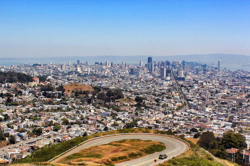
    Photo by Aythami Perez on 500px