Daily insights for city builders, delivered every morning at 6 AM ET. I’m Brandon Donnelly — a Toronto-based real estate developer and founder of Globizen. I’ve been writing here since 2013.

Tag: transportation

  • Red streetcar tracks

    A few months ago when I wrote about “Toronto’s great streets” I mentioned that Queens Quay West – while magnificent – has had its share of issues. Cyclists and pedestrians often find themselves battling for space. And drivers are consistently driving in the wrong places.

    Part of the problem, I think, is that the turning radii (among other things) are a bit atypical and unusual compared to the rest of the city. And so if you’re at all in mental autopilot, it can be fairly easy to make a wrong turn. You really have to be paying attention.

    Below is a screenshot from Google Street View showing the foot of Lower Spadina, looking east on Queens Quay West. If you’re making a left turn from the former onto the latter, you need to end up on the left (north) of the streetcar tracks (even though the tracks themselves might be directing you elsewhere).
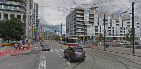
    There’s lots of signage telling you not to drive onto the tracks, but that hasn’t really been working. So the tracks were recently painted in bright red. You can see what that looks like here. Some people are still getting mixed up, but it’s certainly more noticeable.

    What I am wondering today is whether all of this signage and paint should be considered a symptom of poor design. In other words: Should good design require few instructions? Or, is this simply a normal part of iterative city building?

    What do you think?
  • Street-level intelligence and analytics

    I discovered a company yesterday called CARMERA, which just raised a $20 million Series B funding round. They call themselves a “real-time, street-level intelligence platform” and their flagship product, called Autonomous Map, provides HD maps and real-time navigation data to autonomous vehicles. That’s the way AVs work. They need maps like CARMERA’s to function. Here is an overview of what is supposedly the largest AV taxi service in the world. It is a partnership between CARMERA and Voyage.

    One of the interesting things about this product is that it is cleverly powered through another one of their products: a free fleet monitoring tool for commercial operators. So fleet managers use this service to keep track of their actual human drivers and, at the same time, CARMERA uses the vehicles to collect the data it needs for its Autonomous Map. They call it “pro-sourcing” the data (a play on crowdsourcing).

    It is perhaps a good example of “single user utility.” The product you’re making often has to be valuable to a single user before scale is reached. In this case, Autonomous Map would be a hard sell without a critical mass of pro-sourced data. It solves the perennial chicken-and-egg problem when creating new marketplaces.

    Finally, I think many of you will be interested to know that CARMERA has also announced a partnership with the New York City Department of Transportation. As part of this, the company will be handing over the data they have on pedestrian density analytics and real-time construction detection events. Part of their mission is to “automate cities” and better street analytics will certainly help to open up a new world of city building possibilities.

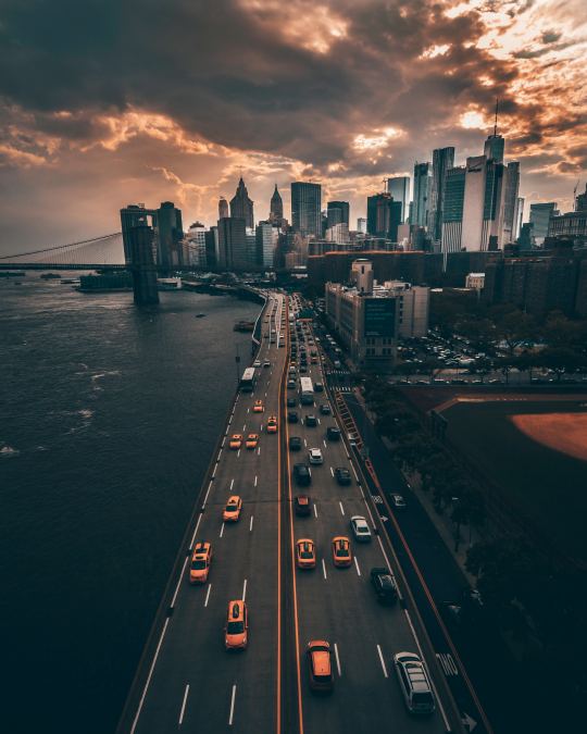
    Photo by Yeshi Kangrang on Unsplash

  • Lyft reveals plans for bikes and scooters

    On Monday, John Zimmer and Logan Green, the co-founders of Lyft, published this Medium post announcing their “approach to partnering with cities to introduce bike and scooter sharing” to their platform. 

    “Approach to partnering with cities” is undoubtedly a carefully chosen set of words given all the backlash going on right now around dockless scooters.

    Nevertheless, this is an exciting announcement. I could have used a scooter this afternoon to get to a meeting. And this is all part of their larger goal of transforming Lyft into a multi-modal platform – one that will also support conventional public transit.

    Here is an excerpt from the Medium post:

    Transit, bikes, small electric vehicles, and infrastructure such as safe pedestrian paths and bike lanes, all play a large role in decoupling people’s right to mobility from car ownership. We know we can’t accomplish this alone, and we’re committed to working with cities and residents to bring these elements together in the most cohesive way to maximize a reduction in vehicle miles traveled.

    The company has also set the goal that 50% of all trips on the Lyft platform will be shared rides by 2020. It is yet another example of the lines between public transit and ride sharing apps becoming blurrier. 

    Full post can be found, here.

  • Traffic signal inequality

    image

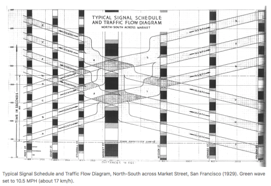
    David Levinson, who is based Sydney and authors the Transportist – a blog you should follow if you don’t – has a recent post up about signalling inequity and “how traffic signals distribute time to favour the car and delay the pedestrian.” In it he provides some background into traffic signal coordination (introduced in New York City in 1922), as well some some suggestions for how we could and should be prioritizing pedestrians.

    Here is an excerpt from the article:

    There is a reason that traffic engineers don’t automatically allocate pedestrian phases. Suppose the car only warrants a six second phase but a pedestrian requires 18 seconds to cross the street at a 1 meter/second walking speed. Giving an automatic pedestrian phase will delay cars, even if the pedestrian is not there. And there is no sin worse than delaying a car.  But it also guarantees a pedestrian who arrives just after the window to push the actuator passes will wait a full cycle.

    Sometimes pressing the walk button appears to do nothing. I suppose that’s why some cities call it the “placebo button.” And in other cases if you don’t press the walk button you’ll never get a walk sign. That’s usually a strong indicator that you are located in an environment not intended for pedestrians. David’s article also has me curious about the relationship between traffic signals/pedestrian phases and urban form. I bet you could tell a lot about the latter simply by understanding the former.

    Image: Transportist

  • Going dockless

    A couple of months ago I wrote about Bird, the electric scooter sharing company that is trying to solve the last-mile problem. They are expanding across the US and it is seemingly wildly popular.

    But its popularity is also leading some people to call them a public nuisance. Perhaps the biggest contributor to that is the fact that the system is dockless. That is, when you get to your destination you can park the Bird wherever you want.

    That’s obviously a great feature for users (who wants to look around for a docking station?), but it’s also causing a proliferation of “Bird litter” in the cities and neighborhoods where they are widely used. 

    I am sure this will eventually get resolved.

    The other thing about going dockless is that you now have a charging problem. Where and when do these scooters get charged and by whom? Bird solves this problem through decentralized contract workers called “Bird hunters.”

    You register to be one and then Bird pays you $5 to $20 for every scooter charged, depending on how difficult the Bird is to find. And as you can expect, these scooters are getting left all over the place.

    I thought this was a clever solution. And apparently it is popular with high school students looking to earn extra cash. Some are making several hundred dollars a day by spending their evenings picking up and dropping off Birds.

  • Last-mile electric scooters — will they work?

    I’ve been hearing a lot about Bird recently. Perhaps it has something to do with the $15 million Series A round they raised last month (February 2018) and the $100 million Series B round they announced earlier today.

    A “Bird” is small electric scooters that look like this and can be rented from your phone for short haul trips. They are currently available in Santa Monica, Venice, UCLA, Westwood, and San Diego, and they are intended to be ridden in existing bike lanes.

    What may be particularly interesting to this blog audience is the fact that Bird is calling itself a “last-mile electric vehicle sharing company.” The pitch: 40% of car trips (in the US?) are less than 2 miles long. Let’s replace those using electric scooters.

    One of the first things that came to my mind is that this feels more accessible than cycling. Cycling to work can be a commitment. You have to think about your attire and the sweat factor, among other things.

    Would you agree?

  • The longest outdoor escalator system in the world

    This morning I took the mid-level escalators down to Hong Kong station so that I could catch the express train to the airport. At over 800m, it is supposedly the longest outdoor covered escalator system in the world.

    If you’ve ever walked the streets of Hong Kong you’ll know that the ground plane can be inhospitable at times. There’s limited space, but no shortage of steep pitches. I can’t imagine having a physical disability and trying to navigate this city.

    So this system must have been a real innovation when it was constructed in the early 90′s. In total it moves up and down about 135m in elevation. That’s about the equivalent of a 45 storey tower. And I got down from the mid-levels and was on a train to the airport within 15 minutes.

    But because the streets here are so narrow it’s a unidirectional system with one line of escalators. They bring people down to the CBD during the morning rush, but then the direction flips and they bring people up the hill for the remainder of the day — until midnight I believe. Living near these escalators is considered a win.

    Hong Kong Island surely isn’t the easiest of environments in which to build and operate one of the world’s most important global cities. There’s relatively little developable flatland. But they more than made it work by being creative and by building up. Hong Kong is not just a tall city, but a truly vertical city.

    Too bad my efficient morning commute was followed by a cancelled United flight. Tomorrow is not going to be a fun day travel.

  • So the tech works. What’s next?

    Below is a keynote talk by Benedict Evans about what’s going on in tech today and what may happen in the next ten years. It covers: the growth of mobile; S-curves; Google / Apple / Facebook / Amazon (who knew Amazon had so many employees?); machine learning; autonomous vehicles/impact to cities; mixed reality; crypto-currencies; and so on.

    For those of you interested in crypto-currencies – and that appears to be everyone these days – it’s interesting to hear how Evans describes their current position at the beginning of the curve: “The tech works, but what’s the use case?” This is not to say the potential isn’t huge. It is. Automated trust. Distributed and programmable money. But the future is still unclear.

    If you can’t see the video below, click here.

    [youtube https://www.youtube.com/watch?v=cVYDkPidXrU&w=560&h=315]

  • Stockholm’s congestion charge reduced car traffic by 20%

    Stockholm has a congestion charge that is used to reduce traffic volumes in the center of the city. Toronto does not. We looked at it, actually fairly recently, but then we lost our nerve.

    Stockholm’s congestion charge was first implemented on a trial basis starting in January 2006. Trials and pilots have become a common way to actually create positive change. Otherwise the status quo bias may simply be too strong.

    When Stockholm started the trial back in 2006, public support was very low. Maybe 30%. But as soon as it was implemented, car trips dropped overnight by 20%. Once people saw the benefits, support grew – hitting around 70% by 2011.

    Here is a brief Street Films video with Stockholm’s Director of Transport, Jonas Eliasson, talking about their experience with congestion pricing. If you can’t see the video below, click here.

    [vimeo 244771087 w=640 h=360]