Daily insights for city builders, delivered every morning at 6 AM ET. I’m Brandon Donnelly — a Toronto-based real estate developer and founder of Globizen. I’ve been writing here since 2013.

Tag: transit

  • Fixing the MTA

    Fred Wilson wrote a great post on his blog today about New York City’s “transit mess.” 

    In it he talks about congestion pricing (which, as you all know, I support); the mess that is the Metropolitan Transportation Authority (MTA); and this 37-page report on how to improve the MTA.

    Here is an excerpt from his post that I liked, but that won’t be popular with everyone:

    That is an idea [congestion pricing] that has been proposed a number of times over the years, most notably by Mayor Bloomberg during his tenure. It is a good idea and long overdue. A dense urban environment should have excellent mass transit and incentives to use it and should have disincentives to drive cars. Taxing cars in Manhattan and using the revenues to maintain and improve our subways seems like an obvious thing to do.

    I would encourage you to give his post a read. The New York Times also reported on this topic (and the above recommendations) this week. They called it, 7 ways to fix the MTA (which needs a $60 billion overhaul).

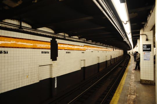
    Photo by Joren on Unsplash 

  • How road pricing impacts income groups

    The Pembina Institute has just published this report looking at the impact that road pricing could have on the various income groups across the Greater Toronto and Hamilton Area. One of the common arguments against road pricing is that it disproportionately impacts lower income folks.

    The study specifically looks at the proposal that Toronto put forward in 2016 to apply a flat congestion charge of $2 on the two highways leading into downtown. The proposal was ultimately rejected by the province, but I thought it was a step in the right direction. In my opinion, a dynamic road pricing model, similar to what is used in Singapore, would be preferable.

    The report concludes by arguing that road/mobility pricing is destined to become a tool in this region if we are serious about managing congestion. However, they also note that it must coincide with a strong and sustained investment in transit. And I would agree with that. That’s one of the reasons why you do this – to fund transit.

    To download a PDF of the report, click here.

  • One year anniversary of the King Street Transit Pilot

    I had dinner tonight on King Street and I was reminded that this week marks the one year anniversary of the King Street Transit Pilot here in Toronto.

    The pilot has certainly had its share of controversy, but the improvements to both transit reliability and ridership are clear. Average travel times (in each direction) have increased by as much as 7 minutes on the route.

    Here’s the latest data from July and August of this year. Steve Munro can also tell you everything you ever wanted to know about the King streetcar.

    As our city continues to grow, many are naturally concerned about the ability of our infrastructure to handle the additional demands. Where will all the cars go?

    But the reality is that we will never be able to accommodate everybody driving around in their own car. Which is why we have to rely on transit and solutions like the King Street Transit Pilot.

    What’s your opinion of the pilot now that it has been in place for a year? I almost forget what it was like before we had it.

  • Project Profile: New Central Library, Calgary

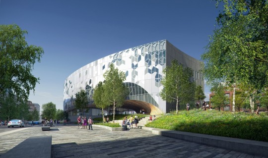
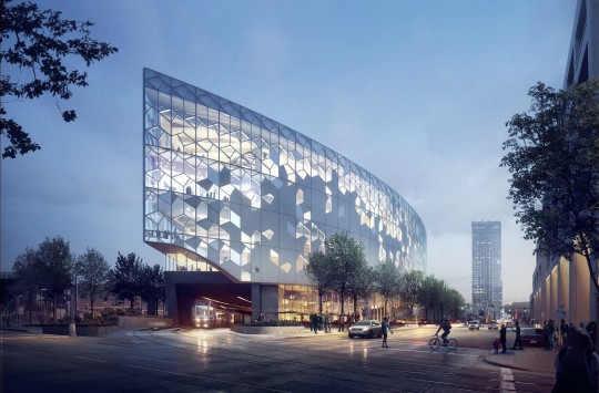
    The City of Calgary opened up its New Central Library this past week on November 1st, 2018, after a five-year construction process. 

    Designed by Snøhetta (design architect) with Dialog (architect of record) and Entuitive (structural engineer), the building was previously named one of “the 12 most anticipated buildings of 2018″ and one that will surely serve as a landmark for the city.

    One of the most interesting things about this project, for me, is how it both gives back and integrates with the broader urban fabric. 

    It is both a library and public plaza, and it sits atop the city’s busiest LRT line. About 40% of the site area is taken up by tracks (and probably setback), which means that the structural system of the building was forced into 12m (~40 foot) clear spans (done in concrete). It is the first time in the city’s history that an active LRT line has ever been encased and built over.

    It is a magnificent building and reason enough to visit Calgary, if you aren’t already there. I am hoping to get out there and photograph this project sometime soon.

    Images: Snøhetta and Entuitive 

  • Transit tech lab launches in NYC

    image

    Earlier this month, the Metropolitan Transportation Authority (MTA) and the Partnership for New York City launched a new vertical accelerator dedicated to public transit. The mission is to make the city a global leader in this space.

    Applications are open until November 30, 2018 and they are looking for early and growth stage companies that address one or both of the following challenges:

    1. How can we better predict subway incident impacts and serve customers?
    2. How can we make buses faster and more efficient?

    Selected companies will go through an 8-week accelerator and, at the end of it, the most promising companies will partner with the MTA on a 12-month pilot. So it is an opportunity to potentially test your product(s) on the largest transit authority in the US.

    If you’d like to apply, you can do that here.

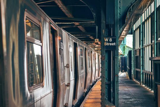
    Photo by Tim Gouw on Unsplash

  • Microsoft Canada moving to CIBC Square

    image

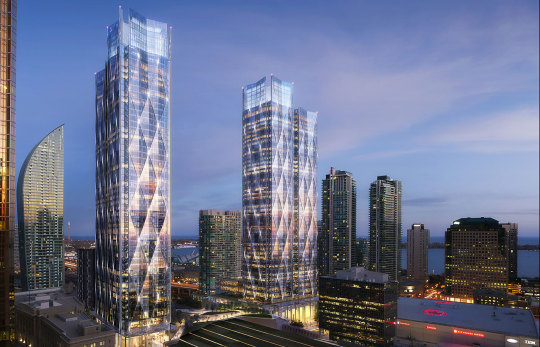
    Today, Microsoft announced that it will be moving its Canadian headquarters from Mississauga to the new CIBC Square development that is currently under construction in downtown Toronto (and rendered above). 

    According to RENX, Microsoft will occupy 132,000 square feet across 4 floors in the first tower. Occupancy is scheduled for September 2020.

    I love this project. The design architect is WilkinsonEyre. And there’s going to be an elevated one-acre park spanning the rail corridor between the project’s two towers.

    But it’s also noteworthy because it is an example of a major suburban tenant deciding to relocate to a transit-oriented urban environment. (I have a post on this somewhere.) 

    Image: WilkinsonEyre

  • Red streetcar tracks

    A few months ago when I wrote about “Toronto’s great streets” I mentioned that Queens Quay West – while magnificent – has had its share of issues. Cyclists and pedestrians often find themselves battling for space. And drivers are consistently driving in the wrong places.

    Part of the problem, I think, is that the turning radii (among other things) are a bit atypical and unusual compared to the rest of the city. And so if you’re at all in mental autopilot, it can be fairly easy to make a wrong turn. You really have to be paying attention.

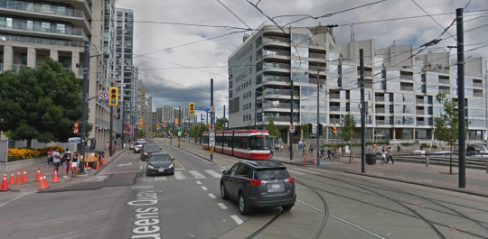
    Below is a screenshot from Google Street View showing the foot of Lower Spadina, looking east on Queens Quay West. If you’re making a left turn from the former onto the latter, you need to end up on the left (north) of the streetcar tracks (even though the tracks themselves might be directing you elsewhere).

    There’s lots of signage telling you not to drive onto the tracks, but that hasn’t really been working. So the tracks were recently painted in bright red. You can see what that looks like here. Some people are still getting mixed up, but it’s certainly more noticeable.

    What I am wondering today is whether all of this signage and paint should be considered a symptom of poor design. In other words: Should good design require few instructions? Or, is this simply a normal part of iterative city building?

    What do you think?

  • Downward pressure on parking supply

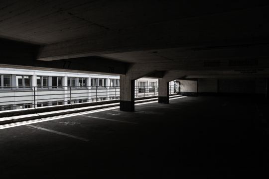
    There’s a significant amount of downward pressure on parking supply in most major cities. Part of this has to do with the push toward more sustainable forms of transport, which is, of course, a good thing. But it also has to do with rising construction costs, the fear of obsolescence in the wake of autonomous vehicles, and probably many other factors.

    Developers, ourselves included, have responded by being cautious about the amount of parking being provided and by considering alternative future uses for the parking that is being built. I think it is also obvious that we will continue to see more, rather than less, parking stackers and other more efficient parking solutions.

    So far the cost of parking in dense urban centers has continued to rise. A new parking spot in the core of Toronto priced at $100,000 would not surprise me. And Hong Kong recently set a record for what is allegedly the most expensive parking spot in the world: USD 765,000 or CAD 1 million.

    But what is going to happen going forward?

    Researchers at the Singapore – MIT Alliance for Research and Technology and MIT Senseable City Lab, along with Allianz, have recently tried to quantify what the impact of autonomous vehicles will mean on required parking, and on traffic, in Singapore. The study is called Unparking.

    Today, they estimate the total number of parking spots in Singapore to be around 1,370,000. This is based on minimum parking requirements from the Housing Development Board and on the idea that home-work commuting consumes two parking spots: one at home and one at the office.

    They model four different scenarios, but the last one is based on fully autonomous vehicles and on shared parking spaces. Holding current mobility demands and traffic volumes constant, the demand for parking in this scenario drops by 70%.

    It is possible to reduce the number of parking spaces even further to 85%, but this has a negative impact on traffic congestion in their model. Fewer parking spaces means the autonomous vehicles have to drive around more picking people up. 

    I also don’t know if there was any consideration given to induced demand as a result of the more affordable autonomous vehicles. Demand for transportation services is generally thought to be fairly elastic.

    Whatever the case may be, numbers are made to be questioned. And Singapore is a unique city-state. But ¼ the amount of parking does not seem that far fetched to me.

    Photo by Tobias Jussen on Unsplash

  • Preliminary design ideas for Toronto’s Quayside

    Last week Sidewalk Toronto held a roundtable discussion here in the city and released some preliminary design ideas and strategies for Quayside. (That’s why Dan Doctoroff was talking on BNN Bloomberg.) 

    I went through the full presentation this morning and below are a bunch of slides that I thought you all might find interesting.

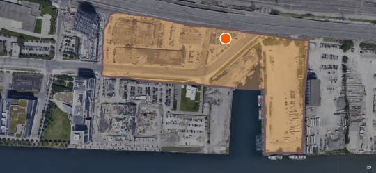
    Here is the extent of “Quayside” along the waterfront. The current land use permissions allow for about 3 million square feet of space and towers as tall as 50 storeys.

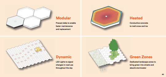
    Here is a paving system being explored for the area. It is modular. It may melt snow. And perhaps most interestingly, it would allow for dynamic changes in road use throughout the day. This sort of thing already happens to a lesser degree on streets like Jarvis. This technology could take that much further.

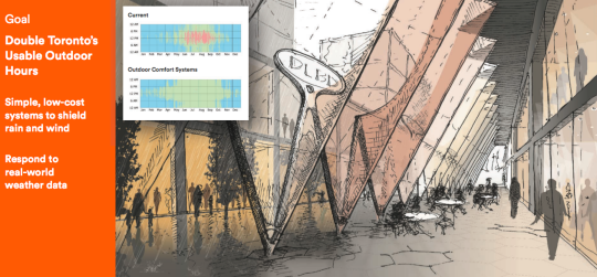
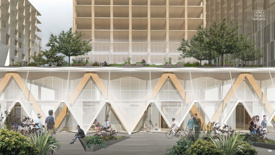
    One of their primary goals is to double Toronto’s usable outdoor hours. To do that, they are proposing simple weather shields (pictured below) and weather-responsive systems.

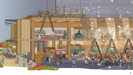
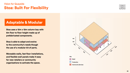
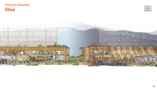
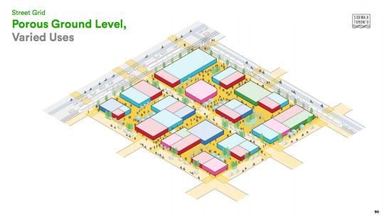
    They are spending a lot of time thinking about the ground floor of buildings, which they are calling Stoa. The idea is to create flexible and porous spaces that respond quickly to changing needs and that integrate more seamlessly with the surrounding public realm.

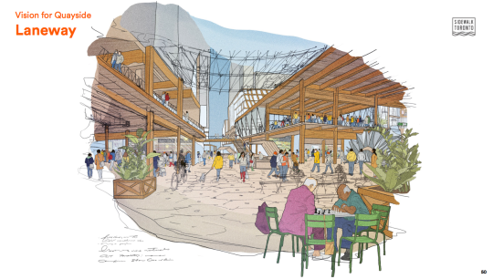
    There’s a lot on the potential hierarchy of the street network and how each will function for transit, conventional cars, AVs, cyclists, pedestrians, and so on. I was happy to see “laneways” as a core part of the pedestrian network. They are designed for walking speeds. Access would be restricted for things that move too quickly.

    This image ties in the street grid and Stoa.

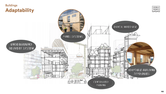
    Finally, the goal is to build the neighborhood entirely out of timber, and more specifically, Canadian timber. If they follow through on this, I think it would really push adoption of this material forward in the city.

    I would encourage you to check out the full package, which you can do here. I can’t wait for these projects to get underway along Toronto’s waterfront.

  • Toronto’s great streets

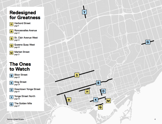
    Last week the Ryerson City Building Institute published a terrific report on Toronto’s Great Streets. It profiles five streets in the city that have been “redesigned for greatness.” They are:

    • Harbord Street (continuous bike lanes)
    • Roncesvalles Avenue (placemaking and people)
    • St. Clair Avenue West (dedicated streetcar lane)
    • Queens Quay West (public waterfront promenade)
    • Market Street (prioritized for people and patios)

    But what exactly makes a street a great one? The report describes it in this way: “They all play a key role in making the surrounding neighborhood a great place to live, work, and visit.”

    This relates closely to what the City of Toronto calls a “complete street”, which is an approach to accommodating multiple kinds of users, enhancing the local context, and determining which trade-offs to make.

    And there will always be trade-offs. I am fairly certain that all of these street redesigns were contentious at the time when they were proposed. Because at the end of the day they will never be all things to everyone.

    I remember the St. Clair West fight vividly because I moved to the neighborhood in 2009 and the dedicated streetcar lane didn’t fully open until 2010. From 2005 to 2017, streetcar ridership grew 23%. But drivers have remained grouchy.

    I now walk Market Street every single day and I agree that it’s one of the most beautiful and functional streets in the city. But the bollards are constantly getting beat up by drivers attempting to parallel park and the retail vacancy rate has not been 0% like is suggested in the report.

    Queens Quay West is also a magnificent street. It was a giant step forward in terms of the quality of the public realm in this region and I spend a lot of time there. But it’s of course not perfect. All of us have seen the reports of cars ending up in odd locations, including underground, along the waterfront.

    Riding your bike there can also feel like a challenging game of Frogger with all of the pedestrians that now obliviously meander back and forth across the cycling trail. I suggest riding with a good blow horn. The report rightly mentions the lack of delineation between these users.

    But cities are a living laboratory and none of these streets should now be considered static. We are fortunate to be in a position to critique levels of greatness. If anything, the map at the top of this post tells me that we need to create more greatness across the other areas of this city.