Daily insights for city builders, delivered every morning at 6 AM ET. I’m Brandon Donnelly — a Toronto-based real estate developer and founder of Globizen. I’ve been writing here since 2013.
This afternoon I rode Toronto’s new streetcar for the first time on my way home from Chinatown. I had been meaning to do it for weeks now, but this was my first opportunity.
The experience was infinitely better than what you get today on our current streetcars. I felt like I was in a new city. The proof-of-payment system makes onboarding much faster and the 4 loading doors means you just get on the train where there’s the most room – instead of getting on at the front and fighting your way to the back.
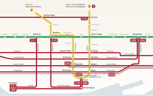
The other thing I liked is that they now have a map of our streetcar network within the train (see above image). Toronto never used to do this. For whatever reason, we didn’t like mixing subway lines with streetcar lines on the same map.
But why be so pedantic?
For one thing, our subway map looks pathetic without these additional streetcar lines on it. So for the sake of Torontonian morale, please fill it up with what you can.
But the other reason why I think it’s important to include them is that we shouldn’t be thinking about our cities just in terms of specific technologies (subway, streetcar, and so on). Our cities are now multi-modal. Which means we navigate them using many different means, from subways and streetcars to bikes and Uber cars. What people care about is getting from A to B in the most efficient and enjoyable way possible.
This may seem like a subtle distinction, but it’s an important one. And maybe, just maybe, these new maps will serve as an important reminder to us that there’s a lot of fixed rail in this city and that it could be far better optimized if we just tried a little harder.
Earlier this week I wrote a post about a new build home under construction at 37 Canerouth Drive in the west end of Toronto. As part of that post, I asked people what they thought the home would be valued at when it was completed. There were just under 10 responses (many thanks!) and I thought it was really fascinating to see the ranges.
A lot of you responded in the comment section of the post, but a bunch of the other estimates came in via Facebook, Twitter, and email. It isn’t a huge data set, but I’ve nonetheless consolidated the ones I could remember I received:
If you average these estimates, you come to a value of $3.3M. However, the clear outlier is the $8.5M. So let’s take that one out and see how the number changes. If you do that, you then get an average estimate of $2.5M. A pretty big swing.
Now, I don’t know offhand how accurate that number really is, but I’m fascinated by this idea of “the crowd” determining value. Particularly for markets such as housing where supply can be completely heterogeneous and there isn’t a lot of transaction volume to refer back to (compared to other types of markets).
Because my strong belief is that under the right circumstances and with enough data points, this number could end up being hugely accurate. And, it could also be more forward looking since it’s capturing current market sentiment as opposed to being based on historical transaction prices.
If you have any thoughts on this, I’d love to hear from you 🙂
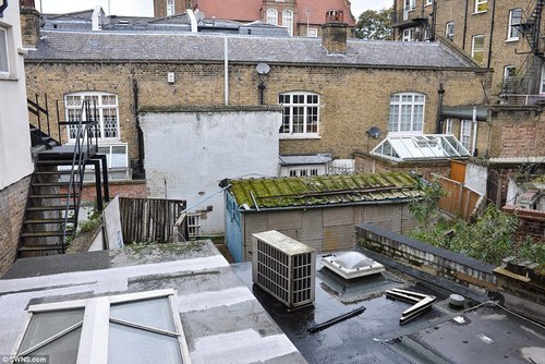
The garage shown above (with the pseudo green roof) is located in the Chelsea neighborhood of London. It measures about 11’ x 7’ and it – along with the site it sits on – is about to go up for auction.
It’s expected to go for more than £550,000 according to the DailyMail UK, which would make it the most expensive garage ever sold in the UK. The site area is 535 square foot – about the size of an average 1 bedroom condo in Toronto.
Below is an aerial view of the site. It basically looks to be residual land.
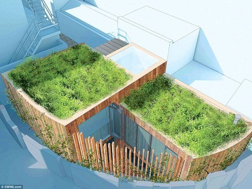
But as awkward as this site might appear, the expected value is being driven by the fact that planning permissions were granted to turn it into this:
It’s a 2 bedroom house that feels a lot like a laneway house. It certainly fits the description of “a house behind a house”, which is often how laneway housing gets described here in Toronto.
I wanted to share it because it supports my belief that, sooner or later, Toronto will come around to laneway housing. As property prices rise and affordability continues to erode, people will – quite justifiably – start looking in all sorts of new places for a decent urban home.
Many thanks to my friend Adrian for sending me the link.
CityLab published an article last week on multi-modal cities that caught my attention (because it used a picture of Toronto with about 3 or 4 streetcars stacked up along Queen Street). The premise of the article is that all of this car vs. transit debate is actually missing the bigger picture: our cities are multi-modal and we need to be planning for that.
That’s not to say that the shift away from cars isn’t a good thing. It is. But it’s not as simple as saying that, instead of driving, people should now only take transit. In today’s cities people walk, bike, take streetcars, take buses, take subways, take taxis, take private shuttles, use Uber, and, yes, they still drive.
From my own experience, this is absolutely how I get around Toronto today. I walk to the gym. I ride my bike whenever I’m going somewhere downtown. I take the subway to my office in midtown because it’s far and I would be too sweaty if I biked there. I use Uber and Hailo when I’m going out at night. And I drive when I need to go to the suburbs or leave the city.
But the key takeaway here is that we now have a much tougher challenge on our hands. When we were only optimizing for cars – however detrimental to our cities that was – we only had one mode to plan for. Now we have several. Some of which are public and some of which are private.
However we also have access to technologies that we didn’t have before. We are networked in ways that weren’t possible before and we’re at the dawn of many profound mobility changes, such as driverless cars. (Have you read about Tesla’s new Autopilot feature yet?)
So as I’ve said before, I really believe that we need to look at this, not as a war on the car, but as a war on inefficiency. The problem we are trying to solve relates to mobility: What’s the best way to move lots of people around dense urban regions? Stop focusing so much on the technologies and focus more on the people.
Earlier this week, I wrote about the Charlotte Apartments in Berlin and tried to back into some of the numbers for the project. I wanted to compare the economics behind a mid-rise project in Berlin to one in Toronto.
After I wrote that post I forwarded it to Michels Architecture – who are the architects behind the project. I thought they might be interested in reading about my (crappy) back of the napkin type of assessment and I was also hoping that they might be able to shed some additional light on the details.
Well, they responded and graciously offered to do exactly that. So today I thought I would write a follow-up post with some additional details. I obviously don’t have everything – because they weren’t the developer for the project – but I still think you’ll find the information I got interesting.
The building has a total of 3 parking spots and they’re all on the ground floor (you can see them in this post in the second photo towards the right). They were for the penthouse maisonette/duplex units. This means that there’s only one level below grade and it’s basically for mechanical systems, storage, and waste disposal. So why does this matter?
It matters because it means lower construction costs and the ability to develop smaller sites where you may not be able to properly layout a parking garage without car elevators and other clever strategies. This is possible because, unlike Toronto, Berlin doesn’t have any parking minimums or maximums.
With respect to unit sizes, the penthouse units are 135 square meters or 1,453 square feet which, according to the architect, are small. From the 2nd to 6th floor, there are 4 units per floor and the sizes are 37 sm / 398 sf, 65 sm / 699 sf, 68 sm / 732 sf, and 81 sm / 872 sf. On the ground floor there are 5 units and they’re at 34 sm / 366 sf (x 2), 42 sm / 452 sf, 45 sm / 484 sf, and 76 sm / 818 sf. I would say that this is comparable to what you might find in a downtown Toronto condo project. Side note: Apparently the smallest units sold the quickest.
As of December 2011, the average sale price was 4,120 € per square meter. At today’s exchange rate, that would convert to $5,815 per square meter or $540 per square foot (in Canadian dollars). If we translate that into 2014 dollars, that’s about $575 per square foot, which would be low for prime locations/buildings in Toronto.
A big thanks to Michels Architecture for providing this additional information. It’s always great to get local insights. I hope you all enjoyed it – happy Friday.
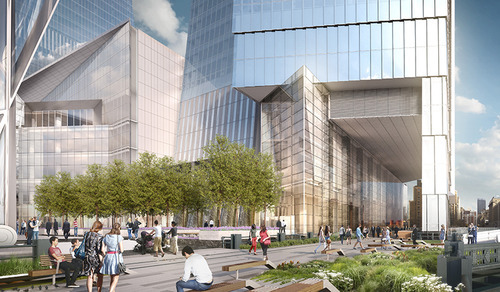
Urban Land Magazine recently published an interesting article on the Hudson Yards project in New York, which is the largest private real estate development project ever undertaken in the United States. Click here for the article. Thanks to my friend Evan Schlecker for passing it along. It’s a good read.
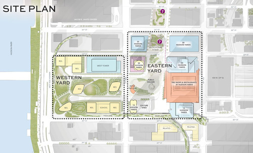
The project is being co-developed by Related out of New York and Oxford Properties out of Toronto, and when it’s all said and done, it’ll be over 17 million square feet of commercial and residential space. It’s a $20 billion development project.
But beyond just being massive and epic, there are a bunch of other things that make this project unique. You can read about them all in Urban Land, but I’d like to share a few snippets with you all here:
The first is about the project’s placement on top of a rail yard:
In order to make use of a site already occupied by a working rail yard—including more than 30 tracks for the Long Island Rail Road and three train tunnels, with a fourth under construction—most of the development will be built atop two steel-and-concrete platforms. That base, and the buildings on it, will be supported by hundreds of concrete-filled caissons, which will be drilled between the rail lines into the bedrock.
Because the location of the tracks and tunnels limits the placement of caissons, only 38 percent of the site can be used to support buildings.
The second is about the project’s use of technology:
Beyond that, a vast number of sensors embedded in the site’s infrastructure will collect mountains of data on everything from temperature and air quality to pedestrian and vehicle traffic. That information, which will be scrutinized in real time by managers in an effort to fine-tune Hudson Yards’ operation, will also be shared with New York University (NYU) researchers, who will turn Hudson Yards into a laboratory for studying urban life and finding ways to improve its quality.
And the last one is about how it interfaces with the High Line (click here if you don’t know what that is):
Pedersen [of Kohn Pedersen Fox Associates] found an intriguing way to address the building’s surroundings. He allowed the High Line—a public park built on a historic freight rail line elevated above the West Side—to penetrate underneath the tower through a 60-foot-long (18.3 m) public passageway, so that the building will interact with the park and its visitors. Inside the building, a dramatic atrium “becomes the terminus of the High Line as it moves from south to north,” he says.
So there are a lot of interesting and exciting things going on with this project. What’s amazing though is how “vertical” this community will be. You have rail lines below grade. Platforms on top. Retail at grade and across multiple levels. And an elevated linear park cutting through the buildings. Not every city can make this work. New York can.
I received an email from an ATC reader yesterday who is working on a publication about reimagining public spaces in Toronto. She sent me a few questions and specifically wanted to talk about the Yonge Redux project, which I wrote about a month ago. After I responded to her questions, I figured I should just share them publicly. So here they are:
How would citizens from different age groups benefit from the Yonge Redux project?
I would bet you that this stretch of Yonge Street experiences more pedestrian traffic than it does car traffic. And yet we’ve allocated space in the opposite direction: cars have more space than pedestrians do. So what this project is really about is reallocating the street, or public right-of-way, so that the dominant uses are actually prioritized through urban design. It doesn’t need to be more complicated than that. Ultimately, this will benefit people both young and old.
Do you know what kind of professionals are needed to complete a project like this?
You’d need an architect/designer – one who is awesome at landscape/urban design work. gh3 here in the city comes to mind as a firm I like, if you want an example. You’d need a bunch of engineers to deal with stormwater management and other infrastructure items. You’d likely need a transportation/traffic consultant to assess traffic flows in the area and prove that this project won’t cause the entire city to come to a grinding halt (it won’t). You would need someone to manage the day-to-day of the entire project. And this is just naming a few of the professionals/consultants that you’d probably end up needing.
You’d also have to work closely with the city, the local councillor, and the local community. It’s inevitable that some of the businesses will worry about the loss of potential customers – so that would need to be worked through.
What are some areas in Toronto that, in your opinion, need reimagining in the next few years?
My feeling is that Toronto is still at the early stages of this shift towards better public spaces and a better public realm. But in many ways, projects like Yonge Redux are much easier sells compared to the other areas that could use a face lift. Yonge Street is already urban and pedestrian friendly. The real challenge is going to be dealing with the areas outside of the core – most of which, frankly, aren’t that welcoming to pedestrians and aren’t all that urban. What do we do with those? And do the local communities even want them transformed? They’re going to be much harder to reimagine (though I’m not saying we won’t be able to do it).
Where do you see the future of Toronto’s public spaces in the next 50 years?
All signs point to a more dense, more urban, and more transit-oriented city. With that shift, we’re going to increasingly realize the importance of incredible public spaces. So if we continue down this path, I reckon our public spaces will only get better. I’m optimistic about the future.
How would you personally approach a project like this?
My understanding is that this project has legs. It just has to work through the city bureaucracy at this point. Jennifer Keesmaat supports it.
Depending on who you ask, the current condo boom in Toronto might be viewed as either a good thing or a bad thing (most will have an opinion). Some people think we’re simply building too many condos. And that too many of them are small, crappy, and geared towards investors – as opposed to end-users.
While I do agree that we could be doing more to create complete communities – that is communities which serve everyone from young singles to families with 3 kids – I think there are also a lot of positives associated with Toronto’s condo obsession (full disclosure: I’m a real estate developer). It has made us more sustainable, more reliant on alternate forms of (non-car) transport, and it has made us a generally more exciting place to live.
But that doesn’t mean we can’t do better.
Lately I’ve been wondering about how other cities do it. Specifically, those European cities that somehow seem to always be able to build awesome housing projects. So today I thought I would pick one and profile it. What I really wish I had was a financial pro forma to share with you all, but in the absence of that, I’ll try and back into some of the numbers on my own.
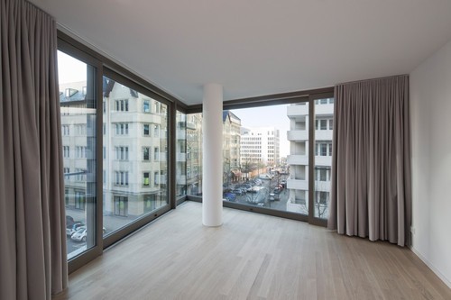
Shown above is the 9-storey Charlotte Apartments in Berlin. It was developed by WI Concept and designed by Michels Architecture Office. I chose this building because I think it’s an attractive one and because it’s of the (mid-rise) scale that Toronto is trying to promote along its many avenues. Here are the stats I was able to find online:
Site area: 347 square meters / 3,735 square feet
Building area: 3,000 square meters / 32,291 square feet (says gross floor area, but I don’t know if that means the same thing as it does here)
Construction costs: €3.6 million / C$5,065,691 (as of today’s rate)
Units: 28 (sold within 1 week of launch)
Market: ~70% of buyers in Berlin are believed to be foreign investors
Now, if we were actually building a development pro forma, we’d want to get a lot more granular in our calculations than what I’m about to do. We’d want to know gross construction area, net saleable areas, and so on. But for the purposes of this post (and because I have very little information), I’m going to simplify and do a back of the napkin set of calculations.
Based on above, the FSI (or density) is about 8.65 (32,291 sf / 3,735 sf). That’s roughly in line with many of the residential developments we’re seeing in downtown Toronto. The average unit size works out to be about 1,153 sf (32,291 sf / 28 units), but in reality it would be less if that 32,291 number is truly the gross floor area. You would need to subtract the corridors and other non-saleable areas from it before doing this calc. Either way, that is big compared to most downtown Toronto condos, but small for Berlin standards according to this ArchDaily article. Finally, if we look at construction costs, we get $157 per square foot in Canadian dollars ($5.065M / 32,291 sf). That’s low. I wonder what the land costs were.
Again, these numbers are rough rough. But I wanted to try and dissect a European development project and compare it to Toronto. The most surprising figure seems to be the low construction costs. If you have any additional insights, I would love to hear from you in the comment section below.
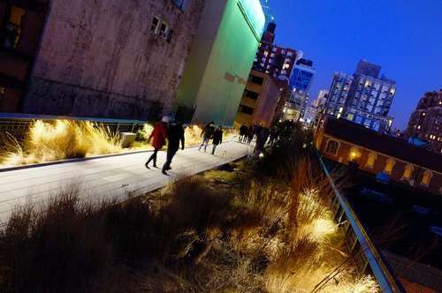
In 1980, the last train ran on an elevated corridor on the west side of Manhattan known as the High Line. Originally built in the 1930s, the trucking industry had made these trains obsolete and service was halted.
At this point, neighboring property owners began to lobby for the demolition of the High Line, as they no doubt saw it as an opportunity to increase the value of their land holdings. But thanks to local residents – most notably a man by the name of Peter Obletz – the 1.45 mile-long elevated rail corridor was saved from demolition.
In 1999, Joshua David and Robert Hammond then decided to form a non-profit with the goal of both preserving and reusing this unused rail corridor. The group was called Friends of the High Line.
By the early 2000s, Friends of the High Line had successfully made an economic case for transforming the rail line into a public open space and things started moving forward. Initially, it was thought that a public park of this sorts would attract about 400,000 people annually and generate upwards of $286 million in new tax revenues over the following 2 decades (Globe and Mail).
With these expectations in mind, construction on the new High Line Park began in 2006. The first section opened in 2009 – a decade after Friends of the High Line was formed. And the third, and last section, opened just two weekends ago at the end of September.
Today the High Line Park attracts 5 million visitors a year and is believed to be directly responsible for about $2.2 billion in new economic activity. The increased tax revenues over the next 2 decades are expected to reach about $980 million. Without a doubt, the High Line has been a huge success. It has become the 2nd most visited cultural attraction in New York (Globe and Mail).
Which is why every city now wants their own High Line. Philadelphia wants one. Chicago wants one. Mexico City wants one. Seoul wants one. And the list goes on. Here in Toronto, we’ve recently proposed one called the King High Line, which will connect the Liberty Village and West Queen West neighborhoods across a rail corridor.
While I do believe that this is an important connectivity problem to be solved, I worry about how explicit the references are to the actual High Line. Even the street furniture is the same in their promotional video.
I worry not only because it means we’re clearly taking on the role of follower, as opposed to leader, but because an elevated park isn’t going to work in all urban contexts the same way that the High Line worked in Chelsea. This is similar to how Frank Gehry can’t magically turn your city into the next Bilbao.
So while I have shown my support by becoming a “Friend of the King High Line” (and I would encourage you to do so as well), it’s important to keep in mind that the problems we’re trying to solve here aren’t necessarily the same ones that New York had to deal with.
The High Line – from the start – was designed to have an intimate relationship with its surrounding buildings. The tracks rain directly through them so that the trains could easily load and unload their cargo – that was the whole point. So when the High Line was redone, all of a sudden these buildings were able to reconnect themselves to the park in a way that they were already accustomed to doing.
But in Toronto’s situation, and perhaps in your city, that’s not the case. We’re talking about stitching together two completely disconnected neighborhoods. It’s a noble goal and certainly one that I wholeheartedly believe we should pursue. But I don’t think we should assume that it’s a problem that has already been completely solved for us.
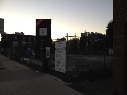
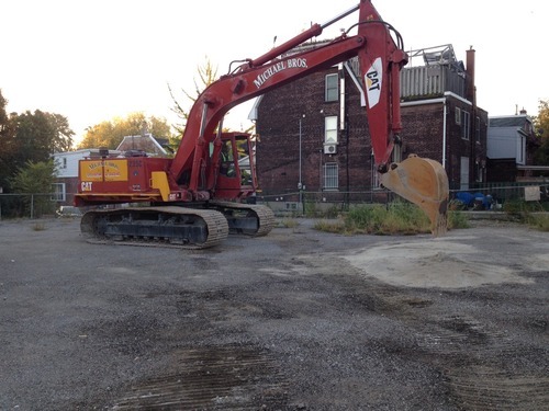
Below was the scene at the DUKE Condos site in The Junction last Saturday morning at 7:00AM. Michael Bros. mobilized their equipment to begin site preparation so that shoring and excavation can begin. The plan is to be at the bottom of the hole by the beginning of next year.
We’re all very excited in the office and so I half jokingly told our VP Construction that I would meet him on-site at 7:15AM with beers. He responded with a one word email saying: champagne. In the end, I decided to go swimming instead (probably a better decision), but I am sure we’ll have a drink soon.
There are still some killer suites available at DUKE, so feel free to drop into the sales office at 2800 Dundas Street West, give the sales team a call at 416-800-7738, or tweet the TAS team with any questions.