Daily insights for city builders, delivered every morning at 6 AM ET. I’m Brandon Donnelly — a Toronto-based real estate developer and founder of Globizen. I’ve been writing here since 2013.
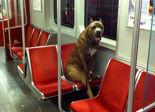
This afternoon I rode Toronto’s new streetcar for the first time on my way home from Chinatown. I had been meaning to do it for weeks now, but this was my first opportunity.
The experience was infinitely better than what you get today on our current streetcars. I felt like I was in a new city. The proof-of-payment system makes onboarding much faster and the 4 loading doors means you just get on the train where there’s the most room – instead of getting on at the front and fighting your way to the back.
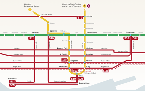
The other thing I liked is that they now have a map of our streetcar network within the train (see above image). Toronto never used to do this. For whatever reason, we didn’t like mixing subway lines with streetcar lines on the same map.
But why be so pedantic?
For one thing, our subway map looks pathetic without these additional streetcar lines on it. So for the sake of Torontonian morale, please fill it up with what you can.
But the other reason why I think it’s important to include them is that we shouldn’t be thinking about our cities just in terms of specific technologies (subway, streetcar, and so on). Our cities are now multi-modal. Which means we navigate them using many different means, from subways and streetcars to bikes and Uber cars. What people care about is getting from A to B in the most efficient and enjoyable way possible.
This may seem like a subtle distinction, but it’s an important one. And maybe, just maybe, these new maps will serve as an important reminder to us that there’s a lot of fixed rail in this city and that it could be far better optimized if we just tried a little harder.
“We shape the cities, and then our cities shape us.” That’s one of my favorite lines from the documentary The Human Scale, featuring Danish architect and urban designer Jan Gehl. I like it because I don’t think many of us think enough about the way in which the built environment – that we create – ultimately goes on to influence the way we live our lives.
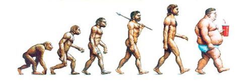
One of the most interesting connections for me is the link between urban form and public health. There’s been a lot of talk over the years about how suburban sprawl is, or might be, making us fat (among other things). We’ve created environments that are only navigable by cars and that has forced many of us into sedentary lifestyles. We sit in our cars, and then we sit in our offices.
So today I’d like to conduct a bit of a poll. If you’d like to participate, please share the following 3 things in the comment section below: 1) your city, 2) the type of neighborhood you live in (urban, suburban, rural, etc.), and 3) the amount of time you spend walking or doing something active on an average day.
Here’s me:
I live downtown Toronto in the St. Lawrence Market neighborhood (urban). I take the subway to work and the station is a 10 minute walk from my place. So as a bare minimum, I spend at least 20 minutes a day walking. But since I also walk to do most of my regular errands, and since my gym is another 10 minute walk from my place, I’d say I average a good 30-45 minutes of walking each day.
Now it’s your turn 🙂
This is a pretty crude survey, but with the advent of things like smartwatches and health monitors, I think we’ll soon have lots of great data on the ways in which our cities might shape our health.
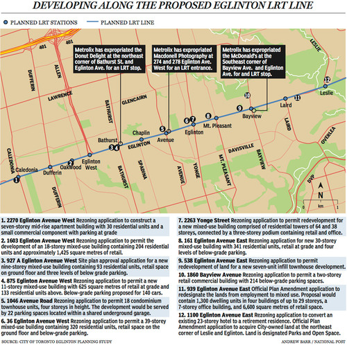
Last week The National Post published an article talking about Toronto’s Crosstown LRT and how it’s spurring a wave of development all along Eglinton Avenue. Below is a map, taken from that article, showcasing some of the developments that are currently in the pipeline and awaiting the Crosstown’s opening date of 2020.
Not surprisingly, developers like transit investment. But more specifically, they like fixed track transit investment. Rarely do new bus routes elicit the same sort of response that you’re seeing above. And that’s because fixed track investment has permanence. If you’re going to go long on an area, you want certainty.
As the Crosstown tunnel boring machines move across midtown Toronto, I thought it would be interesting to look at a transit concept that I first learned about through Jarrett Walker’s Human Transit blog. It’s called: the radius of demand.
One of things that transportation planners look at when designing and building a new line is the spacing of stops. Typically, as you move from buses all the way up to subways, the spacing between stops and stations increases. Spacing is always a bit of a trade off though, because more stops means easier access for riders, but it also means slower overall service. Somewhat famously, Paris designed its metro system so that you’re rarely more than 500 meters away from a station.
Once you have your station locations, it’s quite common to then draw a radius around each stop to simulate the catchment area. In other words: How much of the city can I service with this station and how far will people be willing to walk in order to get there? However, this distance, which is the radius of the circle, usually depends on the type of transit. Oftentimes people are willing to walk further in order to get to faster transit service.
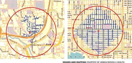
But what’s most interesting about this radius of demand is that it’s entirely dependent on the fabric of the city. Take for example, the following two maps from Seattle, which I have taken from Walker’s blog. On the left is a suburban setting and on the right is a downtown setting. In both cases, the red circle represents a 1 km radius.
Now, if humans could fly over barriers, such as highways, and every Seattle resident was willing to fly exactly 1 km to a transit station, these two radiuses of demand would be perfectly accurate. But since that’s not the case, we instead need to look at what actually represents a 1 km walk – those are the blue lines in each image.
Because once you do that, you realize that the cul-de-sacs and highways on the left make it impossible for most of that radius of demand to actually walk to the station in under 1 km. So the catchment area actually becomes much smaller. On the other hand, if you look at the image on the right, you’ll see that the tried and true city grid is actually remarkably efficient for walking. Almost all of the circle is serviced.
So as the Eglinton Crosstown LRT makes its way through the center of Toronto, I think it’s important to keep in mind that it’ll be cutting through quite a few different kinds of street grids. Some of them will be highly conducive to transit usage and others not as much. And in many ways, this is one of the greatest challenges of transit investment. The track itself is only one part of the puzzle.
That’s why the City of Toronto is also undertaking a planning exercise called Eglinton Connects. Its intent is to leverage the opportunities, as well as address the challenges, that will result from Metrolinx’s Crosstown LRT. If you’re interested in the future of Eglinton Avenue, you should consider getting involved. Oftentimes it’s only the critics that speak up. But that’s not the best way to build anything.
I take the subway to the office every day and oftentimes I find myself standing there thinking about what the most efficient subway car interior would look like. I guess it’s the architect and designer in me, but I keep trying to rethink the seating arrangement.
My first thought is always that the perpendicular seats that shoot out into the middle of the train are a complete waste of space. If you’re tall (I’m 6’3”), they’re actually uncomfortable to sit in. Every time I do, I feel as if my femur is too long for the allotted space.
One top of that, nobody ever wants to sit in the interior seat—primarily, I think, because they’re cumbersome to get in and out of when somebody is sitting beside you. So you end up with a countless number of cases where those benches are only half occupied.
But what’s really interesting about this thought exercise is that it can’t be done without also closely analyzing human behavior. Here’s what I’ve noticed here in Toronto.
People want to be as far away as possible from other people on the subway. It’s weird to sit beside someone unless you really have to. In fact, try this exercise: Walk onto a sparsely populated subway and sit directly beside somebody. I bet you that person will move and/or give you a dirty look.
What this means is that the end seats always fill up first. People don’t want middle seats, which, I’ve learned, is why they put grab poles in the middle of benches longer than 2 seats. They’re trying to simulate an end seat and make that middle seat feel less like it’s, well, in the middle. You get a pole in between you and the person next to you.
But before sitting in the middle seat, most people would rather stand. Standing is preferable to rubbing shoulders with someone, unless the subway train gets really busy, in which case people will start to sit anywhere. Typically people like to stand right beside the doors, because there’s a place to lean and it’s easy to get off when your stop comes. But this isn’t ideal from an onboarding and offboarding standpoint. It’s people in the way.
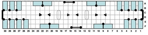
Of course, there are many others who have spent a lot more time than me thinking about this topic. A quick search revealed this Wired article talking about this very subject. And below is the layout that they recommend. The design is from the Transportation Research Board.
Their recommendation is to basically remove the seating around the middle doors, so that it’s easier for people to get on and off the train, and to stack airplane style seating towards both ends. In this scenario, the middle gets optimized for standing and the ends get optimized for sitting.
Now it’s your turn. Do you think this would be better or worse than what you have today in your city? Let me know in the comments below.
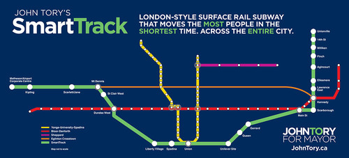
Yesterday Toronto mayoral candidate, John Tory, proposed a transit line called SmartTrack. It’s part of his One Toronto transit plan. If you’re interested in watching the full 30 minute announcement, click here.
As somebody who came out of the gate as a strong proponent of the “Yonge Relief Subway Line” (and as somebody I immediately supported for that reason), this proposal first hit me yesterday as a disappointment. Not because I don’t think we need a regional express rail network in the region (we do), but because I feel that he is backing away from that initial commitment and depriving the core of the transit infrastructure it needs.
As soon as I found out about the plan, I immediately emailed one of my friends at Metrolinx. I told him I thought it was an “epic fail”. He pushed back and asked me to consider the merits of Tory’s plan. After having slept on it (and calmed down), I’m now prepared to talk about both the benefits of SmartTrack and why I was disappointed.
SmartTrack is basically a regional rail plan, intended to move people from the outer and inner suburbs to and from downtown using an integrated fare system. That is, riders will not have to pay a separate fare to transfer from subway to SmartTrack. 90% of the track needed for the plan is already existing, which means it will be cheaper and quicker to build compared to the full relief subway line. It will also bring employment centers such as Airport Corporate Centre in Mississauga into the transit network. For these reasons, the SmartTrack plan would certainly be beneficial for the region.
But, there’s a densities mismatch.
If you look at the number of stops proposed in Scarborough and Markham, and compare it to the number of new stations proposed for downtown (1 – Spadina station) and the downtown shoulder neighborhoods (2 – Liberty Village and the Unilever site), the plan starts to look lopsided. SmartTrack would help residents of downtown get out to the suburbs, but it would do little to help them move in and around the core.
If you look at the way Toronto is intensifying on a map, it looks like an upside down letter T. Density now hugs the waterfront and then follows our subway lines up north. I believe that the SmartTrack plan would help to relieve the pressures on those subway lines, but I don’t think it adequately addresses the bar of the T that now runs parallel to the lake.
So while I do think that the Toronto region would be well served by regional express rail, I don’t think we can forget about the central part of the city. This shift in focus may have something to do with where Tory believes his voter base now sits, but let’s not forget that there’s a strong correlation between population density and transit ridership levels.
Now, let’s hear from you. What do you think of Tory’s One Toronto plan and SmartTrack proposal?
Last Sunday the Toronto Star ran this article talking about a $30 million class-action lawsuit against developer Elad Canada. The claim is that the developer failed to deliver on the promise of direct underground subway access from its project—Emerald City Condominiums—to the Don Mills subway station.
The developer, however, doesn’t feel that they made such a representation:
The lawyer for condo developer Elad disputes the claim saying, “there was never any representation that there would be underground access” from the condo building to the subway or directly to Fairview Mall: Both are easy to reach by walking out the lobby doors and six metres to the subway entrance right out front.
Emerald City is also a commuter’s dream come true. With easy underground access to the Don Mills subway, you can be in downtown Toronto in just minutes.
Now, I suppose you could argue that, since it’s the subway, that all access is underground. And that it’s certainly “easy”. But when I read the above statements, I can understand why somebody might think there’s underground access to the subway station from within the building. That’s what I would think. It’s misleading.
But I want to hear from all of you (especially if you’re a lawyer).
Do you think the developer unfairly led purchasers into believing that they would have direct and underground access to the subway station from their building?
Toronto is a city of neighborhoods and small main streets–at least in the areas where our streetcars live. Streets such as King and Queen are only 4 lanes. And the problem we’re facing is that we’re trying to accommodate every single use case on them: cars, on-street parking, cyclists and streetcars. But in doing so, we’ve made the experience terrible for everybody. Streetcars move at a snail’s pace, drivers are frustrated by the lumbering streetcars, cyclists fear for their life driving by parked cars (doors can swing open at any time), and so on.
And with the rise of downtown shoulder neighborhoods such as Liberty Village, King West, the Distillery District and the soon to be complete West Don Lands, the strain on our east-west corridors is only going to get worse–much worse, in fact. Already the King streetcar is the busiest streetcar route in the city, moving almost 60,000 people per day. That’s more than the (under utilized) Sheppard subway line.
What I hope is clear to the ATC community though, is that the answer isn’t uniformly the car. We can’t have every single resident from Parkdale to Leslieville hopping into their car and driving downtown to their office at Yonge & King. It ain’t going to work. And so we’re going to need to make some difficult decisions about how we’re going to get our city moving on the backbone of transit.
Sure the downtown relief subway line (screw the politics I’m attaching it to downtown) would be the ideal solution to connecting our emerging shoulder neighborhoods, but that’s not going to happen overnight. And so how do we improve the efficiency of what we already have? First, we need to accept the fact that every street isn’t going to be everything to everyone at all times. We need to choose who we want to optimize for.
So here’s an idea that’s been floated many times before but never acted upon: let’s get rid of cars on King St and Queen St in the core during rush hour.
This would give our streetcars the room to efficiently move people across downtown, minimizing the dreaded “bunching up” that occurs as a result of traffic congestion. It would make transit a reliable choice and there are ways to pilot it. But let’s be clear: this is not about being anti-car. It’s about optimizing uses and getting people moving. Cars would continue to get priority on Richmond St and Adelaide St, and transit riders (as well cyclists) would get priority on King and Queen.
Of course, the Rob Ford viewpoint would say that we should be optimizing all streets for cars and getting the streetcars completely out of the way. But if that’s the approach we want to take, then we’re building the wrong kind of city. We shouldn’t be focused on intensifying and creating new inner city neighborhoods, because that only tips the scale in favor of transit. Instead, we should be focused on decentralization.
But that’s what not we’re doing. We’re intensifying our city to the point that we’re now faced with a number of difficult–yet enviable–decisions about how we’re going to live and how we’re going to move around in the future. We’re a city in transition.
Our mission here should be to figure out how to move people around the city as efficiently possible. Let’s put politics aside and recognize that time is one of our most precious resources. And when we put people in lumbering streetcars and debilitating traffic jams, we’re completely squandering that resource. It hurts productivity and it hurts our overall prosperity as a global city.
There’s a place for subways, streetcars, buses, bikes and cars in our city. So let’s just get on with making them all work.
Last night before bed I decided to buy a book on my Kindle (iPad app) that I’ve been meaning to read for awhile. It’s called Poke the Box and it’s by Seth Godin. It’s a short read and it’s meant to be that way. You could easily read it in one sitting.
The book is about taking initiative. Taking action. And drawing your own map. It’s about not being scared of failure and realizing that failures are how you learn. It’s about poking the box, which is a computer programming reference. Programmers learn by poking the box (computer) and seeing what works and what doesn’t work.
“Every employee in a company depends on the CEO to make fast, high quality decisions. Often any decision, even the wrong decision, is better than no decision.”
Both Godin and Horowitz are, in a way, talking about the same thing: You have to keep moving. Make decisions. Start stuff. And stop worrying so much about being wrong, because it’s virtually impossible to know how things will eventually play out in the future.
A perfect example of this is Starbucks.
The first Starbucks in Seattle didn’t sell brewed coffee. It sold beans. And had it continued along this path, it certainly wouldn’t have become the brand that it is today. In fact, it may have failed completely. It wasn’t until Howard Schultz saw what they had started and combined it with what he had learned in Italy, that the Starbucks experience of today was born.
The important thing is that somebody (Jerry Baldwin, Zev Siegl and Gordon Bowker) took the initiative to start and build a Starbucks. It didn’t matter that they got the recipe wrong, they poked the box and it ultimately lead to something magical.
The same reluctance to poke the box can also be found in city building.
Here in Toronto we spend a significant amount of time debating and vacillating around transit decisions (as well as many other things). Should we build LRT? Or should we build subway? What should we replace the Scarborough Rapid Transit line with?
But we’ve fallen into analysis paralysis.
The original Transit City Plan was announced on March 16th, 2007. It’s now 2014. And transit still sucks. Imagine if we started and finished, say, 2 kilometers of rapid transit each and every year. Forget worrying if it’s LRT, subway or a horse drawn space ship. We just kept moving.
Something tells me that we’d be better off, even if we did make a few mistakes along the way.
I was cruising the twitter sphere yesterday when I came across the following chart, outlining the various transit vehicle capacities here in Toronto. It was created by Cameron MacLeod of #CodeRedTO, which is a grassroots group advocating for “a rational, affordable, and achievable rapid transit strategy for Toronto.”
On the left you have the vehicle type and then you have the capacity in terms of number of seats and standing room. The planned capacity is essentially the sum of those two numbers and the “unsafe crush load” is the number of people you could fit if you really put your back into it.
Articulated buses refer to the longer (1.5x) bendy ones and, similarly, ALRV streetcars are the longer, articulated version of our regular streetcars. The low-floor streetcar is similar to what Toronto will be getting. And SRT is the Scarborough Rapid Transit system.
The chart also compares between vehicle types: How many cars would you need to move the same number of people? How many buses? And so on. As one example, you would need 15.9 buses or 982 cars to move the same number of people as the Yonge subway line!
What’s missing from the above chart though is light rail transit (LRT), which is comparable to the linking of up to 3 low-floor streetcars. In the case of the under construction Eglinton Crosstown LRT line, the planned capacity is 750 people!
This is an hugely important takeaway because many people, including our own Mayor, do not properly distinguish between streetcar and light rail. The two are not one and the same. LRT has the potential to move a lot more people.
In fact, at 750 people, the Eglinton Crosstown could move more people than the Sheppard subway line, which is only operating on 4 cars (as compared to 6 on our other subway lines).
So while it’s all fine and dandy to bang our fists on the table and advocate for subways, they don’t make economic sense in all parts of our city. With the Sheppard line, we’ve been leaving capacity on the table and wasting taxpayer money.
Of course this chart is also useful for those outside of Toronto. What I like about it is that it clearly shows the tool chest available to cities when it comes to building transit. Every city and neighborhood is different. And I think it’s important to have intelligent conversations about what makes sense in each.
Instead of talking about the latest Rob Ford scandal (honestly, how is he still mayor?), I’d like to focus on his abilities as a transportation strategist.
In another committee room, councillors were debating the proposed downtown relief subway line — only, they were afraid to name it such. Downtown is a section of the city that dares not voice its name, for fear that aggrieved suburbanites will rise up and object.
This is not hyperbole. Not long ago, the mayor indicated he is not interested in the relief line until there are subways on Sheppard East and on Finch West. Why? Because downtown “has enough subways.”
Downtown has enough subways? Do you think Ford looked at population density, number of stops, ridership levels, and so on, in order to come up with this position? Or did he just look at where his voter base resides?
We need to get past this downtown vs. suburban schism. We’re all in this together. In fact, the whole Golden Horseshoe region is in this together. And until we start acting as a unified entity, we’re not going to reach our full potential.