Daily insights for city builders, delivered every morning at 6 AM ET. I’m Brandon Donnelly — a Toronto-based real estate developer and founder of Globizen. I’ve been writing here since 2013.

Tag: subway

  • The Scarborough Subway Extension is a mistake

    Last weekend over dinner, a friend of mine asked me what I thought about the Scarborough Subway Extension debate going on in Toronto right now. Costs are coming in higher than initially projected and the usual back and forth is taking place. Transit blogger Steve Munro has a good post on this called Spinning a Tale in Scarborough.

    I haven’t written much about the Scarborough Subway, but I do have a strong opinion. I believe it’s a mistake. I am not saying that we shouldn’t be building higher order transit in Scarborough – we absolutely should – but it does not need to be an expensive subway line. There are more sensible solutions.

    Here are a few things to consider:

    Light rail transit (LRT) does not equal streetcar. As an avid user of the King streetcar, I’ll be the first to admit that something needs to be done to address the city’s busiest streetcar routes. They are broken. But this is not what was being previously contemplated for Scarborough. True LRT – which Toronto does not yet have – is far more effective at moving people.

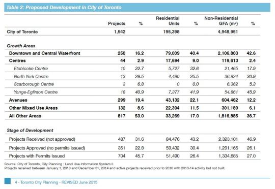
    Scarborough Centre is seeing almost no new residential and commercial development. In fact, the “Centres” in general are not seeing much development. The largest share is happening downtown, along the central waterfront, and along the “Avenues.” We shouldn’t ignore this when making our investment decisions. Transit and built form go hand in hand. 
    I also do not buy the argument that we are building this subway in anticipation of demand 50 or 100 years from now. We are not in a position to be proactive about our infrastructure. We are desperately playing catch up and there are already lots of high growth and high density areas in the city which today are completely underserved by higher order transit. 

    Finally, a new subway line with low ridership will mean higher operating cost subsidies to keep it afloat. And at the rate that Scarborough Centre is growing today, this would likely continue for many years into the future. Not only is this debate about spending money today, it is about spending money well in the future, month after month.

    So let’s be clear: the Scarborough Subway Extension debate is about politics. It is not about transportation planning.

  • 100 years since Cincinnati tried to build a subway

    image

    I can get lost on Google Maps for hours on end. I love looking at maps and I love using Street View to virtually explore cities. This morning I’m honed in on Cincinnati, Ohio (a city I’ve never been to) while I listen to this podcast about their unfinished subway.

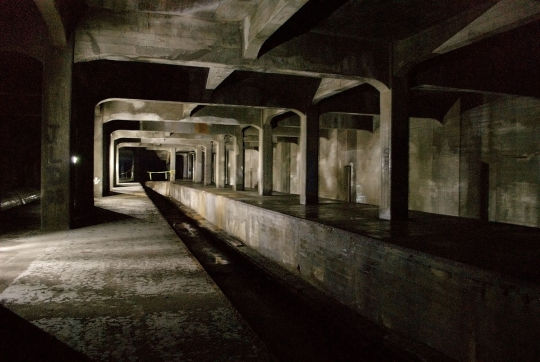
    In 1916, the city voted in favor of spending $6 million on a new subway. But it was never finished and so today – 100 years later – it has the dubious distinction of being the largest abandoned subway tunnel in the United States. 

    The podcast I’m listening to is with a fellow by the name of Jake Mecklenborg. He has written a book on the subway’s history and has emerged as the expert on this topic. And it all started with him just throwing up a website.

    One particularly interesting aspect of the subway is how it tied into the city’s flooding problems. At the time, the population density of the constrained downtown was surging and the subway was viewed as a way to stitch together desirable land and relieve some of those urban pressures.

    I’m also very interested in understanding how cities got founded in the locations that they did. As in, who was the person who dropped their bag and said: “yup, this, is the spot.” Somebody had to have made a decision.

    Oftentimes there were specific strategic, economic, and/or environmental reasons for a certain location. And this is something that Jake touches on. In the case of Cincinnati, flooding was again a major determining factor. 

    If you can’t see/listen to the podcast through the embed below, click here.

    //html5-player.libsyn.com/embed/episode/id/4210424/height/90/width/580/theme/custom/autoplay/no/autonext/no/thumbnail/yes/preload/no/no_addthis/no/direction/backward/render-playlist/no/custom-color/87A93A/

    Image: Jonathan Warren via Wikipedia

  • Ziggurats and gondolas

    Yesterday was an exciting day for Toronto city building announcements. 

    Firstly, Alex Bozikovic of the Globe and Mail published an exclusive preview of architect Bjarke Ingel’s plan for King Street West. Here’s a photo of the architectural model (it’s by Landon Speers):

    My favorite quote from the article is this one from Bjarke:

    “It would be sad if the most diverse city in the world had the most homogenous real estate.”

    It’s true.

    For those of you who emailed me about the details of his talk next week (there were a lot of you!), I believe I emailed you all back. But in case I missed some of you, you can click here for the event details. I should have included it in my original post about BIG, but I thought the event was already oversubscribed.

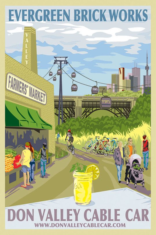
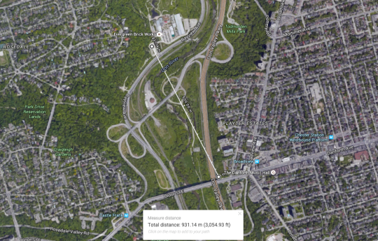
    Secondly, a private company called Bullwheel International Cable Car Corp. has just proposed to build a $20 to $25 million gondola running from Danforth Avenue (near Broadview subway station) to the Evergreen Brickworks. The total length would be almost 1 km and it, allegedly, wouldn’t require any public money. Here is their website.

    The timing of this proposal feels a bit serendipitous to me. When I was in Park City, Utah a few weeks ago, snowboarding right into the town and then taking their “town lifts” back up to traverse the mountain, I remember thinking to myself: what a wonderful form of transportation this is.

    Of course, Park City has giant mountains and Toronto, unfortunately, does not. But we do have spectacular ravines and a spectacular institution known as the Evergreen Brickworks.

    But one of the challenges with our ravines is that they can be a bit hidden – particularly for visitors to the city. Part of this is because we are trying to figure out the right balance between natural preservation and active use. But that’s one of the things that makes this proposal so intriguing. It’s a way to celebrate our ravines and natural landscape, without physically encroaching it.

    Here’s a map of the proposed gondola path:

    What do you think about these announcements?

  • Out of sight, out of mind

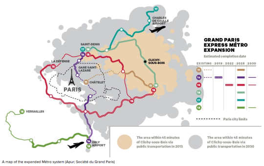
    Henry Grabar has an interesting piece in the March 2016 issue of The Atlantic talking about Paris’s ambitious metro expansion. By 2030, and after $25 billion of investment, the Paris system will gain four new lines, 68 stations, and more than 120 miles (192 kilometers) of track. 

    To put this into perspective, this additional track length is roughly equal to Toronto’s entire subway and streetcar network, including all under construction and approved lines.

    But the real focus of Grabar’s article was on how this transit investment will really stitch Paris back together:

    “Three of the new lines will run north and east of Paris, through Seine-Saint-Denis, the poorest of the 96 departments in France. Among French cities with at least 50,000 people, six of the seven with the highest percentage of foreign-born residents are in Seine-Saint-Denis. Residents of Clichy-sous-Bois, where the riots that swept the region in 2005 began, will for the first time find central Paris within a 45-minute train ride. The town of Saint-Denis, the site of the standoff between police and the terrorists who struck Paris in November, will be home to the project’s largest train station. Designed by the Japanese architect Kengo Kuma, the junction is expected to handle 250,000 passengers a day.”

    Below is a map (from the same article) showing the location of Clichy-sous-Bois to the east of Paris and the area reachable within 45 minutes from this suburb, both today and in 2030 when the new metro lines open.

    Having traveled to Paris in 2006, shortly after the riots took place, I remember some Parisians telling me that this was not a Paris problem. They told me that this was a problem of the banlieues, but not of Paris. Seeing how separate Clichy-sous-Bois is today, that is probably how it felt to some or most. But based on the above, the Paris region is about to be stitched together.

    What I love about Grabar’s article is this idea that transit and connectivity represent a kind of citizenship for urban residents. And that even today, in our hyper connected world, physical access matters a great deal. Because without it, you might be out of sight, out of mind.

    On that note, here is how the article ends:

    Benoît Quessard, an urban planner for the local government, told me that he sees the expansion as not merely “an economic wager but also a social one.” In this sense, it will test an old Parisian belief about the Métro conferring, beyond convenience, a kind of citizenship on its riders. In 1904, four years after the first line opened, the writer Jules Romains predicted that the system would be a “living, fluid cement that will succeed in holding men together.”

  • Bringing public transit into the 21st century

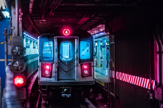
    New York Subway by Lok Yiu Cheung on 500px.com

    https://500px.com/embed.js

    I think we’ve hit peak millennial.

    Last Friday the Governor of New York, Andrew Cuomo, and the Metropolitan Transit Authority, announced that 30 subway stations will be redesigned and that “millennial-friendly amenities” would be added throughout the system. 

    As you might guess, this includes adding phone chargers in train cars and buses and wifi throughout all the stations (by the end 2016). They will also be replacing the MetroCard with an all digital fare system that will include mobile payments.

    But the reality is that this isn’t about being millennial-friendly. This is about joining the 21st century.

    Here in Toronto, we finally have our PRESTO card working on all streetcars and in almost 40% of the city’s subway stations. This is a huge improvement over our laughable and antiquated token system, but it’s not enough. I really hope the next rollout is a mobile app that will allow everyone to pay with just their phone.

    We also have wifi in about 30% of our subway stations, but again this is not enough. By the time you get authenticated (do you need to have Twitter now?), your train is usually arriving and then you enter a tunnel where no wifi exists. We need to be looking at the entire tunnel network. (Related topic: LinkNYC) 

    I say all this because I am a big supporter of public transit. Despite all the positive things I write about Uber, ridesharing, and driverless cars, I do not believe that they will eradicate the need for a strong transit backbone. This is fundamental to our city building efforts. 

    So let’s do our best to delight people when they take transit.

  • Uber, commuting, car ownership, and the future of urban mobility

    Earlier this week I wrote a “Tech Tuesday” post talking about Uber’s new Smart Routes functionality, which it is currently testing out in San Francisco. At the end of the post I ended by saying that it’s not just the taxi industry that should be thinking about Uber, it’s also public transit authorities. 

    And that’s because many people in cities rely on multi-modal forms of transportation (I know I do) and in my mind it is clear that Uber is trending away from just “Everyone’s Private Driver” to a service that is starting to look and feel a lot like urban mass transit.

    Then today my good friend Evgeny sent me a post called, “Public Transit Should Be Uber’s New Best Friend.” And it’s one of the best pieces I’ve read on Uber and its impact on urban mobility. I highly recommend you give it a read, particularly if you’re in the city building arena.

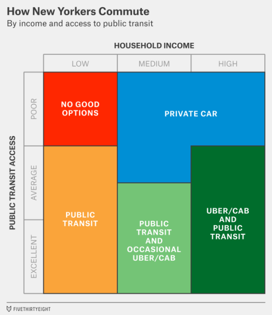
    The article does a deep dive into how New Yorkers commute. Here’s how they broke it down.

    image

    It then talks about what it will take for a company like Uber to make a meaningful dent in car ownership (which is one of the company’s goals) and how the truly big opportunity for Uber is to go more mass market and tap into the public transit market – either by interfacing with or by building its own version of it.

    Here’s their concluding paragraph:

    But there’s a much wider potential audience if Uber can also reach middle-class customers who want to save money. Perhaps in the distant (or even the not-so-distant) future, Uber can build its own version of “public” transit, making rides so cheap that they cost less than the $4 or $5 that Americans now pay, on average, to make a trip in their personal cars. In the meantime, it might have more success among “car-cutting” customers who can use Uber along with public transit. That might mean Uber’s growth is concentrated more in cities like New York, San Francisco and Chicago — and in Europe and Asia — that already have reasonably strong public transit networks.

    It’s definitely worth a full read. Thanks again for sending this over Evgeny.

  • The case for planning transit around minimum population densities

    Photograph Blitz by Tristan O'Tierney on 500px

    Blitz by Tristan O’Tierney on 500px

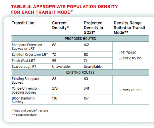
    Back in 2011, the The Pembina Institute published a report called, Building transit where we need it. And in it they quite clearly outlined the population densities that are needed to make various types of transit investment cost effective.

    For subway they specify a minimum population density of 115 people per hectare and for light rail (LRT) they specify a minimum population density of 70 people per hectare. 

    And the reason for this is because there’s a strong correlation between population density (i.e. land use) and transit ridership. The two go hand in hand and should not be decoupled. If population densities are too low (as they are, for example, along the Sheppard subway line here in Toronto), people don’t take transit. They drive.

    Here’s a chart from the report showing the current and projected population densities for Toronto’s existing and proposed routes (keep in mind this is from 2011).

    image

    So what does this chart tell us?

    • Subways don’t make a lot of sense in many parts of the city. LRT will do just fine.
    • The Sheppard subway line is an under-utilized asset. Even by 2031 we’ll barely be reaching the requisite population densities.
    • The Bloor-Danforth corridor could use more intensification.
    • The Yonge-University-Spadina line is going to need to relief.

    Unfortunately, transit decisions are often made based on politics instead of data. And that results in subways in places that don’t make a lot of sense. That’s unfortunate because it means less riders, less revenue, and more subsidies.

    The other challenge with running subways through low density neighborhoods is that it then creates tension when the city and developers go to intensify those neighborhoods through transit-oriented development. (See #DensityCreep.)

    But if we’re going to be fiscally irresponsible about where we deploy our transit capital, the least we could do is upzone the surrounding areas and impose minimum population densities. 

    In fact, here’s what I think we should do: Land use should be bundled with the transit decision. 

    Instead of asking where the subway station should go, we should be asking where the subway station should go and all the density needed to bring the area up to a certain minimum population density. And if that second criteria for whatever reason can’t be met, then we don’t build the line. 

    I wonder if we framed the question in this way if it would change where subway lines get approved. What do you think?

  • Toronto’s Bloor-Danforth subway corridor is a land use crime scene

    image

    Yesterday after my post on leveraging LRT, I stumbled upon an interesting and timely article written by Richard Joy, who is the Executive Director of the Urban Land Institute (Toronto).

    The article talks about some of the transit-oriented development that we’ve seen at various nodes along Toronto’s Yonge subway corridor (St. Clair, Eglinton, Sheppard, and so on). But it goes on to argue that these are exceptions to the rule. For the most part, we’ve missed the boat:

    The tragic history of our massive capital investments into transit infrastructure is massive under-development.

    Indeed, the Bloor-Danforth subway corridor is a land use crime scene.

    His main argument is that until we expand the supply of transit-oriented land (through increased intensification), we will continue to undersupply the kinds of walkable and transit-oriented neighborhoods that many, if not most, people actually prefer. And that, out of necessity, will force people into their cars. Because affordability trumps location preference.

    As one example, he talks about the intersection of Bloor Street and Dundas Street in the west end of the city. Next to Union Station, this is probably the best connected mobility hub in the region. You have the Bloor-Danforth subway line, a streetcar line, and a GO regional rail line which all feed into it. Next year it’ll also become a stop for the new express train to Pearson airport.

    And yet the city has a history of opposing intensification in this location, including the old Giraffe Condominiums proposed by TAS. Does that make sense to you?

    Image: Flickr

  • Leveraging LRT

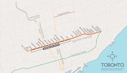
    One of the biggest pieces of infrastructure currently under construction in Toronto is the Crosstown LRT line, which will run on and under Eglinton Avenue right through the heart of midtown. The total length of the line is 19 km, and 10 km of it will be underground along with 12 of its stations.

    Here’s a map:

    image

    But as the Chief Planner of Toronto, Jennifer Keesmaat, rightly pointed out in this blog post earlier this year, it’s important to think of this line, not just as a piece of transit infrastructure, but as a broader city building initiative. With this line comes a tremendous opportunity to rethink and rebuild one of Toronto’s most important avenues.

    I have no doubt that this will happen over the coming years and decades. I mean, just look at the development activity taking place on St. Clair Avenue West right now, which you could argue is the result of its right-of-way streetcar line. But in this instance, what I’m specifically curious about is what will happen at each of the stations along Eglinton Avenue.

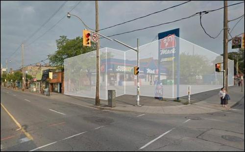
    If you take a look at the Stations and Stops page on the Crosstown website, you can see where all of the primary and secondary entrances will be and how each station will generally function. But what is not clear is whether we will be using this opportunity to build additional density on top of them.

    Here’s how they have “blocked out” the primary entrance for Avenue station:

    image

    I have no idea what it’ll become. But if it ends up as single-storey and single-purpose building, then I think we will have missed an opportunity. And the same goes for many, if not all, of the other stations along the Eglinton Crosstown line. Fixed rail is such a massive driver of real estate value, and so it seems silly not to take advantage of that in some way.

    If anyone has any insights into how these stations will or will not be developed, I would love to hear from you in the comment section below.

  • It’s voting day in Toronto

    Today is municipal election day in Toronto.

    About 8 months ago I publicly announced here on ATC who I would be supporting, and my position hasn’t changed. I was disappointed by the fact that he ended up backing away from his initial promise of a true downtown relief subway line (see blog post), but I nonetheless continue to support his candidacy.

    In the words of Mike “Pinball” Clemons, he’s “the right man at the right time.” Click here if you can’t see the video below.

    [youtube https://www.youtube.com/watch?v=ouqv782giyw]

    But I’m not here to try and sway your vote. That is ultimately your decision. However, I am here to encourage you to get out and vote. Regardless of who you might be supporting, I think it’s important that you get out and take a position. So I hope you do that today.

    Happy Monday!