Daily insights for city builders, delivered every morning at 6 AM ET. I’m Brandon Donnelly — a Toronto-based real estate developer and founder of Globizen. I’ve been writing here since 2013.

Tag: subway

  • The longest cable car line in the world is in Mexico City

    Mexico City is all kinds of big. It is the largest metropolitan area in North America, the largest Spanish-speaking city, and broadly one of the largest megacities in the world. Because of this, it can be, you know, hard to move around.

    I remember visiting the city for the first time when I was in elementary school, and it standing out to me that everyone had one day of the week when they were simply not allowed to drive their car. It was/is a form of load balancing. Imagine that. (I don’t know if this is still the case, or if it’s even more stringent today.)

    I also remember visiting the city later on, when I was in grad school, and it standing out to me that their metro had women-only cars. This was and continues to be an attempt to try and minimize the amount of sexual harassment that takes place on transit. Again, it can be hard to move around Mexico City.

    The city’s latest solution is one that has found success in other Latin American cities, such as Medellin, and that is: cable cars. Relative to subway or light rail, they’re inexpensive. They’re also good at navigating steep terrain, and their stations can be inserted into dense urban areas. This includes working-class neighborhoods who might otherwise have very limited mobility options.

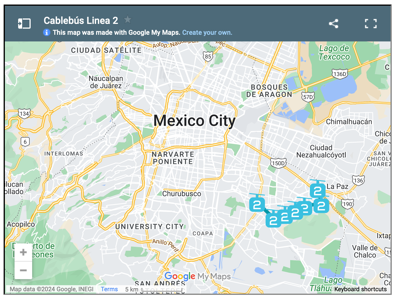
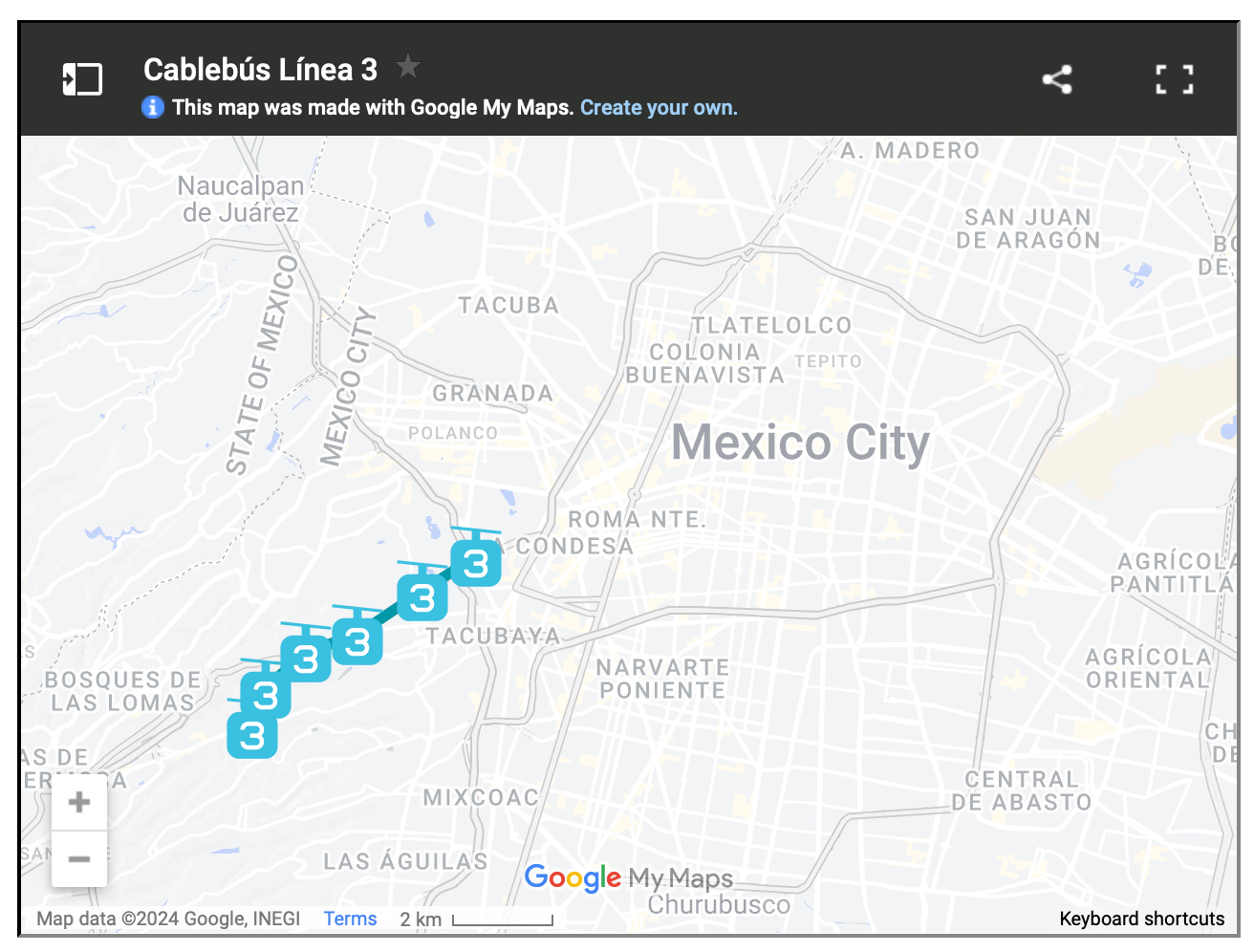
    For reasons like these, Mexico City has spent the last three years building three new cable car lines, the most recent of which opened just last month. The city now has the longest cable car line in the world. But more importantly, it has a new transit add-on that is moving up to 80,000 people per day.

    This isn’t as much as rail. But that’s okay. The point of these lines is to bring more people closer in so that they can then connect to more services and other mobility options. And to do it quickly. Three new lines in three years is impressive. And from the sounds of it, it has transformed many people’s lives for the better.

    Here are maps of the 3 lines, zoomed out a bit so that you can see how they fit into the city’s broader urban context:

  • Shoes follow built form

    I have remarked this before, but I’ll say it again anyways: sneakers are very popular in Paris. Everybody seems to be wearing cool and colorful sneakers, regardless of what the rest of their outfit happens to look like.

    Full business suit? Why yes, you should be wearing cool sneakers.

    But why is that?

    Paris is a famously walkable city. At any given time, you’re on average just about 500m from the closest subway station. So my entirely unproven sneaker theory is this: shoes follow built form.

    If you build a city around people walking everywhere, one will ultimately choose the most appropriate kind of footwear.

    Photo: Rosa Bonheur sur Seine

  • The compactness of Paris

    This is a great diagram from Smart Density comparing the urban and regional rail networks of Toronto, London, and Paris. All are at the same scale.

    What immediately stands out to me — besides Toronto’s relatively miniscule network — is Paris’ compactness. I have said this before on the blog (here, here, and here), but I will say it again: There seems to be a tendency to fetishize the scale and height of Paris.

    But building height is only one component of its ubiquitous built form. Unlike Toronto, we’re not talking about midrises built up against single-family homes. Paris is far more dense and its buildings are far closer together (usually with interior courtyards)

    Are we also okay with these attributes?

  • Toronto breaks ground on new Ontario Line

    This past weekend it was announced that ground has been broken (i.e. construction has started) on the new Ontario subway line that will connect Exhibition / Ontario Place to the Science Centre by way of the light purple line labeled “C” on the above map. (The other image is a rendering of the proposed Exhibition station.)

    This transit line has gone through many permutations over the years and was previously called the Downtown Relief Line (but that was seen as too downtown-centric); the Yonge Relief Line (still too specific); the Relief Line (not Ontario-specific enough, I guess); and probably a bunch of other names corresponding to various lines on a map.

    So it is exceedingly easy to be cynical when you hear of an announcement like this. Is it really happening? Are we actually building new and much-needed transit? And as you might imagine, if you read through the chatter on Twitter, you will find an overabundance of this sort of cynicism, along with what appears to be a general dissatisfaction with the current state of everything.

    But in my simple view, I reckon that it is far better to be starting construction on an important new transit line than not starting construction on an important new transit line. So this is exciting! Let’s go! If you’d like to learn more, I also tweeted out the initial renderings for the 14 stations that are planned for the Ontario Line.

    Images: Province of Ontario

  • Too much low-rise — Theresa O’Donnell in conversation with Larry Beasley

    I attended the above talk last night over Zoom. (Shoutout to Michael Mortensen for inviting Slate’s development team and for helping to moderate the Q&A.) The talk was a conversation between Larry Beasley (former Director of Planning for the City of Vancouver) and Theresa O’Donnell (the newly appointed Director of Planning for the City of Vancouver). Prior to this, Theresa was the director of planning for cities such as Las Vegas, Nevada, and Arlington, Texas.

    I’d like to point out two comments that she made last night that I found interesting.

    The first is that community meetings over Zoom actually aren’t all that bad. And the reason that they’re not all that bad is that they tend to draw out larger crowds (they are easier to attend), and so the feedback on development applications tends to be a bit more inclusive / representative. I agree with this overall view and I’ve been arguing for years (here on the blog) that the typical approach to community engagement is pretty much broken. The opinions become lopsided when you erect too many barriers to participation.

    The second point has to do with the amount of land in Vancouver (and other North American cities) that is dedicated to low-rise housing. It’s too much and it’s going to need to be addressed in order to increase overall housing supply and to chip away at the housing affordability problem. This won’t be news to this audience, but it’s interesting to see how widespread this belief has become. Of course, the big questions remain: How gentle should gentle density be? How much intensification should these neighborhoods see?

    I also appreciated her comment that it’s pure lunacy (my words, not hers) to have higher order transit lines running through mostly low-rise neighborhoods. We need much higher densities to sustainably support these kinds of investments in infrastructure. For us Torontonians, a good example would be (most of) the underdeveloped Bloor-Danforth subway line, though there are other culprits.

    Welcome Theresa.

  • A global survey of urban subway microorganisms

    I don’t think I’m supposed to take any action or feel particularly alarmed after reading about this global mapping of urban subway microorganisms, but it is kind of neat nonetheless. A team of researchers recently spent over 3 years collecting “metagenomic samples” from the transit systems of 60 cities around the world. Everywhere from Stockholm’s handrails to Shanghai’s subway poles.

    The process involved nearly 5,000 samples and the result is this research paper, providing a full atlas of the microbial strains that live throughout our subway systems. Supposedly, none of the findings are anything that we should be worried about though. So carry on riding the subway.

    But it is interesting (and very geeky) to note that the researchers discovered something that they are calling a “core urban microbiome.” What this means is that they identified 31 different species of bacteria that show up in pretty much all of the cities that they surveyed — some 97% of their samples.

    At the same time, each city, because of things like climate and geography, also has its own microbial profile. In fact, these profiles are so distinctive that the geneticist who lead the study is quoted in the New York Times saying that if you gave him a shoe that was a worn in a particular subway system, he could sequence it and tell you the city with 88% accuracy.

    Is this neat or gross?

    Photo by Sergey Zolkin on Unsplash

  • The global effort to build more bike lanes

    I received an email this week from a senior real estate executive who was sharing the fact that, in response to COVID, he had decided to give up driving completely. He was now cycling everywhere — whether for work or for personal errands. And it was doing wonders for his health and his overall well-being.

    Indeed, this feels like some sort of golden era for urban cycling. Back in May I wrote about how Toronto City Council had just approved the largest ever one-year expansion of bike lanes. Some 40 km. When have we ever moved this quickly and without months (okay, years) of painful debate? Probably never.

    Of course, it’s not just Toronto. This is happening all over the world. Here are some of the numbers (taken from this recent Journal article):

    • Paris added 400 miles of pop-up bike lanes across the region — all of which didn’t exist before the pandemic – some of the streets being tracked have seen a doubling in usage
    • Oakland closed almost 10% of its streets to cars
    • Montreal is adding an additional 70 miles of pedestrian and cycle paths
    • Bogota is the midst of planning for 47 miles of temporary bike lanes
    • The UK has fast tracked over $315 million in capital spending for bike infrastructure — referring to this as a “once-in-a-generation” opportunity
    • New York’s bike share service (Citi Bike) saw year-over-year usage surge 67% in the first 10 days of March alone — before any shelter-in-place rules were even imposed

    There are obvious reasons for this rush to build out cycling infrastructure. We’re in the midst of a global health crisis and people are staying away from public transit in big numbers. But I think it’s also important to keep in mind that in many / most cases, there is really no other viable mobility solution. You cannot take all the people that used to ride the tube in London and plop them into cars. There isn’t enough space.

    So cities all around the world are doing the sensible thing and acting fast to make sure that it’s safer for people to move about on bikes. But as we all know, humans tend to have a bias toward the status quo. And so when this is all said and done, I suspect that many of these pop-ups will end up sticking around. And that will be a good thing for cities.

  • New York City is testing new “flex gates”

    I spent a good chunk of this morning talking and thinking about underground building details that most people (unless you’re in the industry) would never think to consider. This is not a criticism on most people. I mean, I don’t know how iPhones are made. I just use and enjoy them. But when it comes to buildings, I’m paid to ask questions and understand how things work.

    There’s a lot of risk in the ground.

    You have to think about things like bearing capacity, environmental contamination (usually), hydrostatic pressure and, generally, how you’re going to manage water, particularly if you have a high groundwater table. Usually this last one is about making sure you’re keeping the water out. A pretty important detail both below and above grade.

    So when I came home tonight and saw the below tweet, I felt obligated to write about it.

    If you read the reply from NYC’s Metropolitan Transportation Authority, you’ll see that this is them testing something they call a “flex gate.” It is a flood barrier that allows them to seal off subway entrances in the case of a storm surge and they run these tests (shown above) for 4 hours at a time to make sure they’re installed property. This one was.

    Managing water is a big part of city building. New York City, Miami, Venice, and countless others know this all too well right now.

  • The Yonge line

    On September 8, 1949, Toronto held a groundbreaking ceremony at the intersection of Yonge & Wellington to celebrate the start of construction for its very first subway line. (Formerly known as the Yonge line, now called line 1.)

    The scene looked like this:

    Some of the buildings in these pictures still remain, but many do not. The first picture is looking north. And the second one is looking south toward the lake. You can see the rail corridor in the background.

    There’s something very urban about these images. The storefronts look active and the streets are full, though no one appears to be live tweeting the event and this clearly pre-dates Toronto’s transformation into the most diverse city in the world.

    But my favorite bit of these photos is the people hanging out on the exit stair, watching the march toward modernity. It’s an image that no longer correlates to Toronto.

    Images: Toronto Archives

  • The capital of the future: Shanghai

    Joe Berridge’s recent opinion piece in the Globe and Mail makes the case for why Shanghai is destined to become “the capital of future.” Brash city building, massive scale, and entrepreneurial hustle are among some of the reasons why he believes the city is on a path to global supremacy. And similar to other great capitals, it has benefited from a strategic geographic position on an important waterway — in this case the Yangtze River.

    By way of comparison, Toronto is said to be the fastest growing urban region in both North America and Europe right now. We add somewhere around 125,000 people each year. Shanghai, on the other hand, is adding between 700,000 and 800,000 people each year — much of it from internal migration. The city currently has a population of around 24 million people and it is expected to grow to somewhere between 35 and 45 million people by 2050. (Figures from the Globe.)

    Notwithstanding all of our successes as a global city region, as I was reading Berridge’s piece I couldn’t help but come back to this comparison. Shanghai opened its first subway line in 1993. Today it has one of the most extensive networks in the world; whereas, it would probably take Toronto this long to figure out if that first line should be light rail or a below-grade subway. And we haven’t even gotten to the number of stops yet.

    But that’s one of the differences between top-down and bottom-up city building: speed.

    Photo by Denys Nevozhai on Unsplash