Daily insights for city builders, delivered every morning at 6 AM ET. I’m Brandon Donnelly — a Toronto-based real estate developer and founder of Globizen. I’ve been writing here since 2013.
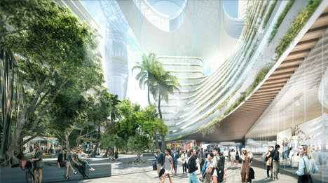
I was browsing through my online reading list this morning (as I do every morning), and I stumbled upon this Dezeen article talking about a big new 6.5 million square foot development being proposed in Miami’s Park West neighborhood.
The goal of the project is to transform Miami into “Florida’s Silicon Valley.”
This sort of thing is happening all around the world. From Buffalo to Lisbon, cities everywhere are betting on tech, startups, and entrepreneurship to grow their economy in the 21st century. And I personally think that’s really exciting.
But as I was reading the article, I couldn’t help but think of an old essay that Paul Graham wrote back in 2006 called, How to be Silicon Valley. (Paul Graham is a famous Silicon Valley entrepreneur/investor).
In his essay Graham argues that to be or to replicate the model of Silicon Valley in your city, you basically need two types of people: rich people and nerds. The idea, of course, being that the nerds work on the cool new ideas and the rich people then fund them.
Using this logic, he specifically calls out Miami as a city where few startups happen and as a city not likely to become another Silicon Valley. Though there’s lots of money and rich people in Miami, there simply aren’t enough nerds. In Graham’s words: “It’s not the kind of place nerds like.”
But that was back in 2006.
The iPhone didn’t even exist yet. Things have since changed. Now there are successful tech companies like Snapchat (valuation north of $15 billion) that are based out of cities like Los Angeles. And I think you could argue that Los Angeles and Miami do share some similarities.
So while it may have seemed far fetched in 2006 for Miami to become a startup hub, is that really the case today?
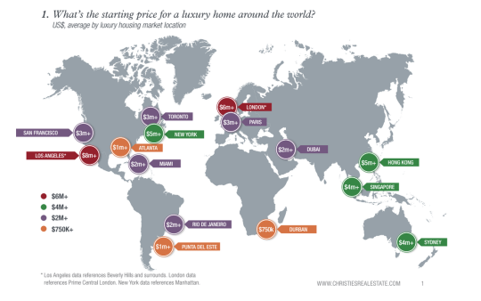
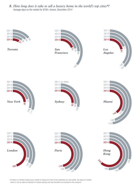
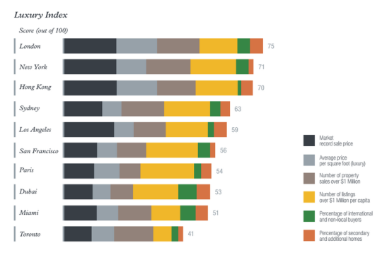
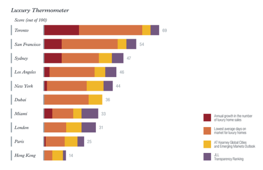
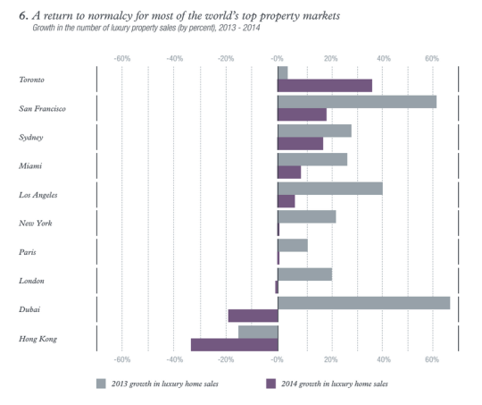
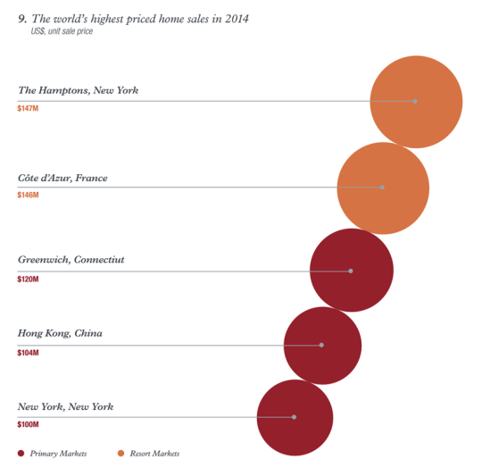
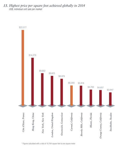
This morning I read through a real estate report called Luxury Defined. It’s a look at the global luxury real estate market across “the world’s top 10 cities for prime property” and about 70 regional and resort destinations.
It’s interesting to look at the trends and see how high-net-worth individuals (HNWIs) are choosing to allocate their funds in residential real estate. Here are some of the charts and diagrams that caught my eye as I was going through it (you may need to zoom your browser in):
If you’d like to download the full report, click here. It’s free, but you’ll need to enter your name and email address.
Last year The Congress for the New Urbanism (CNU), which is based out of Chicago, published a report called, The 2014 Freeways Without Futures. It listed the top 10 freeways across North America that are in need of removal, replacement, and revitalization. You can download the full PDF report by clicking here.
Here’s an introductory snippet from the report:
The 2014 Freeways Without Futures Report lists the top opportunities in North America for replacing aging urban highways with boulevards or avenues that connect to the networks of streets. They are presented in no particular order of rank. As in previous reports, the criteria for the 2014 list is based on a number of factors: the age and design of structures, redevelopment potential, potential cost savings, ability to improve both overall mobility and local access, existence of pending infrastructure decisions, and community support.
And here’s the list of freeways without a future:
I-10/Claiborne Overpass, New Orleans
I-81, Syracuse, New York
Gardiner Expressway, Toronto
Route 5/Skyway, Buffalo
Inner Loop, Rochester New York
I-70, St. Louis
I-280, San Francisco
I-375, Detroit
Terminal Island Freeway, Long Beach
Aetna Viaduct, Hartford
Not surprisingly, the Gardiner Expressway is on the list. CNU is in agreement with the “remove” option currently being contemplated by Toronto City Council and will be doing their part to support the Gardiner East petition that Stephen and I created. Thank you for that 🙂
Break up outdoor spaces with comfort stations (not sure why they just have to be stations)
Design for active winter programming
These, of course, aren’t new design strategies. Cities have been built around their climates since, probably, the beginning of cities. It wasn’t until more recently that we started basically ignoring local climates and focusing more on what mechanical systems can do to make us feel comfortable.
But I think that was a mistake. I don’t think that mechanical systems are bad though. I just think that there’s a lot that we can do first – without mechanical systems – to address local climates.
If you’ve ever sat on a patio during a swing season (i.e. right now) where the wind was blocked and you were in the direct sun, you already know that there’s a lot that can be done without relying on active systems.
But the other thing I like about this post is that it acknowledges the fact that winter waterfronts require just as much, if not more, design attention than a warm-climate waterfront.
Saying that we’ll (insert cold-climate city name here) never be Miami or Barcelona or Sydney is just giving up.
This morning I stumbled upon an interesting Medium article talking about the need for an all-day two-way urban rail service between Toronto and Waterloo.
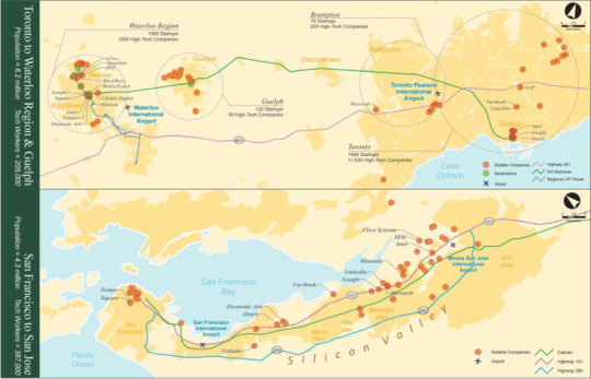
The argument is that along this corridor sits a technology ecosystem that is second in size only to San Francisco-Silicon Valley and that current connectivity levels represent a missed opportunity of epic proportions. Presently this rail service will feed you into Toronto during the morning rush hour and take you back out in the evening rush hour. But that’s it.
According to this report prepared by the City of Kitchener (which is beside Waterloo), efficient train service would stitch together an ecosystem of approximately 12,800 technology companies, 2,800 startups, and 205,000 technology employees. It would also connect 6 universities and 4 colleges, many of which are ranked top in the world.
There’s an argument here that this is exactly the sort of thing that governments should be doing to encourage innovation and entrepreneurship. Rather than trying to be heavily involved in actual startups, they should be creating an environment that maximizes output and then getting out of the way.
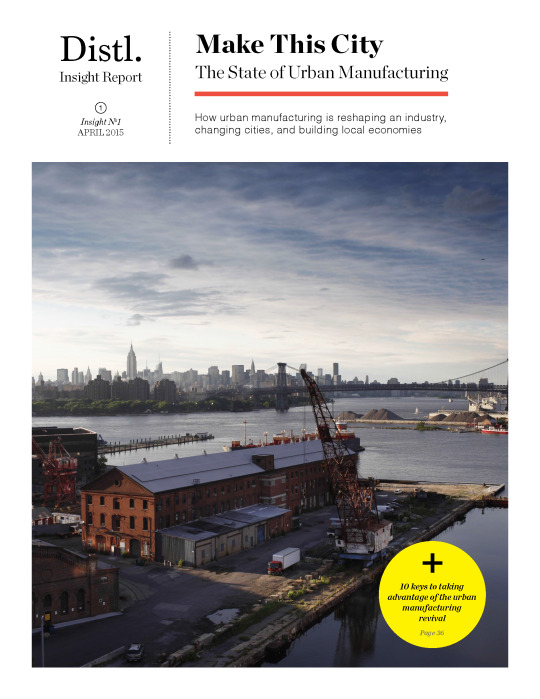
My good friends over at Distl here in Toronto have recently published their first Insight Report. It’s called, Make This City: The State of Urban Manufacturing, and it’s available via free download here. I like the title 😉
The report is 39 pages and is really well put together. There’s research, case studies spanning San Francisco to Toronto, and some great takeaways for city builders.
Since the internet likes listicles, here’s a preview of some of those takeaways – 10 ways that cities can take advantage of the urban manufacturing revival:
Preserve urban industrial areas
Focus on the niche
Public investment is a good investment
Think mixed-use
Diversify learning
Redefine industrial assets
Connect supplier & retailer
Leverage your city’s brand
Form supportive organizations
Leverage partnerships with both the private and public sectors
But it’s definitely worth a complete read and I plan to do exactly that this weekend. Click here to download Make This City.
Today I learned about something new called 2030 Districts. They are: “designated urban areas committed to meeting the energy, water, and transportation emissions reduction targets of the 2030 Challenge for Planning.”
Toronto’s new 2030 District is downtown, which is bound by the lake in the south, Bathurst Street in the west, Dupont Street and Rosedale Valley in the north, and the Don Valley in the east.
It’s the first district outside of the US. The other established districts are in Seattle, Pittsburgh, Los Angeles, Denver, Stamford, San Francisco, and Dallas.
The goals for Toronto’s district are as follows (quoted from 2030 Districts):
To cut district-wide emissions in half, including zero-emissions from new buildings by 2030.
Support a better understanding of where and why energy use, water use, and GHG emissions occur across the District.
Work in partnership with building owners, service providers and conservation groups to accelerate the adoption of best practices for building design and management.
Facilitate broad stakeholder dialogues to uncover and overcome systemic barriers to long term reductions in energy use, water use and GHG emissions.
I’m looking forward to following and learning more about this initiative. I think many of us can agree that producing less, not more, GHG emissions in the future would be preferable. And we know that the bulk of it comes from both buildings and transportation.
Lloyd’s thesis is basically that Ed is wrong in arguing that reducing the barriers to building is the most effective way to maintain housing affordability; that cities are really made out of flesh, rather than bricks and mortar; and that urbanists need to move beyond the view that a city’s past should be preserved at all costs.
Lloyd then goes on to argue that rather than continuing to over-intensify cities like New York, San Francisco, and Toronto, we should be turning our attention to former powerhouses like Buffalo and trying to figure out how to reinvigorate those cities. The bones are already in place.
Now, I don’t disagree that there’s lots of potential in cities such as a Buffalo and Detroit. I’ve written a lot about Detroit and I’m genuinely rooting for the city. But I don’t think it’s as simple as it sounds to shift our attention, and I don’t agree with all of the critiques of Glaeser’s work.
As important as built form is, cities like Buffalo and Detroit remind us that architecture and buildings alone aren’t enough to build a city. There are countless masterpieces – such as Michigan Central Station in Detroit – that regrettably sit abandoned. You need people and communities.
There’s also a snowball effect.
As a city becomes more successful, there’s a natural tendency for more people to want to be there. It’s no different than the network effect experienced by a social network. A social network without people has no value. But the more people you add to it, the more valuable it becomes and the more difficult it becomes to replace.
So it shouldn’t come as any surprise that people will put up with expensive real estate and small apartments just to live in cities like San Francisco. That’s where they want to be. And as long as the demand to live in those cities is increasing, I continue to believe that it makes sense to build more, not less, housing and to make it reasonably easy to do so.
At the same time, I believe whole heartedly in heritage preservation. As a trained architect, there’s a strong possibility that I would shed an actual tear should a building with heritage value be torn down in my city or in any city in the world.
And that’s why when I was on CBC radio last week I said that neighborhood investment needs to be a balance between preservation and progress. The Twittersphere later blasted me for using the term “progress”, but I think you get my position.
My interpretation of Glaeser’s work has never been that he supports completely erasing a city’s past in order to make way for the future. If that is his position, then I too disagree with it.
My interpretation has instead been that he supports removing unreasonable barriers to development so that cities are able to supply – or can at least try to supply – enough housing to meet growing demand. This also doesn’t exclusively mean high-rise intensification. It could mean removing the barriers in front of things like laneway housing. And I continue to believe that this is a good idea.
I don’t believe that this approach alone will solve all housing problems, but I do think it’s a great place to start.
Last Tuesday the app launched in 10 cities across North America. So if you’re in Boston, Chicago, Los Angeles, New York, Portland, Seattle, San Francisco, Toronto, Vancouver, or Washington D.C., you can go ahead and download it right now.
The biggest “wow factor” is probably the augmented reality feature that allows you to hold your phone up and see transit information overlaid on top of the street in front of you.
But more fundamentally, the real potential lies in the platform’s ability to collect data on the way people move in cities and on how transit lines are performing, so that it can be fed back to improve overall efficiency.
That’s why the company is also working with cities to give them 24/7 analytics and reporting on how every bus, car, and train is performing in their networks.
My hope is that with better data at our disposal, we’ll be able to elevate the discussions around transit and transit planning. Without great data, it’s too easy for these discussion to become political.
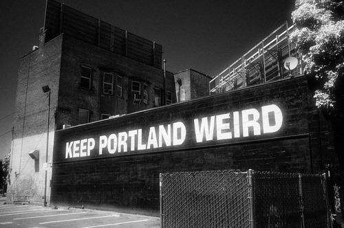
In it he talks about a “weirdness index” that he developed for CEOs for Cities that measured and ranked 50 American cities across 60 different behavioural indicators. San Francisco and Salt Lake City come out as the weirdest, and Portland ranked 11th out of 50. The most “normal” part of the US was the Midwest. Normal meaning behaviours that are most similar to the national average.
He then goes on to talk about weird as a competitive advantage. Here are a few snippets:
When it comes to economic success in today’s economy, the key is to differentiate yourself from your competitors. Harvard Business School’s Michael Porter counsels businesses that “competitive strategy is about being different.” And the late, great urbanist Jane Jacobs told us, “The greatest asset that a city can have is something that’s different from every other place.”
True entrepreneurship is about deviant behavior: starting a business that makes a product that no one else has thought of or thinks there’s a market for. Entrepreneurs and open-minded, experimental customers go hand-in-hand.
We shouldn’t do things just to be different, but we should never be dissuaded from trying something simply because it is different or would make us different from other places.
What this all comes down to is the simple fact that what is weird today, might very well become the norm tomorrow. But you need to be open enough to allow that to happen if you want to be the place that generates those news ideas.
Could you have imagined that selfies would become as ubiquitous as they have? That would have been pretty hard to predict. It used to be the case that people were afraid to use their real name on the internet. Now we share our entire life online, including our faces.