Daily insights for city builders, delivered every morning at 6 AM ET. I’m Brandon Donnelly — a Toronto-based real estate developer and founder of Globizen. I’ve been writing here since 2013.

Tag: public transit

  • Toronto exploring road pricing on downtown highways

    Road pricing is on the table in Toronto. (Somebody has to fund the expensive Gardiner Expressway East rebuild.) On March 11, 2016, the City issued a Request for Proposal for: “Options for Establishment of Toll Facilities on F.G. Gardiner Expressway/Don Valley Parkway.”

    As a vocal supporter of road pricing, I am happy to see us headed in this direction. And I bet that today’s post will just be the beginning of my ruminations on this topic.

    Because naturally, it raises a lot of questions:

    Should the pricing be fixed or variable? Similar to how Uber’s surge pricing model is intended to ensure that there are always enough drivers on the road, should our road pricing model strive to eliminate traffic congestion by increasing the price of the road as demand rises beyond road capacity? I like the idea of a “congestion charge” rather than just a road toll. There’s something very efficient about it.

    Who should pay? Should anyone and everyone who uses the road pay? Or should it just be be non-Toronto residents who aren’t already paying property taxes in the city? I would imagine that this latter scenario would be easier for Toronto politicians to get behind, since there will obviously be a segment of people who flat out don’t want road tolls/pricing. But if we stick with the principle that it’s a “congestion charge”, then everyone should pay. It doesn’t matter where you live when you are demand trying to exceed the available supply of road.

    (I’m running a Twitter poll right now with this exact question. At the time of writing this post, “everyone should pay” is winning.)

    Should electric vehicles be exempt from the road tolls or congestion charges in order to help accelerate our transition away from fossil fuels? With Tesla getting ready to announce its mass market Model 3 (price $35,000), I’ve been thinking lately that the car I currently own may very well be the last gasoline car I ever own.

    It’s still early days for road pricing and our mayor doesn’t seem to be a fan. So who knows how far we’ll get with this RFP. But I for one hope that we find the courage to make the difficult decisions and that this new revenue stream is leveraged for the purpose of building more sustainable forms of urban transport in this city. 

    Let’s make a 50 year decision and not an election cycle decision.

  • Toronto’s rapid transit network by 2031

    Starting today and running until the end of March, the City of Toronto, the Toronto Transit Commission, and Metrolinx will be hosting several public meetings as they work towards planning out this city and region’s rapid transit network.

    Below are a few of the key maps from their presentation.

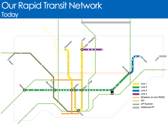
    Here is what Toronto’s rapid transit network looks like today (the hollow lines represent projects in construction):

    image

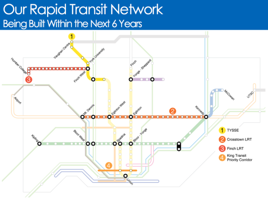
    Here is what will be built within the next 6 years:

    image

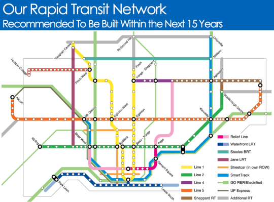
    And here is what they are recommending should be built within the next 15 years:

    image

    It’s hard not to get excited when you see maps like this. Of course, it’s a lot easier to draw lines on a map then it is to fund and execute on projects like this.

    But I think it all starts with us acknowledging that these initiatives are critical to both our economic competitiveness as a city region and our quality of life as citizens of it. Because if this is something we really want, then we can absolutely make it happen.

    Click here if you’d like to see the full presentation and also the public meeting dates/times.

  • Ridesharing could help solve the last mile problem

    X by Keith Mokris on 500px.com

    https://500px.com/embed.js

    A few months ago I wrote a post about Uber’s new “Smart Routes” feature and ended by saying that it’s not just taxis who need to be thinking about platforms like Uber, it’s also public transit authorities.

    I said that because I think that multi-modal is already the new reality in terms of how we get around cities and because the line between different modalities is becoming greyer all the time.

    That’s why I was interested when I stumbled upon this NextCity article talking about how Lyft is starting – it’s still early days – to collaborate with transit authorities in order to make it easier for people to switch between public transit and its peer-to-peer ridesharing marketplace.

    Why might this matter? Here’s an excerpt from the article:

    “According to the company’s data, 25 percent of Lyft riders say they use the service to connect to public transit. In Boston, 33 percent of those rides start or end near a T station. And transit hubs like Chicago’s Union Station, D.C.‘s Union Station and Boston’s South Station are among the most popular destinations for its users, Lyft finds. So riders already see on-demand rides as a solution to the first mile/last mile problem. Lyft thinks it can do more.”

    These last 2 sentences are interesting. Public transit can often suffer from what is known as the first mile/last mile problem. This is a problem where riders find it difficult to get to the nearest transit route from their departing point or to their ultimate destination once they exit transit.

    Bikesharing can be used to solve this. But, clearly, so can ridesharing.

    The other important aspect of this emerging collaboration is that ridesharing apps can offer a lot of incredibly valuable data to transit authorities. If 25% of users are indeed using it to connect to public transit, then all of a sudden cities are getting a more complete picture of point A to B travel. (Among many other things.)

    But the question in my mind is now, who is going to and who should act as the overall steward in this multi-modal urban mobility network? 

    There are lots of different players involved. Some are public and some are private. But they all play a role in how we are going to continue moving around our cities.

  • Uber, commuting, car ownership, and the future of urban mobility

    Earlier this week I wrote a “Tech Tuesday” post talking about Uber’s new Smart Routes functionality, which it is currently testing out in San Francisco. At the end of the post I ended by saying that it’s not just the taxi industry that should be thinking about Uber, it’s also public transit authorities. 

    And that’s because many people in cities rely on multi-modal forms of transportation (I know I do) and in my mind it is clear that Uber is trending away from just “Everyone’s Private Driver” to a service that is starting to look and feel a lot like urban mass transit.

    Then today my good friend Evgeny sent me a post called, “Public Transit Should Be Uber’s New Best Friend.” And it’s one of the best pieces I’ve read on Uber and its impact on urban mobility. I highly recommend you give it a read, particularly if you’re in the city building arena.

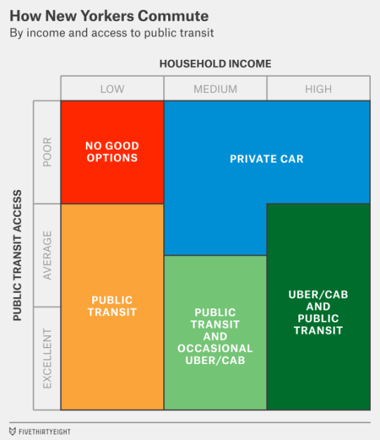
    The article does a deep dive into how New Yorkers commute. Here’s how they broke it down.

    image

    It then talks about what it will take for a company like Uber to make a meaningful dent in car ownership (which is one of the company’s goals) and how the truly big opportunity for Uber is to go more mass market and tap into the public transit market – either by interfacing with or by building its own version of it.

    Here’s their concluding paragraph:

    But there’s a much wider potential audience if Uber can also reach middle-class customers who want to save money. Perhaps in the distant (or even the not-so-distant) future, Uber can build its own version of “public” transit, making rides so cheap that they cost less than the $4 or $5 that Americans now pay, on average, to make a trip in their personal cars. In the meantime, it might have more success among “car-cutting” customers who can use Uber along with public transit. That might mean Uber’s growth is concentrated more in cities like New York, San Francisco and Chicago — and in Europe and Asia — that already have reasonably strong public transit networks.

    It’s definitely worth a full read. Thanks again for sending this over Evgeny.

  • Tech Tuesday: Uber testing out “Smart Routes” in San Francisco

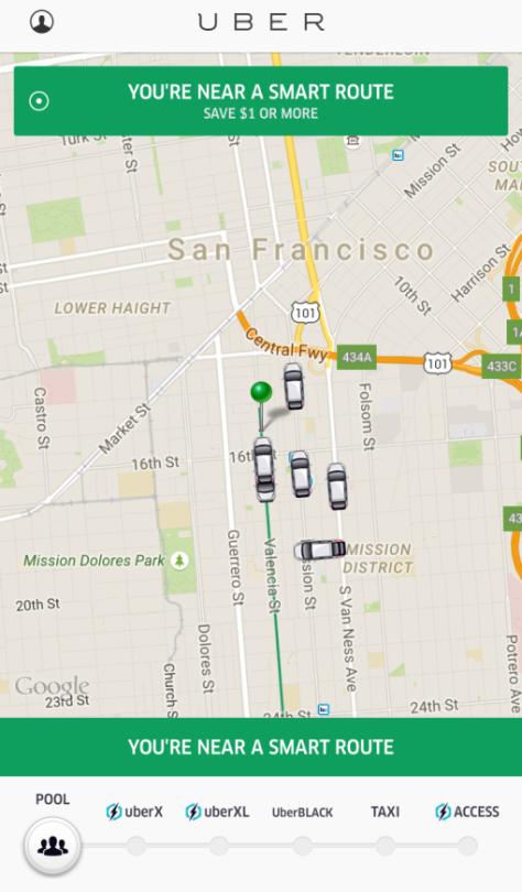
    Uber is currently testing out something called “Smart Routes” in San Francisco.

    Basically it works similar to UberPOOL (where you carpool with strangers to bring the cost down), except that your pickup location (and trip?) is confined to a specific route. 

    This means less detours and more rides for drivers, as well as even cheaper fares for passengers. But just like public transit, you’ll likely have to walk a few minutes to get to the closest route. 

    Here’s a screenshot of what that looks like (via TechCrunch):

    The green line is the “Smart Route.” So all you have to do is select a pickup location somewhere along that green line, and you’ll save a bit a money. Currently it’s “$1 or more” off your fare, but who knows what it might be when this feature actually rolls out.

    This is fascinating to me because it’s starting to look and feel a lot like a conventional bus route. But in this case, the routes can change and new routes can be easily created as demand changes. 

    So it’s not just taxis that need to be thinking about Uber. It’s public transit authorities as well.

  • Guest Post: For whom the road tolls?

    For those of who were following Architect This City during the Gardiner Expressway East debate here in Toronto, you might remember that Darren Davis (transport planner with Auckland Transport) wrote a guest post called, Three minutes that rule the world – Will demolishing the Gardiner East actually make traffic worse?

    It was an incredibly popular post at the time, so I’m thrilled that Darren volunteered to do another one on road tolls. This is a topic that I’m very interested in and have written about a few times. Road pricing, as you’ll see below, puts us in a bit of a chicken-and-egg situation. But sooner or later I think we will need to get our head around it, as will many other cities.

    I hope you enjoy today’s post. Thanks again Darren.

    ——————————-

    A recent post on Architect This City, The Tragedy of the Commons, raised a fundamental but all too often forgotten point about transportation: That in networks where the price of use doesn’t change when demand changes, there is no effective mechanism to manage that demand.

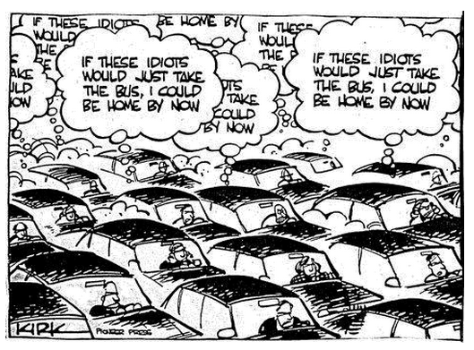
    Because there is no incentive to act in the public good, we often act in what we perceive to be our own personal interest, which is often the antithesis of the public interest. And remember that if we are driving, we are traffic. So often people will sit fuming in their cars in the midst of congestion with thoughts like in this cartoon. But of course with unpriced roads, there is no real price signal to these drivers to consider taking the bus.
    In a world where time is money, we are constantly berated about the economic costs of congestion. In 2011, the Toronto Board of Trade estimated that congestion in the Toronto region alone cost the regional economy $6 billion a year, rising to an estimated $15 billion in 2031 should no action be taken. More recent research by the CD Howe Institute pegs this figure at up to $11 billion.

    Given these sorts of eye-watering figures, one might be tempted to think that car drivers, and in particular the goods industry, would be flinging their wallets open at the chance to buy their way out of congestion. And in fact Toronto has the 407 Express Toll Route which has elements of variable road pricing. However, while the 407 ETR carries around 350,000 vehicles per day, price increases have been matters of controversy. It provides some ability for those who can afford it to bypass Toronto’s notorious traffic congestion, but its fundamental weakness is that it’s just one road in one of North America’s largest city-regions.

    Similar stand-alone efforts to address congestion in Metro Vancouver with tolled routes, such as the Port Mann Bridge on the Trans-Canada Highway and the Golden Ears Bridge, have fallen well short of their projected traffic volumes, while nearby untolled bridges such as the Patullo Bridge are heavily congested. We have a similar experience in New Zealand where our two tolls roads, with car tolls of $2 and $2.20 respectively, experience diversion rates of up to 30% to the alternative but substantially longer and slower free routes.

    This brings up a fundamental paradox: Congestion costs the economy a fortune and congestion is a top-of-mind frustration, yet people seem reluctant to pay even comparatively small amounts to bypass congestion.

    For example, the City of Toronto’s Roundtable on Gridlock & Traffic Congestion in February 2014 came up with the usual shopping list of “transportation systems management” responses – improved management of curbside space and construction projects; synchronized traffic signal phasing; better traveller information and improved incident response. While these are all worthwhile responses, they only improve system operation at the margins. Encouraging greater use of public transit was the very last recommendation and there was not a single mention of charging or pricing as a tool to address congestion. And the feverish activity continues with a hackathon called TrafficJam on October 2 – 4, 2015 with the goal of fixing Toronto’s traffic woes.
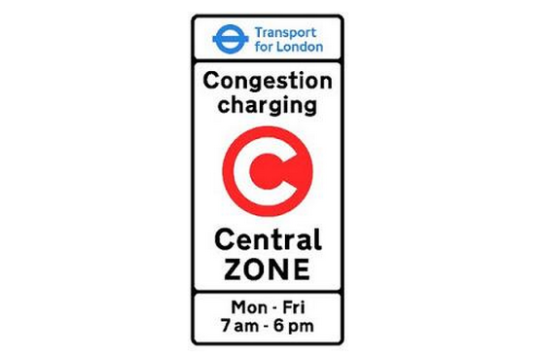
    The very few cities that have actually had significant success at reducing traffic congestion – notably Singapore, London and Stockholm – have done this through cordon-based congestion pricing wherein if you pass the cordon, you pay the congestion charge. Entering central London on a weekday between 7am and 6pm will set you back a cool £11.50 ($C23.30). From 2003 to 2013, about £1.2 billion ($C2.42 billion) of congestion charge revenue has been invested in public transport, road and bridge improvements and walking and cycling, of which £960 million ($C1.94 billion) was for bus improvements. These measures have included significant road space reallocation to improve conditions for pedestrians, cyclists, public transit and the urban realm.

    The latest Travel in London report states that “Over the 10-year period from 2003, total trips have increased by 11.4 per cent, with particularly notable increases of 52.3 per cent in rail trips and 32.0 per cent in Underground and DLR [Docklands Light Railway] trips, with cycle trips (as main mode) increasing by 53.9 per cent. Car driver trips decreased by 12.7 per cent over the same period” (my emphasis).

    One interesting insight is that Stockholm trialed congestion charging and then reverted to business as usual of unpriced roads in advance of a referendum on congestion pricing. This gave Stockholmers a clear sense of the difference in traffic congestion and was crucial in supporting a yes vote in the referendum.

    Stockholm has experienced a permanent reduction in traffic of about 20% across the toll cordon and congestion decreased by 30 – 50% – which demonstrates that traffic volume reductions have a disproportionately positive impact on congestion. About half of the “disappearing” drivers changed to transit, the rest to other alternatives such as different departure times and destinations and taking fewer trips.

    For more on Stockholm, I suggest reading the Tools of Change case study on Stockholm Congestion Pricing.
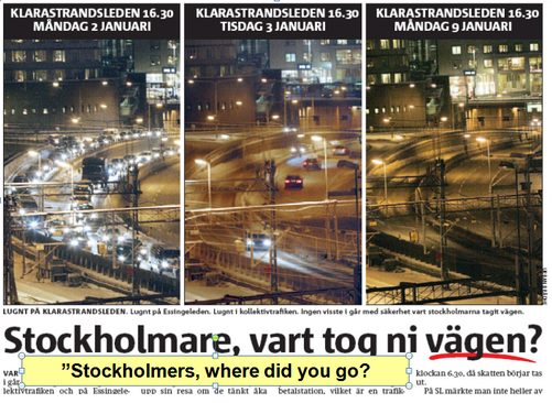
    Before and after congestion charge photos of traffic levels in Stockholm

    While this sounds very promising, congestion charging has significant equity implications and requires upfront investment to provide people who either choose to or can no longer afford to drive with transportation alternatives. Both Stockholm and London invested very heavily in public transit in advance of implementing congestion charging.

    And this brings up a big issue for Toronto. 

    For congestion charging to have a meaningful impact on congestion without stifling economic activity or impeding people’s ability to move around, the core capacity of Toronto’s transit system would need to be addressed first. In particular the Yonge Line capacity enhancements, Metrolinx’s Regional Express Rail and most likely the Downtown Relief Line would need to be in place to provide both capacity and choice for people who either needed or wanted a travel alternative to any congestion charge.  This would mean that Metrolinx’s Big Move might need to get even bigger.

    Disclaimer: The author of the above post is an employee of Auckland Transport, however, the views, or opinions expressed in this post are personal to the author and do not necessarily represent the views of Auckland Transport, its management or employees. Auckland Transport is not responsible for, and disclaims any and all liability for the content of the article.

  • Guest Post: Three minutes that rule the world – Will demolishing the Gardiner East actually make traffic worse?

    Today on Architect This City, we have a guest post by Darren Davis, who is a transport planner in Auckland, New Zealand. He’s a regular commenter on this blog, and I know he’s been following the Gardiner East debate quite closely – as many urbanists around the world are. I appreciate him offering and taking the time to write this piece. Thank you.

    ——————————–

    The decision this month on whether to demolish the Gardiner East Expressway and replace it with a surface boulevard or to rebuild it with a similar elevated structure will be a watershed moment for Toronto, akin to the decision not to have freeways in the urban core of Vancouver in the late 1970s.

    There are numerous good reasons why removing the Gardiner East elevated structure is the right move for Toronto, covered previously by The Globe and Mail and in the Council for Canadian Urbanism’s open letter to Toronto City Council. If you aren’t aware of these, I strongly recommend reading them. 

    Also of note are two things:

    1. Just 3% of Downtown commuters drive on the Gardiner Expressway East, a tiny fraction of the 68% who arrive Downtown on public transit.
    2. The “remove” option does not reduce traffic capacity over the “hybrid” option but could reduce travel speeds in uncongested conditions (read on for why I don’t think that this will happen in real life).

    However, one element of this debate that has not got much airtime is the transportation modelling that claims an additional two to three minutes travel time with the “remove” option over the “hybrid” option which retains the elevated expressway in a slightly modified form. 

    Toronto Mayor John Tory has stated that "I didn’t get elected to make traffic worse. And let’s be clear, removing that piece of the Gardiner will almost certainly make traffic worse.” But is it in fact true that demolishing the Gardiner Expressway East will make traffic worse as the transportation modelling claims?

    The key thing to understand is that transportation modelling, which tries to predict future travel times, is the product of a bunch of assumptions which may not in fact be borne out in real life. 

    For example, the effect of induced traffic, where additional traffic capacity leads to additional traffic being attracted to the route, is reasonably well known but generally not factored into transportation modelling. Induced traffic happens because increased travel speeds attracts traffic that would have otherwise avoided the route at congested times; attracts people to drive where they previously used other modes and encourages trips that would not otherwise have taken place. The effect of induced traffic is to quickly nullify the benefits of adding traffic capacity.

    However, what is less well known is that the reverse happens where there is either a reduction in traffic capacity (not the case in Toronto as the “remove” option retains the same traffic capacity) or speed.

    This is because in this situation, four things happen:

    1. Some travel re-routes. The “remove” option with a widened Lakeshore Boulevard as part of the street grid simply gives more ability for traffic to re-route away from congestion over an elevated expressway structure where drivers are literally trapped until they reach their exit.
    2. Some travel re-times. Some people will retime trips to avoid congested travel times, such as starting and/or finishing work at less congested times.
    3. Some travel changes mode. Some people will be encouraged to change mode by the perceived worsening in traffic conditions.
    4. Some travel is avoided entirely. Some people will choose not to travel at all in the peak of the peak. For example, this could take the form of working from home or shopping on the internet instead of by car.

    Transportation models only take into account the first item but not the others. The modelling is also sensitive to traffic growth assumptions and assumed mode split and trip distribution. Often transportation models assume continued growth in car travel even though per capita kilometres travelled peaked about a decade ago.

    While this may all sound well and good theory, does this actually happen in practice?

    In Auckland city centre, we have extensive experience with the reallocation of road space away from general traffic. Many busy key city centre approach routes have had general vehicle lanes reduced to make way for bus lanes (which generally carry around 65-70% of the people moving capacity of the street). 

    This has involved up to a 50% reduction in private vehicle capacity (whereas in Toronto, the “remove” option retains the same traffic capacity but may slow throughput). Auckland has done two of these in the past twelve months – both involved converting a general traffic lane to a bus lane. 

    Don’t get me wrong: There is sometimes pain at implementation with about a three week period of congestion as car drivers adapt to the new reality – and most likely negative media coverage will accompany this. But after about a month, equilibrium will be restored and life will continue much as it did prior to the change. 

    Part of this is that there will be various “optimisations” during this introductory period where signal timings are adjusted and other tweaks made – the sort of tweaks that can only be fine-tuned in a real world situation. But a bigger part of this is that the four factors above – re–routing, re-timing, mode change and avoided travel – come into play.

    I cannot overemphasise enough that life will return to normal surprisingly soon if the Gardiner East Expressway is demolished and replaced by a widened Lakeshore Boulevard.

    My advice

    When people talk about two to three minutes of extra travel time, take the foregoing into account and take those claims with the very big grains of salt that they deserve. If Toronto makes the right choice and chooses the “remove” option, my bet is that the biggest surprise of all will be how little difference it makes to peak travel times for the 3% of Downtown commuters who used to use the Gardiner Expressway East.

    Disclaimer

    The author of the above post is an employee of Auckland Transport, however, the views, or opinions expressed in this post are personal to the author and do not necessarily represent the views of Auckland Transport, its management or employees. Auckland Transport is not responsible for, and disclaims any and all liability for the content of the article.
  • The case for planning transit around minimum population densities

    Photograph Blitz by Tristan O'Tierney on 500px

    Blitz by Tristan O’Tierney on 500px

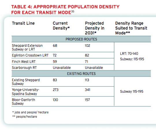
    Back in 2011, the The Pembina Institute published a report called, Building transit where we need it. And in it they quite clearly outlined the population densities that are needed to make various types of transit investment cost effective.

    For subway they specify a minimum population density of 115 people per hectare and for light rail (LRT) they specify a minimum population density of 70 people per hectare. 

    And the reason for this is because there’s a strong correlation between population density (i.e. land use) and transit ridership. The two go hand in hand and should not be decoupled. If population densities are too low (as they are, for example, along the Sheppard subway line here in Toronto), people don’t take transit. They drive.

    Here’s a chart from the report showing the current and projected population densities for Toronto’s existing and proposed routes (keep in mind this is from 2011).

    image

    So what does this chart tell us?

    • Subways don’t make a lot of sense in many parts of the city. LRT will do just fine.
    • The Sheppard subway line is an under-utilized asset. Even by 2031 we’ll barely be reaching the requisite population densities.
    • The Bloor-Danforth corridor could use more intensification.
    • The Yonge-University-Spadina line is going to need to relief.

    Unfortunately, transit decisions are often made based on politics instead of data. And that results in subways in places that don’t make a lot of sense. That’s unfortunate because it means less riders, less revenue, and more subsidies.

    The other challenge with running subways through low density neighborhoods is that it then creates tension when the city and developers go to intensify those neighborhoods through transit-oriented development. (See #DensityCreep.)

    But if we’re going to be fiscally irresponsible about where we deploy our transit capital, the least we could do is upzone the surrounding areas and impose minimum population densities. 

    In fact, here’s what I think we should do: Land use should be bundled with the transit decision. 

    Instead of asking where the subway station should go, we should be asking where the subway station should go and all the density needed to bring the area up to a certain minimum population density. And if that second criteria for whatever reason can’t be met, then we don’t build the line. 

    I wonder if we framed the question in this way if it would change where subway lines get approved. What do you think?

  • What will driverless electric cars mean for cities?

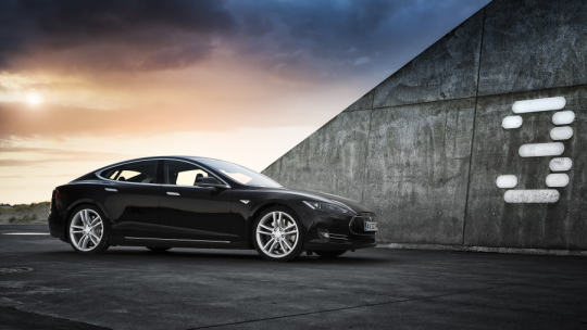
    Photograph T E S L A by Thomas Juel on 500px

    T E S L A by Thomas Juel on 500px

    Yesterday I posted a video about the career of Elon Musk. And it reminded me of something that’s been on my mind as I think about transportation, cities, and the future.

    Elon’s story for why he founded SolarCity, Tesla, and SpaceX is incredibly compelling. He chose problems and industries that he felt would move humanity forward. He felt that we needed sustainable forms of energy production (SolarCity), sustainable forms of transport (Tesla), and a way for humans to occupy other planets (SpaceX). That’s incredible ambition.

    Today though, I just want to focus on the transportation piece.

    Electric and driverless vehicles, I believe, are a step in the right direction. I honestly believe that at some point in the not too distant future we’re going to look back at that time when people used to drive their own cars and wonder how we ever allowed that to happen.

    But fundamentally, I think there still remains a question of how best to plan our cities. 

    There’s lots of talk today about peak car and the death of the automobile. Certainly within planning and urbanist circles, there’s an almost universal belief that planning (most of) our cities around the car, as opposed to people, was a huge mistake. Multimodal solutions with a public transit backbone are now the way forward.

    But will that always be the case as the notion of the “car” evolves?

    Intuitively, driverless vehicles feels like a massive opportunity to leverage data and better optimize our private transport assets. We know that the utilization rate for most private cars is incredibly low and so there’s lots of room to improve how we use and share private vehicles and how we move people around cities.

    But how big is that opportunity? Does a city filled with driverless electric vehicles and with networks like Uber mean that public transportation now becomes less important? And if so, how much less important?

    I can’t help but feel like private and public transport are on a collision course right now. I suppose that isn’t anything new. But this time around I wonder if private transport won’t figure out a way to achieve similar efficiencies to large scale public transport.

  • Where should Toronto’s relief subway line go?

    Those of you from Toronto might be aware that the city is currently assessing the possibility of a “relief subway line” that would connect the downtown core back up to the Bloor-Danforth subway line in the form of a stretched out “U”.

    The reason this line is being called a “relief line” is that – in addition to providing local service all across downtown and its “shoulders” – it would also relieve much of the pressure that the Yonge-Bloor interchange is facing today. Instead of always having to connect at that location, passengers coming from the east and west would be able to do so sooner as a result of this new subway line (bypassing Yonge-Bloor).

    For those of you who are regular readers of ATC, you might know that I’m a big supporter of this relief line. I believe it should be our number one transit priority. It’s going to cut through areas of the city that have some of the highest population and employment densities, and so it’s an area where I think subway makes sense. The ridership would be there.

    Many people at the city also seem to agree:

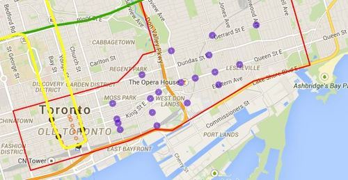
    Given that an assessment is currently underway, the city is looking for feedback from the public. One of the ways you can do that is by clicking here. The site will allow you to comment on the potential station locations (shown below using purple circles). I did it this morning and I would encourage you to do the same if you’re from Toronto.

    For clarity, this current study is only for the eastern portion of the relief line (study area is outlined in red below).

    image

    Once you’ve given this some thought, I’d love to have a discussion in the comments about where you think the relief subway line should go (or if you even think it’s a good idea in the first place).

    My initial thought is that it should connect into King station, run along King Street East, merge with Queen Street East near the Don Valley, go through Riverside and Leslieville, and then start making its way north to Danforth Avenue.

    My reasons are as follows:

    • King Street East is the most vibrant pedestrian street on the east side of downtown. There isn’t enough commercial activity further south.
    • King Street would allow it to eventually cut right through the Financial District when it heads westward.
    • The connection to Union station (for GO Transit, VIA Rail, and the Union-Pearson Express Train) would be manageable from King Street. Plus, SmartTrack may feed directly into Union.
    • King Street is roughly the midpoint between Queen Street and Lakeshore Boulevard. And if you place it too far south, it would take away from the proposed Queen’s Quay LRT line.
    • Having it merge into Queen Street near the Don Valley would allow it to service both Regent Park to the north, as well as the West Don Lands neighborhood to the south. It would also allow for a connection to a Cherry Street LRT line servicing the future Portlands neighborhood.
    • Queen & Broadview is emerging as a major node with a significant amount of density in the pipeline. And further north, Dundas & Carlaw is similarly seeing a lot of intensification.

    But I may have missed a few things. These are just my thoughts. What are yours?