Daily insights for city builders, delivered every morning at 6 AM ET. I’m Brandon Donnelly — a Toronto-based real estate developer and founder of Globizen. I’ve been writing here since 2013.
I’ve written quite a bit about the advantages of a “rail + property” model when it comes to building public transit. It’s a model that works quite successfully in other parts of the world, such as in Hong Kong.
However, in North America the notion of land value recapture or of transit authorities acting as real estate developers is still very much in its infancy. We’re myopically focused on rail.
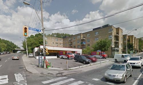
Which is why I said about 3 months ago that if the stations along the new Eglinton Crosstown LRT line in midtown Toronto became single storey and single purpose buildings, that we will have missed an enormous city building opportunity.
Since that post I had a number of conversations with the folks over at Metrolinx and I was delighted to learn that there were in fact plans to build additional density on top of the stations. And as of today they’ve gone completely public with that intention.
Metrolinx, with the help of Avison Young, has just issued a request for proposal (RFP) for 4 sites along Eglinton Avenue in the city. Two of them are at Keele Street, one of them is at Weston Road, and the last one is at Bathurst Street. The 4 sites could generate between $14M – $22M.
The objective is to find suitable developer partners to help them build on top of their planned LRT stations. And it’s a step in exactly the right direction for Metrolinx and this city.
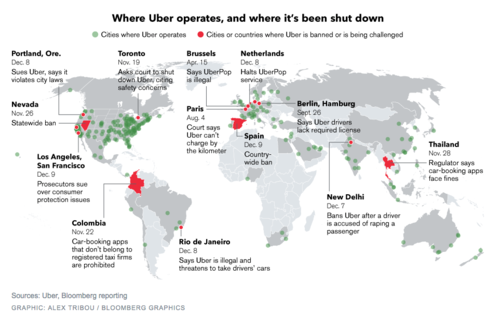
Earlier this month, Bloomberg published this map showing where Uber operates and where it’s been banned (or is being challenged). You can click on the map for a larger version.
Uber operates in about 250 cities across the world. But it’s being challenged in a lot of them, including Portland, San Francisco, Los Angeles, Toronto, Rio de Janeiro, Paris, Berlin, as well as others.
I don’t want to dismiss any of the safety concerns that have arisen lately, because those are very serious and they need to be addressed. Life safety is paramount. But I continue to believe that banning a service that many people clearly want to use isn’t the right solution.
On top of that, I think it could lull many of the local taxi communities into a false sense of security about the future. Uber is moving incredibly quickly. UberX launched in Toronto in September of this year. And UberPOOL – their new carpool service – is likely next.
With these releases, Uber is working towards a specific vision for the future: Their goal is to eliminate the need for private vehicle ownership. Should they be successful, this will not only impact taxis, but also car manufacturers and urban mobility in its entirety.
So as difficult as it might seem right now, I think urban leaders would be better served trying to figure out how to harness these innovations. Cities have been trying for decades to get people out of their cars. Uber wants to do the same.
If you’ve been reading Architect This City since last winter, you might know that every year I go on one big snowboard trip with a group of guys I went to grad school with at Penn. Last year we went to Jackson Hole and Vail, and this year the plan is to go to Banff and Revelstoke.
We start planning it by the fall and so already we’ve been trying to sort out the details for this winter’s trip. But as we finalize the plans, one thing I’ve noticed is how I’ve automatically been trying to minimize the amount of driving that we’ll need to do. In fact, in a perfect world, we wouldn’t have to rent a car at all.
Now, small mountain towns aren’t usually the best for public transit, but there are often ways to get around that. When we were in Jackson, we took the public bus to get to the mountain every day, as did most people who lived or stayed in town.
This winter, the plan is to fly into Calgary and stay in Banff for the first leg of the trip. So I’ve been trying to figure out if there’s a train that can get us from Calgary to Banff and which hotels offer shuttle buses to the mountains. Because I’d rather not drive, and I know many of my friends feel the same way. It’s an added cost and it gets in the way of après ski.
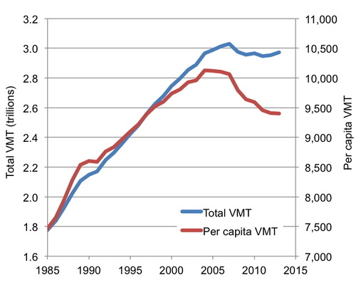
What’s interesting about this, is that not only do I try and minimize the amount of driving I do here in Toronto, but I do it when I travel as well. And if you’ve been following the macro trends, you might know that many other people feel the same way. That’s why total Vehicle Miles Traveled in the US has been in falling since about the mid-2000s:
People are falling out of love with driving, and many believe that this shift is permanent. Here’s a recent report from the US PIRG Education Fund talking about just that:
I also think this shift is permanent – until maybe the nature of driving changes and cars start driving themselves. But at that point, it won’t be called driving anymore and there will probably be many other changes. So on this rainy Wednesday morning, my big bold prediction is that future generations will no longer drive.
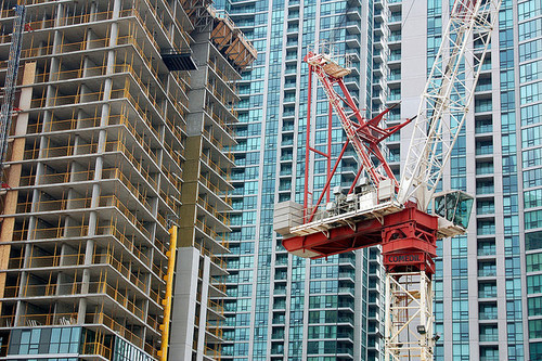
Earlier this week, Toronto City Council approved the equivalent of 755 storeys of new development, a lot of which will end up in the downtown core. The translates into 6,887 new housing units and roughly 4 million square feet of new commercial space. The Globe and Mail called it the Manhattanization of downtown.
If you’d like to go through the complete City Council meeting agenda, you can do that here. (I warn you though, it won’t be an exciting read.)
One notable project that was approved is 50 Bloor Street West, which is a 71-storey mixed-use building in Yorkville adjacent to and on top of Holt Renfrew (It includes a $6 million Section 37 contribution). I mention this one because it’s impressively tall and because it’s a project that I was involved with when I was at Morguard. Watch for Yorkville in the coming years, there’s a lot in the pipeline.
While I think this is all incredibly exciting, our chief planner, Jennifer Keesmaat, is entirely correct in pointing out that all of this highlights the desperate need for better infrastructure, the most critical of which is a relief subway line that cuts across downtown.
But to be clear, this isn’t a question of just planning for growth. This is a question of planning for growth and making up for decades of infrastructure disinvestment. That’s the position we’re in today, which means we have a lot of hard work to do. Though I’m confident we’ll get it done.
The other thing that this level of intensification should highlight for you is that public transit, and other forms of mobility such as biking and car sharing, have to be central to our goals. It’s simply infeasible for everybody to be driving around in a car. We’re currently demonstrating how efficient that ends up being.
One of the things that many city planners, transportation experts, and municipalities are trying to figure out is how to successfully shift people away from driving towards alternative modes of transportation, such as biking and transit. Now, this is no easy task. There are a myriad of factors that influence a person’s decision to drive or not drive–or if they should even own a car in the first place. Though, land use and density are, in my opinion, probably the biggest.
But of all the solutions thrown around, mobile apps are typically not within the playbook. However a recent New York Times article is making the argument that it should be, because car-sharing services and apps like Uber seem to be indeed having an affect on people’s decision to own a car. And that’s because in some cities it’s actually cheaper to use Uber every day (than to own a car) and because taxi use has been shown to correlate with other (non-driving) forms of mobility.
Paradoxically, some experts say, the increased use of ride-sharing services could also spawn renewed interest in and funding for public transportation, because people generally use taxis in conjunction with many other forms of transportation.
In other words, if Uber and its ride-sharing competitors succeed, it wouldn’t be a stretch to see many small and midsize cities become transportation nirvanas on the order of Manhattan — places where forgoing car ownership isn’t just an outré lifestyle choice, but the preferred way to live.
And to be honest, I don’t think this is all that far stretched. More and more I find myself wondering why I even own a car. It’s not appreciating sitting downstairs in my garage and, given the frequency in which I use it, I would definitely be better off financially if I simply used an app like Uber or Hailo more often. About the only thing those apps aren’t great for are trips to Home Depot and snowboard trips to the mountain.
I’m a big believer in public transportation. I generally believe that the only way to build a big, efficient, and sustainable city is on the backbone of a good transit system. But at the same time, I’m open to fresh ideas. And I’m concerned with the inability of most cities to actually build transit in a way that meaningfully responds to demand.
So what are the alternatives?
The first thought that comes to mind is the delivery system itself. Some cities, such as Hong Kong, have successfully combined transit delivery with real estate development as a way to improve the economics behind building transit. And I think that makes a lot of sense.
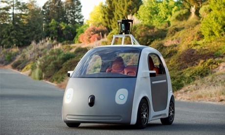
But my other thought is that maybe the solution to urban mobility is something completely new. Maybe Google is on to something with their driverless cars. Is that the future? Many would disagree.
We’ve established that cars don’t work all that well for getting people around in big congested cities. So what difference would it make whether or not the cars have a driver or not? Well, I was thinking about this last night and there are some meaningful differences.
A network of driverless cars would give us perfect information about all to the cars on the road. Similar to to how Google’s Waze navigation app feeds off user input (both active and passive), we’d know the exact number of cars on the road and the precise point in which additional cars would cause a drop in efficiency (i.e. a reduction in vehicle speeds).
At the same time, it could enable a powerful sharing economy. In a recent study done by MIT’s Senseable City Lab, it was found that roughly 80% of New York cab rides could be shared. That is, 80% of the time there’s somebody else who’s also traveling from roughly the same point A to the same point B.
So here’s what I’m thinking.
You use Google’s driverless car technology and the perfect information you get from the networked vehicles to create a fluid and ever-evolving transit network. What I’m imagining is that the driverless vehicles don’t operate based on a model of individual mobility; they instead operate on a principle of batched mobility.
Let’s say for example that there are critical mass of people who want to leave Liberty Village between 8:00am – 8:30am to travel to the Financial District. What they would do is enter this itinerary and then a “station” would get formed somewhere nearby. Users would get notified of the station’s location, which would be determined based on proximity to the highest concentration of “riders.”
The driverless cars would then get notified and would begin assembling the appropriate number of vehicles at the selected station location. As is the case with conventional forms of public transportation, most people would need to walk to the station. But never that far.
In essence, it would function as a cross between private and public transportation. You would get the economies of scale generated by public transit, with some of the individual conveniences of private transportation.
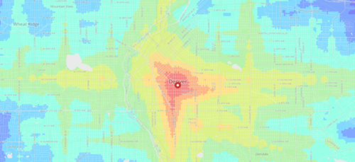
The app allows you to click on a location within one of these cities (or enter an address) and then receive a visual representation of travel times from that location.
Both public transit and walking are factored in, and the fastest of the two is then modeled. The public transit data is taken from each respective authority and is similar to the data used by Google Maps.
With these sorts of applications, I always wonder what it might look like overlaid with additional data points, such as home prices. Intuitively I would expect the best connected neighborhoods to also have some of the highest real estate values.