Daily insights for city builders, delivered every morning at 6 AM ET. I’m Brandon Donnelly — a Toronto-based real estate developer and founder of Globizen. I’ve been writing here since 2013.
It felt like a frenetic year for me, and so I have to say that I’ve been really enjoying this holiday break. I needed the downtime. I needed the time to think and strategize. And I got all of that this holiday. (The only thing that would make this break even better would be some more snow on the mountains.)
I’m super excited for the new year and what’s ahead, but before getting into that, I thought it would be worthwhile to look back at what happened in 2014.
I was initially going to list out some of my thoughts, but then I figured that a better way would be to simply list out the most read Architect This City posts. That way it’s my (daily) thoughts, but curated according to what readers cared about most this past year.
A few years ago, I was touring a friend from the US around Toronto’s Financial District and the first thing he said to me was: “You have no retail.” And that’s certainly what it might look like at first glance.
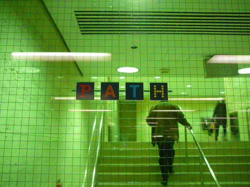
But there’s actually lots of retail. It’s just all underground in an over 30 kilometer long network of walkways called the PATH.
Initially conceived of as the antidote to Canadian winters, “underground cities” are a kind of uniquely Canadian form of urbanism. Toronto and Montreal have the largest ones in the world and they continue to grow. As new towers are built, new connections are added.
But the downside to all of this is that it pulls street life down underground. And it can conceal a lot of the urban vibrancy that is actually take place. So maybe we need to come up with design solutions to better connect these subterranean cities back to street level and also not forget about the street.
I’m thinking about this today because of a CBC documentary I watched this morning called Life Below Zero. It basically argues that – unlike other cold climate cities and countries – the vast majority of Canadians actually hate winter. And underground cities are our way of trying to ignore it.
Well, I don’t hate winter. In fact, I love it because it signals snowboarding season for me. But I may be in the minority. What’s your position on winter?
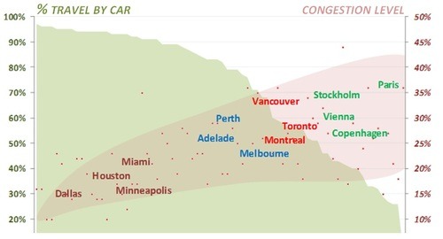
It came from a study that looked at 74 cities in terms of two measures: the percentage of people that travel by car and the traffic congestion levels within those cities.
The way to read the chart is to first look at the red dots. Each dot represents one of the cities studied. The position of the red dot corresponds to that city’s congestion levels. So for example, if we were to take Toronto, the congestion level is 27%.
If you then take that same dot and draw a vertical line to the top of the green shaded area, you get the percentage of people who travel by car. In the case of Toronto, it is 56%.
What’s interesting about this chart is that as congestion levels rise, it forces people out of their cars. In other words, the cities with the highest congestion levels also have the lowest auto share percentages.
But the other way I interpret this chart is that the decision is almost binary: you’re either planning for cars or you’re planning for people. Based on this data, it’s hard to have both.
Urban Land Magazine recently published an interesting article on the Hudson Yards project in New York, which is the largest private real estate development project ever undertaken in the United States. Click here for the article. Thanks to my friend Evan Schlecker for passing it along. It’s a good read.
The project is being co-developed by Related out of New York and Oxford Properties out of Toronto, and when it’s all said and done, it’ll be over 17 million square feet of commercial and residential space. It’s a $20 billion development project.
But beyond just being massive and epic, there are a bunch of other things that make this project unique. You can read about them all in Urban Land, but I’d like to share a few snippets with you all here:
The first is about the project’s placement on top of a rail yard:
In order to make use of a site already occupied by a working rail yard—including more than 30 tracks for the Long Island Rail Road and three train tunnels, with a fourth under construction—most of the development will be built atop two steel-and-concrete platforms. That base, and the buildings on it, will be supported by hundreds of concrete-filled caissons, which will be drilled between the rail lines into the bedrock.
Because the location of the tracks and tunnels limits the placement of caissons, only 38 percent of the site can be used to support buildings.
The second is about the project’s use of technology:
Beyond that, a vast number of sensors embedded in the site’s infrastructure will collect mountains of data on everything from temperature and air quality to pedestrian and vehicle traffic. That information, which will be scrutinized in real time by managers in an effort to fine-tune Hudson Yards’ operation, will also be shared with New York University (NYU) researchers, who will turn Hudson Yards into a laboratory for studying urban life and finding ways to improve its quality.
And the last one is about how it interfaces with the High Line (click here if you don’t know what that is):
Pedersen [of Kohn Pedersen Fox Associates] found an intriguing way to address the building’s surroundings. He allowed the High Line—a public park built on a historic freight rail line elevated above the West Side—to penetrate underneath the tower through a 60-foot-long (18.3 m) public passageway, so that the building will interact with the park and its visitors. Inside the building, a dramatic atrium “becomes the terminus of the High Line as it moves from south to north,” he says.
So there are a lot of interesting and exciting things going on with this project. What’s amazing though is how “vertical” this community will be. You have rail lines below grade. Platforms on top. Retail at grade and across multiple levels. And an elevated linear park cutting through the buildings. Not every city can make this work. New York can.
Earlier this week, Toronto City Council approved the equivalent of 755 storeys of new development, a lot of which will end up in the downtown core. The translates into 6,887 new housing units and roughly 4 million square feet of new commercial space. The Globe and Mail called it the Manhattanization of downtown.
If you’d like to go through the complete City Council meeting agenda, you can do that here. (I warn you though, it won’t be an exciting read.)
One notable project that was approved is 50 Bloor Street West, which is a 71-storey mixed-use building in Yorkville adjacent to and on top of Holt Renfrew (It includes a $6 million Section 37 contribution). I mention this one because it’s impressively tall and because it’s a project that I was involved with when I was at Morguard. Watch for Yorkville in the coming years, there’s a lot in the pipeline.
While I think this is all incredibly exciting, our chief planner, Jennifer Keesmaat, is entirely correct in pointing out that all of this highlights the desperate need for better infrastructure, the most critical of which is a relief subway line that cuts across downtown.
But to be clear, this isn’t a question of just planning for growth. This is a question of planning for growth and making up for decades of infrastructure disinvestment. That’s the position we’re in today, which means we have a lot of hard work to do. Though I’m confident we’ll get it done.
The other thing that this level of intensification should highlight for you is that public transit, and other forms of mobility such as biking and car sharing, have to be central to our goals. It’s simply infeasible for everybody to be driving around in a car. We’re currently demonstrating how efficient that ends up being.
One of the things that makes cities so exciting is the fact that they’re always changing. New restaurants open up. New buildings are built. Old buildings (with no heritage value, of course) are demolished. Bike lanes are added. New infill homes pop up in quiet residential neighborhoods. And the list goes on.
For years I’ve wanted an app or some sort of product that would allow city builders to keep track of everything that’s going on in their city. In the same way that Foursquare helps you find cool restaurants around you, I would like to know about everything that’s going on, from rezoning applications to construction updates.
One of the challenges, of course, is that I’m sure more people care about cool new restaurants than about esoteric planning applications. It’s definitely a niche market. But that doesn’t mean there isn’t a thriving group of people who do care. So I’ve decided to introduce an Architect This City hashtag on Twitter: #ATHISCITY.
I’ll be using it for city building updates and, if some of you join in as well, I think it could become a great way to keep track all of the neat things that are happening in our city, as well as in others around the world.
“Make no little plans. They have no magic to stir men’s blood and probably themselves will not be realized. Make big plans; aim high in hope and work, remembering that a noble, logical diagram once recorded will never die, but long after we are gone will be a living thing, asserting itself with ever-growing insistency. Remember that our sons and grandsons are going to do things that would stagger us. Let your watchword be order and your beacon beauty. Think big.”
-Daniel Burnham, Chicago architect. (1846-1912)
I’m a big fan of Chicago. Having now visited the city, I can say that everyone was right when they told me that I was going to love it. It has great art and architecture, great food (with some of the largest portions I’ve ever seen), great nightlife, and great people.
But I don’t want to talk about any of these things today. Instead, I want to talk about something much more specific that stood out to me last weekend: Chicago’s relationship to both the water and the street.
While Chicago and my hometown of Toronto share many similarities– including being situated on a Great Lake and having rivers flow through the middle of them–the relationship to these bodies of water is remarkably different. Here is a photo of people kayaking in the Chicago River on a Friday afternoon:
What impressed me about Chicago is how intimate and urban the relationship is with the lake and its rivers. If you look at the photo above, you’ll see that many of the buildings are built right up against the river, but that there’s space allocated for riverwalks, patios, and so on. It’s all about engaging and connecting with the water.
Toronto on the other hand, is only recently starting to reacquaint itself with its bodies of water. We spent much of the second half of the 20th century with our back turned to the lake and without a strong urban connection to the Don River. And if I had to guess why it’s because we built highways along them.
We built the Gardiner Expressway adjacent to Lake Ontario and we built the Don Valley Parkway adjacent to the Don River. This fundamentally changed our orientation and largely precluded us, I think, from creating the same kind of waterside urbanity offered in Chicago.
As an example, consider that in the first half of the 20th century, Toronto’s Parkdale neighborhood – which today still has a questionable reputation – was actually an affluent and desirable waterfront community filled with beautiful Victorian mansions. It was well connected to the waterfront, and so the area flourished. Here’s what Sunnyside Pavilion used to look like:
But then in the 1950s we built the Gardiner Expressway, disconnecting Parkdale from the lakefront and destroying many of its amenities, such as the Sunnyside Amusement Park. In turn, the rich people left and their large Victorian mansions got chopped up into rooming houses and other rental housing stock. And in my view, Parkdale still hasn’t fully recovered from this.
Highways are divisive. There’s no question.
So unless you can afford to bury them, it comes down to trade offs: Do you want to make it easier for people to drive in from the suburbs or do you want a truly spectacular water or riverfront? In the 1950s we chose the former. But even still today, the thought of tearing down–even a portion of the Gardiner Expressway–is fraught with opposition. I guess not much has changed.
The second way that Chicago impressed me is through the relationship that many of its buildings hold to the street. They come down to ground level with authority and with great retail presence, and often make no amends about their mass and impressiveness. This frames the street and creates a level of urbanity that isn’t always found in Toronto – particularly outside of the downtown core.
In Toronto, the trend today is towards street level podiums, significant setbacks, and delicate point towers that minimize the impact of their height and allow for natural light to reach street level. It’s well-intentioned and perfectly appropriate in many urban settings. But sometimes you need a little urban assertiveness. Sometimes you want to impress and impose. And Chicago does that.
What I’m getting at is that Chicago architect Daniel Burnham was on to something. He famously advocated for man (that was the era) to think big. Make no little plans, he said. And it’s admirable advice. Toronto is going through a tremendous transformation right now. We’re North America’s boomtown, which is a title that Chicago would have held at one point.
But as we build for the future, let’s remember that, long after we’re gone, we’re going to be judged based on the plans we are making today. So why not make them big ones.
Last weekend a friend of mine sent me an article from The Economist talking about why trams, streetcars, and light rail are a waste of money. The argument is basically that steetcars are expensive, less efficient, and that – despite North America’s renewed interest in them – we should instead be spending our scarce public dollars on more buses.
…but cash spent on streetcars displaces spending on other, more cost-effective forms of public transport like buses, which offer cheaper and more-efficient service but are considerably less sexy. The capital cost per mile of a streetcar is between $30m and $75m, while a rapid bus service costs anywhere between $3m and $30m, according to the American Public Transportation Association.
Now, there’s no question that buse routes are initially cheaper to implement. You don’t have track to build. But I don’t agree that the cost structure is quite that simple if you consider the number of people you need to move in your city. I struggle to see buses as a more efficient service.
The big difference between modern light rail and buses is capacity. Toronto’s new streetcars will move about 3 times as many people as your typical bus. So you’d need to triple the number of buses and triple the number of drivers – adding to your labor costs – if you want to have a chance at moving the same number of people.
Streetcars are also electric, which means they run on a renewable energy source. We’re in the process of making this switch with private transport, so why go backwards when it comes to public transport? You can certainly run electric buses as well, but then you’re building overhead power lines and bringing up your initial costs.
I think the challenge is that when people think of light rail, they think of slow lumbering streetcars. I agree that many of these lines are inefficient and I’ve written about it. But there are a number of ways to implement light rail. And when done well it can efficiently move a lot of people for costs that are far less than a subway.
Earlier this week my good friend Gabriel Fain emailed me a bunch of photos from his recent trip to Melbourne. Gabriel and I went to architecture school together here in Toronto and we often go back and forth on city building issues.
Here are the photos he sent me of Bourke Street in Melbourne:
The comparison he drew in his email was to that of Bloor Street in Toronto, except with a few major differences: Bourke Street is pedestrian only (except for a tram running down the middle of it). It has no curbs. There’s lots of inviting seating. And the connecting cross street laneways are fully activated. He then ended by saying that "Toronto is light years behind Melbourne and Sydney in the terms of the quality of the public space.“
I replied and asked if I could turn his email into an ATC post. He responded by saying that he was hoping I would, and then sent me another photo – this time of one of the laneways:
Melbourne’s laneways and arcades are celebrated around the world. What was once just residual space, became a catalyst for the revitalization of the city’s central business district in the 1990s and a major tourist destination. But all it really took was a change in thinking. It took somebody to believe that the space used for garbage collection, could also be used for a thriving culture of intimate al fresco dining.
In Toronto, I think we’re headed in the right direction in terms of our thinking, but that we’re not yet being bold enough. The recent revitalization of Market Street in my neighborhood (St. Lawrence) is a wonderful example of putting pedestrians first and a wonderful street overall. Like Bourke Street, it also doesn’t have curbs (this is how you know pedestrians matter). But it was also a prime candidate for a pedestrian-only street. Especially given that Market Lane to the north is already one (though in desperate need of renewal).
For a number of reasons though, pedestrian-only streets are difficult to accept here in Toronto. I’ve been shot down many times in real estate meetings for arguing that we should have them in our city. Oftentimes people say it’s because of our harsh climate. But in my view, that’s all the more reason to have them. When the weather is nice, we should be enjoying our public spaces to the fullest. Why only build to the worst case scenario? Plus, they work in Scandinavia.
We’ve also done it before. In the early 1970s (when I wasn’t around), a portion of Yonge Street was piloted as a pedestrian-only mall – a remarkably forward-thinking achievement for that era of city building. So I’m confident that it can be done and that we’ll one day do it again.
Here’s further evidence that technology is starting to infiltrate into many other industries, including architecture. London-based architect and designer Pernilla Ohrstedt is currently working on an exhibition for Dezeen and MINI Frontiers that will architecturally visualize the 3D data that driverless cars collect in order to navigate around.
I had never thought of this before, but as a byproduct of driverless cars, we’re about to start collecting detailed replicas of all of our cities – well beyond the static images we currently have with Google Streetview. In order to navigate by themselves, driverless cars are constantly scanning their surroundings to create a “point cloud” replica of the built environment. This point cloud basically tells the car where they are, where they should drive, and what obstacles might be around.
It could look something like this:
Already there are firms like ScanLAB emerging to provide 3D scanning, publishing, and visualization services. But this is obviously just the tip of the iceberg. I can only imagine what innovation will emerge from the passive collection of all this data once driverless cars become commonplace in our cities.
As one example, it could be a way for us to systematically measure the correlation between the qualities of a street and the vibrancy of its street life. Is there a perfect width? An ideal traffic volume? A right scale? All of this data could make city building more of a science (and perhaps less political).
My hope though is that this data would be open and accessible to all, so that clever entrepreneurs could build on top of it.