Daily insights for city builders, delivered every morning at 6 AM ET. I’m Brandon Donnelly — a Toronto-based real estate developer and founder of Globizen. I’ve been writing here since 2013.

Tag: planning

  • 2017 year in review

    I just finished going through my list of 2017 goals. I didn’t accomplish everything I wanted to, but I did manage to check off a number of professional and personal goals.

    Some of the remaining goals have been pushed to 2018. But there are also items that I have since realized aren’t worth pursuing and so I have dropped them from the list.

    All that said, it was a great year. Here is a rapid-fire summary of 2017 told through posts from this blog.

    Thanks for reading. Onward my friends.

  • The neighborhood of the future (part 2)

    I have been traveling since the weekend and so I am behind on my reading. One of the benefits of writing this blog every day is that I am forced to read as much as I can. I have to be a sponge.

    Right now, I am still reeling in excitement over the Sidewalk Toronto announcement and getting caught up on that reading. 

    This week Sidewalk Labs published the entire vision section of their RFP response to Waterfront Toronto. This is the response that won them the Quayside partnership. It’s 196 pages and can be downloaded here.

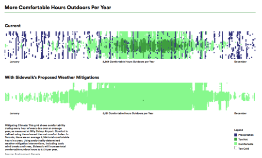
    I’m still making my way through the package, which I am obviously going to do, but I thought this was a great diagram:

    image

    As is stated in their RFP response, inclement weather affects pedestrians and cyclists more than drivers. Toronto’s most notable response has been our PATH system, which pulls both people and retail below grade, away from the elements.

    But Sidewalk’s research suggests that with the right wind, sun, and precipitation strategies, they may be able to 2x the number of comfortable outside hours per year here in Toronto. That’s what the above diagram shows.

    Of course, there is so much more in their RFP response. But I need more time to digest it all. I’ll be sure to report back to all of you once I have done that. If you don’t feel like going through all 196 pages yourself, you can watch this 4 minute YouTube video instead.

  • Empowering food truck entrepreneurs

    When I lived in Philadelphia I survived on food truck food. My go-tos were an egg and cheese breakfast sandwich for $2.50, a bowl of spaghetti for $4.50, and a pretty substantial chicken burrito for somewhere around $5 or $6. The food was good. It was filling. And it was all priced perfectly for a poor student, which I was at the time.

    I still remember when Renzo Piano came to the University to talk about potentially renovating the design school. Somebody stood up and asked if he had considered the placement of food trucks in his plans. Piano responded by saying: “I am Italian. Don’t worry. I will provide for the food.” This is how ingrained food trucks were and are in the culture of the city.

    The other great thing about these food trucks is that they are a low-cost way of starting your own culinary business. Many were run by immigrants. And some of these “trucks” were so small that I used to have to duck in order to make my way to the concession window. There was nothing fancy about them. But they worked.

    These days I don’t really eat at food trucks anymore. They are not as widespread here in Toronto as they are in Philly. I also find them expensive and the portions are usually so small that you have to order 2 or 3 things. They feel like the anti-food truck.

    I appreciate that there’s a growing market for trendy and “gourmet.” But there’s value in low-cost options and in lowering the barriers to entry for aspiring food entrepreneurs. There are numerous examples of humble food trucks growing into full fledged restaurants. Let’s encourage more of that.

  • The public life data protocol

    The Gehl Institute has just launched (in beta) something called the Public Life Data Protocol. It was developed by the Institute, as well as by Gehl (the practice), the Municipality of Copenhagen, the City of San Francisco, and Seattle’s Department of Transportation.

    The goal of the protocol is to improve the way in which we collect, share, and compare public space information. It is about improving public life in public spaces.

    To do this, they have proposed a series of metrics that measure everything from “posture within the space” to “objects brought into the space.” They also propose spatial metrics that help to analyze public life in relation to its physical context.

    Gehl is a real leader in this space. I commend them on opening up their methodology and working to create “a common language for people data.” Great data will only help us to build more human-centered cities.

    To download a full PDF of the protocol, click here

    Photo by Thaddaeus Lim on Unsplash

  • My old Philly apartment

    I’m in Philly right now for a good friend’s wedding. 

    I always feel nostalgic when I come back to this city. Some of my most memorable years were spent here. I grew a lot in those 3 years. I also think that Philly is a highly underrated city – such an intimate urban scale.

    I’m staying at the newly renovated Warwick Hotel in Rittenhouse Square. The lobby is beautiful, as are the corridors, but the rooms already feel a bit a dated to me. However the Barcelona Chair in my room is a welcome addition. That thing will never go out of style.

    My hotel happens to be two blocks away from my old apartment at 17th and Spruce. So I decided to do a walk-by while I waited for my room to be ready. My roommate and I had the entire second floor of this building:

    It was palatial, especially given the bargain price and its location in Rittenhouse Square

    The graffiti you see above is located on the north wall of the kitchen. I think that’s a recent addition. The fire stair you see provided access to the roof of the building (as well as the street, I hope). I’m not sure we were supposed to go up there, but we obviously used it for parties.

    Grillmaster Deli is still next door. They kept me fed when I was studying at home and too busy to cook. That was often. And across the street is the Italian restaurant with its sidewalk patio that I used to look out onto from my bedroom.

    This walk-up apartment was by no means fancy. Though it did have ensuite laundry, which was a nice improvement from my previous place. But it was unabashedly urban. My kind of place.

  • Thickets of haphazardly planned condo towers

    I couldn’t sleep last night, so I got up and pulled out an old issue of Monocle magazine from my nightstand. I then stumbled upon the following article by Taras Grescoe.

    What really stood out for me was this line:

    “Thickets of haphazardly planned condo towers, compacted amid neighbourhoods of single-family houses, have led to congestion nightmares in Toronto and notoriously out-of-hand housing costs in Vancouver.”

    It bothered me for a few reasons:

    – The frame of reference is the single-family house. It perpetuates the cultural bias that what matters most in cities, like Toronto and Vancouver, is low-rise housing.

    – I don’t get the “haphazardly planned” comment. New tower development has been heavily concentrated in the downtown core, growth centers, along the Yonge subway corridor, and so on. Their built form is also significantly influenced by their relationship to these low-rise “Neighbourhoods.”

    – I believe that building up, as opposed to out, is the way to address congestion nightmares. Though I will concede that our ability to plan and execute on transit in this city is positively deplorable. 

    – How did thickets of condos create an affordability problem in Vancouver? Many factors at play in this city, including a powerful geographic supply constraint.

    Those are just a few of my thoughts from early this morning. What are yours?

  • 3 pilot options for Toronto’s King Street corridor

    Anyone who has ridden Toronto’s King streetcar during rush hour can tell you that the service is broken. It’s unreliable. It’s overcrowded. And during peak times it can be faster to walk. Chart below.

    Part of the problem is a misallocation of resources. Only 16% of the people who use the corridor are in cars. And yet 64% of the physical space is allocated to drivers.

    Not surprisingly, this creates a bottleneck for the ~65,000 transit riders who use the service daily. (Busiest surface route in the region.) We are not optimizing for the right variable.

    It’s for this reason that the city is working on a rethink of the corridor. I wrote about this initiative last year, but earlier this week it got a bit more real with the release of the following 3 pilot block options.

    The plan is to launch a pilot sometime this fall (2017). This is good news. 

    If you’d like to go through the full King Street Pilot Study Public Meeting presentation, you can do that by clicking here. The above images were taken from that presentation.

  • Form follows parking

    “Form follows function” is a famous axiom of 20th century Modern architecture. It is based on the rational notion that architecture and its associated shapes, geometries, and spaces should be a direct result of their function. 

    It was a way of trying to eliminate the arbitrary ornament that had adorned previous architectural movements. In this case, if it had no function, then it should be stripped away.

    There have been many bastardizations of this pithy statement over time, but one of my favorites is: “form follows parking.” Obviously derogatory, it is this idea that much of the built environment is a result of parking requirements, rather than of more human factors.

    We see this in suburban building typologies (large surface parking lots), but also in urban infill projects where the below grade parking begins to dictate the structural grid and layout of the upper floors. It is, of course, necessary in many cases, but there’s also something subversive about parking having such a lasting impact on the spaces we occupy.

    That said, we know where the trend line is headed when it comes to parking. Streetblogs recently posted an article about the scarcity of parking in Manhattan and cited number of interesting stats.

    Because of the city’s bike-share program (introduced in 2013) and because of all of the bike lanes that have been added in recent years, the city has (rightly) removed approximately 2,330 on-street parking spaces in Manhattan south of 125th Street.

    Here’s another set of stats: 

    In 1998, New York City had about 810 parking lots and garages south of 60th street. Together, they accounted for approximately 112,826 parking spaces. As of last year (2016), the number of lots and garages had dropped to about 643 and the number of parking spaces to approximately 95,000. That’s a decline of about 16%, during a period of when the population of Manhattan grew by more than 100,000 people.

    I would also imagine that these pressures are increasing. So it is quite possible that “form follows parking” could be on its way toward obsolescence. I certainly feel it waning.

  • Driving in the HOT lane

    image

    Joe Cortright of City Observatory recently published an interesting post on HOT lanes (high-occupancy toll lanes) and cited a research paper by Austin Gross (University of Washington) and Daniel Brent (Louisiana State University). The paper looked at the behavioral response of drivers to dynamic HOT lane pricing. 

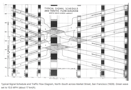
    They way HOT lanes work is simple: when traffic is light, the price dynamically decreases; when traffic is heavy, the price dynamically increases to ensure a minimum level of service. That is, the price increases until enough cars leave the lane and driving speeds increase to some minimum threshold. In this case, it’s 45 mph.

    The key takeaway from the report is that “value of reliability” appears significantly more important to drivers than “value of time”. Put differently: it’s less about the time I’m wasting in traffic and more about the uncertainty of not knowing when I’m going to arrive at my destination.

    It’s for this reason that HOT lanes are used more frequently in the morning (when you’re running late for that meeting) than in evening (when you’re just on your way home from work). 

    Gross and Brent estimate that the spread is about 7.5x. The typical driver values saving time at about $3 per hour and reliability improvements at about $23 per hour! This is fascinating because we tend to focus a lot on time. But arguably what people really want to buy is greater certainty.

    I can tell you that it’s definitely one of the things that I love about walking to work, or for that matter cycling somewhere. I always know how long it’s going to take.

  • The suburban Ponzi scheme

    The following image is a geographic representation of Lafayette, Louisiana’s finances. It is from this excellent article by Charles Marohn.

    What this 3D map shows is the city’s revenues and expenses by land parcel. The green areas are where the city is making a profit (revenues exceed expenses) and the red areas are where the city is operating at a loss (expenses exceed revenues). The height of each extrusion indicates just how much profit is being made and how much loss is being incurred.

    The glaring takeaway from this study is this: not only are post-war land use patterns environmentally unsustainable, but they are also fiscally unsustainable. The tax base is simply not there to pay for the infrastructure that gets built alongside it.

    They – the authors of this study – estimate that the infrastructure revenue gap for the median home in Lafayette is about $8,000 per year (median household income is $41,000). And yet despite this shortfall, it is common to look at infrastructure spending as a desirable economic stimulus.

    The following paragraph really brings this point home:

    “All of the programs and incentives put in place by the federal and state governments to induce higher levels of growth by building more infrastructure has made the city of Lafayette functionally insolvent. Lafayette has collectively made more promises than [it can] keep and it’s not even close. If they operated on accrual accounting – where you account for your long term liabilities – instead of a cash basis – where you don’t – they would have been bankrupt decades ago. This is a pattern we see in every city we’ve examined. It is a byproduct of the American pattern of development we adopted everywhere after World War II.”

    Thank you Daniel for sharing this article with me. 

    If you only read one other thing today (besides my blog), I recommend you read Charles’ article. It’s called: The real reason your city has no money.