Daily insights for city builders, delivered every morning at 6 AM ET. I’m Brandon Donnelly — a Toronto-based real estate developer and founder of Globizen. I’ve been writing here since 2013.

Tag: new york

  • The Buffalo Green Code

    At the end of last year, Buffalo, New York approved the first major overhaul to its zoning code in 63 years old. 

    It is officially called the Buffalo Green Code Unified Development Ordinance, but, not surprisingly, most people seem to be just calling it the Buffalo Green Code. Its name should give you clues as to what it is trying to accomplish.

    Here’s a snippet from a City Journal article by Aaron M. Renn:

    The Green Code is a so-called “form-based code,” encouraging mixed uses. Buffalo will be only the third major city in the U.S. to adopt a citywide form-based code. The goal is to encourage development of buildings in a more traditional, Main Street style.

    As an older city, Buffalo is already built like this in many areas. But past zoning choices have had lingering negative consequences. “Sixty years ago planners sought to replace the city with a suburban auto-dominated (dominated, not oriented) model,” says Brendan Mehaffey, Buffalo’s executive director of strategic planning. “Most of the city as built was non-conforming with the existing development. Through urban renewal and other programs, planners sought to replace the city’s built environment block-by-block.”

    Perhaps one of the most noteworthy changes being ushered in with the Green Code is the complete elimination of parking minimums. This change makes Buffalo the first city in the United States to remove this requirement on a citywide basis.

    The Green Code also dramatically simplifies the current code, taking it down from 1,802 pages to 338 pages.

    I haven’t yet gone through the Green Code in detail (you can do that here if you’d like). But already other cities are starting to look to Buffalo as a model for how to rewrite their own zoning codes.

  • Winter Wonderland (and 3 things to read)

    This is what it looks like in Mont-Tremblant right now:

    It’s currently -11 degrees celsius and it’s expected to snow for most of the day. It’s starting to come down right now. But this evening it’s supposed to warm up to +1 degrees celsius, which means it may turn into (freezing) rain. I hope we see a lot more snow than rain. Nobody wants an icy mountain.

    If you’re looking for things to read this morning, here are 3 pieces:

    1. In American Towns, Private Profits From Public Works. It’s a NY Times article talking about how cash-strapped towns are turning to private equity firms to pay for their infrastructure. 

    2. How Zoning Laws Shaped New York City Over the Last Century. This is about an exhibition being held at The Museum of the City of New York right now. The rules we make shape our built environment. Thanks John for the link.

    3. Authenticity, and how Snapchat is banking on it. I am very fascinated by Snap Inc.’s ability to think differently and adopt counterintuitive business strategies. There’s also a cultural dimension to all of this.

  • U.S. street grids compared

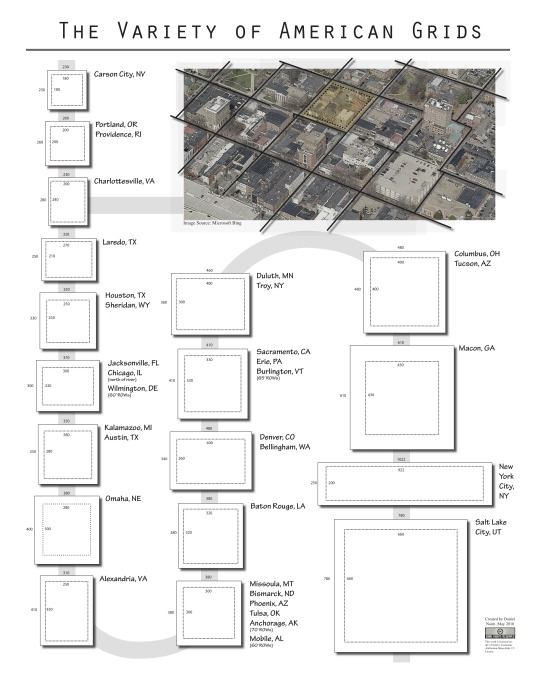
    I like this comparison of street grids that Daniel Nairn prepared back in 2010:

    There’s huge variation here. On the one end you have cities like Carson City, Portland, and Providence, which have small blocks (180′ x 180′ and 200′ x 200′). And on the other end you have cities like Salt Lake City, which have massive blocks (660′ x 660′). 

    This variation creates very different experiences for both pedestrians and drivers. It is widely understood that small blocks are better for walking, which is perhaps why Salt Lake City is known as a driving city. (I just learned that they have “crosswalk flags” to help pedestrians safely cross the street. What does that tell you?)

    In the case of New York – with its irregular rectangular blocks – it is arguably one of the reasons why the avenues (short side of the rectangle) have such a different feel than the streets (long side of the rectangle). Walking north-south is more enjoyable than walking east-west.

    All of this is even more interesting in the context of the point I made in this post: once these urban grids get laid out, they’re pretty sticky. That has far reaching implications.

  • One becomes four

    The New York Times posted an interesting article today talking about how roommates in the city are dividing and conquering expensive rentals using temporary walls. This is obviously not a new practice. But it’s a good case study in what people will do in order to make living in a specific location affordable – in this case, Manhattan.

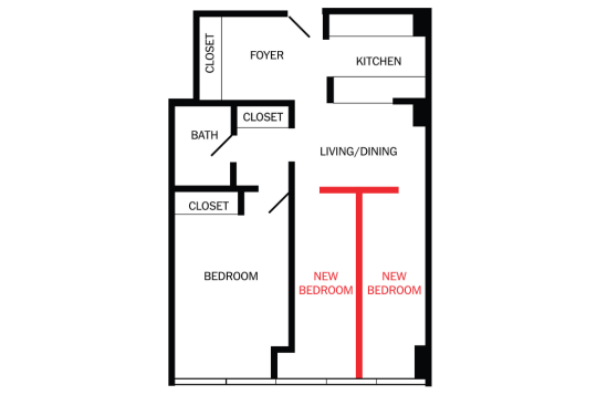
    The first example is a one bedroom apartment that was converted to a 4-person apartment. Here is the floor plan (from the New York Times):

    image

    The living/dining room was divided up using a T-shaped partition wall – which is required to stop 2 feet shy of the ceiling – to create two additional bedrooms. The original bedroom is then shared via two twin beds. Et voilà. Now you have an apartment where the $3,750 per month rent becomes less than $1,000 per person.

    Probably the most annoying thing about this setup would be the lack of acoustic privacy. Since the partition walls don’t go all the way up to the ceiling (photo here), you’d obviously hear everything. One person in the article described it as living in the same room as all of your roommates, but not being able to see anyone.

    Of course, there’s also a space consideration:

    Mr. Meyer, 23, has the smallest room by far. “It kind of feels like you’re living in Harry Potter’s cupboard,” said Mr. Meyer, who is in his freshman year at Columbia after serving for three years in the Israel Defense Forces.

    The roommates, three of whom grew up together in Toronto, don’t mind the close quarters or the lack of privacy. “It’s definitely not for everyone,” Mr. Meyer said. “When you live with your best friends, it couldn’t be better. We hardly spend time in our rooms.”

    I saw a lot of this here in Toronto while I was in undergrad. 55 Charles Street West was always a great candidate for these sorts of hacks because the units are large and because the building is filled with solariums. Inevitably, they became additional bedrooms. 

    (Sidebar: My understanding is that there was a period of time in Toronto where solariums were excluded from gross floor area calculations. So developers used to always put them in to capture more area. That’s why buildings of a certain vintage always seem to have them.)

    In any event, the above certainly makes the case for more micro units and co-living arranagements. Many people seem willing to deal with a variety of living situations in order to live where they want to live. Urban affordability is certainly a global concern.

  • Flood-prone areas see dip in real estate sales

    image

    The New York Times has an interesting article up talking about the possible impacts of climate change on coastal real estate in the United States. In it they make the argument that sales velocity is declining in flood-prone areas. Here are two snippets:

    Over the past five years, home sales in flood-prone areas grew about 25 percent less quickly than in counties that do not typically flood, according to county-by-county data from Attom Data Solutions, the parent company of RealtyTrac. Many coastal residents are rethinking their investments and heading for safer ground.

    In the past year, home sales have increased 2.6 percent nationally, but have dropped about 7.6 percent in high-risk flood zones in Miami-Dade County, according to housing data. Many coastal cities are taking steps toward mitigation, digging runoff tunnels, elevating roads and building detention ponds.

    I would like to see more data supporting this argument, but I can’t say I’m surprised. Flood risk is certainly something I would think about – particularly in high-risk areas such as South Florida. Florida has 6 of the 10 most vulnerable urban centers in the US.

    The other piece that caught my attention is this:

    Flood risks are easily overlooked because past flood damage often goes unreported and, as in Virginia, the burden of discovering it falls to the buyer. LexisNexis, a news and legal research company, can supply sellers a report with the history of flood claims on the property, but buyers usually do not know to ask for it. FEMA collects information on federal insurance claims for homes nationally, but the agency has been reluctant to make it public for privacy reasons.

    It is yet another example of how opaque the real estate industry is. A lot of the information – assuming it’s even available – is fragmented across a number of different sources. If you’re playing hot potato, this obviously works to your benefit. But I don’t believe it’s the best thing for the overall market.

  • The spatio-temporal hierarchy of urban form

    I was recently introduced to the work of Brenda Case Scheer – specifically a journal article she wrote called The Anatomy of Sprawl. If you’re the kind of person who enjoys geeking out about cities, this is for you. (Thank you Oliver.)

    What she does in the article is break down the various components / layers of a city according to the rate in which they change. Her “spatio-temporal urban hierarchy” includes: site (slowest rate of change), superstructure, infill, buildings, and objects (fastest rate of change).

    The way to think about this is that the bottom layers of a city – the paths and roads we have chosen to establish – are incredibly persistent. They don’t change all that often.

    On the other hand, buildings do change. Old ones get demolished. New ones get built. There’s a cycle. They too probably feel pretty persistent in many cases, but in comparison to our roads, they change far more frequently.

    The reason why all of this has bearing is because the paths we choose to carve out at the very beginning will ultimately dictate the kind of city that gets built and rebuilt over time.

    The rectangular grid of Manhattan was planned out in 1811. Central Park was missing from this original plan, but it did establish the street network and ownership lots that are now so central to the identity of New York City. That was a 200+ year decision.

    It seems to have worked out just fine for New York. But what if you’re in a position where the existing street network is viewed as failing and/or inappropriate for the future success of the city? 

    Well that’s where things get interesting. Now you need to dig down to some of those base layers and work on changing the (frequently) unchangeable. 

  • World’s best city brands

    Resonance Consultancy – they do brands and strategies for places and products – has just released a new report called: World’s Best City Brands – A Global Ranking of Place Equity.

    With all of these sorts of rankings, it really depends on the research methodology being used and the rigor in which it is being applied. In this case, they evaluated each city based on “six pillars of equity”:

    1. Place: Perceived quality of a city’s natural and built environment
    2. Product: A city’s key institutions, attraction and infrastructure
    3. Programming: The arts, culture and entertainment in a city
    4. People: Immigration and diversity of a city
    5. Prosperity: Employment, GDP per capita entertainment in a city and corporate head offices
    6. Promotion: Quantity of articles, references of a city and recommendations online

    What’s perhaps unique about this study is that it combines measurable statistics with “visitor perception metrics” – data that they mined from social media. Here’s an excerpt from the methodology page:

    “Our team became interested in the way visitors and citizens themselves influence the identity and perception of cities. Increasingly, they do it through their evaluation of experiences on social media and via the comments, images and reviews they share with family, friends and people around the world. These opinions and attitudes, much more than traditional marketing, influence the way people perceive places today.”

    This is a fascinating shift for city brands and is something that we have discussed before on this blog. All of us are now involved in telling the story of the places in which we live and visit.

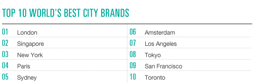
    The entire report is well done and worth a read. It’s also a free download (you’ll need to enter your contact info). But below are the top 10 world’s best city brands. Not really any surprises for me. What about for you?

    image

  • Crazy home prices

    image

    This afternoon I walked the High Line with a friend of mine who seemed to know everything there is to know about new residential development in Manhattan. 

    She recently purchased a place and so she had done her homework. She was pointing out every building and telling me the price per square foot range; whether the floor plans were well designed (or if they had misproportioned rooms and awkwardly placed columns); and who the architect was. 

    Takeaway: To be competitive in the luxury segment in New York, you really need to have a name brand architect on the project. That seems to be the price of entry.

    As she was telling me about the “competitively priced” building in the low $2,000′s psf and the expensive penthouse that recently sold for $7,000+ psf, I started to wonder about historical pricing in New York. How has it trended? 

    I also told her that you could buy a really great condo in Toronto for $700 psf. She laughed at how affordable that was. It’s all about your point of reference.

    In any case, I found a research report from 2004 called: Why is Manhattan So Expensive? The story is one that you’ve heard before. It’s about the impact of land use restrictions on home prices. But it does also include some historical data on average condo prices.

    In 1984, the median price per square for a condo in Manhattan was $359 psf. It peaked in 1987 at $505 psf and then dropped back down to the $300′s in the early 90′s. That was not a great time for real estate. However, by 2002, the median price had rebounded to $606 psf. All USD figures.

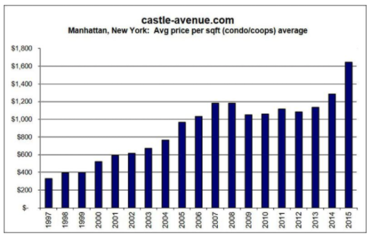
    From 2002 onwards, Manhattan saw a dramatic increase in home prices. Below are two charts from Corcoran (Q3 2016 data) and Castle Avenue, respectively:

    imageimage

    Toronto is obviously not New York, but’s interesting to consider that the average price of a downtown Toronto condo, today, is probably in the low $600′s psf. That’s in Canadian dollars and that’s pricing that New York saw decades ago. 

    It reminds me that “crazy pricing” can oftentimes be a psychological reaction to a pricing anchor that we previously set in our minds. It feels crazy. But is it?

    Image: Me

  • Total work of art

    image

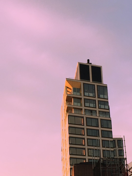
    I toured 56 Leonard Street in New York today. The only picture I have on my phone is the above photo of the lobby. The rest of the photos are on my Fuji and so they’ll make their way to my Instagram over the coming days. 

    There’s lots that has already been said about the architecture of 56 Leonard, but one thing I wanted to point out was this idea of a “total work of art.” The German word for this: Gesamtkunstwerk. I’ve written about this before, here.

    With many/most development projects, there will be a separate architect and a separate interiors firm. There’s absolutely nothing wrong with this approach, but it could lead to a disconnect between the exterior and interior. Or at least, some architects will tell you that.

    In the case of 56 Leonard, the architect (Herzog & de Meuron) also designed all of the interiors – right down to the kitchens, the sinks and tubs, the light fixtures, and likely a few other things. Hence the “total work of art.”

    It’s incredible to see what happens when you have one design sensibility brought to an entire project. 56 Leonard is beautiful. For the rest of the photos, make sure to follow me on Instagram.

    In case you’re wondering, the condo prices in the building run between $3,500 and $5,000 psf. One of the penthouses recently sold for USD$47 million.

  • Some thoughts on how we plan cities

    I came across this discussion on Twitter yesterday about how so many of the spaces we love in cities would not conform to today’s modern city planning practices:

    //platform.twitter.com/widgets.js

    This is a topic I’ve been thinking about lately and so it’s a timely discussion. In fact, I’ll often come across spaces in Toronto where I’ll think to myself: This is a really great space. But it’s highly unlikely that it could be built this way today. Naturally the question then becomes: What does this say about modern city planning?

    City planning is obviously important. But at the same time, we are almost certainly making mistakes and doing things that we will later regret. I say this not because I’m particularly critical of planning today, but because cities are enormously complex entities and it’s difficult to believe that we’ve figured everything out at this point.

    One thing I wonder about is if we aren’t over-planning and being too prescriptive about our cities. Some of you will probably argue the exact opposite. But hear me out.

    Vancouver is a city that has long been considered to be the gold standard in modern city planning. We talk about its podium + tower building typology. We talk about its “gentle density.” And we talk about its great public and recreational spaces, among many other things.

    But when I was there last month having dinner with a friend of mine, she said something to me that stood out. She said: “Brandon, Vancouver is a boring city. If it weren’t for my family being here, I would happily move to Toronto, New York, or somewhere else.”

    Cities are amazing places because they unleash human ingenuity. They allow new and unforeseen things to emerge. The challenge, I think, is to not sterilize that away when we plan and build. And all of us involved in the building of cities are probably guilty of doing that to an extent.