Daily insights for city builders, delivered every morning at 6 AM ET. I’m Brandon Donnelly — a Toronto-based real estate developer and founder of Globizen. I’ve been writing here since 2013.

Tag: mobility

  • How much market share are New York’s yellow cabs losing to Uber?

    Todd W. Schneider recently mined data from the New York City Taxi & Limousine Commission to create a chart summarizing yellow taxi, Uber, and Lyft usage

    The data only runs up until January 2016, but here’s what he found:

    “…yellow taxis provided 60,000 fewer trips per day in January 2016 compared to one year earlier, while Uber provided 70,000 more trips per day over the same time horizon.”

    The Uber data only begins in 2015, but you can still see how quickly it is growing and how yellow taxis are losing market share. Five years ago, yellow taxis were reaching over 500,000 trips per day (a pretty amazing number) and in January of this year they were at about 350,000 trips per day. 

    It also appears that Lyft is struggling to gain traction.

    image

    What’s also great about Todd’s blog post is that he has set it up so that his chart will automatically update as new data becomes available. So if you’re interested in this topic, you should bookmark his post.

  • Toronto’s rapid transit network by 2031

    Starting today and running until the end of March, the City of Toronto, the Toronto Transit Commission, and Metrolinx will be hosting several public meetings as they work towards planning out this city and region’s rapid transit network.

    Below are a few of the key maps from their presentation.

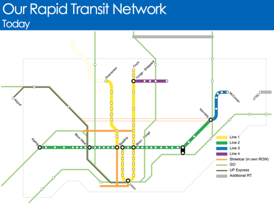
    Here is what Toronto’s rapid transit network looks like today (the hollow lines represent projects in construction):

    image

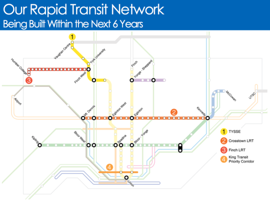
    Here is what will be built within the next 6 years:

    image

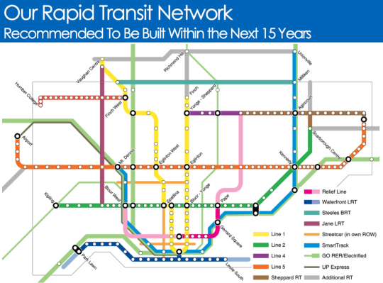
    And here is what they are recommending should be built within the next 15 years:

    image

    It’s hard not to get excited when you see maps like this. Of course, it’s a lot easier to draw lines on a map then it is to fund and execute on projects like this.

    But I think it all starts with us acknowledging that these initiatives are critical to both our economic competitiveness as a city region and our quality of life as citizens of it. Because if this is something we really want, then we can absolutely make it happen.

    Click here if you’d like to see the full presentation and also the public meeting dates/times.

  • 3 changes to John Tory’s SmartTrack transit plan

    Last week Oliver Moore of the Globe and Mail announced that Toronto mayor John Tory’s SmartTrack transit plan is evolving to feel less like SmartTrack and more like what Metrolinx had been planning all along.

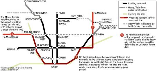
    Here’s the map from the Globe and Mail:

    The 3 big changes are as follows (and numbered accordingly on the above map):

    1. 

    The western end of the line will be replaced by an extension of the Eglinton-Crosstown LRT (currently under construction) running from Mount Dennis to Pearson Airport. This is what was originally proposed.

    2. 

    The “U” running from Mount Dennis in the west, down through downtown, and up to Kennedy in the east is what remains of the original SmartTrack line and will operate as some sort of “heavy rail” service on existing GO Transit lines. The original election campaign plan was to run trains every 15 minutes, but that was deemed too infrequent to attract riders, so now Metrolinx and everyone is trying to figure out how to get it down to every 5-10 minutes and feel more like subway.

    3. 

    The extension north of Eglinton Avenue to suburban Markham (in the northeast) is being pushed out and will be dealt with sometime in the future. Keeping the first phase of SmartTrack south of Eglinton on both ends is beneficial in avoiding the issue of SmartTrack and the Scarborough subway extension cannibalizing each other. (In my opinion, this issue is a perfect example of what happens when transit planning becomes too political.)

    The net result is a plan that is looking less and less like the original SmartTrack. I’m not complaining though because I have never been a big supporter of SmartTrack. I have always thought we should be focusing on the downtown relief subway line and on allowing Metrolinx to just execute on its regional express rail (RER) strategy.

    For more on this topic, check out Steve Munro’s post, SmartTrack: Now You See It, Now You Don’t! He’s far more of an expert than I am on these sorts of issues.

  • Rethinking downtowns to improve urban mobility

    Jarrett Walker of Human Transit recently published an interesting post talking about downtowns. His argument is that we shouldn’t be planning our transit networks around the traditional notion of a single-centered city.

    Here’s a snippet:

    So growing a single downtown isn’t the key to becoming a great transit city. Quite the opposite, it’s best to have a pattern of many centers, all generating high demand, and supporting balanced two-way flows between them that let us move more people on less infrastructure.  This is the great advantage of Paris or Los Angeles or the Dutch Randstad over Chicago or Manhattan.

    Now, there are many cases where a singular economic center still dominates an urban region. See downtown Toronto. And many will argue that the current economic environment is creating more, rather than less, concentrated urban spikiness.

    But at the same time it is quite clear that many of our cities have shifted away from a monocentric model to a polycentric one. 

    I mean, just look at all employment nodes that have developed across the Toronto region. The idea that everyone comes downtown in the morning and then leaves in the evening has become an anachronism for many. Early in my career I spent 4 years commuting from downtown to the suburbs.

    So what is happening is that our cities need to start performing more like point-to-point networks. This isn’t a new thought. But it’s a lot harder to execute on compared to what many cities have been used to. 

    You need a critical density of both residents and employers and the right kind of connectivity to create a true “mobility hub.” In Toronto, you could argue that we really only have one of those and it’s centered around Union Station.

    But I think that will change for many cities. And when we do get it right, we will be doing a lot to improve the crippling traffic congestion that so many of our cities are suffering from.

  • Ridesharing could help solve the last mile problem

    X by Keith Mokris on 500px.com

    https://500px.com/embed.js

    A few months ago I wrote a post about Uber’s new “Smart Routes” feature and ended by saying that it’s not just taxis who need to be thinking about platforms like Uber, it’s also public transit authorities.

    I said that because I think that multi-modal is already the new reality in terms of how we get around cities and because the line between different modalities is becoming greyer all the time.

    That’s why I was interested when I stumbled upon this NextCity article talking about how Lyft is starting – it’s still early days – to collaborate with transit authorities in order to make it easier for people to switch between public transit and its peer-to-peer ridesharing marketplace.

    Why might this matter? Here’s an excerpt from the article:

    “According to the company’s data, 25 percent of Lyft riders say they use the service to connect to public transit. In Boston, 33 percent of those rides start or end near a T station. And transit hubs like Chicago’s Union Station, D.C.‘s Union Station and Boston’s South Station are among the most popular destinations for its users, Lyft finds. So riders already see on-demand rides as a solution to the first mile/last mile problem. Lyft thinks it can do more.”

    These last 2 sentences are interesting. Public transit can often suffer from what is known as the first mile/last mile problem. This is a problem where riders find it difficult to get to the nearest transit route from their departing point or to their ultimate destination once they exit transit.

    Bikesharing can be used to solve this. But, clearly, so can ridesharing.

    The other important aspect of this emerging collaboration is that ridesharing apps can offer a lot of incredibly valuable data to transit authorities. If 25% of users are indeed using it to connect to public transit, then all of a sudden cities are getting a more complete picture of point A to B travel. (Among many other things.)

    But the question in my mind is now, who is going to and who should act as the overall steward in this multi-modal urban mobility network? 

    There are lots of different players involved. Some are public and some are private. But they all play a role in how we are going to continue moving around our cities.

  • The London Crossrail

    On Thursday afternoon the mayor of Toronto, John Tory, was in London meeting with their mayor, Boris Johnston, and talking about Toronto-London business relations, the economy, and transit.

    Here is the tweet:

    //platform.twitter.com/widgets.js

    On the topic of transit, the big item to see and discuss was The Crossrail. For those of you who might not be familiar with it, here are a few bullet points from their website:

    Crossrail is Europe’s largest construction project – work started in May 2009 and there are currently over 10,000 people working across over 40 construction sites.

    The Crossrail route will run over 100km from Reading and Heathrow in the west, through new tunnels under central London to Shenfield and Abbey Wood in the east.

    Crossrail will transform rail transport in London and the south east, increasing central London rail capacity by 10%, supporting regeneration and cutting journey times across the city.

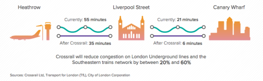
    Crossrail will bring an extra 1.5 million people to within 45 minutes of central London and will link London’s key employment, leisure and business districts – Heathrow, West End, the City, Docklands – enabling further economic development.

    And below is a neat diagram that I found in this City of London report. I think it does a good job summarizing some of the spatial impacts of The Crossrail.

    image

    In the past I’ve been negative about John Tory’s SmartTrack proposal, which is clearly inspired by The London Crossrail. I had my reasons for that. But I want to be clear that I am not in any way negative on Regional Express Rail as a mobility solution.

    Toronto would benefit greatly from RER and Metrolinx is working diligently to deliver it to the region. I can’t wait for that to happen so I can drive even less than I already do.

  • From map books to Google Maps

    When I was a kid I remember my parents having something called a “Perly’s” in their car. It was basically a map book and it was the best thing around. 

    You would start by looking at a big grid of the city and then you’d find the specific area you were looking for and then flip to that page. If you were on the road a lot for work, a Perly’s was a mandatory addition to your car.

    Things have obviously come a long way since then. It could take you a long time to find the street you were looking for in a Perly’s. I remember doing that from the passenger seat. Now our phones do that for us and if the connection makes us wait for more than few seconds, we get irritated.

    But we’ve also moved beyond just static maps. 

    The other morning I was driving out to the suburbs and I saw this road sign telling me that – given current traffic conditions – it was going to take me 15 minutes to get to HWY 427. 

    image

    Have you ever wondered how they come up with those time estimates?

    There are a few ways to do it. But here in Toronto along the Gardiner Expressway and Lake Shore Boulevard it’s done using your mobile phone. Phones have unique network identifiers called MAC addresses. And when they try and connect via Bluetooth or Wifi they actually send out their MAC address.

    So what happens as you’re driving along is that your phone’s MAC address is being picked up at various locations. And since the distance between these various reception points is known, it’s pretty easy to determine how fast you’re traveling. That’s how they come up with those time/traffic estimates. 

    This data is anonymous but, in theory, the city also knows if people are speeding when the traffic is light.

    This same technology is being used by many retailers and shopping malls to track how people move through their spaces. It’s used to see, among other things, which merchandising strategies are working and what synergies one might be creating (or not creating) with the tenant mix.

    But getting back to traffic, there are obviously ways to collect traffic data without any additional physical infrastructure.

    As I was about to leave the suburbs and head back downtown, my phone somehow knew I was about to do that (perhaps because I was stopped at a Starbucks near the highway) and so it decided to tell me this:

    image

    It wasn’t the best notification to receive on my phone, but I was impressed nonetheless. This traffic data is collected using GPS data transmitted from mobile phones using Google Maps, Apple Maps, and so on. Clearly we’ve come a long way since the days of manually leafing through a thick Perly’s.

    At the same time, it feels like we are still pretty far away from solving the problem of urban congestion. Every big city in the world is grappling with this issue

    Part of the problem, I think, is the belief that there’s some sort of silver bullet – more highways, a magic smartphone app, and so on – that will enable everyone to be able to drive around in their own car by themselves. I don’t believe that’s possible in big cities. And the sooner we get away from that toxic thinking, the quicker we’ll solve this problem.

  • How to save 8 minutes on Toronto’s highways

    City in Colour by Greg Patterson on 500px.com

    https://500px.com/embed.js

    Three months ago when Toronto City Council voted
    not to remove the Gardiner Expressway
    East (which in
    my view was a mistake
    ), it did so with a commitment to look at tolling
    options for both the Gardiner Expressway and the Don Valley Parkway (which in
    my view is a positive thing
    ).

    Last week a preliminary report was released
    discussing some of those tolling options. If reading dry city reports is your thing,
    you can do that here.

    The Coles Notes version (CliffNotes for you
    Americans) is that a $3 flat toll on both the Gardiner and the DVP – the same
    cost as riding transit in this city – would be expected to reduce vehicles on the highways by 9% and 12%, as well reduce end-to-end travel times by 3 minutes and 5
    minutes, respectively. There’s obviously a lot more in the report, but these
    figures stood out for me.

    Given how monumental the
    3 minute delay
    was in the Gardiner East debates, it will be interesting to
    see whether people treat a 3 minute time savings in a similar way. I suspect
    they won’t. The cost will be the larger issue.

    I’ve been a
    vocal supporter of tolls and road pricing on this blog
    . One of the main reasons
    for that is because I view the demand for highways as being largely inelastic
    and therefore a potentially great source of transit funding.

    The discouraging part of the above report is
    that its primary goal is to explore tolls for the purpose of “offsetting
    capital, operating, and maintenance costs.” The primary goal is not to come up
    with sustainable sources of transit funding.

    Having these costs paid for by user-fees as
    opposed to general taxes is still a good thing in my view. But an even better thing
    would be to help fund mobility solutions that we know will be far more
    effective at getting people around this region as millions more people move here
    in the coming decades.

    The other discouraging part of the report is
    that near the end it explains that while the City of Toronto Act of 2006 allows
    for toll highways, they cannot be implemented without the Province passing
    regulation.

    It’s a reminder that our governance structures do
    not reflect the current urban reality of this country.

  • Guest Post: For whom the road tolls?

    For those of who were following Architect This City during the Gardiner Expressway East debate here in Toronto, you might remember that Darren Davis (transport planner with Auckland Transport) wrote a guest post called, Three minutes that rule the world – Will demolishing the Gardiner East actually make traffic worse?

    It was an incredibly popular post at the time, so I’m thrilled that Darren volunteered to do another one on road tolls. This is a topic that I’m very interested in and have written about a few times. Road pricing, as you’ll see below, puts us in a bit of a chicken-and-egg situation. But sooner or later I think we will need to get our head around it, as will many other cities.

    I hope you enjoy today’s post. Thanks again Darren.

    ——————————-

    A recent post on Architect This City, The Tragedy of the Commons, raised a fundamental but all too often forgotten point about transportation: That in networks where the price of use doesn’t change when demand changes, there is no effective mechanism to manage that demand.

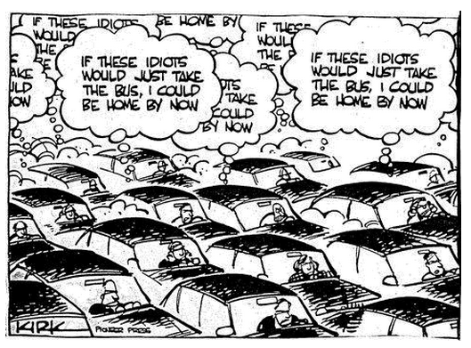
    Because there is no incentive to act in the public good, we often act in what we perceive to be our own personal interest, which is often the antithesis of the public interest. And remember that if we are driving, we are traffic. So often people will sit fuming in their cars in the midst of congestion with thoughts like in this cartoon. But of course with unpriced roads, there is no real price signal to these drivers to consider taking the bus.
    In a world where time is money, we are constantly berated about the economic costs of congestion. In 2011, the Toronto Board of Trade estimated that congestion in the Toronto region alone cost the regional economy $6 billion a year, rising to an estimated $15 billion in 2031 should no action be taken. More recent research by the CD Howe Institute pegs this figure at up to $11 billion.

    Given these sorts of eye-watering figures, one might be tempted to think that car drivers, and in particular the goods industry, would be flinging their wallets open at the chance to buy their way out of congestion. And in fact Toronto has the 407 Express Toll Route which has elements of variable road pricing. However, while the 407 ETR carries around 350,000 vehicles per day, price increases have been matters of controversy. It provides some ability for those who can afford it to bypass Toronto’s notorious traffic congestion, but its fundamental weakness is that it’s just one road in one of North America’s largest city-regions.

    Similar stand-alone efforts to address congestion in Metro Vancouver with tolled routes, such as the Port Mann Bridge on the Trans-Canada Highway and the Golden Ears Bridge, have fallen well short of their projected traffic volumes, while nearby untolled bridges such as the Patullo Bridge are heavily congested. We have a similar experience in New Zealand where our two tolls roads, with car tolls of $2 and $2.20 respectively, experience diversion rates of up to 30% to the alternative but substantially longer and slower free routes.

    This brings up a fundamental paradox: Congestion costs the economy a fortune and congestion is a top-of-mind frustration, yet people seem reluctant to pay even comparatively small amounts to bypass congestion.

    For example, the City of Toronto’s Roundtable on Gridlock & Traffic Congestion in February 2014 came up with the usual shopping list of “transportation systems management” responses – improved management of curbside space and construction projects; synchronized traffic signal phasing; better traveller information and improved incident response. While these are all worthwhile responses, they only improve system operation at the margins. Encouraging greater use of public transit was the very last recommendation and there was not a single mention of charging or pricing as a tool to address congestion. And the feverish activity continues with a hackathon called TrafficJam on October 2 – 4, 2015 with the goal of fixing Toronto’s traffic woes.
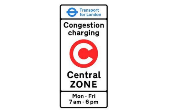
    The very few cities that have actually had significant success at reducing traffic congestion – notably Singapore, London and Stockholm – have done this through cordon-based congestion pricing wherein if you pass the cordon, you pay the congestion charge. Entering central London on a weekday between 7am and 6pm will set you back a cool £11.50 ($C23.30). From 2003 to 2013, about £1.2 billion ($C2.42 billion) of congestion charge revenue has been invested in public transport, road and bridge improvements and walking and cycling, of which £960 million ($C1.94 billion) was for bus improvements. These measures have included significant road space reallocation to improve conditions for pedestrians, cyclists, public transit and the urban realm.

    The latest Travel in London report states that “Over the 10-year period from 2003, total trips have increased by 11.4 per cent, with particularly notable increases of 52.3 per cent in rail trips and 32.0 per cent in Underground and DLR [Docklands Light Railway] trips, with cycle trips (as main mode) increasing by 53.9 per cent. Car driver trips decreased by 12.7 per cent over the same period” (my emphasis).

    One interesting insight is that Stockholm trialed congestion charging and then reverted to business as usual of unpriced roads in advance of a referendum on congestion pricing. This gave Stockholmers a clear sense of the difference in traffic congestion and was crucial in supporting a yes vote in the referendum.

    Stockholm has experienced a permanent reduction in traffic of about 20% across the toll cordon and congestion decreased by 30 – 50% – which demonstrates that traffic volume reductions have a disproportionately positive impact on congestion. About half of the “disappearing” drivers changed to transit, the rest to other alternatives such as different departure times and destinations and taking fewer trips.

    For more on Stockholm, I suggest reading the Tools of Change case study on Stockholm Congestion Pricing.
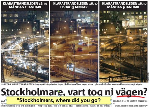
    Before and after congestion charge photos of traffic levels in Stockholm

    While this sounds very promising, congestion charging has significant equity implications and requires upfront investment to provide people who either choose to or can no longer afford to drive with transportation alternatives. Both Stockholm and London invested very heavily in public transit in advance of implementing congestion charging.

    And this brings up a big issue for Toronto. 

    For congestion charging to have a meaningful impact on congestion without stifling economic activity or impeding people’s ability to move around, the core capacity of Toronto’s transit system would need to be addressed first. In particular the Yonge Line capacity enhancements, Metrolinx’s Regional Express Rail and most likely the Downtown Relief Line would need to be in place to provide both capacity and choice for people who either needed or wanted a travel alternative to any congestion charge.  This would mean that Metrolinx’s Big Move might need to get even bigger.

    Disclaimer: The author of the above post is an employee of Auckland Transport, however, the views, or opinions expressed in this post are personal to the author and do not necessarily represent the views of Auckland Transport, its management or employees. Auckland Transport is not responsible for, and disclaims any and all liability for the content of the article.

  • The taxi cartel

    https://500px.com/embed.js

    Early this morning Peter Cheney of the Globe and Mail published an article called: How Uber is ending the dirty dealings behind Toronto’s cab business.

    And I highly recommend you read it. He’s been investigating this industry for decades.

    Though the article is specific to Toronto, I know that there are middle people and archaic policies governing the taxi industries in many other cities around the world.

    Here it revolves around taxi licenses issued by the city (known as “plates”), which are expensive and almost impossible to get. Last year the average price of a plate was $118,235 (2014).

    The way it works is that people – typically non-drivers – buy/inherit/get these plates and then charge rent on them to drivers who want to use them. The result is a taxi cartel:

    In fact, Toronto’s taxi plate system is anything but free enterprise. Instead, it is based on the artificial restriction of a natural market, and the granting of licences to a fixed number of participants. Even those who paid top dollar for a plate used to enjoy an annual return of more than 12 per cent. And for those who inherited plates, the return was manna from heaven.

    So it shouldn’t come as a surprise that the taxi industry is grouchy about companies like Uber. But the cost structure of the incumbents is going to need to change if they want to stay in business.

    Jeff Bezos of Amazon is famous for saying, “Your margin is my opportunity.” And that’s exactly what is happening here. A bloated legacy cost structure is being quickly supplanted by better/cheaper.