Daily insights for city builders, delivered every morning at 6 AM ET. I’m Brandon Donnelly — a Toronto-based real estate developer and founder of Globizen. I’ve been writing here since 2013.

Tag: history

  • Ontario Silver Mining Company

    If you hang around Park City long enough, you will come across things with the name Ontario. There’s Ontario Avenue. There’s the Ontario hiking trail at Deer Valley. And I’m sure there are other things.

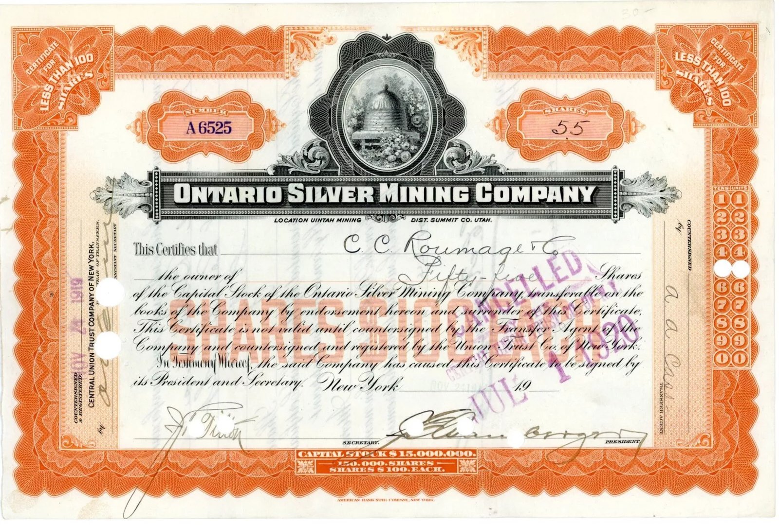
    As a Canadian, I couldn’t help but wonder why. So today I looked it up. And it turns out that the mining company that first put Park City on the map was the Ontario Silver Mining Company (see above stock certificate).

    Established in 1872, it was a major contributor to Park City’s economy (when it was a mining town) and it is usually credited as the mine that generated the most consistent yield in Utah during the late 19th century.

    Cool, so why was it called Ontario? Well, according to the Park City Museum, the mine was first discovered by prospectors from Canada (though they later sold off their claim to George Hearst for a handsome $30,000).

    I can’t seem to find any info about these Canadians, but the province of Ontario did get its name in 1867, so at least the chronology check outs.

    Image: Park City Museum

  • Homes per acre

    I spent three years living in Philadelphia for grad school and one of the things that I appreciated the most was its walkability. I walked and took transit everywhere. Much of this has to do with the grid system that was laid out for the city in the 17th century. But there are also lots of more recent developments that help to reinforce this fabric.

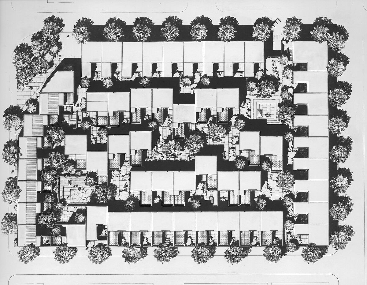
    CityLab, for example, just published this article on Penn’s Landing Square, which is a housing complex in Philadelphia’s Society Hill neighborhood. Built in 1970 and designed by Canadian-American architect Louis Sauer, the modernist complex occupies an entire 2.37-acre block and contains an assortment of 118 low-rise homes, many of which are connected through small interior laneways.

    Here’s the site plan:

    In addition to its handsome architecture, what is noteworthy about Penn’s Landing Square is that its site plan makes it quite a dense low-rise development. At 118 homes, this translates into just under 50 units per acre. CityLab estimates that this means the development holds about 174 people per acre (~412 people total), which would make it more dense than Stuyvesant Town in New York (~158 persons per acre).

    However, this is based on the assumption that there are almost 3.5 people living in each of these homes. While generally large, I don’t know if this is the case. It would be higher than the average US household size. But regardless, from a unit per acre standpoint, it remains a great example of dense, family-oriented, and grade-related housing.

    For fun, let’s compare this to a more intense form of infill development. Our Junction House project, for instance, contains 151 homes and sits on a 0.48-acre piece of land. This translates into about 315 units per acre. I don’t know off hand the average number of occupants per household, but I reckon that, given our larger average suite size, we should be on the higher end compared to most mid-rise condominiums. So I would say that we are probably 400+ people per acre.

    It’s unfair to compare a single development to an entire neighborhood, such as Stuyvesant Town. Circulation and other open spaces will necessarily pull down your average density. But these individual development examples do speak for themselves. There are many parts of North America where you might find 1 home or a handful of homes per acre of land. At Penn’s Landing Square, this number is 50 units per acre. And at Junction House, it’s 315 units per acre.

  • The greatest photo of Venice I have ever seen

    This afternoon we went to the Mucem (Museum of Civilizations of Europe and the Mediterranean) here in Marseille. By far, my favorite exhibition was one that dealt with the urbanization of five cities surrounding the Mediterranean — namely Marseille, Venice, Istanbul, Cairo, and Alger. At one point, this was the center of the commercial world. Great empires were forged and great fortunes were made here. But things have changed a little since then. And in some cases, what we are now left with are scenes like the one you see above (photograph by Martin Parr). This is easily the greatest photo of Venice I have ever seen. Venice is a tiny city, but it receives tens of millions of tourists each year. This photo does an extraordinary job of capturing what that might feel like.

  • Do, and then theorize

    Architecture school has a way of indoctrinating you with an appreciation for the past. One of the ways that is done is through architecture history and theory classes.

    In my case, I was taught to appreciate the work of Le Corbusier, Mies van der Rohe, Louis Kahn, Adolf Loos, and many other influential architects from the 20th century.

    It was okay to disagree with their ideas, but you at least had to learn about all of the important stuff that they had done and/or thought about. It’s a standing on the shoulders of giants kind of thing.

    But as Witold Rybczynski argues in this recent post, it’s important to keep in mind that history and theories are written after the fact:

    “Some buildings are, in a sense, experiments, and when something works, and is taken up by others, it eventually becomes a rule of thumb, perhaps even a theory.”

    For me, this is yet another reminder that the world moves forward as a result of doing, creating, and making new things happen.

    Sometimes you’ll get it wrong and do the wrong things. But sometimes you’ll do something wonderful that nobody else has thought of before.

    And when then happens, the world will have moved forward such that it’s then possible to look back at what happened and make sense of it all.

    As Witold puts it, “first you build a flying machine, and later you discover the aerodynamic theory that supports flight.”

  • The lost history of Seneca Village

    This is a fascinating short video (by Vox) about a former neighborhood in Manhattan known as Seneca Village. Today, its land forms part of Central Park.

    Most of us would probably agree that building Central Park was both a good idea and a powerful example of the value of foresight.

    But that doesn’t mean that the area’s pre-park history is something that should be forgotten. (Thanks for sending this along, Jeremiah Shamess.)

    If you’d like to learn more about Seneca Village, check out this NY Times opinion piece by Brent Staples. It’s called, The Death of the Black Utopia.

  • The work of centuries

    Witold Rybczynski’s recent post about the tragic fire at Notre-Dame de Paris provides an interesting summary of cathedral construction techniques over the years:

    The Paris fire is also a reminder of what a weird hybrid structure Gothic cathedrals really are. The ancient Romans roofed their basilicas and baths with concrete vaults (the Pantheon with a dome), and the Byzantines used thin domes and vaults of brick. Over time, builders lost these skills and Romanesque cathedrals were roofed with exposed timber rafters like big barns. This made the buildings highly susceptible to fire, often caused by lightning strikes. The solution, pioneered at Durham Cathedral in the 11th century, was to build a lightweight ribbed stone vault over the nave. The timber roof remained, so the vault had no structural function (except to support itself) but it separated the interior from the flammable roof above. This was largely effective as the April 15 fire shows.

    Below is an image from the WSJ depicting Notre-Dame’s timber rafters and showing the extent of the area consumed by the fire. Fortunately, relatively little of the cathedral was actually destroyed.

    Going forward, there will almost certainly be a debate about how the roof and spire should be rebuilt. What materials and construction methods are appropriate for this emblem of Christianity and French culture?

    But I agree with Witold in that “there is nothing inauthentic about rebuilding.”

    It is common to lament that buildings simply aren’t built like they used to be. But this is not a new phenomenon. Construction methods change, as do the skills of builders.

    There may have been critics in the 1220’s complaining about how the cathedral’s roof was built using wood, instead of concrete or brick vaulting. But that’s what was relevant at the time.

    We also know that there have been periods of time since its construction where Notre-Dame simply languished. In fact, some have argued that this week’s fire was the result of decades of neglect.

    But Victor Hugo once wrote that, “great buildings, like great mountains, are the work of centuries.” Despite what unfortunately happened this week, that remains true of Notre-Dame de Paris.

  • Dendrochronology of U.S. immigration

    I can’t remember where I found it, but I recently stumbled upon this video simulating the dendrochronology of U.S. immigration from 1830 to 2015. 

    It is part of an ongoing project by Pedro Cruz, John Wihbey, Avni Ghael, and Felipe Shibuya, and is supported by Northeastern University.

    As its name suggests, the video (and broader study) uses the metaphor of a tree (and its growth rings) to explain historical immigration to the U.S. 

    If you can’t see the video below, click here.

    [vimeo 276140430 w=640 h=280]

  • The Hess triangle

    A friend of mine recently shared this Twitter thread with me. It is by Chaz Hutton. I didn’t know who Chaz was before I read the thread. But I now know that he draws things, sometimes for the New Yorker.

    Chaz’s Twitter thread covers the history behind what was once believed to be the smallest plot of land in New York City. He also positions the story as the “perfect embodiment of New York’s attitude.” Guess what the means.

    The story is about the isosceles triangle pictured above, measuring 25-1/2″ at its base and 27-1/2″ along its sides. It is known as the Hess triangle and it reads: “Property of the Hess Estate which has never been dedicated for public purposes.“

    Click here for the full story.

    Image: Chaz Hutton

  • Below the surface

    Later this month the new 9.7 km North-South metro line in Amsterdam will start service. Like most large scale infrastructure projects, its opening has been delayed many times. 8 times according to this source. But this post is not about that. It’s about a byproduct of the line’s construction. 

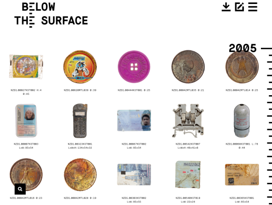
    The excavations required for the line meant that two sections of the Amstel River – namely the Damrak and Rokin sites – had to be drained. This took place from 2003 to 2012 and gave archaeologists unprecedented access to the bottom of a river in the middle of a historic city center.

    Amsterdam started as a small trading port along the banks of the Amstel River some 800 years ago. So not surprisingly, they found a few things. Over 17,000 objects were found and all of them have been catalogued online according to time period, use, material, and location found.

    For the full catalogue of objects, click here. Screenshot of the catalogue shown above. And to learn more about the entire project, start here. There’s a lot of good stuff in there for city nerds.

  • Those wretched rear houses!

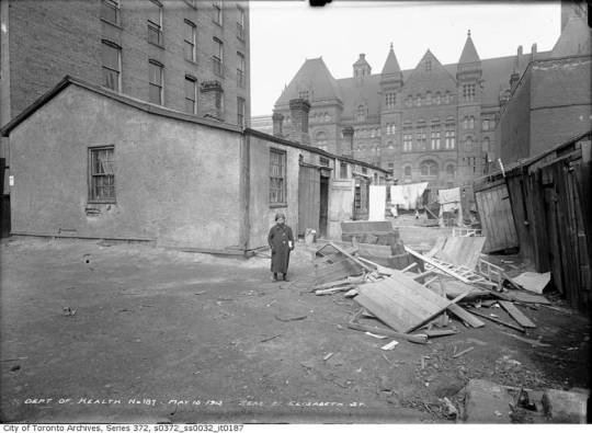
    Chris Bateman does some terrific sleuthing in the Globe and Mail this week to determine that the girl pictured in the below photo, dated May 15, 1913, is Dora (Dorothy) Cooperman – daughter of Morris Cooperman, a clothing presser.
    image

    Dora is standing in front of 3 wood-framed “rear houses” located behind 21 Elizabeth Street in an area known then as St. John’s Ward, or simply, The Ward. Behind her is City Hall, which we refer to today as Old City Hall. 

    If you’re familiar with Toronto, it shouldn’t take you long to figure out that she is standing in what is today the middle of Nathan Phillips Square in front of (new) City Hall. 

    The Ward no longer exists today, but as far as neighborhoods go its history is one of the most interesting. It was a high-density and mixed-use precinct that served as an important landing ground for successive waves of immigrants until it was deemed a slum and ultimately cleared. I wonder what it would look like today had it remained. Perhaps a bit like Kensington Market.

    It housed the Irish fleeing the Great Famine in the 19th century and was the center of Toronto’s Jewish community until the 1920s. The Cooperman family came from Kiev and identified as Jewish.

    There are so many interesting aspects to the above photograph. Everything from Dora’s pose to the juxtaposition between her surroundings and the grand (old) City Hall in the background. (Sidebar: I would like to try and recreate this same perspective. Would anyone like to model?)

    I also wonder why the city required a report to wake them up to the squalor that was living out in the Ward when they could have, presumably, just looked out their west facing windows.

    In 1911, Charles Hastings and Arthur Goss published what Batemen describes as a “landmark report that stunned civic officials, who had long ignored the poverty on their doorstep.” Hastings was the city’s medical officer of health, and Goss was the’s city first official photographer and author of Dora’s above portrait.

    One of the interesting things that Bateman explains about this report – and this is really the point of today’s post – is that it supposedly called out one particular housing typology as being highly problematic: rear houses. 

    These were houses that existed off the main street and could only be accessed via a laneway, like the one Dora is standing in. Today we would call them laneway houses. And so this report is evidence of over a century of anxiety around this particular housing type.

    It is obvious why overcrowding would have been deemed a serious problem at the start of the 20th century, but now one has to wonder how influential this report may have been in establishing the tone around these “rear houses.”

    Whatever the case may be, Dora’s story is an example of the role that this typology has played in housing people of modest means throughout this city’s history. It is also interesting, but perhaps not a coincidence, that affordability continues to be a part of the pitch around laneway housing and laneway suites. 

    Dora lived in a laneway house.