Daily insights for city builders, delivered every morning at 6 AM ET. I’m Brandon Donnelly — a Toronto-based real estate developer and founder of Globizen. I’ve been writing here since 2013.

Tag: gardiner expressway

  • My approach to blogging

    In yesterday’s post about the city as an egg, I received a comment basically saying that I use this blog to carefully curate my own image and that I would never argue against “dumb Toronto planning” because, after all, I’m a developer. I am going to do what breads my own butter.

    I welcome intelligent debate on this blog. That’s why it is open to anyone who would like to comment. But since I’ve received similar comments in the past, I thought I would use the opportunity to talk broadly about my approach to blogging.

    Firstly, there will always be some level of curation involved. That’s inevitable. We see it all over social media. But I’m a big believer in transparency and I try to do exactly that on this blog. I am keen to push the boundaries in this regard.

    At the same time, part of what makes blogs unique is that they’re often personal. That is the origin of blogging. Some of my favorite blogs to read are the ones that have figured out how to combine a particular niche topic with personal stories. And since ATC is ultimately my personal blog, I am going to continue taking that exact same approach.

    Secondly, I only write about things that I’m passionate about. I get asked all the time to write about and promote specific projects, causes, and events. But almost all of them do not get written about it. Because if I don’t care about it, then I’m not going to write about. It’s as simple as that.

    Thirdly, I believe in positivity over negativity. I believe that optimists, not pessimists, change the world. President Obama won his first term with a message of hope, not despair. To me, that is a stronger motivator.

    I’ve been told before that I’m overly optimistic and that my youthful exuberance will one day wear off. Boy, I sure hope it doesn’t. Because would you rather have a beer with someone who is optimistic or someone who is pessimistic? I will always take the former.

    However, this is not to say that I want to be blind to the realities of the world. Last summer I disagreed with Toronto’s decision to rebuild the elevated Gardiner Expressway East along the waterfront, and I continue to disagree with that decision. 

    When I believe something is a mistake, I am happy to make it public and put it in writing on this blog. But as a developer, I suppose I have certain biases working against me. That’s just the way it is.

    In any event, this is my rough and ever-evolving approach to blogging. As usual, I welcome any and all comments.

  • Hybrid 1-2-3

    For those of you who have been reading this blog since last summer, you’ll know that I’m particularly passionate about the Gardiner Expressway East here in Toronto.

    Last night a public meeting was held to discuss the 3 alternative designs for what has become known as the “hybrid” option. If you’d like a visual summary of the options, click here.

    But essentially as you go from hybrid 1 to hybrid 3, the elevated Gardiner Expressway just gets pushed further north, away from the water. So as you go from 1 to 3, the hybrid option becomes less offensive to the waterfront and its associated public realm, and it opens up more land for development. However, it also becomes more expensive.

    Here’s a graphical summary of the costs, which my friend Gil Meslin tweeted out last night:

    //platform.twitter.com/widgets.js

    Notice that the boulevard (remove) option, which City Council rejected last summer, remains by far the most cost effective option. At a time when the city is searching for cash, I am surprised that nobody is looking here.

    I am also surprised to read that some are commenting on which of the above hybrid options will be the easiest to tear down should we want to remove the Gardiner East in the future. If that’s the lens we are applying, why rebuild it in the first place?

    But enough from me. What do you think? Here’s a Twitter poll I created this morning:

    //platform.twitter.com/widgets.js

  • Interview with urbanist Richard Florida

    UrbanToronto.ca recently published an extended interview / discussion with urbanist Richard Florida about cities and, in particular, the future of Toronto. What it’s doing wrong. What it’s doing right. And what it should be doing to properly position itself for the future.

    What became clear to me after reading the interview is that Toronto is really at an inflection point. We are transitioning into a much bigger global city and we have yet to fully embrace the city that we are quickly becoming:

    “…the city was—and is—still too dominated by a NIMBYist, faux-progressive left that refuses to engage with having to build a dense, transit-oriented, and inclusive city.”

    The interview is packed with information and it’s definitely worth a read this morning. There’s a lot I agree with, including his views on transit and his positions on the Island Airport and the Gardiner East – which is a topic that is near and dear to me.

    In case you don’t have time to read the full interview, below are 3 excerpts.

    First, on the Gardiner East:

    “There’s also a learning curve to Mayors, and I think they tend to get a better understanding of urbanism over the course of their tenures,” Florida adds, hoping that Tory, self-described as an “ideologue on very few issues,” will make pro-urban decisions as his time in office continues. “For one thing, I really hope that he reverses his decision on the Gardiner,” Florida continues, highlighting Tory’s controversial support for renovating—as opposed to demolishing—the eastern portion of the Gardiner Expressway as an example of especially poor urban policy.

    Second, on the need for a true urban agenda at all levels of government:

    Offering prescriptions for the future, Florida calls for a “virtual moratorium on road-building,” arguing that the perpetuation of an automobile culture hinders a city’s creative capacity, with little exchange of ideas and culture occurring when people are sitting in their cars, and not engaging with life on the street. “The city also needs a more committed Federal partner,” Florida adds, calling for a ’ministry of cities’ to help provide a vision for growth and fund urban infrastructure projects. 

    And third, on the value of Toronto’s openness:

    “A huge reason for the city’s continued success—as we trudge along despite our lack of urban vision and reactionary tendencies—is the fact that we continued to be so open to newcomers, allowing a great deal of global creative energy to be harnessed. It means we can fuck up a lot, but as long as we continue to remain open, we’ll have an important edge.”

    There’s a lot of great discussion fodder here. I would love to hear your thoughts in the comments below.

  • Project: Under Gardiner — Re-imagining Toronto’s urban infrastructure

    image

    If you’ve been reading this blog since the summer, you might remember that there was a period of time where I wrote incessantly about the removal of the eastern portion of Toronto’s elevated Gardiner Expressway.

    Ultimately City Council didn’t vote the way I believe we should have. But I remain hopeful that somehow we will manage to do the right thing and replace it with a surface boulevard. Now – before the east waterfront gets developed – is the right time to make that happen.

    However, the western portion of the Gardiner Expressway is a different story. The adjacent area is already developed and it is unlikely that this highway is going anywhere any time soon. So for the foreseeable future, we are stuck with it.

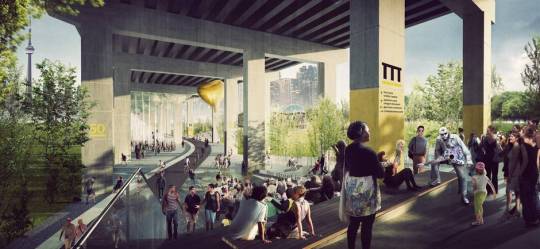
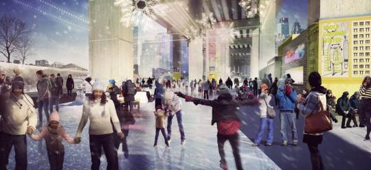
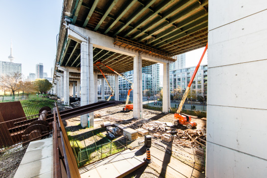
    And if we are stuck with it then we should make the absolute best of it – even celebrate it. Which is why Toronto is buzzing right now with the news that a 1.75 km stretch under the western portion of the Gardiner Expressway will be remade into a vibrant public space by 2017. This is thanks to a generous $25 million private donation. (Is that enough money?)

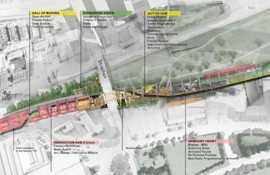
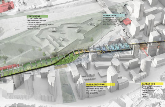
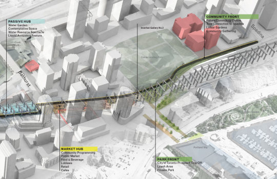
    Here’s the overall programming strategy, going from west to east (via undergardiner.com):

    imageimageimage

    And here are two renderings:

    imageimage

    The first phase is expected to run from Strachan Avenue in the west all the way to Spadina Avenue in the east. That is what is shown above.

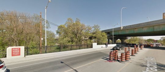
    Two key elements include a grand stair at Strachan Avenue, which looks like this today (via Google Streetview):

    image

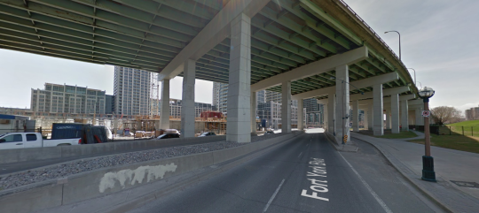
    And a pedestrian bridge over Fort York Boulevard, which looks like this today:

    image

    All of this doesn’t change my opinion of the Gardiner East, but I do believe that this is an incredibly exciting opportunity for the city. Today the space under the Gardiner is a void in our public realm.

    I also think it could be quite interesting to have these two opposing urban conditions along the central waterfront. A linear underpass park in the west and an open air boulevard in the east.

    It’s also exciting to see private money step up. It goes to show you that there is no shortage of passionate city builders in this town.

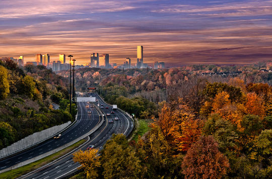
    Top image courtesy of Harry Choi Photography.

  • From map books to Google Maps

    When I was a kid I remember my parents having something called a “Perly’s” in their car. It was basically a map book and it was the best thing around. 

    You would start by looking at a big grid of the city and then you’d find the specific area you were looking for and then flip to that page. If you were on the road a lot for work, a Perly’s was a mandatory addition to your car.

    Things have obviously come a long way since then. It could take you a long time to find the street you were looking for in a Perly’s. I remember doing that from the passenger seat. Now our phones do that for us and if the connection makes us wait for more than few seconds, we get irritated.

    But we’ve also moved beyond just static maps. 

    The other morning I was driving out to the suburbs and I saw this road sign telling me that – given current traffic conditions – it was going to take me 15 minutes to get to HWY 427. 

    image

    Have you ever wondered how they come up with those time estimates?

    There are a few ways to do it. But here in Toronto along the Gardiner Expressway and Lake Shore Boulevard it’s done using your mobile phone. Phones have unique network identifiers called MAC addresses. And when they try and connect via Bluetooth or Wifi they actually send out their MAC address.

    So what happens as you’re driving along is that your phone’s MAC address is being picked up at various locations. And since the distance between these various reception points is known, it’s pretty easy to determine how fast you’re traveling. That’s how they come up with those time/traffic estimates. 

    This data is anonymous but, in theory, the city also knows if people are speeding when the traffic is light.

    This same technology is being used by many retailers and shopping malls to track how people move through their spaces. It’s used to see, among other things, which merchandising strategies are working and what synergies one might be creating (or not creating) with the tenant mix.

    But getting back to traffic, there are obviously ways to collect traffic data without any additional physical infrastructure.

    As I was about to leave the suburbs and head back downtown, my phone somehow knew I was about to do that (perhaps because I was stopped at a Starbucks near the highway) and so it decided to tell me this:

    image

    It wasn’t the best notification to receive on my phone, but I was impressed nonetheless. This traffic data is collected using GPS data transmitted from mobile phones using Google Maps, Apple Maps, and so on. Clearly we’ve come a long way since the days of manually leafing through a thick Perly’s.

    At the same time, it feels like we are still pretty far away from solving the problem of urban congestion. Every big city in the world is grappling with this issue

    Part of the problem, I think, is the belief that there’s some sort of silver bullet – more highways, a magic smartphone app, and so on – that will enable everyone to be able to drive around in their own car by themselves. I don’t believe that’s possible in big cities. And the sooner we get away from that toxic thinking, the quicker we’ll solve this problem.

  • How to save 8 minutes on Toronto’s highways

    City in Colour by Greg Patterson on 500px.com

    https://500px.com/embed.js

    Three months ago when Toronto City Council voted
    not to remove the Gardiner Expressway
    East (which in
    my view was a mistake
    ), it did so with a commitment to look at tolling
    options for both the Gardiner Expressway and the Don Valley Parkway (which in
    my view is a positive thing
    ).

    Last week a preliminary report was released
    discussing some of those tolling options. If reading dry city reports is your thing,
    you can do that here.

    The Coles Notes version (CliffNotes for you
    Americans) is that a $3 flat toll on both the Gardiner and the DVP – the same
    cost as riding transit in this city – would be expected to reduce vehicles on the highways by 9% and 12%, as well reduce end-to-end travel times by 3 minutes and 5
    minutes, respectively. There’s obviously a lot more in the report, but these
    figures stood out for me.

    Given how monumental the
    3 minute delay
    was in the Gardiner East debates, it will be interesting to
    see whether people treat a 3 minute time savings in a similar way. I suspect
    they won’t. The cost will be the larger issue.

    I’ve been a
    vocal supporter of tolls and road pricing on this blog
    . One of the main reasons
    for that is because I view the demand for highways as being largely inelastic
    and therefore a potentially great source of transit funding.

    The discouraging part of the above report is
    that its primary goal is to explore tolls for the purpose of “offsetting
    capital, operating, and maintenance costs.” The primary goal is not to come up
    with sustainable sources of transit funding.

    Having these costs paid for by user-fees as
    opposed to general taxes is still a good thing in my view. But an even better thing
    would be to help fund mobility solutions that we know will be far more
    effective at getting people around this region as millions more people move here
    in the coming decades.

    The other discouraging part of the report is
    that near the end it explains that while the City of Toronto Act of 2006 allows
    for toll highways, they cannot be implemented without the Province passing
    regulation.

    It’s a reminder that our governance structures do
    not reflect the current urban reality of this country.

  • 10 reasons to visit Toronto right now

    https://500px.com/embed.js

    Next weekend a good friend of mine from architecture school will be visiting Toronto from Philadelphia. And I’m really excited to show him the city. (Next month it’s my turn to go to Philadelphia.)

    He’s a fellow city geek. He hasn’t been to Toronto in a number of years. And I haven’t seen him since our trip to Detroit 2 years ago.

    For those of us living and working in Toronto, there’s a lot to celebrate. Sure the Gardiner Expressway East decision didn’t go as I – as well as many other urbanists, including our Chief City Planner – had hoped. But there’s no shortage of other things to brag about.

    So here are 10 reasons to visit Toronto right now:

    1. We’ve created an entirely new business district south of Union Station called South Core. Now the region’s primary mobility hub is in the middle of the country’s most important business district, as opposed to on the edge of it. It’s a better use of infrastructure.

    2. We now have a dedicated train (the Union Pearson Express) that takes you from the country’s busiest airport directly to downtown in 25 minutes. You’ll find local retailers at the stations and a brand created by the brain behind Monocle Magazine. You can even use a smart card to ride it and our local transit system.

    3. We didn’t shut down Uber. Instead our mayor wants to create new policy that will allow these services to coexist with conventional taxi services. We don’t yet know how this will turn out, but I believe it’s a step in the right direction. It’s Toronto taking a leadership approach to innovation as opposed to trying to stomp it out.

    4. We are about to host the largest sporting event in Canadian history. The 17th Pan American Games will have double the number of athletes competing as the 2010 Winter Olympics in Vancouver.

    5. We created an entire neighborhood from scratch in order to house all of these athletes (Canary District). And I think it’s destined to become one of Toronto’s great neighborhoods. I’m saving my first visit for next weekend, so expect a follow-up post on this.

    6. We are dramatically rethinking this city’s public realm. From the plaza out front of Union Station to the new Queens Quay Boulevard along the waterfront, we are prioritizing people and creating more complete streets. It has given Toronto an entirely new urban feel.

    7. We are slowly starting to embrace our forgotten laneways and alleys through the help of organizations like The Laneway Project. And this is going to eventually lead to a further rethink of our pubic spaces and urban fabric.

    8. We continue to be one of the fastest growing cities in the world (certainly in the developed world). As a result, we are building some really exciting buildings by some of the top architects in the world. This includes everyone from Norman Foster to Frank Gehry.

    9. According to a recent report coming out of the Martin Prosperity Institute, Canada is one of the most creative and globally competitive countries in the world, as well as the most open to “ethnic and religious minorities and gay and lesbian people.”

    10. The ATC community is in the process of identifying a new, quintessentially Toronto food dish. But since we have every type of imaginable cuisine here, we’re struggling to pick just one. When you visit, you can help us identify the best and most Toronto dish.

    So there’s a lot to be excited about. I for one can’t wait for us to host the Pan Am Games, starting tomorrow. It’s a chance to show off this great city. 

    So if you’re also in town next weekend and want to geek out about cities, drop me a line.

  • Gardiner East vote shows that Toronto is not yet ready to be an urban leader

    image

    Today is very sad day for Toronto. 

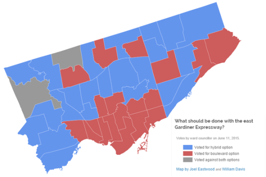
    After 2 days of debate, City Council voted this afternoon, 24-21, in favor of rebuilding the elevated Gardiner Expressway East (”hybrid” option) that runs along the city’s eastern waterfront.

    And once again, Toronto is largely divided. See above image prepared by Joel Eastwood and William Davis.

    It’s the old city of Toronto (who uniformly wanted the elevated highway replaced with a boulevard) versus the rest of the city (who for the most part voted for the hybrid).

    I can’t begin to tell you how deeply disappointed I am by not only the outcome, but also by how it happened and why it may have happened. For all of our talk about being a progressive global city, today we are clearly not that. 

    Because more than a vote on what to do with the Gardiner East, today was a vote on how we believe we should be building this city for the future. 

    When the Gardiner East was first built, the vision was one of fluid private mobility, where it would be possible to quickly circle around and across the city on an endless sea of highways. Detroit was doing it. Baltimore was doing it. Everybody was doing it.

    In other words, we were building our environment around the car. And our primary – some would say singular – focus was to ensure that the car could move unencumbered around the city. That’s why Toronto is now home to the busiest and one of the widest highways in the world.

    But despite all this, Toronto remains crippled by gridlock. And so does every other big city city in the world that has bet on cars as the solution. Why is that?

    Because that model doesn’t work.

    The I-10 Katy Freeway in Houston is 26 lanes at its widest point. It is the largest highway in the world by number of lanes. But from 2011 to 2014, commute times in some sections increased by as much as 51%. Is that because they haven’t built enough highway? How much is enough?

    By comparison let’s look at a city that has bet on transit as the solution: Tokyo. 

    The metropolitan area of Tokyo is approximately 37.8 million people. That’s more than the entire population of Canada and by most accounts is the largest urban region in the world. But despite its size, Tokyo is consistently ranked as one of the most livable cities in the world and also one of the most efficiently run.

    Interesting.

    So when I heard Councillors going on today about how a vote for the “hybrid” is a vote not to increase congestion and gridlock, it became abundantly clear that many – apparently most – people in this city still do not appreciate what it is going to take to get us efficiently moving as this region approaches 10 million people by 2041.

    This should not have been a debate about 3 minutes. That, as I’ve said before, is a red herring.

    Of course, there was lots of lip service to transit. Many seemed to agree that transit is the future. And some even went so far as to say that removing the Gardiner East and replacing it with a boulevard is the right thing to do, but that we simply can’t do it now because we haven’t made the requisite investments in transit. 

    If transit is truly what we want, then we why don’t we take the boulevard savings and put it directly into transit?

    To me it’s like saying: I really want to be homeowner, but I can’t afford it right now. So instead, I’m going spend more on rent so that I can burn through more money and make it even more difficult for myself to eventually become a homeowner.

    Because that is what happened today. 

    We voted to overspend on a stretch of elevated highway that is used by a small sliver of downtown commuters (~3%), instead of replacing it with a cost-effective surface boulevard (with similar road capacities) and then prioritizing the proven solution to urban congestion: transit.

    At the same time, we also made a number of other things clear in today’s vote. 

    We made it clear that cars matter more than our city’s public realm; that cars matter more than our waterfront revitalization plans; that cars matter more than our environment and our “efforts” to reduce GHG emissions; and, frankly, that cars matter more than our overall quality of urban life.

    I believe that cars will always be a part of our cities, but I don’t believe in putting them ahead of you and I. I guess old habits die hard. That my friends, really sucks.

  • Guest Post: Three minutes that rule the world – Will demolishing the Gardiner East actually make traffic worse?

    Today on Architect This City, we have a guest post by Darren Davis, who is a transport planner in Auckland, New Zealand. He’s a regular commenter on this blog, and I know he’s been following the Gardiner East debate quite closely – as many urbanists around the world are. I appreciate him offering and taking the time to write this piece. Thank you.

    ——————————–

    The decision this month on whether to demolish the Gardiner East Expressway and replace it with a surface boulevard or to rebuild it with a similar elevated structure will be a watershed moment for Toronto, akin to the decision not to have freeways in the urban core of Vancouver in the late 1970s.

    There are numerous good reasons why removing the Gardiner East elevated structure is the right move for Toronto, covered previously by The Globe and Mail and in the Council for Canadian Urbanism’s open letter to Toronto City Council. If you aren’t aware of these, I strongly recommend reading them. 

    Also of note are two things:

    1. Just 3% of Downtown commuters drive on the Gardiner Expressway East, a tiny fraction of the 68% who arrive Downtown on public transit.
    2. The “remove” option does not reduce traffic capacity over the “hybrid” option but could reduce travel speeds in uncongested conditions (read on for why I don’t think that this will happen in real life).

    However, one element of this debate that has not got much airtime is the transportation modelling that claims an additional two to three minutes travel time with the “remove” option over the “hybrid” option which retains the elevated expressway in a slightly modified form. 

    Toronto Mayor John Tory has stated that "I didn’t get elected to make traffic worse. And let’s be clear, removing that piece of the Gardiner will almost certainly make traffic worse.” But is it in fact true that demolishing the Gardiner Expressway East will make traffic worse as the transportation modelling claims?

    The key thing to understand is that transportation modelling, which tries to predict future travel times, is the product of a bunch of assumptions which may not in fact be borne out in real life. 

    For example, the effect of induced traffic, where additional traffic capacity leads to additional traffic being attracted to the route, is reasonably well known but generally not factored into transportation modelling. Induced traffic happens because increased travel speeds attracts traffic that would have otherwise avoided the route at congested times; attracts people to drive where they previously used other modes and encourages trips that would not otherwise have taken place. The effect of induced traffic is to quickly nullify the benefits of adding traffic capacity.

    However, what is less well known is that the reverse happens where there is either a reduction in traffic capacity (not the case in Toronto as the “remove” option retains the same traffic capacity) or speed.

    This is because in this situation, four things happen:

    1. Some travel re-routes. The “remove” option with a widened Lakeshore Boulevard as part of the street grid simply gives more ability for traffic to re-route away from congestion over an elevated expressway structure where drivers are literally trapped until they reach their exit.
    2. Some travel re-times. Some people will retime trips to avoid congested travel times, such as starting and/or finishing work at less congested times.
    3. Some travel changes mode. Some people will be encouraged to change mode by the perceived worsening in traffic conditions.
    4. Some travel is avoided entirely. Some people will choose not to travel at all in the peak of the peak. For example, this could take the form of working from home or shopping on the internet instead of by car.

    Transportation models only take into account the first item but not the others. The modelling is also sensitive to traffic growth assumptions and assumed mode split and trip distribution. Often transportation models assume continued growth in car travel even though per capita kilometres travelled peaked about a decade ago.

    While this may all sound well and good theory, does this actually happen in practice?

    In Auckland city centre, we have extensive experience with the reallocation of road space away from general traffic. Many busy key city centre approach routes have had general vehicle lanes reduced to make way for bus lanes (which generally carry around 65-70% of the people moving capacity of the street). 

    This has involved up to a 50% reduction in private vehicle capacity (whereas in Toronto, the “remove” option retains the same traffic capacity but may slow throughput). Auckland has done two of these in the past twelve months – both involved converting a general traffic lane to a bus lane. 

    Don’t get me wrong: There is sometimes pain at implementation with about a three week period of congestion as car drivers adapt to the new reality – and most likely negative media coverage will accompany this. But after about a month, equilibrium will be restored and life will continue much as it did prior to the change. 

    Part of this is that there will be various “optimisations” during this introductory period where signal timings are adjusted and other tweaks made – the sort of tweaks that can only be fine-tuned in a real world situation. But a bigger part of this is that the four factors above – re–routing, re-timing, mode change and avoided travel – come into play.

    I cannot overemphasise enough that life will return to normal surprisingly soon if the Gardiner East Expressway is demolished and replaced by a widened Lakeshore Boulevard.

    My advice

    When people talk about two to three minutes of extra travel time, take the foregoing into account and take those claims with the very big grains of salt that they deserve. If Toronto makes the right choice and chooses the “remove” option, my bet is that the biggest surprise of all will be how little difference it makes to peak travel times for the 3% of Downtown commuters who used to use the Gardiner Expressway East.

    Disclaimer

    The author of the above post is an employee of Auckland Transport, however, the views, or opinions expressed in this post are personal to the author and do not necessarily represent the views of Auckland Transport, its management or employees. Auckland Transport is not responsible for, and disclaims any and all liability for the content of the article.

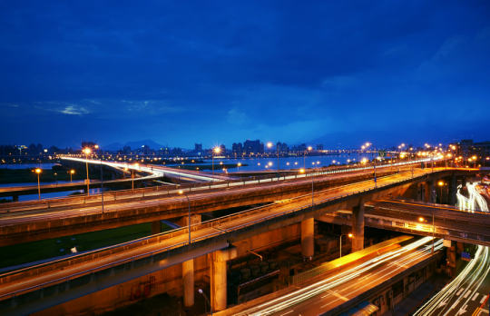
  • Top 10 freeways without a future

    https://500px.com/embed.js

    Last year The Congress for the New Urbanism (CNU), which is based out of Chicago, published a report called, The 2014 Freeways Without Futures. It listed the top 10 freeways across North America that are in need of removal, replacement, and revitalization. You can download the full PDF report by clicking here.

    Here’s an introductory snippet from the report:

    The 2014 Freeways Without Futures Report lists the top opportunities in North America for replacing aging urban highways with boulevards or avenues that connect to the networks of streets. They are presented in no particular order of rank. As in previous reports, the criteria for the 2014 list is based on a number of factors: the age and design of structures, redevelopment potential, potential cost savings, ability to improve both overall mobility and local access, existence of pending infrastructure decisions, and community support.

    And here’s the list of freeways without a future:

    1.  I-10/Claiborne Overpass, New Orleans
    2.  I-81, Syracuse, New York
    3.  Gardiner Expressway, Toronto
    4.  Route 5/Skyway, Buffalo
    5.  Inner Loop, Rochester New York
    6.  I-70, St. Louis
    7.  I-280, San Francisco
    8.  I-375, Detroit
    9.  Terminal Island Freeway, Long Beach
    10.  Aetna Viaduct, Hartford

    Not surprisingly, the Gardiner Expressway is on the list. CNU is in agreement with the “remove” option currently being contemplated by Toronto City Council and will be doing their part to support the Gardiner East petition that Stephen and I created. Thank you for that 🙂