Daily insights for city builders, delivered every morning at 6 AM ET. I’m Brandon Donnelly — a Toronto-based real estate developer and founder of Globizen. I’ve been writing here since 2013.

Tag: cities

  • Big cities have rebounded the fastest since 2008

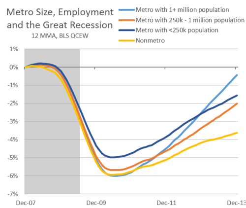
    Josh Lehner of the Oregon Office of Economic Analysis published a study earlier this summer where he looked at employment growth according to city size across the US.

    What he found since the Great Recession of 2008-2010 is that larger metros – with populations greater than 1 million people – have rebounded the fastest. They are shown in the light blue line below:

    According to Josh:

    This is at least partially due to the fact that all those good economic things — agglomeration effects, knowledge spillovers, clustering, etc — happen in certain locations, which are usually bigger cities.

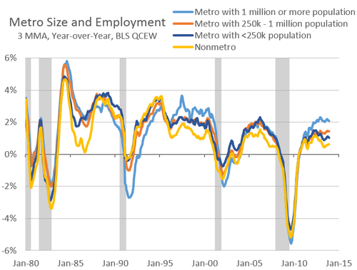
    However, if you go back to the 1980s, you find that this trend isn’t consistent. Large metros outperformed in the late 90s. But they were more or less on par with smaller metros during the housing boom of the early 2000s and actually under performed in the early 90s recession.

    One possible explanation for this – which Josh proposes – is that the recent housing boom acted as a sort of equalizer for smaller metros. It created stronger population growth outside of the bigger cities.

    I buy that.

    But then does that mean that going forward big cities will continue to outperform? Is this going to be more or less the new norm? Intuitively, I would think yes.

    You can find Josh’s blog post, here. Richard Florida also wrote one for CityLab, here.

  • Multi-modal cities are the new reality

    CityLab published an article last week on multi-modal cities that caught my attention (because it used a picture of Toronto with about 3 or 4 streetcars stacked up along Queen Street). The premise of the article is that all of this car vs. transit debate is actually missing the bigger picture: our cities are multi-modal and we need to be planning for that.

    That’s not to say that the shift away from cars isn’t a good thing. It is. But it’s not as simple as saying that, instead of driving, people should now only take transit. In today’s cities people walk, bike, take streetcars, take buses, take subways, take taxis, take private shuttles, use Uber, and, yes, they still drive.

    From my own experience, this is absolutely how I get around Toronto today. I walk to the gym. I ride my bike whenever I’m going somewhere downtown. I take the subway to my office in midtown because it’s far and I would be too sweaty if I biked there. I use Uber and Hailo when I’m going out at night. And I drive when I need to go to the suburbs or leave the city.

    But the key takeaway here is that we now have a much tougher challenge on our hands. When we were only optimizing for cars – however detrimental to our cities that was – we only had one mode to plan for. Now we have several. Some of which are public and some of which are private.

    However we also have access to technologies that we didn’t have before. We are networked in ways that weren’t possible before and we’re at the dawn of many profound mobility changes, such as driverless cars. (Have you read about Tesla’s new Autopilot feature yet?)

    So as I’ve said before, I really believe that we need to look at this, not as a war on the car, but as a war on inefficiency. The problem we are trying to solve relates to mobility: What’s the best way to move lots of people around dense urban regions? Stop focusing so much on the technologies and focus more on the people.

    Image: Flickr

  • How does your city address its streets — literally?

    image

    Depending on where you live, street numbering may not be something you’ve given a lot of thought to. In Canada, and in many other places in the world, the convention is usually to start on one end of the street and count up – with even numbers on one side and odd numbers on the other.

    In many cities in the US, they’re even more rational. The streets themselves are numbered and the addresses indicate location. For example in Philadelphia, where I used to live, if you were going to let’s say 1750 Walnut Street, you would know that it’s between the cross streets of 17th Street and 18th Street. It’s a kind of hyper-rational approach, which lets you know precisely the number of blocks you need to go to get to your destination.

    But not all countries and cities are this rational.

    According to this Economist article – which a friend of mine forwarded me over the weekend – Costa Rica actually had no street numbering system until about 2012. Which means that directions were all based on landmarks: “100 metres south of the McDonald’s.” It seems almost hard to believe. But I guess that’s why ¼ of all mail was getting lost.

    Of course, there are also lots of variations in between these two extremes.

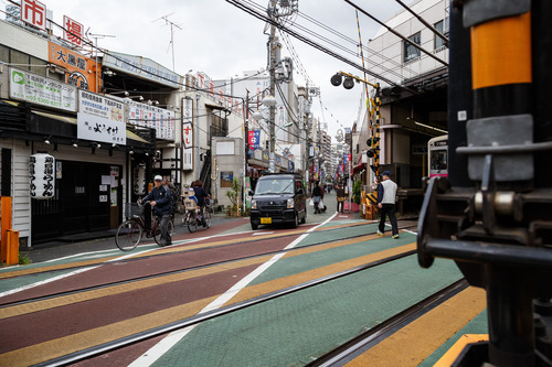
    Japan numbers its buildings, but they’re often clustered together in blocks and have no particular order or logic to them. Brasilia (Brazil) also assigns numbers based on sectors, quadrants, and blocks. And in Ireland, where I also used to live, they actually never adopted postal/zip codes. They’re one of the few developed countries in the world not to do that – though it’s coming next year.

    If your city or country has a unique numbering system or you’ve come across one in your travels, I would love to hear from you in the comment section below.

    There are obviously practical reasons to adopt an easy to understand numbering system. People need to be able to figure out where they’re going. But I would also imagine that there are spatial implications to the way you number and the way you organize your city.

    Image: Flickr

  • Assembled realities of the New York landscape

    New York photographer Jeff Chien-Hsing Liao has an upcoming solo exhibition at the Museum of the City of New York next month called Assembled Realities. I just heard about it through CityLab.

    Here’s a bit of background on his work:

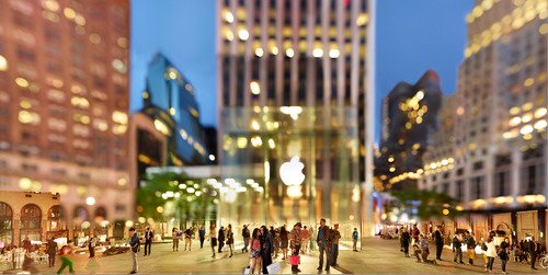
    Pushing the boundaries of traditional documentary photography, Liao (b. 1977) creates large-scale panoramas by combining multiple exposures of the same location taken over the course of several hours. The resulting composite photographs are often fantastical; complex, hyper-real views that no single shot—or the eye—could capture.

    And here’s two more of his photos:

    For higher resolution versions, click here.

    I love how his photos begin to distort reality and how they focus your attention – in many cases – on New York’s vibrant street life. I thought you might all enjoy them as well.

  • Fun Friday: Skateboarding city tours (Brisbane & Porto Alegre)

    Some of you told me that yesterday’s post on careers was actually quite sad. That it came across as if I were advocating for people, not to do what they love, but to instead do what makes them the most money. But that was not my intention. 

    There were a lot of reasons why I got into real estate development, and perhaps I oversimplified yesterday. But a lot of it actually came down to the fact that I’m passionate about building great cities (hence this blog).

    And I thought it was ultimately unfair that some investment-banker-turned-developer, who doesn’t really care about cities, might end up having more say over the built environment than me, the architect. 

    So I decided to sacrifice designing individual buildings in the hope that I’d one day be able to give back to cities on a much larger scale. And I still hope to be able to do that.

    In any case, to end the week on a more fun note, I thought I would do a post called Fun Friday and link to 2 city tours: one of Brisbane, Australia, and one of Porto Alegre, Brazil. 

    But these aren’t just any city tours. They are by local skateboarders showing you their city. I posted one for Toronto about 8 months ago, so some of you might be familiar with the series.

    I love how differently skateboarders look at the urban environment. I hope you can appreciate it as well. 

    Brisbane, Australia:

    [youtube https://www.youtube.com/watch?v=KEFQLjnhKT4?rel=0]

    Porto Alegre, Brazil:

    [youtube https://www.youtube.com/watch?v=taF71igPZY0?rel=0]

  • #ATHISCITY

    One of the things that makes cities so exciting is the fact that they’re always changing. New restaurants open up. New buildings are built. Old buildings (with no heritage value, of course) are demolished. Bike lanes are added. New infill homes pop up in quiet residential neighborhoods. And the list goes on.

    For years I’ve wanted an app or some sort of product that would allow city builders to keep track of everything that’s going on in their city. In the same way that Foursquare helps you find cool restaurants around you, I would like to know about everything that’s going on, from rezoning applications to construction updates.

    One of the challenges, of course, is that I’m sure more people care about cool new restaurants than about esoteric planning applications. It’s definitely a niche market. But that doesn’t mean there isn’t a thriving group of people who do care. So I’ve decided to introduce an Architect This City hashtag on Twitter: #ATHISCITY.

    I’ll be using it for city building updates and, if some of you join in as well, I think it could become a great way to keep track all of the neat things that are happening in our city, as well as in others around the world.

  • Does the world need a Global Parliament for Mayors?

    Earlier this month a team consisting of Benjamin Barber (who is author of If Mayors Ruled the World: Dysfunctional Nations, Rising Cities), Richard Florida (who is Director of the Martin Prosperity Institute here at the University of Toronto), and Don Tapscott (who is a leading authority on innovation) released a research report advocating for a global network of cities that they’re calling a “Global Parliament for Mayors.”

    Here’s a snippet from the press release:

    “Nation-states work together through multi-lateral agreements and global institutions in an effort to solve global problems. But states have limitations, and their cooperative efforts in our new era of interdependence and globalization are increasingly insufficient and even ineffective and outmoded,” say the three prominent researchers. A Global Parliament of Mayors represents a new type of governance network – one with enormous potential.

    “Our proposed parliament would operate as a global urban network with a vibrant online community that collaborates on key issues 365 days a year,” they say. “Multi-stakeholder governance has come of age and is now fully independent from control by any government, or governmental organizations like the UN.”

    And if you dive into their report, you’ll find the following 5 reasons for why they believe a Global Parliament for Mayors (GPM) makes sense:

    1. Global migration to cities. Most people live in cities, so it makes sense to concentrate problem-solving capabilities there.
    2. Urban predisposition for problem-solving. Cities are entrepreneurial, close to the people and richly connected to a wide variety of stakeholders. They have a history of cooperation and pragmatic problem-solving. 
    3. A need for experimentation with new governance models. Traditional models of state-based global governance have struggled to advance effective solutions to many global problems, so there is an urgent need to experiment with new models. The GPM is the most promising. 
    4. Digital networks. Online collaboration technology makes it possible to operate a largely virtual parliament that would not only be more cost-effective, but more transparent, inclusive and productive.
    5. Digital citizens. There is a large, educated and motivated population of digital citizens that could be tapped to improve urban governance.

    In principle, I agree with the direction. And I feel that way because of the two major shifts outlined above: More people are living in cities (a trend that all urbanists talk about ad nauseam) and digital networks are having a disruptive effect on the way we run companies and live our lives.

    I’ve talked before about how the internet is causing a decentralization of value creation (see Airbnb, YouTube, and so on) and so I think it only makes sense that our governance structures will inevitably go through a similar transformation.

    The governance models that we are living with today were put in place during a time when the world was a different place. At one point, nation-states were the de facto way to effectively organize ourselves on a global stage – probably because there wasn’t any other reasonable alternative.

    But today, we are connected and interdependent in entirely new ways. And so the opportunity in front of us is to create a governance structure that leverages the progress and innovation that’s happening in cities, everywhere.

    If cities are our most important economic unit, then mayors are arguably some of our most important leaders. So it behooves us to figure out how to give them the frameworks and forums to best do their job.

  • What’s in a neighborhood?

    image

    When I was working on my startup Dirt last year, one of the things we spent a bit of time figuring out was how to classify buildings according to neighborhood. Now, at first blush, this may seem like a fairly easy thing to do. You simply locate the building, figure out which neighborhood it’s in, and then tag it accordingly. But neighborhood boundaries and definitions aren’t as clear cut as you might think.

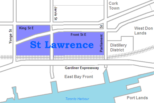
    For example, a lot of you probably know that I live in the St. Lawrence Market neighborhood of Toronto. And indeed, if you look at this Wikipedia definition, I live in that area. But if you look at what they call it, it’s just: “St. Lawrence.” They also specify that it used to be called “St. Lawrence Ward”, but that today most people actually call it “the St. Lawrence Market.” So here you have an example of an evolving and changing name.

    image

    But then there’s the question of boundaries. According to Wikipedia’s definition, the north boundary is Front Street. This means that the North Market Building would be technically outside of the area and so would the Market Square condos. But I suspect that almost everyone would consider these two buildings to be part of the neighborhood. So where exactly is the north boundary? Is it King Street? Or maybe by Front Street they mean that all buildings on the north side of the street are included.

    If you look at the city’s official neighborhood list (which is built from Statistics Canada Census Tracts) you’ll find a completely different boundary and name. According to this list, I live in the “Waterfront Communities–The Island” neighborhood. Obviously nobody, other than maybe somebody who deals with census data, would have any idea what this area is. But it’s how the city tracks its demographic data.

    What this begins to show you is that neighborhood definitions and boundaries aren’t as black and white as they might initially seem. And it’s partially because cities themselves are always in flux. New neighborhoods emerge and old ones reinvent themselves. And as that happens, people start introducing new names and new terminologies.

    image

    When I was about 19 years old, people in Toronto used to say they were going out “on Richmond and Adelaide.” Since then, gentrification has pushed many of the bars and clubs out of that area. So people instead go out “on King West” or “on Ossington.” And as people begin to use those terms and identify with an area, new brands are created. Ask anybody who lives downtown and I bet they’ll tell you that King West has its own unique personality and even a type of person who typically lives there. This is an on the ground type of awareness though, which doesn’t get captured in census tracts.

    The other reason neighborhood boundaries can be so fuzzy is because we – the real estate community – are constantly trying to manipulate them for our own benefit. I’m indifferent to the fact that this happens, but it is a reality. Think about how much the neighborhood of Yorkville has been stretched from its original roots north of Bloor Street. If a neighborhood has a good brand, agents and developers will naturally try and leverage it. Homeowners do it all the time too. Would you prefer to say that you live in Seaton Village or the Annex?

    Ultimately, we (my Dirt cofounder and I) decided that neighborhood definitions and boundaries needed to be fluid. They needed to dynamically adjust with the market and come from as many people as possible on the ground. Because at the end of the day if the official documents say one thing, but the majority of city residents believe another, then that official boundary and definition are probably out of date. The crowd wins here.

    We liked this approach because it was organic – just like cities.

    Images: Flickr, Wikipedia, Flickr

  • Put your window to work and make $50 a month

    image

    I’m convinced that city building – like probably every other industry – is going to get a lot more data driven. Yesterday I wrote about how driverless cars are collecting exact replicas of our cities as a result of the 3D scanning that they do. And today I learned about an interesting new startup called Placemeter.

    Basically it works like this: If you have a window (at home, at the office, or wherever) that faces onto a lively street, Placemeter will pay you to setup a smartphone in that window as a “meter.” The going rate is up to $50 per month and they’ll even provide you with the necessary suction cups.

    Through video, your phone will then start collecting anonymous data about that street’s activity levels: the number of people, cars, and so on. Below is a video of what that output looks like. Notice that it’s even collecting the number of people that go into each of the stores. Click here if you can’t see the video below.

    //player.vimeo.com/video/69091237

    To make money, Placemeter plans to sell (or is already selling) this data. And their goal is to “make your city better” by specifically improving the way that pedestrian spaces are designed. There are of course lots of other use cases for data like this (such as seeing how busy that bar is across town), but their primary goal appears to be around city building. At least that’s the case right now.

    Not surprisingly, there are concerns about privacy. But I’m sure they’ll be able to work around that. All of the data they collect is anonymous and they don’t save any of the footage that they receive from the meters. Their system just extracts the relevant data points and then automatically deletes the video. 

    What’s also interesting to me about this startup, though, is that it’s yet another example of decentralized value creation. Just like Airbnb empowered anyone with a spare room to run their own bed and breakfast and YouTube empowered anyone with some talent (or a funny cat) to create engaging content, Placemeter is allowing anyone with a window and a view to connect and contribute to a network of urban sensors.

    And it works because the marginal cost of adding a new meter to their network is relatively low. Especially if you compare it to what it might cost for a municipality to setup and manage a similar – albeit centralized – system. It’s a totally different cost structure. So when we talk about smart cities and data driven city building, we’re really talking about networks and an environment of decentralized inputs.

    It’s a pattern that keeps coming up as a result of the internet. If you start watching for it, I’m sure you’ll see it.

    Image: Flickr

  • 5 ways in which you’ve got it wrong when it comes to cities

    About a month ago, a reader of ATC and friend of mine suggested that I write a post on some of the common misconceptions that people hold about cities. I immediately thought it was a good idea and so I started a draft post with some of my initial thoughts.

    Over the past couple of weeks I’ve been collecting fallacies as they came to me, waiting until I reached a nice round number like 5. Well today, I reached that number. So here are 5 misconceptions that I think people often hold about cities. If you have any others, or if you disagree, please share your thoughts in the comment section below.
    1. Adding more lanes will solve traffic congestion

    There’s a saying I read somewhere: Adding more lanes to solve traffic congestion is like loosening your belt to deal with obesity. I can’t remember where I read it, but I like it a lot because it gets at the heart of this fallacy: Trying to build our way out of traffic congestion has proven time and time again to be a losing battle. In fact, it has been shown to make traffic even worse as a result of “induced demand.” The more roads you build, the more people drive.

    2. A suburban home is always cheaper

    While it is true that the direct cost of a suburban home is usually less than one in the center of a city, many people often neglect to factor in the indirect costs of a home purchase – the biggest of which is usually transportation costs.

    As you move out from the center of a city and home prices start to fall, I like to think of it as transfer from housing costs to transportation costs. In other words, what you save on the price of your home, simply gets used to pay for a car (or perhaps a second car), as well as the additional time you’re going to spend traveling.

    So how much is an hour of your time worth? Have you ever attached a value to it and added it to the price of your home? Because if you factor in transportation costs and your time, you might find that your suburban home is actually more expensive.

    3. Opposing new development and advocating for affordable housing is a responsible way to build cities

    Community opposition is a big part of the development game. But what a lot of people don’t think about is that when you oppose or stop new development (let’s say it’s residential), the demand for that housing doesn’t go away. 

    In fact, all it does is create more pressure on the housing stock that does exist and foster an environment where the rich will starting outbidding the poor for housing. More simply, you end up creating a supply constrained market and that drives up home prices. Demand > supply. So in reality, opposing new development and, at the same time, advocating for more affordable housing is a contradiction.

    As a comparative example, let’s think about another basic human need: water.

    Imagine that you could only buy water from stores (it didn’t come out of taps). But that every time the delivery people were trying to bring more water to these stores, that there was a group of people who fought and opposed them. These opposers already had enough water for themselves and they didn’t want additional water being sold as it would bring new customers into their local grocery store and disrupt their way of life.

    This, of course, caused the price of water to rise as the rich people started offering more for the water. This in turn made it difficult for the poorer folk to afford any water at all. But instead of allowing the delivery people to simply deliver more water, it was decided that out of the water that they have, that some of it should be earmarked as “affordable water” and priced accordingly. That would guarantee that the poorer folk could still have some.

    Does that sound like a sensible solution to you?

    4. Developers don’t want to build big apartments

    Here in Toronto there’s a somewhat pervasive belief that developers don’t want to build big condo and apartment units. The thought is that small units are more profitable and so developers are doing everything they can to squeeze people into small units. But I’ve argued before that this isn’t the case. It’s far more nuanced than that.

    To illustrate this point, imagine you’re a developer debating between building two 500 square foot condo units or one 1,000 square foot condo unit. If you build the two 500 square foot condo units you’ll need 2 x kitchens, 2 x entry doors, 2 x separate color selection appointments, 2 x separate PDI appointments, and you’ll have to pay development charges on two 1 bedroom units (to name only a few things).

    On the other hand, if you build one 1,000 square foot condo unit you’re only going to need 1 of each of the items listed above and you’ll be paying development charges on only one 2 bedroom condo unit (which currently works out to be less than what you’d be paying for the two 1 bedroom units – it’s not quite double).

    Which one do you think would be cheaper to build?

    5. Technology is going to make cities irrelevant

    Lastly, during the dot com era there was a growing belief that technology and the internet were going to make cities and real estate irrelevant. Capital was flowing out of real estate and into tech companies, because that was seen as the future. Bricks and mortar were passé.

    But since then we’ve learned that it’s actually the opposite. Paradoxically, technology has made cities even more important. The returns to being smart and talented are huge in the right place. So much so that our biggest concern shouldn’t be whether cities are going to become irrelevant, but whether we’re concentrating too much wealth and talent in only a select few.

    So there you have it, 5 misconceptions about cities. I’m sure there are many others, so I’d love to hear from you in the comment section below.