Daily insights for city builders, delivered every morning at 6 AM ET. I’m Brandon Donnelly — a Toronto-based real estate developer and founder of Globizen. I’ve been writing here since 2013.
Architect Bjarke Ingels recently gave a talk at the WIRED by Design conference. I’m a big fan of his work and so I think you’ll really enjoy the talk. What I like is how process driven his firm is. As he explains at the beginning of the video, they always start by researching and analyzing the situation before figuring out how they’re going to intervene. That’s what informs their designs.
Click here to watch the video. It’s about 20 minutes long.
A few days ago I wrote a post talking about what happens when you demolish an urban highway. It was a link to an article giving 5 examples of cities that have removed their urban highways and benefited.
After I wrote the post, a number of people responded on Twitter. Some thought it was a great idea and gave examples of other cities, such as Detroit, that are thinking about doing the same. But others responded and said that I was out of line. And that while it might work in some cities, it simply isn’t a viable option in cities like Toronto.
So as somebody who believes we should be taking down the Gardiner Expressway, I thought it would be worthwhile to revisit the topic and provide a bit more information.
To be clear, I’m not suggesting we remove the Gardiner and replace it with nothing. My belief is that we should replace it with a broad surface street that would still move lots of cars, but that would make our waterfront much more open and accessible to everyone.
So how is this feasible?
Again it comes back to the concept of induced demand. Back in 2009, two economists from the University of Toronto and University of Pennsylvania – which are actually both of my alma maters – published a study called The Fundamental Law of Road Congestion.
In it they discovered something really fascinating: there’s a near perfect relationship between new roads and highways built and the total number of miles driven. In other words, as cities increased road capacities (during their study period of 1980 to 2000), the amount of driving went up just as much.
What this should tell you is that trying to build your way of out road congestion is usually a losing proposition. That’s why every large city has a traffic problem. Try and think of one that has solved this. And as much as it might seem intuitive to tell people at cocktail parties that your city simply needs to build more roads and highways, it’s typically not that simple. (In my view, the solution is road pricing.)
The other really interesting thing that this study revealed is that it works both ways. When you reduce road capacity, drivers start to disappear. People choose to live closer to where they work. People choose transit. People go into the office at different times. People make all sorts of different decisions in response to this road change, just as they do when there are more free roads available to them.
So within a reasonable band (obviously you can’t remove all roads), there is no perfect amount of road capacity. If you added another lane to your highway, it would be full. If you took away a lane, it would end up equally full. That’s why removing the Gardiner Expressway isn’t lunacy.
Instead, it actually makes a lot of sense:
It’s the cheapest solution (compared to repairing it or burying it)
It would free up money for transit and other mobility solutions
It would make our waterfront more open and accessible
It would beautify our downtown
It would increase land values all along the waterfront
And since we’re still in the early days of developing our eastern waterfront, now is the time to do it. The longer we wait, the harder it’ll get and the more expensive it’ll get.
So I hope that the leaders in this city will think long and hard about this as opposed to immediately assuming we need an elevated highway to keep this city moving. The last time I checked, it doesn’t work so well in its current state.
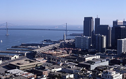
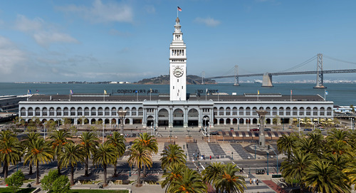
Images: Before and After the Embarcadero Freeway in San Francisco (via Gizmodo)
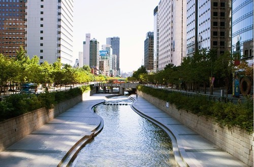
It’s a link to an article talking about 5 cities – New York, Milwaukee, Seoul, Portland, and San Francisco – who all demolished an elevated highway that used to run through their downtowns.
To be completely fair, some of these cities didn’t really have a choice. San Francisco’s Central Freeway was so badly damaged in an earthquake that it had to be closed. But it doesn’t make the lessons any less relevant.
In all of these cases, the elevated highways were taken down and never replaced with another highway. Some were turned into large boulevards. Others were turned into parks. But in none of the cases was a new road of similar capacity built.
Intuitively it might seem like this would cause utter chaos. I mean, where were all of these cars going to go?
But that didn’t happen. Instead, demand redistributed itself. Car volumes dropped dramatically. More people took transit. Some people took other routes. And some people traveled at different times. Oh, and nearby property values all went up.
And the reason this happened is because of something that economists call induced demand (I’ve written about it before, here). What it means is that as you increase the supply of some valuable good (such as free highways), more of that good becomes demanded.
In other words: more free highways = more cars on the road.
So if you’re a city – like Toronto – with an elevated highway running through your downtown, you should give this some serious thought. The outcomes aren’t as bad as you might think. In fact, they’re quite good.
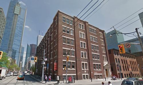
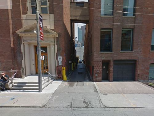
The property sits at the southeast corner of Adelaide Street West and Duncan Street (shown above), and includes an existing 61,911 square foot (GLA) office building, 36 surface parking spots, and a laneway (it was specifically called out in the press release).
The plan is to restore the existing heritage building, as well as build additional retail space, office space, and rental apartments. Given the nature of this site and the team behind it, I have high hopes that it will end up a remarkable development project.
It’s interesting to see the continuing interest in rental apartments here in Toronto – which is something I’ve written about before. Up until recently, the development community had almost zero interest in purpose built rental apartment buildings. Now they’re coming back in fashion.
But the other piece that’s interesting to me is the laneway. Below is a photo from Google streetview, showing what I believe is the laneway that the press release is referring to.
As many of you know, I’m involved in a non-profit here in Toronto called The Laneway Project (advisory role only). We want to transform Toronto’s underutilized laneways. And this strikes me as a perfect opportunity to do something really exciting at the corner of Adelaide and Duncan in the Entertainment District.
So if the new owners have any interest in things that are exciting, I would encourage them to get in touch with me or one of the founders of The Laneway Project.
Earlier this week Richard Florida published on article on CityLab talking about the relationship between tech innovation (in cities) and inequality. Specifically, the article deals with the correlation between venture capital investment and a variety of factors, such as monthly housing costs, wage and income inequality, and so on.
The intent of the piece was to address the growing backlash against tech workers – in places like San Francisco – who have become the symbol for the growing gap between the rich and poor.
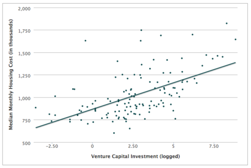
The strongest correlation appears to exist between venture capital investment and housing costs. As the amount of venture capital goes up, so do housing costs – which probably shouldn’t surprise you. The rich start outbidding the poor for housing. Note: The two outlying dots at the top right, in the graph below, are Silicon Valley and San Francisco.
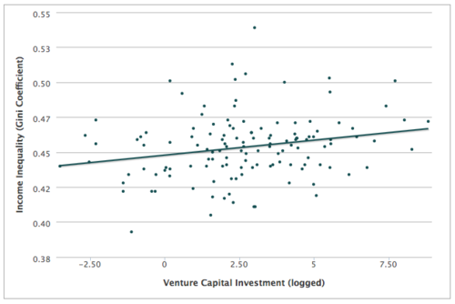
But when it comes to inequality, the relationship isn’t so clear. For wage inequality, there seems to be a relationship. But for the broader income inequality measure, the relationship is fairly weak. Here’s the graph:
So this is not as black and white as it might seem. Regardless, Florida ends the piece with the following statement (that I think is spot on):
It’s time to stop pointing fingers and get on with the far more important task of harnessing the urban tech revolution to create a new urban middle class and a more inclusive urbanism—one in which many more workers and residents can participate, and one from which many more can benefit.
The answer is not to stop innovating. That would be counterproductive. We should be be encouraging innovation, but at the same time figuring out how best to harness it for society as a whole.
Tomorrow, I’ll touch a bit more on how we might go about doing that. I have a post planned that I think will tie in really nicely to this discussion. So stay tuned.
Yesterday Opendoor.com finally launched their product in Phoenix. If you’re a regular reader of Architect This City, you might remember that back in July of this year I wrote about how they had just raised $10M of funding to make selling your home as easy as a few clicks.
Well, since then, I’ve been following them like a hawk. I had all the founders on Twitter notification (so I got notified every time they tweeted) and I was eagerly anticipating their launch.
Now that they’ve launched, we have a much better idea of how their business model is going to work. I say “better idea” only because there’s still portions of it that are a question mark for me.
In any event, Opendoor basically provides instant liquidity to homeowners. You go on, tell them about your home, and they then make you an offer to buy, which looks like this and lasts for 3 days. The offer they make you is calculated using comparable sales and adjustments based on your home’s unique characteristics.
Upon accepting their offer, they then schedule a home inspection (at their cost) to confirm your home’s condition. Once this is done, you just select your move out date and Opendoor handles the rest. The fee for all this is 5.5%, which the company claims is less than the 6% that realtors typically charge (this would be high for Toronto).
After buying your home, Opendoor plans to turn around and resell it.
What this reminds me of is a “bought deal.” In the world of investment banking, a bought deal is when the bank itself agrees to buy the entire offering of a particular security, as opposed to going out to the market and trying to raise the money. The advantage to the company (offering the securities) is that there’s no financing risk. They know they’re going to get their money. But it usually means the company gets a lower price.
So what I wonder, is if this is what’s going to happen here. Since Opendoor is effectively taking on the selling risk, does that mean their offers will be lower? Or are all their costs built into that 5.5% and that’s truly their core business model? I’m sure some of this will surface in the coming weeks.
I do, however, think they are smart to be focusing on the supply-side of the marketplace and offering virtually perfect liquidity to homeowners. Real estate is a unique asset in that it’s difficult to bring supply to the market. And so if control the supply-side, I think you have a pretty good shot at controlling the market as a whole.
The Economist recently published an essay called, A Planet of Suburbs – The world is becoming ever more suburban, and the better for it. The argument is basically that the “great urbanization” that everyone loves to talk about these days is actually a misnomer. From Chicago to Chennai, it’s not the urban core that’s growing. It’s the suburbs. And so what we’re seeing should actually be called the great suburbanization.
The basis for this argument is that wealth fuels sprawl. As people become richer, they naturally consume more of everything – including space. It’s a natural market outcome.
Take for example, the path of many of Toronto’s ethnic groups. In the first half of the 20th century, College Street was the Little Italy. Then it shifted north and St. Clair Avenue West became the more authentic Little Italy. Today, many Italians now live north of the city in Woodbridge. In fact, last weekend I was on St. Clair West and was disappointed to learn that one of my favorite butchers had closed up shop and “moved to Woodbridge.”
However, there are also many supporters of the exact opposite outcome. From Edward Glaeser to Alan Ehrenhalt, many have argued that we’re in the midst of a “great inversion.” The suburbs are no longer a threat to urban centers. It’s the urban centers who are threatening the suburbs. The suburbs are dead. Long live the city.
So which is it?
Well, The Economist does cite two examples where true urbanization is actually taking place. It’s happening in Tokyo and London. In both cases, it’s the city center that is growing the fastest – not the suburbs. The explanation for Tokyo is its aging population. And the explanation for London is its restrictive greenbelt, which effectively stops the possibility of any further sprawl.
Here in Toronto – where there is also a greenbelt in place – we know that the population of the downtown core is growing at an incredible pace. A recent report by the city – called Comprehensive to the Core – revealed that the downtown core is growing at 4 times the rate of the rest of the city.
But what about the suburbs?
If we look at the province of Ontario’s growth projections, it is indeed the suburbs which are expected to grow the fastest up until 2036. Here is a diagram showing percentage growth rates:
In absolute numbers, the city of Toronto alone is expected to add about 0.66 million people between 2012 and 2036, and the suburbs are expected to add almost 1.9 million.
There are a number of potential explanations for this differential, but I think it’s largely because land is cheaper in the suburbs, it’s easier to add new housing supply, population densities are lower, and we’re talking about very different land areas.
The city of Toronto is 630 square kilometers. If you tack on the suburbs, the Greater Toronto Area is 7,124 square kilometers. That means Toronto makes up less than 9% of the total land area. And yet it is expected to contribute 25% of the region’s population growth.
Still, the suburbs are where the bulk of the population growth is expected to happen over the coming decades.
However, the “great inversion” that authors like Alan Ehrenhalt have been talking about should not really be interpreted as the death of the suburbs. What he’s instead talking about is a socioeconomic or demographic reversal: center cities used to be poor and now they’re becoming rich.
What we are seeing is a reversal in which the words “inner city,” which a generation ago connoted poverty and slums, [are going to mean] the home of wealthier people and people who have a choice about where they live, and the suburbs are going to be the home of immigrants and poorer people. And Census figures show that that’s taking place.
In this context, we are still living through the great urbanization. We’re seeing a shift in consumer preference and a shift in where wealth is choosing to locate. That’s a profound change.
And while we’re obviously still suburbanizing, I don’t agree that we’re better for it. In fact, left unchecked, this demographic inversion could actually prove to be quite damaging to our suburbs.
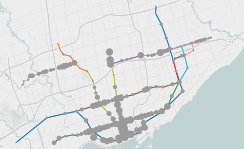
The map shows all existing, planned, and proposed transit lines in the city, and then overlays population densities, commuting patterns, household income, and so on. It’s a super valuable map that I think reveals a lot about how we should be focusing our energies to get Toronto moving.
So what sorts of things does it tell us? I’ll give 2 examples.
If you look at commuting patterns across the Bloor-Danforth subway line, you’ll see that Runnymede station in the west is where people switch over from taking transit to driving. People west of that station tend to drive. Naturally, it also happens to coincide with where population densities start to fall off.
By contrast, if you look at the east side of the city along the Danforth and beyond, the entire stretch more or less relies on transit to get around. Part of this likely has to do with income levels, but it’s also because of the availability of the Gardiner Expressway. There’s no equivalent in the east end. Dylan Reid of Spacing Magazine believes this makes a case for some sort of road pricing along the Gardiner, and I would agree.
As a second example, look at the population densities along the proposed Downtown Relief Line, Finch LRT, and John Tory’s SmartTrack line. Outside of the core, the population densities are relatively low along the proposed SmartTrack line – which is never a good thing for rapid transit.
There’s also no Sherbourne station on the SmartTrack line, which happens to have the highest population density across the entire Relief Line – 22,131 people per square kilometre! That’s more than any other stop along the Yonge-University subway line except for Wellesley station.
I’ve written about this a lot before, but I think we need to do a better job of matching up transit investment with expected customer demand. Too often we let politics get in the way of rationale decision making. Maybe it’s time we did something like set minimum population densities. If you want a subway line in your area, you have to first bring the people.
Two weeks ago I gave a brief presentation at The Laneway Project’s inaugural summit here in Toronto. I then wrote about it here on ATC.
At the time, I wasn’t sure if the event was being filmed or not, but it turns out it was. So here is my presentation from the event. It’s just over 7 minutes. Click here if you can’t see it below.
If you’d like to see the other 5 presentations and the Q&A session, click here.
Following the event, I was also interviewed by a radio show out of Calgary called Space + Place. If you are really into laneways and would like to listen to that as well, go here.
I’ve said this before, but I’ll say it again: I continue to be amazed by how much interest there is — both here in Toronto and elsewhere — in laneways. They may be overlooked today, but that’s going to change. It’s inevitable.
A few weeks ago I wrote about showcasing the Architect This City community. The idea was that there are lots of interesting and talented people who subscribe to this blog, but that there’s no scalable way for me to connect with everyone.
So I wanted to provide an opportunity for you to share a bit about yourself on this blog. I could selfishly learn more about the kinds of people who read ATC; you and/or your company could benefit from a bit of exposure; and you all could get the opportunity to connect with one another.
I didn’t get quite as many responses as I thought I would — which is partially why it has taken me so long to write this post — but I did get a lot of positive feedback on the idea. So I’m excited to share 5 of the people and companies that did respond.
Darren Davis @ Auckland Transport (Auckland, New Zealand)
Proudly car-free Principal Public Transport Planner, and arch transit nerd, at Auckland Transport. Auckland Transport is in the midst of the biggest redesign of the city’s public transport system since the introduction of electric trams in 1902. We are taking a once-in-a-generation opportunity to reimagine public transport by going back to first principles, in an exercise inspired by Human Transit and strongly influenced by its author, Jarrett Walker.
We are a consulting engineering practise — structural, building envelope, restoration, and special projects & renovations — bringing together engineering and intuition to enhance building performance. Entuitive is creative, collaborative, and advanced.
Taya Cook, Development Director @ Urban Capital (Toronto, Canada)
We develop forward thinking condominiums with a focus on urban location, fantastic design and superior customer experience. I work there. Really B, do you need more reasons for awesomeness?
Currently managing a Europe-wide €4m ERDF funded project, ‘Stimulating Enterprising Environments for Development and Sustainability’ (SEEDS). SEEDS is working with 8 partners across 6 countries towards establishing acceptance of the temporary use of abandoned places and spaces as an integral part of longer term planning.
Urbanspace Gallery is a unique venue, dedicated to diverse exhibitions and events that explore how cities work and how we might improve them. Our purpose is to present issues related to community, public space, housing, transportation, planning, governance, and sustainability (among others) in order to further the discussion about our own city and others around the world, while fostering a space of learning and reflection.
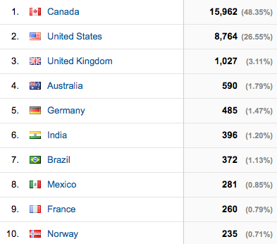
Most of the people who responded were from Toronto and Canada. And that’s not surprising given how local a lot of my content is. Half of the ATC reader base is currently from Canada.
But I did also get emails from many other places all around the world. It always amazes me to see where people are reading from. My only wish is that I could learn more from them (you). So drop me a line. I hope to do another community profile sometime soon.