Daily insights for city builders, delivered every morning at 6 AM ET. I’m Brandon Donnelly — a Toronto-based real estate developer and founder of Globizen. I’ve been writing here since 2013.

Tag: bike lanes

  • New York City proposes a bounty for reporting bike-lane blockers

    The general rule when it comes to bike lanes is that, if you build them without some sort of grade-separation, at some point a car is going to park in them. But here are two possible solutions to this problem. The first is that you could build some sort of grade-separation that can’t be driven over. And the second is as follows:

    Now a New York City Council member is pushing a bill that would give civilians the power to report bike lane scofflaws, as well as vehicles that block entrances or exits of school buildings, sidewalks and crosswalks. New Yorkers who submit evidence of a parking violation can earn 25% of a proposed $175 ticket. The Department of Transportation would review the evidence to determine whether an infraction has occurred, according to the bill’s text.

    What this essentially does is decentralize rule enforcement by paying people to be rats. Off hand, I can’t think of any other cities that have done something like this and so I don’t know how effective it might actually be. But being a rat sounds like it could be a good paying job.

    Let’s assume that somebody decided to treat this as their full-time job and work 8 hours a day, Monday to Friday. And then let’s assume that they were able to rat out one person per hour. Here’s how much money they could make in a year:

    • $175 x 25% = $43.75 per illegal incident
    • $43.75 x 8 incidents per day = $350 per day
    • $350 per day x 5 days a week = $1,750 per week
    • $1,750 per week x 52 weeks = $91,000 per year

    Now, if the goal of this rat-people-out program is to ultimately change behaviors, then it might make sense to assume that your revenues would decline over time as more people start following the rules. Either way, something tells me that more than a few people would be happy to take on this job.

  • Casey Neistat needs to make a YouTube video about cycling in High Park

    I love High Park. It’s the second largest green space in the City of Toronto and right beside the Junction neighborhood. But there are some problems. Despite having a subway line on its northern boundary, we’ve gotten the built form along its edges all wrong.

    There’s very little functioning retail. The densities and heights are not nearly high enough. The streets aren’t great walking streets. And we’ve even gone and created undignified bus stops like this one here.

    On top of all this, we’re now doing this silly thing where police are ticketing cyclists for riding around the park with too much vigor and enthusiasm. I’m sure somebody called to complain and this is all reactionary politics, but an even bigger reaction has now been set off.

    For those of you who haven’t been following or aren’t from Toronto, hundreds of cyclists took to the streets this week to peacefully protest what has been going on in High Park.

    The Globe & Mail then followed it up with this important piece calling for an end to cars inside the park. The boundaries currently house about 5 km of roads and almost 600 parking spots.

    Given all this, I figured now is probably a good time to revive one of Casey Neistat’s original YouTube videos called “bike lanes.” The story is that he gets a ticket for not riding in a bike lane. And so he films a video of himself only riding in bike lanes — even if there are obstacles in his way.

    It’s an awesome video with nearly 30 million views. And I’m sure that many of you have felt like doing exactly what he does when faced with this same situation. I know I have.

  • Paris vs. New York bike lanes

    It’s one thing to have bike lanes. And it’s another thing to have really generous bike lanes. The above video by Streetfilms does a good job of comparing Paris to New York City, and showing just how far Paris has come in terms of cycling infrastructure. Some of you might remember that in the fall of last year, Paris announced plans to become a “100% cycling city.” This was a follow-on to their plan vélo 2015-2020, which saw a doubling of the city’s bike lanes. The current plan, which covers 2021-2026, includes 130 km of new bike lanes and 52 km of pandemic lanes that have been (or will be) made permanent. But again, it’s one thing to have a lot of bike lanes. And it’s another thing to have a lot of wide bike lanes that look like the ones in this video.

  • Paris announces plan for “100% cycling city”

    Paris just announced plans to become a “100% cycling city.” A follow-up to plan vélo 2015-2020, which saw a doubling of the city’s bike lanes, plan vélo 2021-2026 includes 130 km of new bike lanes and 52 km of pandemic bike lanes that will now be made permanent.

    In addition to cycling lanes, the plans include new bike parking, new transit integrations, and a bunch of other things that are meant to strengthen the overall ecosystem in the city. The total budget for this second plan is about €100 million, which will bring the total cycling investment over the last 10-11 years to about €250 million. This is a serious commitment to cycling.

    It’s also a good example of one of the things that we have been talking about on this blog. This pandemic forced us to rethink how we allocate urban space — everything from outdoor restaurant patios to bike lanes. And as we can see here, many of the positive changes are not surprisingly starting to stick.

  • The 10 commandments of micromobility

    This is a great 30 minute talk by Horace Dediu that is structured around his 10 commandments of micromobility. If you can’t see the embedded video above, click here. What I think that many of you will appreciate about the talk is that he focuses on smaller interventions. Think bike lanes over big hyperloop moonshoots. In his words, we’re going to get to where we want to go not through hyperbole, but through humility. And micromobility is all about humility.

    I’m also a big fan of his last commandment. It is titled: cities always win. Yup.

  • Toronto approves 40 km expansion of cycling network

    This week, Toronto City Council approved the largest ever one-year expansion of bike lanes in the city — a total of 40 km. It passed 23 to 2. Here is a map of the approved routes:

    The Bloor West extension is being accelerated. This will take the Bloor Bikeway out to Runnymede and High Park in the west (close to our Junction House project).

    New expansions of the network in the core include Bloor Street East, University Avenue, Dundas Street East, and Danforth Avenue (which also happens to connect another one of our development sites on Dawes Road).

    Bloor, University, and Dundas are expected to be among the first installations. The idea here is to have them mirror some of our subway lines and fill the mobility gap as many people shy away from transit in the short-term.

    All of this wouldn’t have happened without COVID-19, at least not this quickly. I’m certainly not happy about a pandemic, but as a car owner and fair-weather cyclist, I am happy about these new bikeways and I am happy that we were compelled into action.

  • Adelaide cycle tracks

    Earlier this week I was on Adelaide Street (Toronto) for a morning meeting. This is further north than my typical routine.

    For those of you not familiar with Toronto, Adelaide is a one-way street with separated bikes lanes. These “cycle tracks” were installed as part of a pilot project that launched back in summer 2014. As I’m sure you can imagine, they were highly controversial at the time. Many heated debates.

    But if you stand on Adelaide Street during the morning rush, as I did earlier this week, I think you would be amazed to see just how widely used these lanes actually are. Here’s a video of Adelaide (just east of Spadina) in action. It is by Gil Meslin and was filmed sometime between 840 and 855am on a weekday.

    However, I will say that I was far more impressed by the volume of bikes I saw in person. I wish I took a picture. They easily outnumbered the cars when I was there, which speaks to the latent demand for this sort of infrastructure. I can’t imagine a faster way to get across downtown in the morning.

    So if you haven’t already, check out Adelaide (or Richmond Street, which is also part of the cycle tracks program).

  • Form follows parking

    “Form follows function” is a famous axiom of 20th century Modern architecture. It is based on the rational notion that architecture and its associated shapes, geometries, and spaces should be a direct result of their function. 

    It was a way of trying to eliminate the arbitrary ornament that had adorned previous architectural movements. In this case, if it had no function, then it should be stripped away.

    There have been many bastardizations of this pithy statement over time, but one of my favorites is: “form follows parking.” Obviously derogatory, it is this idea that much of the built environment is a result of parking requirements, rather than of more human factors.

    We see this in suburban building typologies (large surface parking lots), but also in urban infill projects where the below grade parking begins to dictate the structural grid and layout of the upper floors. It is, of course, necessary in many cases, but there’s also something subversive about parking having such a lasting impact on the spaces we occupy.

    That said, we know where the trend line is headed when it comes to parking. Streetblogs recently posted an article about the scarcity of parking in Manhattan and cited number of interesting stats.

    Because of the city’s bike-share program (introduced in 2013) and because of all of the bike lanes that have been added in recent years, the city has (rightly) removed approximately 2,330 on-street parking spaces in Manhattan south of 125th Street.

    Here’s another set of stats: 

    In 1998, New York City had about 810 parking lots and garages south of 60th street. Together, they accounted for approximately 112,826 parking spaces. As of last year (2016), the number of lots and garages had dropped to about 643 and the number of parking spaces to approximately 95,000. That’s a decline of about 16%, during a period of when the population of Manhattan grew by more than 100,000 people.

    I would also imagine that these pressures are increasing. So it is quite possible that “form follows parking” could be on its way toward obsolescence. I certainly feel it waning.

  • Crowdsourcing unsafe cycling conditions with a small yellow handlebar button

    Hövding – a Swedish company best known for its radical airbag cycling helmets (definitely check these out) – is currently crowdsourcing unsafe conditions and cyclist frustration in London.

    Working with the London Cyclist Campaign, they distributed 500 yellow handlebar buttons. Cyclists were then instructed to tap these buttons whenever they felt unsafe or frustrated with current cycling conditions. 

    Here’s what the button looks like:

    Every time the button is hit, the data point gets logged to a public map and an email gets sent to the Mayor of London reminding him of his promises around cycling. Both of these things happen via the rider’s smartphone.

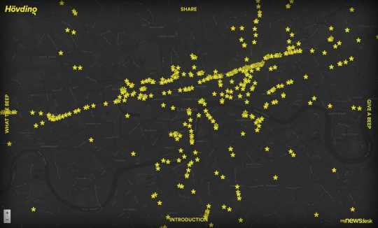
    Here’s what the public map looks like at the time of writing this post:

    Not only does it tell you pain point locations, but it also seems to suggest the primary cycling routes. I think this is a brilliant initiative because, it’s entirely user-centric. It’s telling you how people feel on the ground.

    Supposedly, Hövding is actively looking for other cyclist groups around the world to help them distribute their buttons. So if you’re a group in Toronto or in another city, I would encourage you to reach out to them. The more data the better.

  • Barcelona’s new superblocks

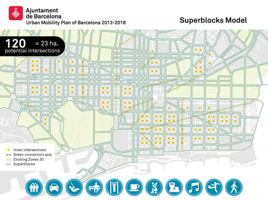
    Barcelona is in the midst of dramatically rethinking its urban fabric to address issues around urban mobility and climate change. Initially laid out in this 2014 Urban Mobility Plan for Barcelona, the city is now implementing something it calls superilles (or superblocks in English).

    Here’s what it looks like:

    The idea is to concentrate transit and vehicular traffic onto the edge of these new superblocks and then convert the interiors into livable spaces for pedestrians and cyclists. Here’s a description from the Agència d’Ecologia Urbana de Barcelona:

    “Superblocks are made up of a grid of basic roads forming a polygon, some 400 by 400 meters, with both interior and exterior components. The interior (intervía) is closed to motorized vehicles and above ground parking, and gives preference to pedestrian traffic in the public space. Though the inner streets are generally reserved for pedestrians, they can be used by residential traffic, services, emergency vehicles, and loading/unloading vehicles under special circumstances. The perimeter, or exterior, of Superblocks is where motorized traffic circulates, and makes up the basic roads.”

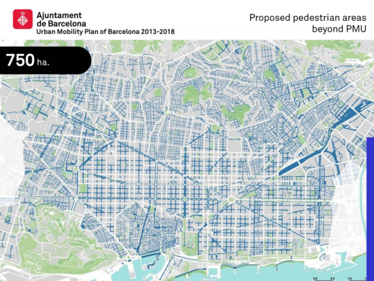
    The result is going to be an absolutely radical shift in the amount of public space given to drivers, pedestrians, and cyclists. When their 2014 report was issued, it was estimated that 73% of public space was allocated to cars (versus pedestrians). This plan will completely flip that ratio. With the superblock model, it is estimated that 77% of public space will now be allocated to pedestrians.

    Here’s what that is expected to look like…

    Before:

    After:

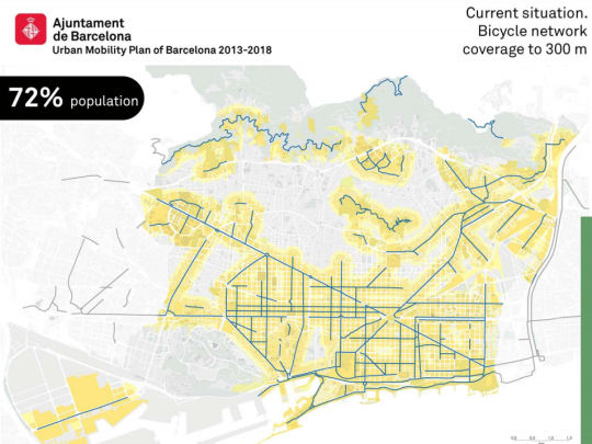
    There are also plans to expand the bicycle network to roughly 95% of the city’s population.

    Before:

    After:

    If any of you are from Barcelona, I would love to hear a local perspective on this mobility plan. Were and are there cries of a war on the car?

    Images: Top image from Tom Walk (Flickr); Maps from Urban Mobility Plan of Barcelona 2013-2018