Daily insights for city builders, delivered every morning at 6 AM ET. I’m Brandon Donnelly — a Toronto-based real estate developer and founder of Globizen. I’ve been writing here since 2013.

Tag: bike lanes

  • Politics and bike lanes

    image

    Recently a good friend of mine told me that I had conflicting views in the world of politics.

    She more or less said to me: I know you’re a real estate developer and obviously a capitalist (read: right of center), but you also support what are often considered to be left of center issues. Issues like tearing down the Gardiner Expressway and building more bike lanes.

    I thought this was an interesting comment because, regardless of whether or not you agree with the categorization she was making, the unfortunate reality is that sometimes (oftentimes?) city building issues do become about left vs. right. Bike vs. cars. Urban vs. suburban. And the list goes on.

    My response to her was that I don’t care about what side of the political spectrum an issue supposedly falls on. That’s a distraction. When I think about something, I try and apply rationale thought and facts to the best that I can. 

    For instance, in the case of bike lanes, I have asked myself: would cities be better off if we had more, or less, people cycling? Simple question. And when I think about this and look at some of the numbers, I see a lot of benefits (this is a non-exhaustive list):

    – More people cycling means we’re moving people more efficiently, which you could argue improves urban productivity and overall quality of life. 

    – More people cycling means we will naturally start prioritizing more compact types of urban form, which in itself has a myriad of socioeconomic benefits. 

    – More people cycling means we’re actually taking action to try and fight climate change.

    – And more people cycling means we’re improving health outcomes. Given that public spending on health care is one of the largest government expenditures in OECD countries, I bet you could find measurable financial savings.

    With all of this, I am not naively suggesting that all cars should disappear from our cities and that everyone should only cycle. I think electric vehicles and self-driving vehicles are going to be an important part of the mobility equation in the future. But I am saying that more, not less, cycling strikes me as an obviously positive thing for our cities. 

    On that note…

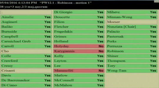
    Toronto City Council voted today in favor (38-3) of a pilot project that will bring separated bike lanes to Bloor Street. The image at the top of this post is how each Councillor voted. So today, we appear to have not fallen into the divide that my friend was talking about. And that makes me, as well as many others, quite happy.

    //platform.twitter.com/widgets.js

    I would be curious how all of you feel about this particular issue. And I would also be curious if you find yourself being more issued based rather than aligned across the political spectrum. That’s certainly how I feel these days.

    I bet we could have a great discussion on this topic in the comment section below 🙂
  • The ROI of cycling infrastructure

    Toronto can’t make up its mind right now as to whether it would like to invest in additional cycling infrastructure. 

    Of course, we have a history of vacillating on topics like this. And I think it’s because we’re at a tricky inflection point. We are weaning ourselves off of the car, but most parts of the city remain underserved by transit and heavily dependent on the car.

    So today I thought I would share some numbers from a research study that was published last year by Stefan Gössling of Lund University and Andy S. Choi of the University of Queensland. It’s called, Transport transitions in Copenhagen: Comparing the cost of cars and bicycles.

    Much of the focus of the paper is on the cost-benefit analysis that the City of Copenhagen uses to make its cycling investment decisions. Here is an excerpt from ScienceDaily:

    “If the costs to society and the costs to private individuals are added together, the impact of the car is EUR 0.50 per kilometre and the impact of the bicycle is EUR 0.08 per kilometre.

    The study by Stefan Gössling and his colleague also shows that if we only look at costs/benefits for society, one kilometre by car costs EUR 0.15, whereas society earns EUR 0.16 on every kilometre cycled.

    “The cost-benefit analysis in Copenhagen shows that investments in cycling infrastructure and bike-friendly policies are economically sustainable and give high returns,” says Stefan Gössling.”

    So there you have it. Now I thought we could debate this in the comment section. Your thoughts?

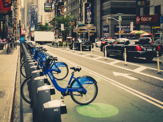
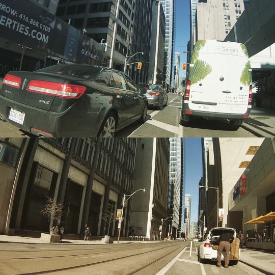
    P.S. The images at the top of this post were taken by me using my new GoPro bicycle handlebar mount.

  • Changing Lanes — A fireside chat with Jennifer Keesmaat and Janette Sadik-Khan

    Citi Bike by Pete  on 500px.com

    https://500px.com/embed.js

    When I was in Miami at the beginning of this month I missed an interesting event that I normally would have attended. It was a conversation between the Chief Planner of Toronto, Jennifer Keesmaat, and the former commissioner of the New York City Department of Transportation, Janette Sadik-Khan.

    Sadik-Khan was appointed under the Bloomberg administration and quite famously oversaw a huge number of urban changes in New York. Projects such as the addition of hundreds of kilometers of new bike lanes and the creation of 60 new pedestrian plazas across the city – including the one in Times Square.

    I was bummed I couldn’t attend, but thankfully Keesmaat wrote a post on her blog following the event and the Metcalf Foundation shared videos of the conversation. 

    Here’s a piece that I liked from Keesmaat’s blog post:

    “But she also pointed out that when they demonstrated what could be done, when they quickly mobilized around action, residents clamoured for similar changes in their neighbourhoods. Not surprisingly, this is why her book is called Streetfight – because it is a fight. City building is often the battle of ideologies, and when you’re trying to change the status quo, there is always a significant demographic of the population that is fully committed to maintaining business-as-usual.”

    If you have some time, you can also click here to watch the videos. There’s about an hour and a half worth of video, so you might want to open up a bottle of wine or something.

  • Before & After: Queens Quay Boulevard

    Yesterday I spent the evening walking Toronto’s new Queens Quay Boulevard, which fully reopened this past Friday after a number of years of construction. 

    It is part of Waterfront Toronto’s revitalization efforts and represents a solid decade in the making. West 8 of Rotterdam and DTAH of Toronto won the international design competition for the central waterfront back in 2006. And this past weekend a big component of that vision was unveiled.

    But first, let’s take a look at what Queens Quay Boulevard used to be like. Here’s a Google Streetview image from 2009:

    image

    The streetcars ran in the middle of the street. Cars drove on the north and south side on both sides of the tracks. And the sidewalks were fairly small and usually at capacity during the busy summer months. It wasn’t a great street.

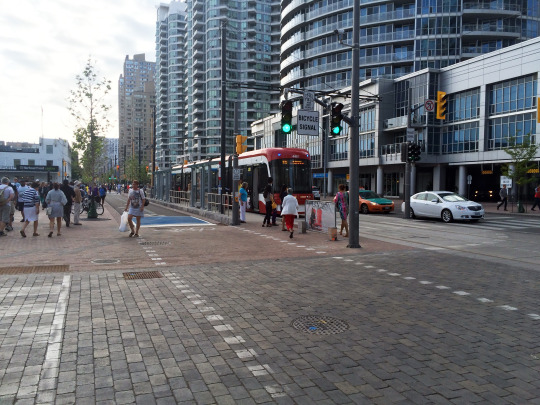
    Now here’s a photo that I took yesterday from that same vantage point (2015):

    image

    The street has been completely reorganized. On the north side of the streetcar tracks is where the cars now drive in both directions. On the south side of the tracks the lanes of traffic have been replaced with a 2-way bike trail (part of the Martin Goodman Trail). And on both sides the pedestrian areas have been greatly expanded. It’s now a magnificent street.

    If you haven’t yet been down to the new Queens Quay, I would encourage you to check it out on either foot or bicycle. (If you go on bicycle, let me know and I’ll join you.) 

    Toronto may have taken a giant step backwards with its recent decision on the Gardiner East, but we also took a giant step forward with the reopening of Queens Quay Boulevard.

  • Seattle’s first protected bike lane makes a quick adjustment

    Seattle recently installed its first protected downtown bike lane on Second Avenue. Here’s a short video of it in action (pay attention to the signalling setup and the pedestrians that walk into the bike lanes). Click here if you can’t see the video below.

    [youtube https://www.youtube.com/watch?v=x2iQCCHlR0s?rel=0]

    Shortly after it opened, they quickly discovered that the left green arrow and solid green circle (shown above) were confusing drivers. The intent was for the left green arrow to signal that you could turn and for the solid circle to signal that you could drive straight ahead.

    But even with the accompanying sign, drivers kept getting confused and thought a green circle meant you could go wherever you want.

    So the Seattle Department of Transportation quickly adjusted and changed the green circle to a north arrow. And it seems to have fixed the problem. I think it goes to show how important the details can be with these things. 

  • What to do when a car is blocking your bike lane

    I was out for a bike ride last night and, on my way home, I decided to try out the new dedicated bike lane on Adelaide Street. Usually I would take King Street, but it was completely full because of Caribana parties.

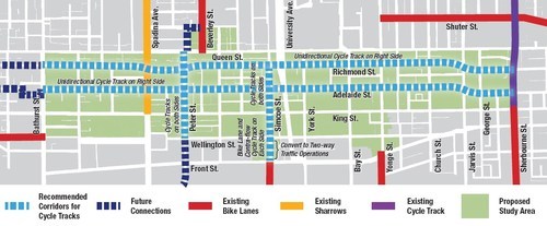
    For those of you who may not be aware, the city of Toronto is currently piloting two dedicated bike lanes on Adelaide Street and Richmond Street in the downtown core. Both streets are one-way and because the lanes were so big to begin with (highway-like spacing), I’m told that these new bike lanes didn’t even eat up a driving lane.

    Here’s a map of the pilot area:

    image

    Given that dedicated bike lanes are a scarce resource here in Toronto, I have to say that it was rather luxurious having my own piece of road. And because there’s no longer any fear of parked car doors swinging open, I was able to ride a lot faster than I normally would. 

    But as my friend Evgeny pointed out earlier this week, there’s a big difference between dedicated and grade separated bike lanes. Indeed, on my trip from Bathurst Street to Church Street last night, I encountered 3 cars parked in my lane.

    //platform.twitter.com/widgets.js

    So, I hope that these bike lanes become a permanent fixture downtown, but that the city makes them grade-separated. I’m sure people will use them. At the same time, I think they could also act as a catalyst for more pedestrian life along both of these streets.

    If you haven’t yet tried them out, I would encourage you to do so. The city is tracking usage and so you would be supporting the cause. And if there’s anybody parked in your lane, below is one way to handle it. It’s a video by Casey Neistat out of New York. If you can’t see it below, click here.

    [youtube https://www.youtube.com/watch?v=bzE-IMaegzQ?rel=0]

  • How mobile apps are going to help us build better cities

    image

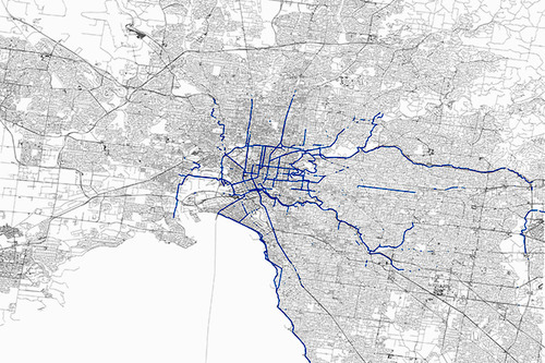
    Some of you might know that I’ve recently started using a mobile app called Strava. It’s a platform that allows you to track your runs and bike rides, as well as those of your friends. It tells you your speed, elevation changes, and it also maps your trips–among many other things. Here’s what my 50 km ‘Ride for Heart’ looks like from last Sunday.

    But what’s even more interesting is how cities are starting to use the data this app collects:

    For $20,000 a year, transportation planners and others can access Strava Metro, which provides an unprecedented look at where and how people are biking. It can tell them where they speed up and slow down, for example, or where they might stay in the street or ride on a crosswalk. That information can reveal where bike lanes or traffic calming measures would be useful, and if those already installed are effective.

    It’s a perfect example of how “tech” is infiltrating so many other sectors. Mobile technology and networks are generating huge amounts of data and it’s happening at an increasing rate. We’re gaining insights into the way people live that simply wasn’t possible before. Some of this information will inevitably be misused, but a lot of it will be used to improve the way we live our lives.

    I know that the City of Toronto also has its own proprietary cycling app and is hoping to collect similar sorts of data from it. But intuitively, I don’t think they’ll be able to compete with the scale of a platform like Strava. Though I certainly applaud the initiative.

    The information age is an exciting time.

    Image: Strava via Wired

  • We want what we want

    This past Sunday night I was out for a bike ride with a few friends all around downtown Toronto. According to Strava, we did almost 22 km. Click here to see our route. During the ride, one of my friends said something to me that stood out. He said that when he’s on a bike he wants all cars off the road; but when he’s in a car, he wants all bikes off the road.

    Now, this may seem like a fairly banal statement, but I think it demonstrates a number of things about people and the way we interact with cities. First, we’re all probably pretty selfish. We want what we want at a specific moment in time and we easily forget what it’s like to be on the other side of a situation.

    Second, I think it reinforces what I wrote a month ago in a post called: Every street can’t be everything to everyone. If we want to improve the user experience for a variety of different use cases (driving, biking, walking and so on), we should decide when and where we’re going to optimize for each. 

    The reason my friend said what he said was because we were riding on a road with no bike lanes. We were swerving in and around cars. And when the street is shared like this it naturally becomes a competition of who can be the most aggressive and dominate the road–bikes or cars. But as exciting as that might be, it’s probably not an ideal way to build our cities.