
Yesterday, Bianca and I biked around 60 km from Cortina d’Ampezzo to Dobbiaco and then back again. It was the most beautiful bike ride that either of us had ever been on. Here's the Strava report.
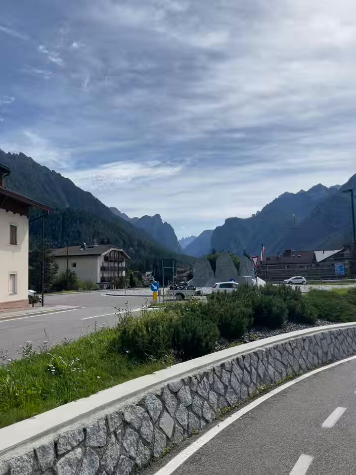
Leaving Cortina, we were on a paved bike trail that had one side dedicated to cyclists and one side dedicated to pedestrians. The views of the valley were breathtaking — both the mountains and the community itself. It felt like we were riding through an idyllic mountain town that couldn't possibly be a real place.

The trail then switched to gravel and that's what we rode on through most of the mountains, including over bridges and through mountain tunnels. I couldn't tell you how many times we had to stop to take photos.

Our first official stop was for a picnic at Lago di Dobbiaco.
Here we were greeted by a bike counter. It was 13:11 and we were cyclist number 243 for the day. The counter for the year was acting up, but I'm guessing it was trying to say between 50-60k cyclists year to date. It was also here that we learned we were on a 560-kilometer trail that runs from Venice to Munich, all the way through the Alps. That would be a fun adventure for another day.

Overall, the cycling infrastructure was incredible. It was one of the things we were most impressed by. When we arrived in the predominantly German-speaking town of Dobbiaco — which is also known as Toblach in German — we were on a dedicated bike path that looked like this:

I couldn't even find any roads leading to some of the homes we were passing. It seemed like residents would have to drive their car onto the bike path just to get home. And once we arrived in the center of town, we were presented with bike lanes, like this, to take us around and underneath busy traffic roundabouts.

This is some of the most impressive biking infrastructure that I have ever experienced, and it's in a small town of 3,300 people. It's also an alpine town that gets bitterly cold winters — significantly colder than even cities like Toronto. So if they can make this happen, why can't we?
Most of the major streets in the older parts of Toronto look something like this:

That is, the right-of-way width is 20 meters. The built form lining the street is retrograde. There are 4 lanes for driving cars (sometimes streetcars run in the two inner-most lanes). And 50% of the entire road is allocated to on-street parking. Now to be fair, on-street parking is usually prohibited during "rush hour." So no stopping and parking during periods like 7-9am and 4-6pm.
But I think this approach to traffic management has become far less relevant today. It made more sense when everyone was driving to an office for 9am and then leaving for the suburbs at 5pm. But today, people want to work from home so they can go to the gym at 11am, go grocery shopping at 1pm, and then get a perm at 3pm.
What I find curious about these decisions is that bike lanes seem to get most of the blame for traffic congestion. We say things like, "nobody really bikes in Toronto except for the 2 weeks of the year when it's nice. So we shouldn't allocate valuable road space to them!" But very rarely do people seem to direct their frustrations toward the parked cars that sit on our roads for, what, ~83% of every day?
One approach allows people to go places and the other is dedicated to storage and immobility. This also says nothing about the relative benefits of people biking: it's objectively a more efficient way to move people, it can improve overall traffic flows by taking people out of cars, and it improves health outcomes (saving taxpayers money).
This is not to say that bike lanes don't also impact vehicle road capacity. But it's a question of what's most optimal for moving the greatest number of people. And I would bet you that on-street parking is far more disruptive to overall traffic flows than bike lanes. Parked cars, it turns out, aren't very good at moving people across a city.

Cycling is good for you. This much is obvious. But what might be some of the lesser known benefits?
Here's a fascinating study (that I discovered through Lloyd Alter's blog), which looked at the association between active travel modes and brain health — specifically dementia risk. For this study, the researchers analyzed nearly 500,000 people in the UK and then tracked them for a median period of 13.1 years. How people got around was classified according to the following groups: non-active (like driving or taking public transit), walking only, mixed-walking, and cycling and mixed-cycling. This latter category is meant to capture people who cycle exclusively and who mix it with other forms of mobility.
Based on this, the researchers uncovered these cycling benefits compared to non-active travel:
19% reduction in all-cause dementia
22% reduction in Alzheimer's disease
40% reduction in young-onset dementia
17% reduction in late-onset dementia
Cycling was by far the best performing category. Why is that? Well, exercise in general is good for brain health. It increases blood flow and oxygenation to the brain, decreases cortisol levels (stress hormone), and reduces anxiety and depression, among many other beneficial things. But perhaps the most important feature for this particular discussion is that it's simultaneously a physical and cognitive activity. In other words, it's exercise, but your brain also has to do a lot of other stuff like balance the bike, avoid obstacles (such as car doors being flung open), and generally navigate an environment with many stimuli.
This gives new meaning to biking for brain health. And it reinforces the case that bike lanes are actually one part mobility infrastructure and one part public health initiative.