Daily insights for city builders, delivered every morning at 6 AM ET. I’m Brandon Donnelly — a Toronto-based real estate developer and founder of Globizen. I’ve been writing here since 2013.
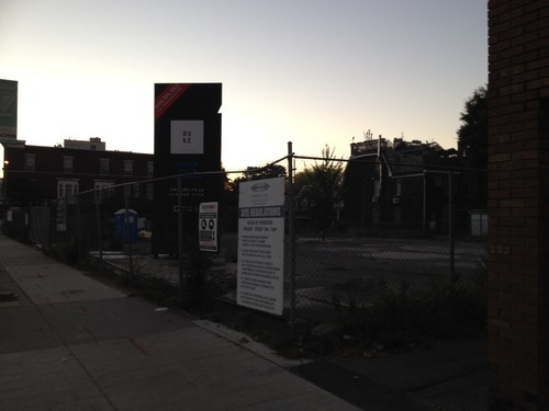
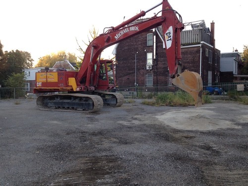
Below was the scene at the DUKE Condos site in The Junction last Saturday morning at 7:00AM. Michael Bros. mobilized their equipment to begin site preparation so that shoring and excavation can begin. The plan is to be at the bottom of the hole by the beginning of next year.
We’re all very excited in the office and so I half jokingly told our VP Construction that I would meet him on-site at 7:15AM with beers. He responded with a one word email saying: champagne. In the end, I decided to go swimming instead (probably a better decision), but I am sure we’ll have a drink soon.
There are still some killer suites available at DUKE, so feel free to drop into the sales office at 2800 Dundas Street West, give the sales team a call at 416-800-7738, or tweet the TAS team with any questions.
Depending on where you live, street numbering may not be something you’ve given a lot of thought to. In Canada, and in many other places in the world, the convention is usually to start on one end of the street and count up – with even numbers on one side and odd numbers on the other.
In many cities in the US, they’re even more rational. The streets themselves are numbered and the addresses indicate location. For example in Philadelphia, where I used to live, if you were going to let’s say 1750 Walnut Street, you would know that it’s between the cross streets of 17th Street and 18th Street. It’s a kind of hyper-rational approach, which lets you know precisely the number of blocks you need to go to get to your destination.
But not all countries and cities are this rational.
According to this Economist article – which a friend of mine forwarded me over the weekend – Costa Rica actually had no street numbering system until about 2012. Which means that directions were all based on landmarks: “100 metres south of the McDonald’s.” It seems almost hard to believe. But I guess that’s why ¼ of all mail was getting lost.
Of course, there are also lots of variations in between these two extremes.
Japan numbers its buildings, but they’re often clustered together in blocks and have no particular order or logic to them. Brasilia (Brazil) also assigns numbers based on sectors, quadrants, and blocks. And in Ireland, where I also used to live, they actually never adopted postal/zip codes. They’re one of the few developed countries in the world not to do that – though it’s coming next year.
If your city or country has a unique numbering system or you’ve come across one in your travels, I would love to hear from you in the comment section below.
There are obviously practical reasons to adopt an easy to understand numbering system. People need to be able to figure out where they’re going. But I would also imagine that there are spatial implications to the way you number and the way you organize your city.
Yesterday morning I went for a swim at the new Regent Park Aquatic Centre. I used to swim regularly when I was in grad school in the US, but it fell off when I moved back to Toronto and there wasn’t a convenient place for me to walk to. Having to drive to a gym or to a pool can really cut hurt how often you’re able to go.
In any case, the pool was fantastic. On the west side of it are glass sliding doors that face the park. And since yesterday was such a beautiful day, they were all open while everyone was swimming lanes. The wooden ceiling also gives the space a nice, warm feel.
The biggest surprise for me though was the universal change rooms. I had never been in a co-ed change room before – or one that was completely open and visible to the pool (there are small private rooms so you can actually change). For families, it makes a lot of sense. Everyone can go in together and it’s easy to watch your kids in the pool from within the change room.
After my swim, I rode my bike around Regent Park and tweeted this out:
What’s happening in Regent Park is incredibly exciting. To me, it feels like a return to the fundamentals of city building. They’ve reconnected the old street grid – which had previously been removed to create the old “towers in a park” scheme – and they’re clearly working towards a proper urban neighborhood with retail at grade and buildings pushed right up against the street.
A big measure of success, though, will be how animated the streets become and how well the retail does. Because all of that isn’t quite there yet. But we’re on our way. And already I feel like we’re about to forget what the old Regent Park used to be like. Toronto may have lived with that neighborhood for over 60 years, but future generations will barely know it existed.
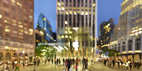
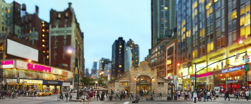
New York photographer Jeff Chien-Hsing Liao has an upcoming solo exhibition at the Museum of the City of New York next month called Assembled Realities. I just heard about it through CityLab.
Pushing the boundaries of traditional documentary photography, Liao (b. 1977) creates large-scale panoramas by combining multiple exposures of the same location taken over the course of several hours. The resulting composite photographs are often fantastical; complex, hyper-real views that no single shot—or the eye—could capture.
I love how his photos begin to distort reality and how they focus your attention – in many cases – on New York’s vibrant street life. I thought you might all enjoy them as well.
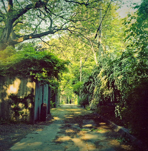
A few months ago I was asked to join the advisory committee of a small Toronto-based non-profit called The Laneway Project. The goal of the organization is to create a network of vibrant, safe, and people-oriented public spaces throughout the city by leveraging our extensive, yet underutilized, network of existing laneways.
It’s still early days, but we are getting ready to actively fund raise. And we’ve also just announced our first event. It’s called Engaging In-Between Spaces, and it’s going to consist of 5 speakers giving super fast presentations on the potential of Toronto’s laneways (think 20 seconds a slide type of thing). There will also be a moderated discussion, and drinks, I’m sure. So mark your calendars for the evening of Thursday, November 20th – more details to follow.
Earlier this week, a friend of mine shared this TED talk on my Facebook wall talking about the state of climate change in the world. The talk is by Nicholas Stern. And at one point he talks about the incredible urban transformation that has taken place in Beijing over the last couple of decades; specifically, the shift from a bicycle oriented city to a now automobile oriented city.
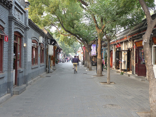
I knew that this was the case, but it got me thinking. Because alongside this mobility change, there’s also been – not surprisingly – pronounced changes to the urban fabric of the city. The most significant is perhaps the demolition of the city’s hutongs and siheyuan. Hutongs are basically narrow alleys (see above photo) and siheyuan are the traditional Chinese courtyard houses.
For centuries, these alleyways and courtyard houses have defined Beijing. And while I realize that not all of them were as glamorous as Melbourne’s laneways, only about 1,000 of Beijing’s original 6,000 hutongs remain (according to Time). Which makes me wonder: Is China making the same mistakes that we made in the 20th century?
Because as the developed world moves toward transit oriented development, bike lanes, heritage preservation, and compact urban living, China has seemingly gone and done the exact opposite. They got everyone off bicycles and into cars, and they went and erased a scale of urbanism that has been in place for centuries.
This is not to say that China doesn’t deserve to have the same standard of living as the developed world. It absolutely does. It just seems a bit ironic to me that the things we’ve become sharply critical of, are exactly what China seems to want to recreate.
This change has been in the works for a number of years. And it’s already allowed in most of Europe and in other places in Canada, such as British Columbia. So it’s nice to see this finally happen here in Toronto.
The reason this is a big deal, and worthy of a blog post, is that it changes the cost structure for mid-rise buildings. Simply put, wood frame buildings are cheaper to construct compared to reinforced concrete and other buildings materials.
Some people think this just means developers will make greater returns. But I don’t think that’s the case (see microeconomics). The real opportunity here is to spur mid-rise development on sites that – before this change – would have been previously un-developable. That is, you just couldn’t make the numbers work.
As much as mid-rise buildings make a lot of sense from an urban design standpoint, it’s not always easy to find good mid-rise development sites. Mid-rise buildings are generally less efficient to build compared to towers and you have a lot of fixed costs that don’t scale down just because you’re doing a smaller project.
So what this change in cost structure will, hopefully, do is allow more product to enter the market. And since many big urban centers operate with perpetual supply deficits – precisely because it’s often so hard to build – this should actually help with affordability.
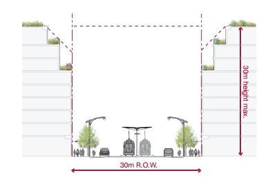
The area that stretches between the property line on one side of a street and the property line on the other side of a street is called a public right-of-way here in Toronto. It may be called something different in other cities and countries.
In the example below (taken from Toronto’s Avenues & Mid-Rise Buildings Study), it includes the sidewalks, the car lanes, and the streetcar lanes. But it could also include other public elements. In this instance, the buildings on either side of the street are assumed to be built right up against their property lines.
ROWs obviously serve an important public function. But their size also has important urban design implications. As a pedestrian, it feels different to walk on a narrow street than it does on a broad street.
The width of a ROW can also be used to inform what the preferred height of the buildings along it should be. In the example above, they’re talking about a 1:1 relationship between the width of the ROW and the preferred height of the buildings.
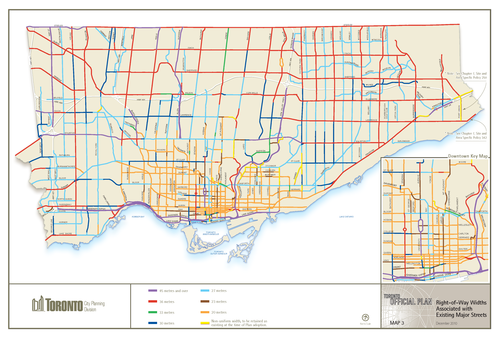
Given their importance, I thought it would be interesting to share this map of Toronto (dated 2010) showing ROW sizing throughout the city. The mustard colored lines in the core of the city represent 20 metres, the red lines 36 metres, and the purple lines 45 metres or more. The rest of the colors fall somewhere in-between. For the most part, the purple lines represent highways, although there are a few other instances of purple.
What’s interesting – but not surprising – to see is how we basically kept expanding the size of our ROWs as Toronto grew outwards. This was obviously to make more room for cars on the road.
But the other, perhaps more interesting thing about this map, is that it could also serve as a guide to pedestrian happiness. The mustard/yellow lines are where it’s most enjoyable to walk. And the red and purple lines are where it’s least enjoyable to walk.
If you’re from Toronto, give this framework a try and see if it holds true.
A few weeks ago I was invited by Toronto realtor Andrew la Fleur to participate in his True Condos podcast series. I had actually never met Andrew before in person, but I knew of him because of Twitter, his blog, and because he was an early user of my past startup, Dirt.
I was initially a bit apprehensive about being on a realtor podcast, because I thought it might end up as some sort of cheesy marketing piece. But I’ve come to learn that Andrew is not that kind of guy. He’s also interviewed some really great people in his podcast series (here’s the full list), so I feel honored to have been invited.
I’ve embedded the podcast below, but if for whatever reason you can’t see it, click here to be redirected to Andrew’s site. We talk for about 30 minutes, with a big focus on openness and transparency in the real estate industry. Thanks again for the invite Andrew. It was great to meet you in person.
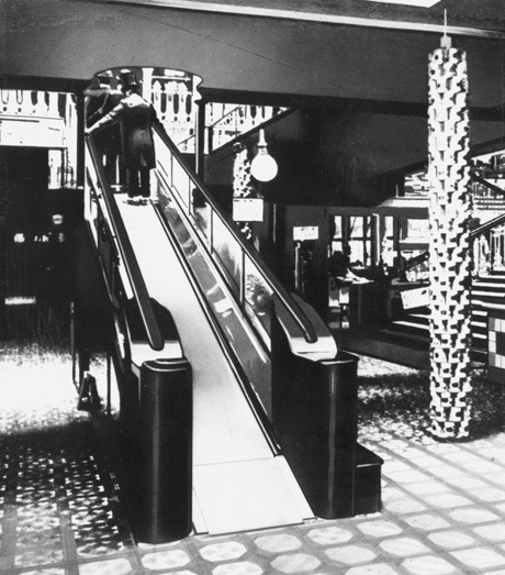
On Wednesday, November 16th, 1898, Harrods department store in London opened up the first escalator – or moving staircase as it was called – in England. The first escalator-like machine in the world had actually been patented many decades before in the US, but this was the first real application in England and likely one of the first in the world.
At the end of the 1800s, this was a big deal. Victorian England had never seen or experienced anything like this before and people were genuinely concerned about its use. More specifically, people worried what such a rapid change in elevation would do to the body. It was believed that it could discombobulate your inner workings. People were unnerved.
Which is why when it was first introduced at Harrods, people were offered brandy and other substances at the top of the escalator in order “to revive them after their ordeal.” Riding an escalator was no small feat for these people.
Now to us today, this sounds ludicrous. Most of us probably ride a few escalators a day. They’re ubiquitous. But I tell this story because I think it clearly underlines how disruptive the new and unknown can feel, and how difficult it can be for us to accept sometimes.
If you go back throughout history, you could easily replace escalators for many other new technologies: the printing press, the automobile, the internet, and so on. And in some cases we were wrong to worry, and in other cases we were right to worry.
Cars, for example, have had a pretty dramatic impact on our lives and the way we build our cities. And since the very beginning, they had no shortage of critics. But does that mean we should have never invented the car? I don’t think so.
As I said earlier this week week, the goal in my mind is to find the right balance between preservation and progress. Just as we shouldn’t be so quick to erase our architectural history, we shouldn’t be so quick to erase our way of life.
But at the same time, it’s important to remain open minded to what’s coming. I’m optimistic about the future. Change can be a great thing, even if it may feel as uncomfortable as riding an escalator for the first time. Maybe you just need a bit of brandy to calm your nerves.