Daily insights for city builders, delivered every morning at 6 AM ET. I’m Brandon Donnelly — a Toronto-based real estate developer and founder of Globizen. I’ve been writing here since 2013.

Tag: zoning

  • How permissive zoning created Toronto’s King-Spadina district

    image

    Over the weekend, Marcus Gee of the Globe and Mail published a terrific article about Toronto’s King-Spadina district and how “condos conquered a rundown district of the city.” (This post will argue that condos were not the catalyst, but an outcome of other changes.)

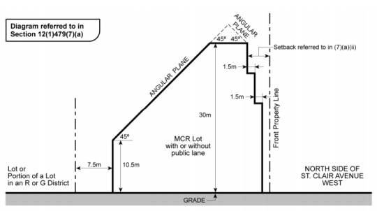
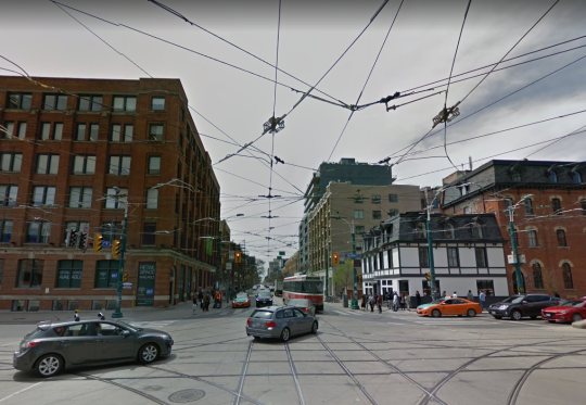
    The image at the top of this post (City of Toronto Archives) is the intersection of King Street and Spadina Avenue around the early 1900s. And here is roughly that same view from May 2016 (Google Streetview):
    image

    From this perspective, it may look like not much has changed. The buildings at the two corners are still there, although their uses have changed. The streetcars are still running, although we now have slightly newer machines. And there are overhead lines providing a canopy across the intersection.

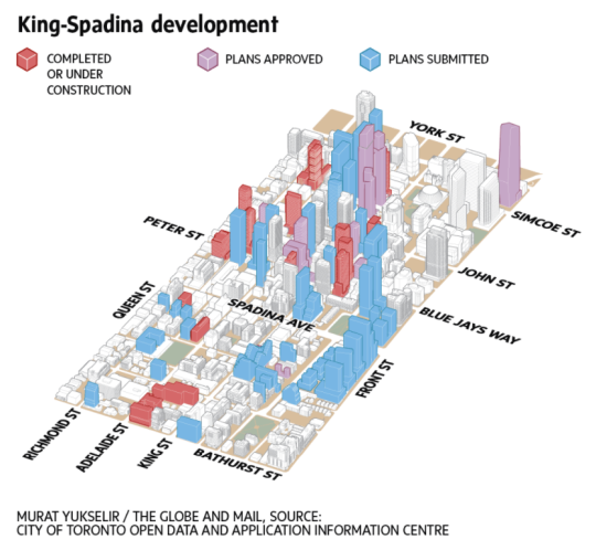
    But as Gee points out, the reality is that in recent years King-Spadina has arguably seen more change and development than any other precinct in the city:

    No fewer than 99 projects have been built, approved or pitched since 2004. That’s one quarter of the total for the entire city and more than the count for two vast suburban districts – Scarborough and Etobicoke – combined. King-Spadina is overtaking even high-rise hubs such as Yonge and Eglinton in midtown Toronto and the Bay and Yonge corridors downtown.

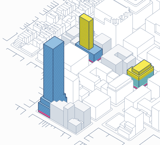
    Below is a diagram showing the built form of that change.
    image

    But as we talk about this massive change, I would argue that this didn’t happen by accident. 

    Gee starts his piece by saying that “cities have an endless ability to evolve, to rebound, to reinvent and regenerate themselves, sometimes in ways that would astonish generations past.” I would add one word: Successful cities have an endless ability to evolve.

    King-Spadina has indeed reinvented itself many times. Prior to its current iteration, it served as a manufacturing district and as the center of Toronto’s garment industry. But from the 1970s through to the early 1990s, the area fell into decline as its manufacturing base left.

    The game changing moment happened in 1996 when “The Kings” – which includes the areas around both King-Spadina and King-Parliament – were redesignated as “Regeneration Areas.” The overarching goal was to deregulate away from single-use industrial zoning and allow the area’s buildings, both old and new, to take on almost any use.

    Now all of a sudden it was possible to have light industrial, commercial, entertainment, retail, residential, and live/work uses all mixed together. And with the bones already in place, the market responded. 

    In my view, it is these earlier changes that laid the groundwork for what has become one of the most exciting neighborhoods in the country.

    However, today some are worried about whether or not this is too much of a good thing. And I am sure that many would like to blame developers for piling up in this neighborhood. Why continue to build here when there’s lots of land elsewhere?

    King-Spadina is a perfect example of what Richard Florida would call “winner-take-all urbanism.” There are powerful clustering forces at play both globally and locally in our cities. And so there are real economic reasons for why King-Spadina has seen more development than Etobicoke and Scarborough combined.

    Permissive land use policies and the right building stock may have kickstarted things, but now economies of agglomeration have taken over. Retailers, restaurants, clubs, tech companies and people, among many others, are now fighting for space in this area for the same reason that Toronto’s garment industry once felt the need to cluster here. There are tangible benefits to doing so.

    What people are effectively asking today is at what point do we start to see diseconomies of agglomeration. This is an important question and one that needs to be actively managed. 

    Without getting into any of the details, I believe that the King Street Pilot Study – which puts transit first along the King corridor – is one very appropriate answer to this question. It is a direct response to diseconomies of agglomeration, in this case traffic congestion.

    But there are important corollaries to this question that are also worth considering: How do we now create more King-Spadinas and how do we create more broad-based and inclusive urbanism in the face of these powerful clustering forces? These are questions that go well beyond King-Spadina, but there are lessons to be learned from the successes seen on the west side of downtown Toronto.

    Images via The Globe and Mail and Google Street View
  • Laneway house zoning variances

    We received the list of required zoning variances for Mackay Laneway House last week and they have been posted to the Globizen blog

    As is said in the post, we have requested clarification on a few items and we will be resubmitting the drawings to address some of the notices. 

    But I still think it’s great to get this information out in the public. It’s the sort of thing that usually doesn’t get published and I know there’s a lot of interest in laneway housing in the city right now. If you haven’t already, please consider signing your name at lanewaylove.com.

    It is, however, a fairly esoteric post. So if this is not your bag, ignore this post and check back tomorrow. Regular scheduled programming will resume then.

  • How Vancouver assesses laneway house eligibility

    image

    Vancouver has supported laneway houses since 2009. So today I thought I would take a look at what their policy considers to be an “eligible lot.” All of the information for this post was taken from this laneway housing how-to guide dated November 2016.

    Here are some of the main ways in which they assess eligibility:

    • Laneway houses are allowed on all lots in the following zones: RS single family zones, RT-11/11N, RM-
      7/7N, RM-8/8N, RM-9/9N and RM-9A/9AN.
    • LWHs are permitted in addition to a secondary suite within the main house.
    • LWHs can be for family use or for rental.
    • LWHs are permitted on lots with a minimum width of 9.8m (32.15′). But provided they are designed appropriately, planning may also allow LWHs on lots as narrow as 7.3m (23′).
    • The LWH site must have access to an open lane.
    • A fire access path must be provided from the street along one of the sideyards to the entrance of the LWH. This path needs to have a clear width of 900mm.
    • The lot must be deep enough to allow for a both a LWH and a backyard open space.
    • The LWH and the main house must have a minimum separation distance of 4.9m (16′).

    If you’re a regular reader of this blog and wondering how Mackay Laneway House stacks up against the above criteria, here are the test results:

    • The lot is in a Residential R Zone, which permits a variety of different building types ranging from detached houses to fourplexes and apartment buildings.
    • The lot width is 7.62m, which exceeds the lower minimum dimension.
    • There is a lane.
    • The access path on the sideyard is 2.38m, but with a bay window projecting into it. So net, it’s closer to 2m, which still greatly exceeds the minimum clear width above.
    • The design includes for a generous backyard between the main house and the proposed LWH. 
    • The separation distance between the first floor of the main house and the proposed LWH is 7.5m (24′-7″). The main house steps back on the second floor, and so this distance would then increase. But in all cases, the minimum dimension is easily exceeded.

    If you’d like to learn more about laneway housing in Vancouver, click here.

  • Envelope Beta

    My friend Bruce of getrefm.com (real estate financial modeling) just introduced me to a new real estate startup called Envelope. Basically it’s 3D mapping software that allows you to quickly visualize the zoning envelope for a particular site. It’s similar to what Flux.io was initially trying to do.

    Now, I think this is very cool, but my first reaction was: What if the zoning is out of date? What if approvals/entitlements are done a site-specific basis? This isn’t the case in every city, but I’ve heard some people in Toronto argue that this city basically has no zoning code. (We can debate that one in the comments, I’m sure.)

    That being said, there are still many design guidelines in this city that shape built form and I could see a tool like this being incredibly useful. They’re still in private beta but I would like to try it out. Hopefully they’ll see this blog post and let me have an early peek.

    Image: envelope.city

  • We’re eliminating parking minimums

    I’ve been writing about the hypocrisy of parking minimums for years now. Some posts here, here, and here

    To me, it doesn’t make sense to try and promote more sustainable forms of urban mobility while at the same time mandating a minimum number of parking stalls in every new development. 

    Do you want people driving or not driving? Pick one.

    That’s why I was happy to see the following action item in the province of Ontario’s five year plan to transition to a low-carbon economy and fight climate change (thank you Ken Wilcox for bringing it to my attention):

    image

    I haven’t gone through the entire action plan and so this post is not a commentary on that. It is, however, a commentary on subsection 1.4. I believe it is the right thing to do and I’m stoked to see it in the plan.

  • Building new, better cities

    Earlier today my friend Saadat sent me the following tweet:

    //platform.twitter.com/widgets.js

    It’s a link to a new research project by Y Combinator – the famed Silicon Valley seed accelerator. They want to explore the possibility of building new and better cities.

    I don’t have the time for something like this, but if any of you are city experts (I know a lot of you are) and you’re based in or willing to be based in San Francisco (I think they are flexible on this), you should absolutely consider applying to be their full time “Cities Researcher.” The deadline is July 30, 2016.

    Here’s a taste of what they are thinking about…

    There are many high-level questions we want to think through, for example:

    – What should a city optimize for?

    – How should we measure the effectiveness of a city (what are its KPIs)?

    – What values should (or should not) be embedded in a city’s culture?

    – How can cities help more of their residents be happy and reach their potential?

    – How can we encourage a diverse range of people to live and work in the city?

    – How should citizens guide and participate in government?

    – How can we make sure a city is constantly evolving and always open to change?


    And there are tactical questions we want to dig into, for example:

    – How can we make and keep housing affordable? This is critical to us; the cost of housing affects everything else in a city.

    – How can we lay out the public and private spaces (and roads) to make a great place to live?

    – Can we figure out better zoning laws?

    – What is the right role for vehicles in a city?

    – Should we have human-driven cars at all?

    – How can we have affordable high-speed transit to and from other cities?

    – How can we make rules and regulations that are comprehensive while also being easily understandable?

    – Can we fit all rules for the city in 100 pages of text?

    – What effects will the new city have on the surrounding community?

    The convergence of city building and tech is something that I’m deeply interested in. I also think it’s inevitable. And I think that Toronto – thanks to our robust real estate industry – is in an ideal position to be a leader in this space. So I would love to see someone from here take on this job.

    But even if you’re not from Toronto, you should still apply because it’s an exciting initiative 🙂

  • Fluted glass curtain wall

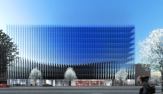
    New York architecture firm REX is working on a new office building in Washington DC that will incorporate a beautiful fluted glass facade. Here’s a rendering of what it is intended to look like:

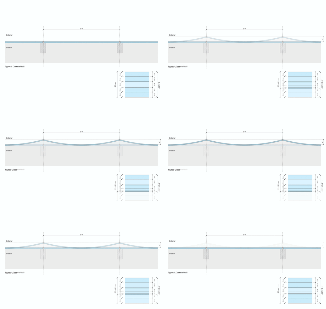
    Here’s what that looks like in plan (it’s a GIF that should show typical curtain wall vs. proposed fluted glass):

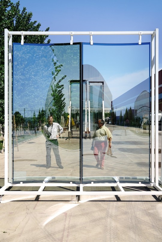
    Here’s a photo of the 1:1 mockup:

    And here’s a description from the architect:

    The façade’s approximately nine hundred identical, insulated-glass panels—3.2 m tall by 1.5 m wide (11’-6” tall by 5’-0” wide)—are subtly curved to a 2.9 m (9’-6”) radius through a heat roller tempering process. The curve yields structural efficiency, which meets wind load requirements and enables a thinner monolithic outer lite than normal, providing greater transparency. 

    Because of the curve’s inherent rigidity in compression, only the top and bottom edges of the panels are supported from the floor slabs, while the mullionless vertical edges are flush-glazed for a minimalist aesthetic that improves sight lines, while gaining usable floor area.

    They are working in collaboration with Front Inc., which if you haven’t heard of, you should check out. They are a design/engineering consultancy that specializes in facades and building envelopes. They work with many of the big name starchitects. The developer of the project is Tishman Speyer.

    It’s worth noting that part of the impetus for the fluted glass facade was to try and innovate within the confines of DC’s draconian zoning – which mandates that no building can be taller than 130 feet. Because of this, developers and architects are usually forced to build out to the allowable area, leaving little room for architectural variation. 

    But in this case, the fluted glass removed the need for thick mullions and also allowed them to extend out beyond the lot area by 4 inches every 5 feet (the curves are considered “architectural features”). So this move has created both architectural variation and more rentable area.

    It doesn’t appear that the building will have any operable windows, but other than that, I think it promises to be quite beautiful. What do you think?

    All images from REX.

  • Enhancement Zones: The mid-rise performance standard that didn’t make the cut

    I’ve written a lot about mid-rise development on this blog and elsewhere. 

    I recently wrote this post responding to a tweet by the Chief Planner of Toronto. And towards the end of last year, I wrote a longer piece for developer Urban Capital’s annual magazine. If you missed it, you should definitely download a copy. Not so much for my article, but because, overall, the UC magazines are excellent. (Credit to David Wex.)

    Today, I’d like to focus on one specific “performance standard” from Toronto’s mid-rise guidelines that I’ve been thinking about lately. But more specifically, I’d like to focus on a performance standard that was initially contemplated but never actually got adopted. 

    (I apologize in advance if this post gets a bit too geeky for some of you. It refers to a specific land use policy in Toronto, but it has much broader relevance.)

    If you take a look at the final Avenue & Mid-Rise Buildings Study and turn to page 56, you’ll see that Performance Standard #5B (Rear Transition to Neighbourhoods: Shallow Properties) was stricken from the report. It was never adopted as a standard.

    So what is this all about?

    This performance standard had to do with something called “Enhancement Zones”, which was proposed as a way to deal with shallow parcels of land on Toronto’s main avenues. You see, because of the other performance standards – namely the angular plane (see images below) – the depth of an avenue site is hugely important for determining what can ultimately be built on it.

    From the city’s perspective, this is a double edged sword. In the case of exceptionally deep lots, you can actually meet all of the performance standards while at the same time exceeding the recommended densities. But in the case of shallow lots, the performance standards sometimes/often make it so that you can’t even achieve the recommended densities. In fact, a lot of sites simply become un-developable.

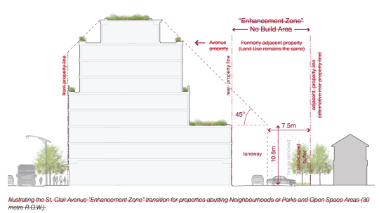
    To give you a visual for what I’m talking about, here’s a section drawing from a zoning by-law that was adopted by City Council for St. Clair Avenue West in midtown:

    image

    Here you can quickly see that if you were dealing with a shallow lot of, say, 25m in depth, you wouldn’t have much left over after taking into account the rear property line setback (7.5m above), the front property line setback, and the 45 degree angular plane. Now you’re beginning to see why I said that it is easier said than done to play creatively within the guidelines envelope (thick black line above). When you look at the feasibility of these projects, you quickly end up getting pushed right up against the glass.

    But this is where Enhancement Zones comes in. 

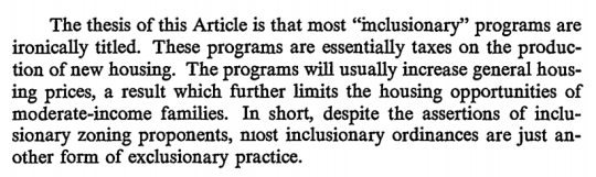
    The idea here is that an adjacent low-rise residential property (or pair of properties in the case of attached houses) could be included in mid-rise development proposals to create a deeper site that then meets the requisite separation distances between the mid-rise scale and the low-rise scale. To be clear, nothing would be built in the Enhancement Zones. They would just help to relieve some of the setback pressures from the original shallow lot and maybe even create a rear laneway system where one did not exist before.

    Below is a drawing from the Mid-Rise Buildings Study showing that new condition. The same 7.5m setback applies at the rear, but now it sits within an Enhancement Zone – formerly an adjacent and separate property. All the text is crossed out because, again, this standard was not adopted.

    image

    From a mid-rise development and feasibility standpoint, this makes a lot of sense. Sites that may have been un-developable before, now become developable. This makes it easier for us to achieve the European-scaled mid-rise vision that Toronto has for its avenues.

    But for reasons that I am sure you can guess, there are concerns with this performance standard. Probably the most obvious is that, to a certain extent, it destabilizes “neighbourhoods.” And they are intended to be completely stable entities that see little to no intensification. As soon as you allow this to happen, properties sitting in Enhancement Zones would become the prey of developers.

    However, there are counter arguments you could make. The owners of these properties would likely receive offers above market value. So maybe they end up better off. At the same time, you could also argue that the more development we unlock outside of “neighbourhoods”, the more stable they can actually remain.

    In any event, I’ve been thinking about this lately and I thought it would be interesting to debate the pros and cons of these magical-sounding Enhancement Zones. For those of you inclined to engage in geeky planning discussions, I’d love to hear from you in the comments.

  • Thoughts on inclusionary zoning

    Ontario is looking to pass legislation that would allow municipalities in the province to implement something known as inclusionary zoning. If passed and should municipalities decide to use this tool (Toronto almost certainly would), developers would then be required and/or incentivized to include some percentage of affordable housing in their new market rate developments. 

    Politically, inclusionary zoning tends to be popular. It’s believed to be a way for governments to create new affordable housing using relatively small public subsidies. Not surprisingly though, the development industry generally hates IZ. It’s another cost that needs to be added to the development pro forma – though some municipalities rightly offset these additional costs with additional density, breaks on levies, and so on.

    What I always think about when this topic comes up is the broader economic impact of the land use policy. Because I’m suspect that it’s as simple as: mandate affordable housing; get more affordable housing for free. Generally there are always trade-offs.

    So here’s some reading material for you all this morning.

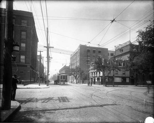
    In a classic paper (1981) by Yale Professor Robert C. Ellickson – called The Irony of Inclusionary Zoning – he argues that these practices can actually increase general house prices:

    image

    As a counterargument Owen Pickford over at The Urbanist argues that IZ simply reduces land prices as a result of the new tax. Land, after all, is the residual claimant. Therefore, he believes it’s an effective affordable housing policy. (I’m not so sure I believe that land prices would decrease in practice.)

    There’s also debate about the effectiveness of inclusionary zoning to actually deliver affordable housing at a meaningful scale. City Observatory wrote a post that looked at the total number of units produced (through IZ) across a number of American cities and the results were spotty. It should, however, be noted that not all inclusionary zoning policies are mandatory.

    Finally, the Furman Center for Real Estate & Urban Policy at New York University published a housing policy brief back in 2008 that looked at this exact topic. While they admit that the data is scarce, they come to the conclusion that IZ had no meaningful impact on the prices and production of single-family housing in San Francisco, but that IZ seems to have slightly decreased production and slightly increased pricing in the suburbs of Boston.

    What this last point suggests is that inclusionary zoning policies are not all created equal. So like all difficult questions, the answer to this one is likely: it depends. If anyone can point me to better data on inclusionary zoning, I would love to see it.

  • Easier said than done

    Earlier this week I saw the Chief Planner of Toronto, Jennifer Keesmaat, tweet this out:

    //platform.twitter.com/widgets.js

    I responded with the below quote retweet because I figured I should probably devote a blog post to this topic and not just a tweet.

    //platform.twitter.com/widgets.js

    Now, I don’t know for sure, but I am guessing that her tweet was in response to the criticism from architects and developers that Toronto’s design guidelines are creating homogenous architectural outcomes. Some people – and I’ve written about this before on ATC – believe they’re too prescriptive.

    So today I’d like to talk about why playing creatively within the guidelines/zoning envelope, particularly at the mid-rise scale, is a lot easier said than done.

    Generally speaking, the value of land is dependent on what you can do with it or, in this case, what you can build on it.

    If all you could do was plant things on it, then the value of the land would be correlated with crop yields. If on the other hand you could build a building, it would be correlated, at least in theory, with the amount of space you could build and the rents you could charge for that space.

    Of course, this isn’t a perfect science. That’s why I said “in theory.”

    Landowners obviously want to maximize the value of their asset when it comes time to sell. So they, along with their brokers, will naturally try and stretch what is possible with the land. Why else do you think the best neighborhoods seem to magically grow new boundaries?

    When you combine this with the fact that mid-rise buildings are inherently less efficient to build and with the fact that their smaller size creates diseconomies of scale, it can be exceptionally difficult to find development sites where the numbers make any sort of financial sense. That is, even if you “maximize the envelope” and push rents or sale prices.

    So, with all due respect, not maximizing the envelope is almost unthinkable, unless you somehow managed to get a bargain on the land.

    Many of you will likely respond in the comments saying that all of this is simply a result of real estate developers being greedy capitalist pigs. But what we are talking about is no different than in any other competitive business environment. 

    Developers rent and sell products – albeit products that take an incredibly long time to make and bring to market. To make those products, there are a many costs, ranging from the cost of land to the cost of drawings. But hopefully within all of those numbers sits a profit margin that makes sense given the amount of work and risk that the developer has taken on. 

    Put differently, telling developers not to maximize the envelope is like telling a pizza maker to throw out 10-15% of her dough before she makes every pizza – even though she already (over)paid in full for the dough.

    If you’ve ever created a development pro forma, you’ll know that it’s not easy getting the numbers to work when you’re operating in a competitive market. This is not a knock against creative design. Trust me, I am a design snob. This is just business.