Daily insights for city builders, delivered every morning at 6 AM ET. I’m Brandon Donnelly — a Toronto-based real estate developer and founder of Globizen. I’ve been writing here since 2013.

Tag: yonge street

  • Show Yonge some love

    image

    Since last summer the Downtown Yonge Business Improvement Area in Toronto has been running a really creative community engagement program at yongelove.ca.

    The site includes a short history of Toronto’s most famous street, an Instagram contest (use #YongeLove to participate), and a survey where both locals and visitors can provide their feedback on what they think the future of Yonge Street should be.

    The reason this is being done is because, in 2016, Yonge Street from Davenport Road all the way south to the lake will be ripped up for infrastructure upgrades. And so it was rightly determined that now is the right time to rethink the future of Yonge. Let’s do this once.

    I’ve already talked about the Yonge-Redux proposal here on Architect This City and that seems to be where everyone’s head is at in terms of what they would like to see. I also think it’s the right thing to do for Yonge Street. If you’ve ever been on Lincoln Road in Miami or La Rambla in Barcelona, you’ll know how magical a great street can be.

    So I’d encourage you to complete the Yonge Love Survey and advocate for something awesome. It ends next month, after which time all the feedback will be forwarded to the city.

    I’d also love to hear what you think and how you responded in the comment section below. My response was more or less geared towards supporting the Yonge-Redux proposal.

  • Q&A on reimagining public spaces

    I received an email from an ATC reader yesterday who is working on a publication about reimagining public spaces in Toronto. She sent me a few questions and specifically wanted to talk about the Yonge Redux project, which I wrote about a month ago. After I responded to her questions, I figured I should just share them publicly. So here they are:

    How would citizens from different age groups benefit from the Yonge Redux project?

    I would bet you that this stretch of Yonge Street experiences more pedestrian traffic than it does car traffic. And yet we’ve allocated space in the opposite direction: cars have more space than pedestrians do. So what this project is really about is reallocating the street, or public right-of-way, so that the dominant uses are actually prioritized through urban design. It doesn’t need to be more complicated than that. Ultimately, this will benefit people both young and old.

    Do you know what kind of professionals are needed to complete a project like this?

    You’d need an architect/designer – one who is awesome at landscape/urban design work. gh3 here in the city comes to mind as a firm I like, if you want an example. You’d need a bunch of engineers to deal with stormwater management and other infrastructure items. You’d likely need a transportation/traffic consultant to assess traffic flows in the area and prove that this project won’t cause the entire city to come to a grinding halt (it won’t). You would need someone to manage the day-to-day of the entire project. And this is just naming a few of the professionals/consultants that you’d probably end up needing.

    You’d also have to work closely with the city, the local councillor, and the local community. It’s inevitable that some of the businesses will worry about the loss of potential customers – so that would need to be worked through.

    What are some areas in Toronto that, in your opinion, need reimagining in the next few years?

    My feeling is that Toronto is still at the early stages of this shift towards better public spaces and a better public realm. But in many ways, projects like Yonge Redux are much easier sells compared to the other areas that could use a face lift. Yonge Street is already urban and pedestrian friendly. The real challenge is going to be dealing with the areas outside of the core – most of which, frankly, aren’t that welcoming to pedestrians and aren’t all that urban. What do we do with those? And do the local communities even want them transformed? They’re going to be much harder to reimagine (though I’m not saying we won’t be able to do it).

    Where do you see the future of Toronto’s public spaces in the next 50 years?

    All signs point to a more dense, more urban, and more transit-oriented city. With that shift, we’re going to increasingly realize the importance of incredible public spaces. So if we continue down this path, I reckon our public spaces will only get better. I’m optimistic about the future.

    How would you personally approach a project like this?

    My understanding is that this project has legs. It just has to work through the city bureaucracy at this point. Jennifer Keesmaat supports it.


  • TIFF: Getting ready for guests on King Street

    image

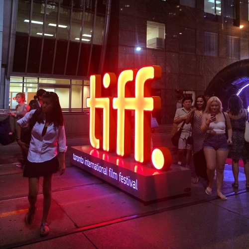
    Right now the Toronto International Film Festival is going on in the city. It’s actually one of my favorite times in Toronto. There’s so much going on and the city generally does things that it doesn’t normally allow, but that it should do all throughout the year, such as extending last call at bars and closing down streets to cars.

    This year, King Street between University Avenue and Peter Street has been made pedestrian-only. It encompasses an area known as the Entertainment District and includes the Bell Lightbox, which is the TIFF HQ. The street was closed last Thursday and will reopen this Monday. So it’s a 4 day thing, that TIFF is calling “Festival Street.”

    Some people – like me – are really excited about this. Here’s s picture I tweeted out on Thursday night. Given the engagement (retweets/favorites), I think there are others who feel the same way I do:

    //platform.twitter.com/widgets.js

    But there are others who are furious that their commute was disrupted last week and that we’re inconveniencing locals for the sake of hosting one of the top film festivals in the world. (King Street typically moves about 60,000 people per day on the streetcar and 20,000 vehicles.)

    But when I walked the entire 650 meter stretch on Thursday night, it was completely full of people. There were people playing large-scale chess. There were people eating at picnic benches. And there were lots of people just enjoying a wonderful summer stroll in the city.

    And all I could think about is that this is an unmet need in the city. King Street is a wonderful place to be right now and we don’t have an equivalent during the other 361 days of the year here in Toronto. So rather than be upset that we’ve closed down 6 blocks of downtown, I’m only upset that we don’t do more of this and make it permanent during the rest of the year. 

    I’m not necessarily saying that King Street is the best place to do this. Yonge Street initially strikes me as being a better place to start. But I am saying that if we have to reconfigure things to make our city more awesome for when guests come over, that maybe we should think about how to make it more awesome all the time.

  • A new vision of Yonge Street

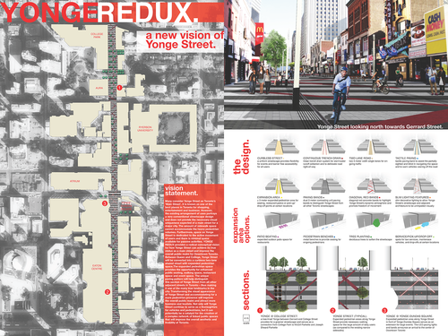
    Back in April I wrote about a competition for young people to reimagine public space in Toronto. It was called NXT City. Well that prize has been awarded and the winner was Richard Valenzona for his vision–called Yonge-Redux–of a new and reimagined Yonge Street. To download the PDF of his entry (the image shown above), click here.

    The proposal encompasses a stretch of Yonge Street that runs from Queen Street in the south, to College Street in the north. It would capture the Toronto Eaton Centre (mall), Yonge-Dundas Square, Ryerson University’s expanded Yonge Street footprint, and the massive mixed-use developments happening in the College Park area (see Aura Tower). To quickly simplify, the proposal is essentially about enhancing the urban experience, prioritizing pedestrians, and reducing the flow of cars to two lanes.

    Overall, I think it’s a wonderful proposal and I’m not surprised it won NXT City. This type of intervention is on so many of our minds. In fact, it’s somewhat surprising that we’ve been as slow as we have to improve our main street. There are so many anchor institutions, such as the Eaton Centre and Ryerson University, that plug into this section of Yonge Street. It makes a lot of sense.

    But as I said in my original post, one of the most exciting things about the NXT City Prize is that it has always been about execution. This is not just an academic exercise–or at least that’s the hope. This exercise is about spurring real change in the city and I genuinely hope that they’re successful in doing so. Because then I can turn around and say: Take that Melbourne 🙂

    Kudos to Richard Valenzona, Mackenzie Keast, as well as everyone else involved in NXT City, for making this initiative a reality and for doing your part to make Toronto even more awesome.

  • Toronto’s concession roads

    I’m late in writing this blog post because I was up in Collingwood for the day snowboarding. I’m exhausted, but I do have something to say.

    One of the things I always find interesting when I’m driving north of the city is how far Toronto’s major north-south streets extend. Go out to Aurora or Newmarket and you’ll still come across many familiar faces such as Jane, Keele, Dufferin, Bathurst and Yonge Street. And the distance between each of them is exactly the same as it is in the city: 2 kilometres.

    This may not seem like much of a big deal, but have you ever wondered how this street grid was established?

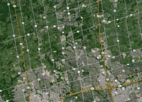
    These streets are actually concession roads. And they were used to subdivide undeveloped land in Upper and Lower Canada into a grid that could then be further subdivided into farming lots. Each square of the grid is 2 km x 2 km, or 1,000 acres.

    Look at a map of the Greater Toronto Area and you’ll see it:

    image

    But what I find most intriguing about this grid system is that it was designed around farming—not our current use case. The intent was to further subdivide each 1,000 acre lot into smaller 100 acre farming lots. And these concession roads were for access—they weren’t city blocks.

    By comparison, there’s another city that’s famously run off a regular street grid. You may have heard of it. It’s called New York. And its street grid was established in the Commissioner’s Plan of 1811. Some even go so far as to say that it’s “the single most important document in New York’s development.” 

    But New York’s grid is much different than the one I’m talking about. Because of its smaller scale (20 blocks a mile going north-south), New York’s was decidedly urban. It was meant for city building.

    Now, in the case of Toronto, concession roads obviously never stopped us from developing a thriving city. We filled in each square to make them as urban as we needed them to be. But as planning ideals changed, so did the infilling of those squares. Our grid was flexible enough to accommodate everything from farm land to suburban subdivisions.

    But I can’t help but wonder how the Greater Toronto Area would have turned out had we, quite simply, chosen a different size of square. What if instead of 2 km x 2 km, we had made them 1 km x 1 km? Or what if we made them even smaller? What would the Toronto region look like today?

    Sometimes it may seem like a simple decision, but in reality the implications are huge.

  • Pier 27 and transparency in the real estate industry

    One of my favorite development projects going up in Toronto right now is the Pier 27 complex at the base of Yonge Street.

    What I love about it is that it’s trying something different. The two sky bridges that sit atop the two phases—currently under construction—are going to create a remarkable new focal point along the waterfront. It’s not just another condo.

    And as I watch the buildings go up, I’ve also been impressed by the materials used on the project. In particular the curtain wall (glazing) system used on the eastern most buildings. It’s a clear glass installation with white accent pieces. It’s beautiful. Here are a few photos.

    But as much as I love this project, it’s been slow moving. This project, like many others in the city, has been subject to a number of delays. They went to market in 2006-2007 and occupancy isn’t expected until next year—a good 7 years later.

    But more than the issue of time, my real concern is the lack of transparency. Why was it delayed? Were sales slow? Were there dewatering issues being on reclaimed land along the waterfront? Was the soil contaminated? As a consumer, it’s frustrating being in the dark.

    I do, however, acknowledge that this is a larger issue facing the real estate industry. We’re certainly not known for radical transparency. We’re a closed and insular industry. But over time I do believe that will change. It’s inevitable. And the best thing you can do today—as an organization or as an individual—is to embrace it.

    Full disclosure: I have a vested interest in this project and I’m currently having a fight with the developer over a small amendment I would like to make to the agreement of purchase and sale. They have been unwilling to cooperate.