
Daily insights for city builders, delivered every morning at 6 AM ET. I’m Brandon Donnelly — a Toronto-based real estate developer and founder of Globizen. I’ve been writing here since 2013.

Tag: walking

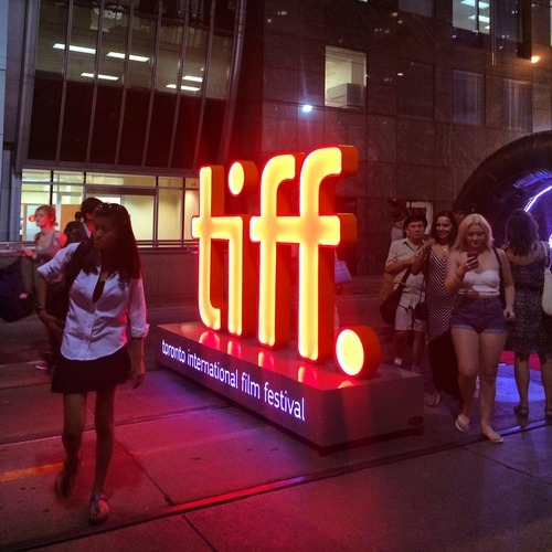
  • TIFF: Getting ready for guests on King Street

    image

    Right now the Toronto International Film Festival is going on in the city. It’s actually one of my favorite times in Toronto. There’s so much going on and the city generally does things that it doesn’t normally allow, but that it should do all throughout the year, such as extending last call at bars and closing down streets to cars.

    This year, King Street between University Avenue and Peter Street has been made pedestrian-only. It encompasses an area known as the Entertainment District and includes the Bell Lightbox, which is the TIFF HQ. The street was closed last Thursday and will reopen this Monday. So it’s a 4 day thing, that TIFF is calling “Festival Street.”

    Some people – like me – are really excited about this. Here’s s picture I tweeted out on Thursday night. Given the engagement (retweets/favorites), I think there are others who feel the same way I do:

    //platform.twitter.com/widgets.js

    But there are others who are furious that their commute was disrupted last week and that we’re inconveniencing locals for the sake of hosting one of the top film festivals in the world. (King Street typically moves about 60,000 people per day on the streetcar and 20,000 vehicles.)

    But when I walked the entire 650 meter stretch on Thursday night, it was completely full of people. There were people playing large-scale chess. There were people eating at picnic benches. And there were lots of people just enjoying a wonderful summer stroll in the city.

    And all I could think about is that this is an unmet need in the city. King Street is a wonderful place to be right now and we don’t have an equivalent during the other 361 days of the year here in Toronto. So rather than be upset that we’ve closed down 6 blocks of downtown, I’m only upset that we don’t do more of this and make it permanent during the rest of the year. 

    I’m not necessarily saying that King Street is the best place to do this. Yonge Street initially strikes me as being a better place to start. But I am saying that if we have to reconfigure things to make our city more awesome for when guests come over, that maybe we should think about how to make it more awesome all the time.
  • The war on the car

    image

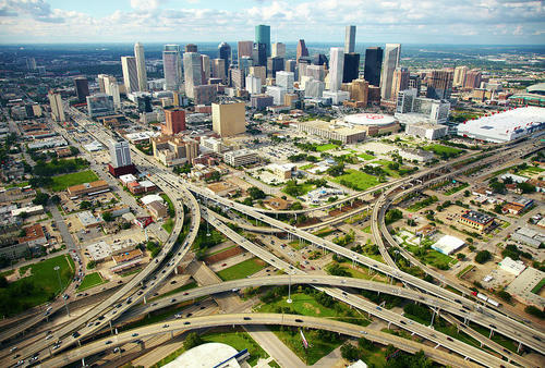
    In today’s post I’d like to focus on the second tweet I embedded in yesterday’s piece about downtown Toronto. Specifically, the fact that almost 75% of downtown residents walk, cycle, or take transit to work, leaving drivers firmly in the minority.

    For me, this then makes me question whether or not we’re optimizing well enough for the majority. However, it’s often not that simple. And that’s because the downtown core is clearly regional in its draw, and the further you move out from the downtown core, the more the modal split flips. In the suburbs, driving is obviously the majority.

    And herein lies the tension and the reason for all this “war on the car” rhetoric: We have a downtown core with completely different mobility preferences than the rest of the region.

    But as Toronto continues to intensify and grow (the population of the Greater Toronto Area is projected to reach almost 9 million by 2036), I truthfully don’t know how we could reasonably expect to (efficiently) move that number of people in private cars. I’ve just never seen it done before.

    Some people think that if we simply got rid of all those damn streetcars on our city streets, that we’d be doing a lot to eliminate traffic congestion. But it’s not that simple. The Highway 401 here in the city is already 18-lanes and one of the widest in the world. And yet it’s perpetually clogged. No streetcars there.

    So I look at this tension as a growing pain. Sooner or later I think we’re going to realize that this war should really be a war on inefficiency. How do we move lots of people around big cities while minimizing waste, maximizing economic output, and enhancing quality of life?

    Now that’s a war worth fighting.

    Image: Helibacon

  • Mapping public transit travel times

    image

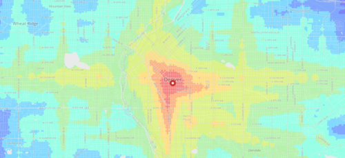
    I just came across an interesting web app created by geographer and programmer Andrew Hardin that maps public transit travel times for San Francisco, Seattle, Boulder and Denver.

    The app allows you to click on a location within one of these cities (or enter an address) and then receive a visual representation of travel times from that location.

    Both public transit and walking are factored in, and the fastest of the two is then modeled. The public transit data is taken from each respective authority and is similar to the data used by Google Maps.

    With these sorts of applications, I always wonder what it might look like overlaid with additional data points, such as home prices. Intuitively I would expect the best connected neighborhoods to also have some of the highest real estate values.

  • Measuring urban form

    Last night the Toronto Transit Commission offered free service starting at 7pm. This is typical of Toronto on New Year’s Eve, as it is with many other cities. I think it’s great thing to do and I love seeing so many people taking transit to get around. I took it everywhere last night.

    Since I knew I would be doing a lot of walking, I charged up my Fitbit Flex and strapped it on around lunch time. Here is my New Year’s Eve according to Fitbit. I took 11,239 steps yesterday afternoon/evening.

    Activity tracking and health monitoring devices have really taken off over the past year. And I absolutely do think they help motivate. But beyond an individual level, I also think this data could be really interesting in aggregate and overlaid with other data points, such as where people live, where they work, how they travel/commute, and so on.

    Many have speculated that urban sprawl makes people fat since it privileges driving over walking. But with all the data that companies such as Fitbit and Nike are collecting, it would be interesting to see some hard data on how much more urbanites really walk compared to suburbanites.

    One idea would be to use Walk Score and examine the correlation between the walkability of a person’s neighbourhood and the average number of steps they take everyday. Intuitively, it seems like there would be a strong one. But it would be cool to see it quantified. I’d happily share my data if somebody would like to take this on.

    Happy New Year, everyone. Welcome to 2014.

  • How I walked today

    A couple of months ago I picked up a FitBit Flex. For those of you unfamiliar with the wrist device, it’s similar to the Nike FuelBand.

    I bought one for really two reasons.

    The first is that I think it’s pretty clear at this point – with Google Glass and rumours of an Apple iWatch – that wearable computing will eventually be a massive market opportunity. Who knows, it could do to mobile what mobile did to PCs.

    The second reason is that I love data. I love measuring and tracking things. And it’s probably the main reason I use apps like Foursquare fairly regularly.

    To this end, here’s how I walked today:

    It’s pretty typical for a day of commuting: To the office in the morning; out and about at lunch; and then back at the end of the day.

    In terms of the value I get out of this, it’s more for novelty than anything else at this point. The FitBit app has a lot of features to track caloric intake and other things, but I only use it to track things it can do passively.

    That said, I like being able to quickly see how close I am to my daily step goal of 15,000. On most days I don’t hit it.