Daily insights for city builders, delivered every morning at 6 AM ET. I’m Brandon Donnelly — a Toronto-based real estate developer and founder of Globizen. I’ve been writing here since 2013.
As far as videos and photos go, it’s probably as close as you’re going to get to actually being there. And if you’ve never been to Rio de Janeiro (which I haven’t), it’s a great way to see and understand the city’s built environment. I loved looking at all of the details.
Google wants to build a new campus in Mountain View, California. Their objective is to create a space where “people, nature and ideas” can thrive. The architects on the project are Bjarke Ingels and Thomas Heatherwick.
Last week Google released a video talking about the ambitious project. It is a good watch and only 10 minutes. Click here if you can’t see the video below.
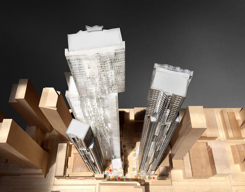
The developers behind the much talked about Mirvish+Gehry project in Toronto (Projectcore) recently released a video showcasing the architectural model. It’s a great way to see the project from every angle. Click here if you can’t see it below.
I’ve written about this project a number of times before and my view has always been that I’m excited by the project, but that I don’t think we should be demolishing all of the heritage buildings on-site. This latest scheme – with two towers ranging from 82 and 92 storeys – is the result of that compromise.
What are your thoughts on Mirvish+Gehry? And what do you think the condos will ultimately go to market at? My guess would be somewhere around $1,000 per square foot.
This past week was Toronto’s first real snowstorm of the season. It was awesome. I love snow. And part of the reason I love it, is because it means snowboarding season is here. Yes, the “mountains” in Ontario suck, but Quebec and Vermont aren’t too far away and every February there is The Annual.
This year in preparation for the season I decided to splurge on a GoPro camera. We had a lot of fun filming last year in Jackson Hole and, since it looks like we’re going to have close to 10 people at this season’s Annual, I wanted to throw another camera into the mix. Expect another ski and snowboard video sometime in February 2015. We’re heading out to Alberta and British Columbia.
I also ordered this mount for the camera:
But as I was ordering the camera, I started to think about what else I could use it for. And then it hit me: city tours. One of the things I love to do in the summer is ride my bike around the city and explore. I like to find areas I don’t know very well, find new developments I may have missed, and generally just get to know the city more intimately.
Being on a bike is really the perfect way to do this. You don’t cover enough ground walking and with driving you simply miss too much of the city. So what I want to do is strap my GoPro to my handle bars and bring you along for these exploratory bike tours. I think it could be a unique way to show you the city – even if you happen to also be from here.
How does that sound?
It likely won’t happen until the spring, but if you’re interested in joining me, let me know. I think this could be a lot of fun with a group of city geeks.
Two weeks ago I gave a brief presentation at The Laneway Project’s inaugural summit here in Toronto. I then wrote about it here on ATC.
At the time, I wasn’t sure if the event was being filmed or not, but it turns out it was. So here is my presentation from the event. It’s just over 7 minutes. Click here if you can’t see it below.
If you’d like to see the other 5 presentations and the Q&A session, click here.
Following the event, I was also interviewed by a radio show out of Calgary called Space + Place. If you are really into laneways and would like to listen to that as well, go here.
I’ve said this before, but I’ll say it again: I continue to be amazed by how much interest there is — both here in Toronto and elsewhere — in laneways. They may be overlooked today, but that’s going to change. It’s inevitable.
Yesterday UrbanToronto.ca published a post talking about Melbourne’s laneways (something I also wrote about here on ATC a few months ago). As part of their post, they included the video that I’ve embedded below. I think it does a good job of showing the vibe and energy in these repurposed laneways, and so I wanted to share it with you all as well. What are your thoughts on these spaces? I think they’re great.
This morning I finished watching the rest of Steve Jurvetson’s Spark 2014 talk, which I shared with you all yesterday. And so I’ve got technology on the brain right now.
I’ve said this many times before on ATC, but I truly believe that the pace in which technology is infiltrating “non-technology” companies is only going to increase. The video clip of Flux.io is a perfect example of that. After watching that demo yesterday, I immediately thought a handful of consultants that real estate developers use on projects that the Flux platform could replace.
So today I thought I would share another company that Steve talks about in yesterday’s video called Planet Labs. Planet Labs’ mission to image the entire world and make it universally accessible to people. But unlike Google and Microsoft – who already offer satellite photography – Planet Labs has figured out a cost effective way to do it on a daily basis.
Because the problem with services like Google Maps and Bing is that they’re updated too infrequently. If I go to Google Maps right now, the building I live in doesn’t even exist in their aerial photography of Toronto – it’s still a parking lot. So there are limits to what you can do with this information.
But once you increase the image frequency to daily, you create all sorts of new opportunities. You could track the number of cars in every parking lot in the world to measure retail activity (an example Steve gives in his talk). You could track changing water levels. You could track deforestation. You could track urbanization in China. And the list goes on. Here’s a blog post from Planet Labs that gives a few examples of the benefits of daily imaging.
To return to my earlier point, consider the fact that every potential use case I’ve just outlined is in an industry that most of you wouldn’t consider to be tech. And yet Planet Labs is clearly a technology company. So the key insight here is really to focus less on the way things are done and classified today, and more on the way they could be – and likely will be – done in the future.
If you’re involved in the built environment in any way, shape, or form – as a developer, architect, policy maker, and so on – I would highly recommend you watch the video below. My friend Candice Luck, who I went to Rotman with, sent it to me this morning with a link starting at the 24 minute mark. I haven’t yet watched the whole thing, but given how interesting this short section was, I plan to.
The video is a talk by Steve Jurvetson, who is a venture capitalist with DFJ. He was one of the founding investors in Hotmail and currently sits on the board of companies like SpaceX and Tesla Motors. At the 24 minute mark he talks about a startup called Flux.io that hasn’t yet launched their product, but is working towards “reimagining building design”. They’re a spin-off from Google X and plan to officially launch in early 2015.
Rather than try and describe the video here, I will just say that it’s an incredible example of how technology and digitization could completely change the real estate development industry. If you can’t see the video below, click here. The video starts at the Flux.io section.
Seattle recently installed its first protected downtown bike lane on Second Avenue. Here’s a short video of it in action (pay attention to the signalling setup and the pedestrians that walk into the bike lanes). Click here if you can’t see the video below.
Shortly after it opened, they quickly discovered that the left green arrow and solid green circle (shown above) were confusing drivers. The intent was for the left green arrow to signal that you could turn and for the solid circle to signal that you could drive straight ahead.
But even with the accompanying sign, drivers kept getting confused and thought a green circle meant you could go wherever you want.
So the Seattle Department of Transportation quickly adjusted and changed the green circle to a north arrow. And it seems to have fixed the problem. I think it goes to show how important the details can be with these things.
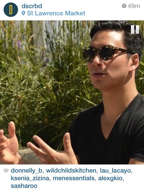
A good friend of mine recently launched a new project called DSCRBD (pronounced ‘described’). The goal is to “curate interesting minds” through short social video clips. Think Humans of New York but only creative types and only short videos.
I think it’s a great idea. And I was fortunate enough to be one of the first test subjects. It was conducted as an interview between he and I, and we spoke for probably about 45 minutes on the sun deck of my building.
He then took that entire interview and distilled it down to only a few seconds, extracting what he found most interesting. Perfect for social media consumption.
Click the image above for my video. What I’m talking about is my approach to architecture, and how I ended up not becoming an architect, but instead becoming a real estate developer.
I think he’s on to something here and I would love to see it develop further. He’s using the right mediums and format to get the message out in today’s noisy social world. But there’s also no reason that it couldn’t grow to include more content or simply feed to other content, such as what he did with Architect This City.
If you’re somebody that you think he should profile or know of someone that would be a good fit, drop him a line at hello@dscrbd.com.