Daily insights for city builders, delivered every morning at 6 AM ET. I’m Brandon Donnelly — a Toronto-based real estate developer and founder of Globizen. I’ve been writing here since 2013.

Tag: urbanism

  • The Beijing supercity

    image

    A few weeks ago I wrote a post talking about megalopolises and the importance of the Great Lakes region in North America. And I suggested that high speed rail could be one way to better stitch together the region.

    To some, I’m sure this sounded like a bit of a pipe dream. But thinking at the megalopolitan scale is something that I think we are going to need to do. Other parts of the world certainly are.

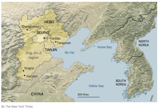
    The Chinese government is in the midst of developing a supercity around Beijing that is called Jing-Jin-Ji. It will span about 82,000 square miles and will house approximately 130 million people. 

    As part of the plan, a high-speed rail network is being built that will bring the region’s major cities within an hour’s commute. The objective is to compete with the Pearl River Delta and the Yangtze River Delta regions in the south.

    It’s a scale of planning and development that most people aren’t used to thinking about. But it’s happening right now.

    Image: New York Times

  • Rethinking the tall building

    Back in February of this year (2015), Philip Oldfield, who is an Assistant Professor of Architecture at the University of Nottingham, gave the following talk at the Illinois Institute of Technology. Click here if you can’t see it below.

    [youtube https://www.youtube.com/watch?v=lOfkx39soIs?rel=0]

    If you’re interested in cities and how tall buildings might make them more sustainable, you’ll enjoy it. It’s filled with a number of interesting stats and takeaways, and it’s about an hour long.

  • The tragedy of the commons

    https://500px.com/embed.js

    In 1968, Garrett Hardin wrote an article where he coined the term: the tragedy of the commons. Hardin was an American ecologist who was obsessed and concerned with the prospect of human overpopulation.

    In his article, the term tragedy of the commons was used to describe a situation where individuals – all acting independently and in their own self-interest – actually end up behaving in a way that is detrimental to the larger group and that negatively impacts some sort of common resource.

    Just in case, here’s another definition via Investopedia:

    An economic problem in which every individual tries to reap the greatest benefit from a given resource. As the demand for the resource overwhelms the supply, every individual who consumes an additional unit directly harms others who can no longer enjoy the benefits. Generally, the resource of interest is easily available to all individuals.

    So what would be an example of a tragedy of the commons?

    You may not have thought of it in these terms, but I bet you that everybody reading this blog has experienced one.

    I will give you two examples.

    1. The first is that of electricity consumption. 

    In most condominiums, there are two types of ways that electricity gets billed and paid. Either the whole building gets one bill (master metering) or each individual resident gets a bill (submetering). 

    In the case of master mastering, each resident’s consumption isn’t tracked and so nobody knows who is consuming what. But in the case of submetering, each individual resident only pays for the electricity that they use.

    Not surprisingly, the data shows that submetering can cut electricity consumption by 10 to 30%. That’s because it creates a 1:1 relationship between usage and cost. There’s now a strong incentive to conserve.

    With master metering, there isn’t a 1:1 relationship between usage and cost. The additional burden/cost of consumption actually gets shared by everyone else in the building. And since each individual is looking to maximize their own benefit, they lose the incentive to conserve. As a whole, this makes the entire group worse off.

    2. The second example is that of congestion on public, un-tolled roads.

    In most cities, public roads are a resource that is “easily available to all individuals” (to use Investopedia’s terminology). They are basically free. The marginal cost of driving another kilometer to work on a road is basically nothing (other than a bit of gas and some time).

    What this does is create a situation where individuals – in their pursuit of maximum individual benefit – start to overload the road. Everybody just wants to get where they need to go and there’s no incentive to conserve the resource (i.e. the road). Once again, the result is that the entire group becomes worse off.

    That’s why building more road rarely/never works. You’re simply increasing a resource that is easily available to all individuals. What we should instead be doing is looking at submetering our roads (i.e. pricing our roads). It’s been proven time and time again to reduce road congestion basically overnight.

    I had never heard of the term tragedy of the commons before today, but I like it a lot. So the next time you’re stuck somewhere in traffic, you can now scream to yourself: What a tragedy of the commons!

  • Saturday morning bike ride to the Bluffs

    This morning I got up at 7:30am and met a good friend of mine at the St. Lawrence Market for breakfast.

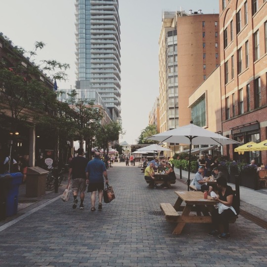
    Market Street is closed to cars today so it’s pedestrian-only. It should be this way all the time. They had a pig roasting on a spit when I walked by and a big stage set up. 

    Below is a photo of what it looks like. Keep in mind that this photo was taken just after 8:00am, which is why it’s not all that busy, yet.

    image

    When Market Street was redone a few years ago, the original vision for the street was for it to be pedestrian-only. But somebody told me that the city didn’t want that. Too bad. It strikes me as a perfect candidate for that.

    After breakfast, we then biked out to the Scarborough Bluffs in the east end of the city. If you click here, you can see the path we took via Strava. It’s only about 15km from downtown. The ride through the Beaches was by far the best stretch. The water was on my right hand side. The pavement was smooth and continuous. And I had George FitzGerald on my headphones for pacing.

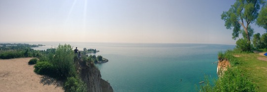
    When we got there, this was the view we were presented with:

    image

    It honestly doesn’t feel like Toronto. The water is turquoise and there’s a beautiful beach at the bottom of the cliffs. It felt like paradise.

    If you’ve never been to the Scarborough Bluffs, do yourself a favor and get out there on a beautiful summer day. It’s the dog days of summer and Toronto is a magical place right now.

  • 10 reasons to visit Toronto right now

    https://500px.com/embed.js

    Next weekend a good friend of mine from architecture school will be visiting Toronto from Philadelphia. And I’m really excited to show him the city. (Next month it’s my turn to go to Philadelphia.)

    He’s a fellow city geek. He hasn’t been to Toronto in a number of years. And I haven’t seen him since our trip to Detroit 2 years ago.

    For those of us living and working in Toronto, there’s a lot to celebrate. Sure the Gardiner Expressway East decision didn’t go as I – as well as many other urbanists, including our Chief City Planner – had hoped. But there’s no shortage of other things to brag about.

    So here are 10 reasons to visit Toronto right now:

    1. We’ve created an entirely new business district south of Union Station called South Core. Now the region’s primary mobility hub is in the middle of the country’s most important business district, as opposed to on the edge of it. It’s a better use of infrastructure.

    2. We now have a dedicated train (the Union Pearson Express) that takes you from the country’s busiest airport directly to downtown in 25 minutes. You’ll find local retailers at the stations and a brand created by the brain behind Monocle Magazine. You can even use a smart card to ride it and our local transit system.

    3. We didn’t shut down Uber. Instead our mayor wants to create new policy that will allow these services to coexist with conventional taxi services. We don’t yet know how this will turn out, but I believe it’s a step in the right direction. It’s Toronto taking a leadership approach to innovation as opposed to trying to stomp it out.

    4. We are about to host the largest sporting event in Canadian history. The 17th Pan American Games will have double the number of athletes competing as the 2010 Winter Olympics in Vancouver.

    5. We created an entire neighborhood from scratch in order to house all of these athletes (Canary District). And I think it’s destined to become one of Toronto’s great neighborhoods. I’m saving my first visit for next weekend, so expect a follow-up post on this.

    6. We are dramatically rethinking this city’s public realm. From the plaza out front of Union Station to the new Queens Quay Boulevard along the waterfront, we are prioritizing people and creating more complete streets. It has given Toronto an entirely new urban feel.

    7. We are slowly starting to embrace our forgotten laneways and alleys through the help of organizations like The Laneway Project. And this is going to eventually lead to a further rethink of our pubic spaces and urban fabric.

    8. We continue to be one of the fastest growing cities in the world (certainly in the developed world). As a result, we are building some really exciting buildings by some of the top architects in the world. This includes everyone from Norman Foster to Frank Gehry.

    9. According to a recent report coming out of the Martin Prosperity Institute, Canada is one of the most creative and globally competitive countries in the world, as well as the most open to “ethnic and religious minorities and gay and lesbian people.”

    10. The ATC community is in the process of identifying a new, quintessentially Toronto food dish. But since we have every type of imaginable cuisine here, we’re struggling to pick just one. When you visit, you can help us identify the best and most Toronto dish.

    So there’s a lot to be excited about. I for one can’t wait for us to host the Pan Am Games, starting tomorrow. It’s a chance to show off this great city. 

    So if you’re also in town next weekend and want to geek out about cities, drop me a line.

  • How urban density affects how you get around

    Yesterday I wrote about urban-suburban divides within cities. And I argued that built form will largely dictate the kinds of transportation choices that people will ultimately make.

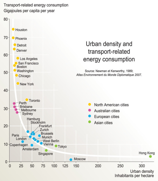
    As a follow-up to that, here is a chart based on the findings of a research report completed by Peter Newman and Jeffrey Kenworthy way back in 1989. On the x-axis is urban density (i.e. built form) and on the y-axis is per capita transport related energy consumption.

    image

    What this chart shows is that as cities become more dense, “automobile dependence” is reduced in favor of, other, more sustainable forms of transport. 

    Here we have Houston at the top left (meaning it has the highest transport-related energy consumption per capita) and Hong Kong all the way on the bottom right. Hong Kong has by far the highest density among the cities looked at in this study, but Moscow seems to have the lowest per capita energy consumption. Still, the trend appears clear.

    Some people think of “density” as a dirty word. But there are lots of benefits to dense urban centers. And density does not necessarily have to mean tall buildings.

    Chart: Globalization Studies in an Urban World (Penn)

  • Vancouver isn’t immune to the urban-suburban divide

    https://500px.com/embed.js

    In the comment section of my post about Vancouver’s transit referendum, a reader suggested I take a look at an article by Peter McMartin called, The real Vancouver emerges (from the ruins of the plebiscite)

    McMartin’s argument is basically that Vancouverism – the name given to the city’s progressive architecture and planning approach – isn’t as widespread as it might seem. The reality is that Vancouver, much like Toronto and other cities, is divided.

    “Vancouverism might be a reality for two or three neighbourhoods huddling in the downtown, and that greener, more progressive ethos might hold sway in one or two more.

    But Vancouver — and I speak of it in the metro sense — is the sum of its parts, and most of its parts are suburban in their sensibilities, and that includes not just all of the suburbs but most of the neighbourhoods in the City of Vancouver proper.

    They’re resistant to change. They abhor densification. They’re conventional in their sensibilities and they’re highly dependent on the automobile. More importantly, they’re not just dependent on the automobile, they prefer it.”

    Here in Toronto, we know our city is divided. And many people see it as evidence that amalgamating the city in 1998 was a big mistake. The inner suburbs are holding back old Toronto and elitist old Toronto just doesn’t understand the priorities of the inner suburbs.

    But I’m not convinced that amalgamation is to blame.

    Most cities have long histories of amalgamating adjacent towns, villages, and cities, and I suspect that there was opposition all along the way. At what point is amalgamation acceptable and and what point is it problematic?

    The anti-amalgamation camp here in Toronto seems to believe that it would have allowed old Toronto to continue doing what it wants to do and allowed the inner suburbs to do what they want to do.

    But this to me feels parochial.

    Our cities need to think bigger than that. We need to think as cohesive urban regions. And as Vancouver demonstrated this past week, that’s not always easy. But I don’t think the answer is to just think smaller and ignore the people whose views don’t match our own.

    Interestingly enough, what a lot of this comes down to, I think, is built form. 

    Because different kinds of built form will encourage and often mandate different kinds of transportation choices. And how you get around a city will inform a big part of what you value and what you vote for.

    Over time though, I believe that we will see built form start to level out across our city regions through continued intensification. Many people won’t be happy about this change. But it is likely that it will end up creating more cohesive cities. 

    Built form is no small thing.

  • Project Profile: 363 Yonge Street, Toronto

    image

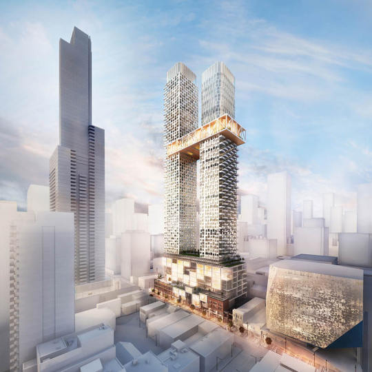
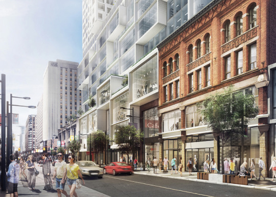
    One of the most interesting projects being proposed in Toronto right now is 363 Yonge Street, which is located downtown at the southeast corner of Yonge Street and Gerrard Street. See above hero rendering.

    The project is a two tower mixed-use development with the following stats (as per their rezoning application dated April 24, 2015):

    • 73 storey tower to the north (inclusive of podium)
    • 62 storey to the south (inclusive of podium)
    • 9 storey podium containing office and retail 
    • 887,752 square feet of residential
    • 101,062 square feet of retail
    • 186,977 square feet of office
    • Site area is 42,248 square feet (proposed density on the site works out to be about 27x)
    • 1,106 residential units – 107 bachelor (9.7%), 648 one-bedroom (58.6%), 241 two-bedroom (21.8%), and 110 three-bedroom (9.9%)
    • 289 parking spaces – 221 spaces for residents, 23 spaces for visitors, 23 spaces for retail, and 22 for office
    • 9,790 square feet of outdoor amenity space and 23,809 square feet of indoor amenity space for the residences (the “skybridge” that connects the two towers at the 51st and 52nd floors is amenity space)
    • 9,809 square feet of outdoor amenity space for the commercial spaces

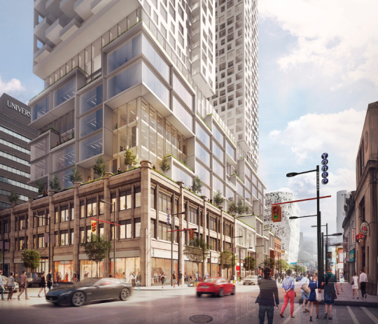
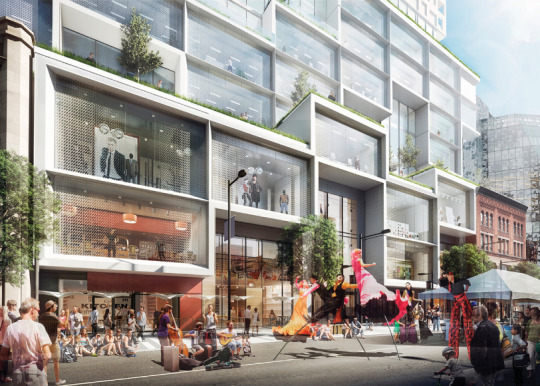
    The site also contains 2 listed heritage buildings. The Gerrard Building and The Richard S. Williams Block. The project proposes to incorporate 3 of their facades (not the entire buildings) into the base of the new development.

    Here are a few images of what that might look like at street level (going from north to south along Yonge Street):

    imageimageimage

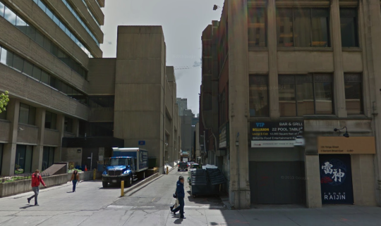
    I am also delighted to see that they are planning on adding retail to the rear laneway (O’Keefe Lane) that runs behind the site, east of Yonge Street. If you’re a regular reader of this blog you’ll know that I think Toronto’s laneways are a huge missed opportunity. So it’s great to see developers in this city starting to recognize that.

    Here’s a photo of what O’Keefe Lane looks like today (courtesy of Google street view):

    image

    Since I’ve only done one other “project profile” on this blog, I’d love to get your feedback in the comments on whether or not you find these useful.

    For those of us in the industry, it’s always valuable to look at other projects and dissect the square footages, unit mix, density, parking ratios, and so on. But I recognize that this is a particular lens.

    I’m also trying not to be so Toronto-centric, so it would be great to hear how this project compares to what you’re seeing in your city.

    All project images: Quadrangle Architects

  • With Vancouver voting “no” to transit tax, could Hong Kong now serve as inspiration?

    https://500px.com/embed.js

    Earlier today it was announced that Metro Vancouver voted “no” to a 0.5% sales tax increase that would have been used to fund a $7.5 billion regional transportation plan. 

    Roughly 62% of respondents said “no”. And not surprisingly, the percentage of people who voted “no” increased as you moved outward towards the suburbs. But even the City of Vancouver itself sided slightly with “no” at 50.81%.

    Since I’m not that plugged into the Vancouver scene, I’m not going to comment on this issue. But hopefully you all will in the comments below. I know that a lot of you are incredibly passionate about this.

    Instead, I’d like to pose two questions. 

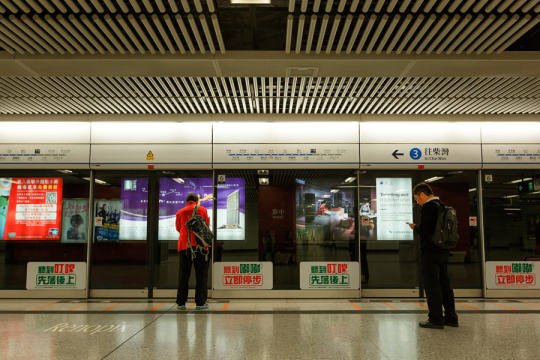
    Firstly, why is it that Asian transit operators seem to be so much better than North American transit operators at recovering their costs through fares? (Urban density and car ownership likely have something to do with it). And secondly, why hasn’t Hong Kong’s famous “rail plus property” transit model been exported to North America?

    For those of you unfamiliar with Hong Kong’s Mass Transit Railway Corporation, here’s how much money they make (via The Atlantic from 2013):

    The Mass Transit Railway (MTR) Corporation, which manages the subway and bus systems on Hong Kong Island and, since 2006, in the northern part of Kowloon, is considered the gold standard for transit management worldwide. In 2012, the MTR produced revenue of 36 billion Hong Kong Dollars (about U.S $5 billion)—turning a profit of $2 billion in the process. Most impressively, the farebox recovery ratio (the percentage of operational costs covered by fares) for the system was 185 percent, the world’s highest. Worldwide, these numbers are practically unheard of—the next highest urban ratio, Singapore, is a mere 125 percent.

    In addition to Hong Kong, the MTR Corporation runs individual subway lines in Beijing, Hangzhou, and Shenzhen in China, two lines in the London Underground, and the entire Melbourne and Stockholm systems. 

    And here’s how they do it (also via The Atlantic):

    Like no other system in the world, the MTR understands the monetary value of urban density—in other words, what economists call “agglomeration.” Hong Kong is one of the world’s densest cities, and businesses depend on the metro to ferry customers from one side of the territory to another. As a result, the MTR strikes a bargain with shop owners: In exchange for transporting customers, the transit agency receives a cut of the mall’s profit, signs a co-ownership agreement, or accepts a percentage of property development fees. In many cases, the MTR owns the entire mall itself. The Hong Kong metro essentially functions as part of a vertically integrated business that, through a "rail plus property” model,  controls both the means of transit and the places passengers visit upon departure.  Two of the tallest skyscrapers in Hong Kong are MTR properties, as are many of the offices, malls, and residences next to every transit station (some of which even have direct underground connections to the train). Not to mention, all of the retail within subway stations, which themselves double as large shopping complexes, is leased from MTR.

    I believe that we could do this too. So hopefully we can have a great discussion about it in the comment section below.

  • Teaming up to fix Toronto’s traffic troubles

    image

    “This will be a game changer and will establish Toronto as a leader in running a truly smart city.”
    – John Tory, Mayor of the City of Toronto

    Yesterday I registered for a hackathon called TrafficJam that’s taking place this October 2 – 4, 2015 here in Toronto. It’s being organized by Evergreen CityWorks and the City of Toronto, with the goal of fixing Toronto’s traffic troubles.

    Tickets are free, but going fast. If you’re interested in this sort of thing, I would encourage you to sign up today. And if you do register or are already registered, drop me on a line so we can connect. I’m excited to see what kind of solutions we’re all able to come up with over the course of a weekend.

    But as I was registering and reading through the website, I couldn’t help but think about some of the traffic problems that we won’t be solving over the hackathon weekend, namely the politicization of transportation planning in this city.

    As an example of that check out a post by transit blogger Steve Munro called, The Vanishing Relevance of SmartTrack

    SmartTrack is the transit platform that Mayor John Tory ran on last year. And this post explains why it is unlikely to achieve its pitch promises.