Daily insights for city builders, delivered every morning at 6 AM ET. I’m Brandon Donnelly — a Toronto-based real estate developer and founder of Globizen. I’ve been writing here since 2013.

Tag: urbanism

  • Los Angeles Councilman says upzoning near transit is the worst idea he’s ever heard

    Earlier this month I wrote about California Senator Scott Wiener’s bill to increase housing supply and mandate greater land-use intensities adjacent to transit. Here is that post.

    Judging by the comments, many of you seemed to think this was a fairly sensible proposal. I know I certainly did. Senator Wiener called it a housing-first agenda, as opposed to a housing-last agenda.

    So I thought it would be interesting to share how some people have responded to the proposal. 

    Los Angeles City Councilman Paul Koretz called it both “devastating” and “the worst idea [he’s] ever heard.” He went on to tell the LA Times that, within 10 years, people should expect their neighborhoods to be transformed into Dubai. 

    His conclusion: “I don’t think people want to see significant rezoning around single-family neighborhoods whether they’re near transit or not.”

    I don’t agree with his first set of remarks, but I agree with his second one. And that, of course, is the challenge. If you own a single-family home down the street from transit, what great incentive do you have to support intensification?

    Paul is the messenger.

  • Drone footage of Chicago’s riverfront

    Dezeen just published the below video of Chicago’s revitalized riverfront. The Chicago Riverwalk extension and renovation was completed in 2016 by Boston-based Sasaki Associates and Ross Barney Architects, and the video is by Chang Kim. It does a great job showcasing the city’s enviable connection to the water. If you can’t see it below, click here.

    [youtube https://www.youtube.com/watch?v=7T9xH2C-Ggk?rel=0&w=560&h=315]

    On a separate but somewhat related note, I am continually impressed by the work that is coming from filmmakers, vloggers and YouTubers like Casey Neistat and Sam Kolder (who, by the way, is from Toronto). Individual content creators continue to change the way we all consume content and, consequently, the way companies now need to market.

  • Centralized taxi branding vs. decentralized ride fulfillment

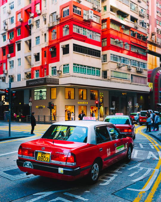
    Back in 2013, when this blog was in its infancy, I argued that Toronto needs a consistent taxi brand. Since nobody was reading the blog at the time, I am sure that most of you have never read this post. I even forgot about it, until last night when I posted this photo of Hong Kong to Instagram:

    It reminded me of the role that taxis play in city branding. This photo is clearly of Hong Kong. But take away the taxis in the foreground and I would really have to think in order to identity it. I would then be searching for street signs and looking to see what side of the road the cars are driving on.

    Now, a few things have changed since 2013. Back then I didn’t have the same appreciation for decentralized ride hailing (Uber and Lyft), though I did have the same distaste for the taxi cartel. And I recognize that there is a tension between centralized taxi branding and a decentralized approach to ride fulfillment. 

    I’m not exactly sure how to solve this problem, but maybe it gets easier with autonomous vehicles and probable changes to the way consumers own, or don’t own cars. I believe it’s important for places and cities to have specificity. If you have any thoughts, please leave a comment below. 

    (I am trying to respond to all comments on this blog, because I’m finding it impossible to respond to all blog related emails. Sorry.)

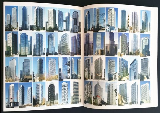
  • Multi-Unit Housing in Urban Cities: From 1800 to Present Day

    I just ordered a copy of Multi-Unit Housing in Urban Cities: From 1800 to Present Day by Katy Chey. I figured this was a book that we should have hanging around our office. I also like to support the Daniels Faculty.

    The book covers the following multi-unit housing typologies:

    • Back-to-backs in Birmingham
    • Tenements in London
    • Haussmann apartments in Paris
    • Tenements in New York
    • Tong lau in Hong Kong
    • Perimeter block, linear block and block-edge in Berlin
    • Perimeter block and solitaire in Amsterdam
    • Space-enclosing structures in Beijing
    • Kyosho jutaku in Tokyo
    • High-rises in Toronto

    In addition to each typology, the book analyzes the connection between the housing type and the city. Why did certain typologies flourish where they did and how have they helped to define their city?

    It reminds me of what I was trying to do with some of my recent posts about Hong Kong’s typical tower plan, albeit with far less rigor than what I am sure has been applied to this book.

    I am also curious to read what has been written about high-rises in Toronto. It goes to show you just how defining the current real estate cycle has been for this city. That’s our multi-unit housing typology.

    Image: Daniels Faculty. My multi-unit home made the book.

  • Why east sides are often poorer than west sides

    In a recent Spacing article, called Pollution and the fall and rise of urbanism, Dylan Reid argues that one of the reasons why urbanism declined in the 20th century was because of industrial pollution. (There are, of course, other contributing factors beyond just pollution.)

    This article is the first time I have come across a study supporting the widely held belief that pollution and prevailing windows are the reasons for why the east sides of many former industrial cities are poorer than the west sides. Here is more on that from the article:

    People recognized and understood that pollution had an impact on them, and they tried to avoid it if they could afford to do so. Have you noticed, for example, how in so many cities (Toronto included), the east side is poorer than the west side? It’s because the prevailing winds in Europe and North America are west to east, and they blow pollution to the east side. A fascinating study by economists Stephan Heblich, Alex Trew and Yanos Zylbergerg quantified this effect, identifying how 19th century pollution was dispersed eastwards and showing that the most polluted areas were also the poorest. 

    What the authors discovered is that not only did pollution cause a geographic sorting based on wealth, but that there’s also a certain degree of persistence to it. This makes sense if you think about it. Pollution in our cities has waned significantly and yet here we are still remarking and talking about east vs. west.

    It goes to show you just how long lasting the impacts of our city building decisions can be.

  • How should mid-sized cities really compete?

    Jennifer Keesmaat – the former chief planner of Toronto – recently published an article in Maclean’s called: Toronto’s unaffordable. Why can’t Halifax or Saskatoon take advantage? Her argument: 

    “The hard truth is that many mid-sized cities won’t win the future because they are stuck on a suburban growth model. If the future is green and walkable, they will be left behind.”

    The model city that is held up is Portland – a terrific mid-sized city of only 640,000 people that has used progressive land use policies to build a livable and dense urban center. (In all fairness, the Portland MSA has over 2.4 million people.)

    Now, if you’re a regular reader of this blog you’ll know that I have a penchant for dense urban centers. I live and I work downtown. And I would happily trade square footage for a more sensible commute and lower transportation costs.

    But after I read the article, I couldn’t help but think that progressive land use policies, alone, aren’t enough. Cities, like social networks, experience network effects. That’s why there’s so much talk these days of winner-take-all urbanism.

    All of this is not to say that progressive urban policies are a bad thing. Quite the opposite. I just think there are many other factors at play if we’re talking about taming the hegemony of our global cities.

  • Amazon’s cashier-less grocery store finally opens

    This morning the first Amazon Go store opened to the public in downtown Seattle. It’s more convenience store than grocery store, but the big deal is that there are no cashiers and no lines.

    You enter the store through a gate and with your phone and Amazon’s app. As you walk around the store and pick up items they get automatically added to your online cart on Amazon.

    So everything goes right into the offline bag you’ll be leaving the store with. Place an item back on the shelf and it is instantly removed from your “cart.” Walk out of the store and you’re automatically charged.

    It’s not yet clear how exactly the technology works, but Amazon says that all of this is accomplished through sophisticated computer vision (cameras), machine learning, and lots of sensors. 

    What’s really remarkable is that it doesn’t rely on every product having a special chip or sensor attached to it. I would think that was one of the biggest hurdles to overcome in order to remove the pain point of grocery store lines.

    Now that this is up and running, I can only imagine the customer behavior data that they must be collecting. Heat maps of every shelf showing conversion rates for every imaginable customer segment. (Are tall people more likely to buy products displayed higher up?) Correlating people’s food purchases to their broader Amazon shopping habits. And the list, I’m sure, goes on. 

    There is even speculation that Amazon will begin licensing this technology to other retailers, similar to what it does with Amazon Web Services. That seems like a reasonable assumption given the data play we just talked about. Assuming the tech works, it’ll get copied. So they may as well embed themselves.

    In case you were wondering, the Bureau of Labor Statistics pegs the number of cashiers in the US at about 3,555,500 (2016 number).

    And this number is projected to remain more or less flat until 2026.

    That doesn’t feel right to me.

  • My even shorter Amazon HQ2 shortlist

    Amazon released its shortlist of HQ2 cities this morning. Below are the 20 metropolitan areas. They were selected from 238 bids, so this shortlist represents 8.4% of the original pool.

    • Atlanta, GA
    • Austin, TX
    • Boston, MA
    • Chicago, IL
    • Columbus, OH
    • Dallas, TX
    • Denver, CO
    • Indianapolis, IN
    • Los Angeles, CA
    • Miami, FL
    • Montgomery County, MD
    • Nashville, TN
    • Newark, NJ
    • New York City, NY
    • Northern Virginia, VA
    • Philadelphia, PA
    • Pittsburgh, PA
    • Raleigh, NC
    • Toronto, ON
    • Washington D.C.

    I saw some people on Twitter say that they were surprised to see Toronto and Miami on this list. I was not. If you remember, I publicly predicted on this blog that Toronto would be selected for Amazon HQ2.

    That said, I thought it would be fun to guess at an even shorter list from Amazon’s shortlist. I have no knowledge of Amazon’s actual selections process, but if I had to guess, here is who I would cross off the list:

    • Atlanta, GA
    • Austin, TX
    • Boston, MA
    • Chicago, IL
    • Columbus, OH
    • Dallas, TX
    • Denver, CO
    • Indianapolis, IN
    • Los Angeles, CA
    • Miami, FL
    • Montgomery County, MD
    • Nashville, TN
    • Newark, NJ
    • New York City, NY
    • Northern Virginia, VA
    • Philadelphia, PA
    • Pittsburgh, PA
    • Raleigh, NC
    • Toronto, ON
    • Washington D.C.

    That leaves us with a list that looks like this:

    1. Boston, MA
    2. Miami, FL
    3. Montgomery County, MD
    4. Newark, NJ
    5. Northern Virginia, VA
    6. Toronto, ON
    7. Washington D.C.

    So why this list? I’m probably wrong, but my reasons are as follows:

    – I think Amazon will opt for a metro area on eastern time.

    – There seems to be a predilection for areas around Washington D.C., so I left Montgomery County and Northern Virginia. 

    – As wonderful as it is, New York City feels too center ice for Amazon – at least in my view. But maybe Newark places them in the catchment area.

    – The area needs to be of a certain scale so Amazon doesn’t overpower it and they have enough human capital to draw from.

    – Miami is my sleeper bet. Most people think of it simply as a resort town, but there’s a huge percentage of foreign born residents and powerful arts/design scene.

    – Talent is number one, which is why I left Boston and Toronto and why I continue to believe in Toronto. Toronto is more dynamic than Boston.

    If I had to pick just three from the above shortlist, my bets would be, in alphabetical order: Boston, Toronto, and Washington D.C. What are yours?

  • It doesn’t matter what Bitcoin is trading at right now

    Steven Johnson has a terrific piece in New York Times Magazine called: Beyond the Bitcoin Bubble. Here is a snippet:

    The only blockchain project that has crossed over into mainstream recognition so far is Bitcoin, which is in the middle of a speculative bubble that makes the 1990s internet I.P.O. frenzy look like a neighborhood garage sale. 

    But the point of the article, as its title suggests, is to talk about what all of this craziness could mean for the future of the internet and how, in some ways, it could be a return to what the internet was always intended to be.

    The real promise of these new technologies, many of their evangelists believe, lies not in displacing our currencies but in replacing much of what we now think of as the internet, while at the same time returning the online world to a more decentralized and egalitarian system. If you believe the evangelists, the blockchain is the future. But it is also a way of getting back to the internet’s roots.

    Some are calling this new, decentralized internet version 3.0. We are currently living with internet 2.0. Practically speaking though, what could this shift really mean for us?

    One example that is given in the article has to do with urban mobility – a topic that is particularly relevant to this audience. 

    Internet 2.0 has created a winner-take-most economic model. And in the case of mobility – at least in the world of apps – that winner is Uber. But with internet 3.0 and the blockchain, this could be possible:

    Just as GPS gave us a way of discovering and sharing our location, this new protocol would define a simple request: I am here and would like to go there. A distributed ledger might record all its users’ past trips, credit cards, favorite locations — all the metadata that services like Uber or Amazon use to encourage lock-in. Call it, for the sake of argument, the Transit protocol. The standards for sending a Transit request out onto the internet would be entirely open; anyone who wanted to build an app to respond to that request would be free to do so.

    Cities could build Transit apps that allowed taxi drivers to field requests. But so could bike-share collectives, or rickshaw drivers.

    I don’t know about you, but I find this perspective a lot more interesting. I recommend you read Steven’s article. It will help you cut through a lot of the Bitcoin noise.

  • Where the young and educated are moving to in the US

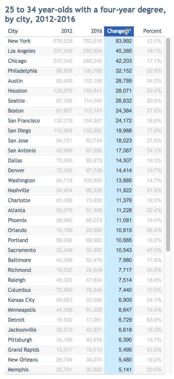
    City Observatory tracks something that they call “The Young and Restless.” It refers to the segment of the US population that is between 25-34 years old and has a bachelor’s degree or higher.

    We know that people in this age bracket tend to be relatively mobile and that the likelihood of moving decreases as people age. So it’s a potential leading indicator for the city regions of the future. It also adds a bit more nuance to the urban vs. suburban growth debate. 

    According to City Observatory, between 2012 and 2016 the number of 25 to 34 year olds with a 4-year degree living in one of the 53 largest largest cities in the US increased by 19%. This is compared to a 4% increase in the overall population in these cities.

    This increase in young well-educated adults is also happening 50% faster in the largest cities. So the young and educated still seem to be demanding city living, even if the world is arguably still suburbanizing.

    Below is a snapshot of City Observatory’s latest data. I’ve sorted the list by total change in population (2012 to 2016). Happy to see Philadelphia near the top. If you do it based on percentage, Detroit wins with a 64% increase.

    For the full list of cities, check out City Observatory.