Daily insights for city builders, delivered every morning at 6 AM ET. I’m Brandon Donnelly — a Toronto-based real estate developer and founder of Globizen. I’ve been writing here since 2013.

Tag: urban

  • Toronto’s great streets

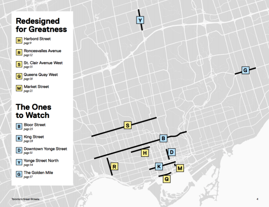
    Last week the Ryerson City Building Institute published a terrific report on Toronto’s Great Streets. It profiles five streets in the city that have been “redesigned for greatness.” They are:

    • Harbord Street (continuous bike lanes)
    • Roncesvalles Avenue (placemaking and people)
    • St. Clair Avenue West (dedicated streetcar lane)
    • Queens Quay West (public waterfront promenade)
    • Market Street (prioritized for people and patios)

    But what exactly makes a street a great one? The report describes it in this way: “They all play a key role in making the surrounding neighborhood a great place to live, work, and visit.”

    This relates closely to what the City of Toronto calls a “complete street”, which is an approach to accommodating multiple kinds of users, enhancing the local context, and determining which trade-offs to make.

    And there will always be trade-offs. I am fairly certain that all of these street redesigns were contentious at the time when they were proposed. Because at the end of the day they will never be all things to everyone.

    I remember the St. Clair West fight vividly because I moved to the neighborhood in 2009 and the dedicated streetcar lane didn’t fully open until 2010. From 2005 to 2017, streetcar ridership grew 23%. But drivers have remained grouchy.

    I now walk Market Street every single day and I agree that it’s one of the most beautiful and functional streets in the city. But the bollards are constantly getting beat up by drivers attempting to parallel park and the retail vacancy rate has not been 0% like is suggested in the report.

    Queens Quay West is also a magnificent street. It was a giant step forward in terms of the quality of the public realm in this region and I spend a lot of time there. But it’s of course not perfect. All of us have seen the reports of cars ending up in odd locations, including underground, along the waterfront.

    Riding your bike there can also feel like a challenging game of Frogger with all of the pedestrians that now obliviously meander back and forth across the cycling trail. I suggest riding with a good blow horn. The report rightly mentions the lack of delineation between these users.

    But cities are a living laboratory and none of these streets should now be considered static. We are fortunate to be in a position to critique levels of greatness. If anything, the map at the top of this post tells me that we need to create more greatness across the other areas of this city.

  • From country club to urban basecamp

    CityLab recently published an article talking about the difficult time that golf-centric country clubs are having in attracting young people (and minorities and women). Their reasoning is that Millennials are saddled with student debt and can’t afford the fees; Millennials find these sorts of clubs stuffy and overly formal; and Millennials are put off by the long history of these places being only for rich white males.

    The result is that golf and country club memberships are down about 20% since 1990. In the 90s there were more than 5,000 full service clubs of this type in the US. And today it’s somewhere south of 4,000. In the 90s, about 9 million people aged 18 to 34 played golf (again in the US). And today that number is somewhere around 6.2 million. All stats taken from the article.

    But at the same time, the article argues that Millennials may still like country clubs, they’re just about 10 years behind because of higher education, travel, and delayed family formation. The article also talks about the rise of private clubs like Soho House, as well as others. And so here’s one counter argument: Millennials are open to private clubs and many have the means. They just want them to be, well, cooler and more urban.

    As a young person who largely fits within the trend line described in the CityLab article, my gut tells me that this is largely a case of changing consumer preferences and urbanizing wealth. That’s why we’re seeing established country club operators open up “urban basecamps.” But that’s my view. What is yours? Let us know in the comments below.

    Photo by Andrew Rice on Unsplash

  • More on One Delisle and the block

    image

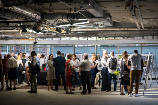
    Now that things have quieted down from last night, I would like to say that we are thrilled by the response to One Delisle and the broader ideas for the block. There was a lot of positivity last night at the open house and today the project team received countless emails and messages from people telling us that they are excited and/or looking forward to working with us over the coming years. Many were from the local community.

    image

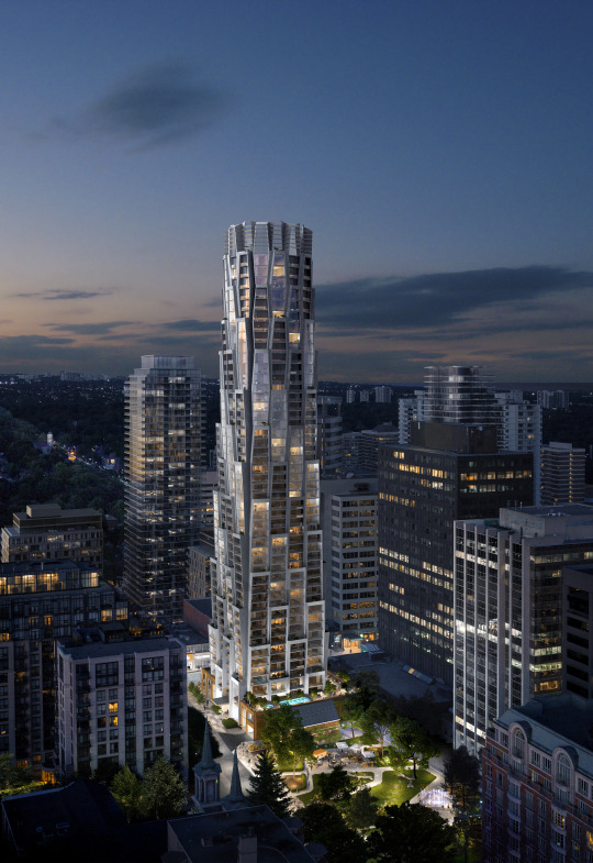
    Following yesterday’s Globe and Mail piece by Alex Bozikovic, One Delisle was also covered in Urban Toronto (read the comments), designboom (they’re allergic to capital letters), ArchDaily, Canadian Architect, Dezeen, The Architect’s Newspaper, and probably other places that I am missing. The comments have been interesting to read and there seems to be a fatigue around boring glass boxes. This project team does not want to do that.

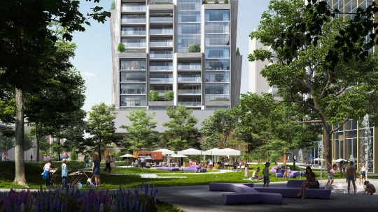
    Though the project has been making the rounds, there are two images that I don’t think have been widely shared and so I would like to do that today (below). Both were presented at last night’s open house. And they are intended to show the relationship between One Delisle and Delisle Park, which is proposed to be revitalized and expanded by ~50% as part of the project’s block and enhanced public realm strategy. Credit to ADHOC Studio for these renderings.

    imageimage

    In fact, it is important to keep in mind that while a lot of attention is being paid to the architecture of the building, there’s a broader city building strategy that is attached and integral to it:

    • Revitalize and expand Delisle Park by 50%
    • Add residential uses to a block of office buildings
    • Reduce the number of vehicular access points across the block from 5 to 3 in order to improve traffic flows in the area
    • Create below-grade vehicular connections across the block to consolidate and legitimize access/loading and once again improve traffic flows in the area 
    • Significantly widen the sidewalk along Yonge Street to eliminate existing pedestrian pinch point
    • Significantly widen the sidewalk along Delisle Avenue to strengthen connection to Delisle Park
    • Introduce pedestrian laneway with art canopy to connect St. Clair Avenue West back to Delisle Park
    • Create a unified and consistent public realm across the block and provide retail animation along its edges
    • Retain Art Deco facade along Yonge Street
    • Target the 2nd tier of the Toronto Green Standard (voluntary sustainability target)
    • Continue to explore the feasibility of district energy solutions across the block to take advantage of the different energy demand curves for office, retail, and residential uses

    Once again, a big thanks to the ~300 people who came out last night – in the rain – to engage with the project team. And a big thanks to the full project team who worked tirelessly to prepare for this week’s community open house. But as was said on Thursday night, in many ways this is really just the beginning. To stay informed about the project and to provide your feedback to the team, stay tuned to yongedelisle.ca.

    Photos: Khristel Studios

  • Inaugural meet-up: Planners on bikes getting coffee

    Remember my post from a few weeks ago about “planners on bikes getting coffee?” Well it happened. That’s the potential of blogging and Twitter. (I sold $TWTR too early.) 

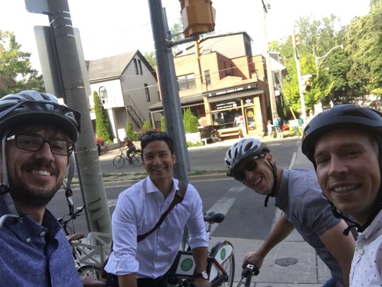
    Here is the selfie to prove it:

    Jason Thorne and I met up with Gil Meslin and Liam Hanebury (Liam needs Twitter) of Artscape and they toured us around a few of their projects, including one of their first artist live/work projects on Queen West.

    I do, however, have to confess that we didn’t have any coffee. I can’t drink coffee in the evening because it keeps me up at night. I already have too many things on my mind.

    Trying to hold a group conversation on a bike is also not as easy as talking in a car, but I would still label the inaugural session a success, even if I was posing as a planner without a bicycle helmet.

    If any of you have any suggestions for the next meet-up or I would like to join, drop me/us a line on the Twitter machine.

  • Toronto: 2000 vs. 2025

    Last week, Joe Berridge, Partner at Urban Strategies, gave a presentation at the Institute on Municipal Finance & Governance titled, Toronto: The Accidental Metropolis. I’ve seen Joe give similar presentations to this one before, and I always thoroughly enjoy his focus on Toronto’s position as a global city.

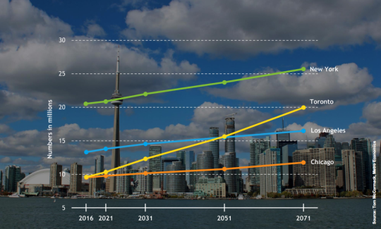
    Here is a slide from the presentation that projects out Toronto’s population to 2071 and compares it to the largest cities in the US.

    image

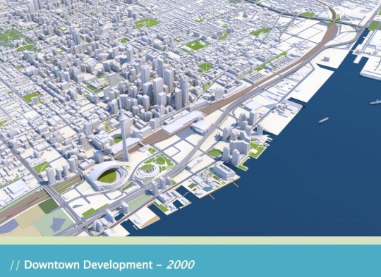
    But the two slides that have been really making the rounds online are the following ones. The first is a rendering of what downtown Toronto looked like in 2000. 

    image

    I remember this time clearly. Queen West seemed to end at Spadina. King West and Ossington weren’t things. And “Richmond and Adelaide” felt like the greatest club district in the world. (If you’re not from Toronto, these references will likely mean nothing to you. Sorry.)

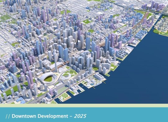
    The second slide is a rendering of what Toronto will look like in 2025. The transformation is just incredible.

    image

    I’ve seen some people comment that the Toronto of 2000 was relatively affordable; the Toronto of 2018 is unaffordable; and the Toronto of 2025 will be even more unaffordable with all of this new development.

    But I don’t understand that logic. Considering the growth rate shown in the first slide, imagine how unaffordable this city would be if we weren’t building new places for people to live and new places for people to work.

    For the full slide deck, go here. And for recent aerial photos of Toronto’s downtown core, check out my Instagram page.

  • What to do about Hong Kong’s land supply problem?

    My friend Jeremiah shared this ULI article with me this morning, which talks about Hong Kong’s land supply problem. The interesting thing about this problem is that only 9.3 square miles of the city’s land (out of ~424 square miles) is actually developed (and about 60% of the region’s area is water). The rest has been preserved for parks, farmland, and so on. And that is certainly a remarkable characteristic of Hong Kong. It doesn’t take very long to escape its hyper-urbanism and be in the countryside.

    Preserving greenspace is of course vital. But at what point do population and growth pressures justify the unlocking of some of that land for development? This is the question that Hong Kong appears to be asking itself. At the same time, it is looking at developing other islands (such as Lantau, which I understand is a pretty lush place); reclaiming (i.e. creating) additional land; and positioning the city as part of a planned “Greater Bay Area.” 

    If it were up to you, how would you suggest that Hong Kong deal with these pressures? The city is already fairly adept at building up.

    Photo by Annie Spratt on Unsplash

  • Shift toward the center

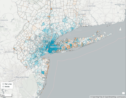
    The New York City Department of City Planning has a very cool “metro region explorer” online that allows you to explore population, housing, and employment trends in the tri-state NYC Metropolitan Region. Start here and then click on “Learn More” to cycle through the slides and data.

    One interesting takeaway is that population growth continues to centralize in the region’s core. Since 2010, 60% of the region’s population growth has taken place in the five boroughs of New York City, and in particular it has occurred in neighborhoods with strong rail transit.

    There has also been a slowing in terms of the number of residents leaving New York City. Historically, people moved to the city in their 20′s and left in their 30′s. That trend is slowing.

    I suspect this has to do with a combination of factors, including the shift toward a city-centered knowledge economy; the desire for walkability and urban amenities; the phenomenon of people getting married later in life (if at all); and so on.

    The people who do leave the city are also more likely to leave for other parts of the U.S. than other parts of the region. This has led to a decline in the number of prime age (25-54 years old) workers in the suburbs.

    Check out the Metro Region Explorer, here. There’s a lot of good stuff in there.

  • Meet Replica

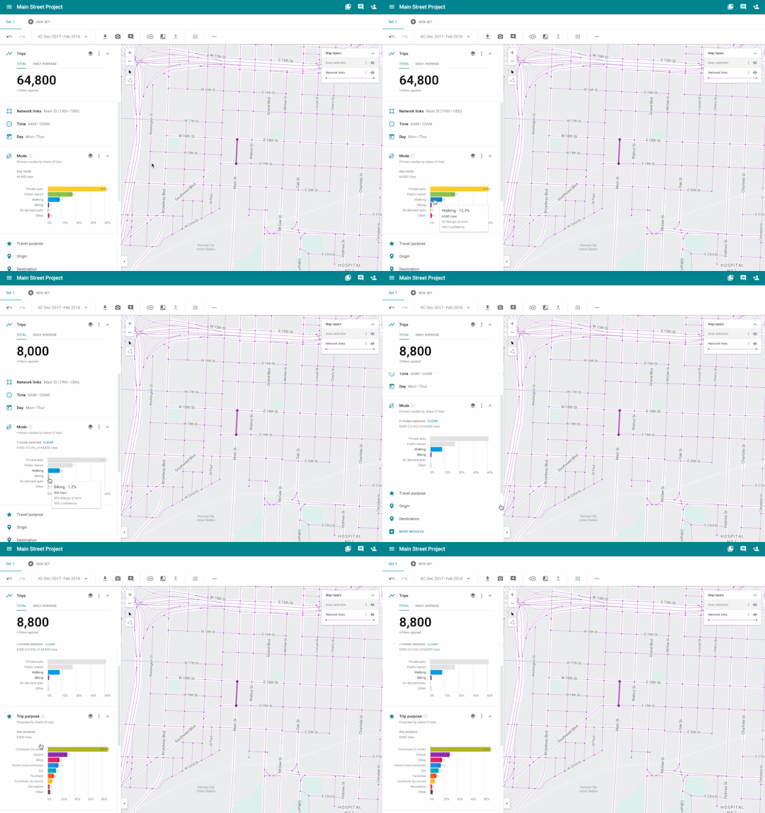
    Sidewalk Labs is currently building out a platform called Replica that will support them in their development plans here in Toronto. Replica is

    “a user-friendly modeling tool that uses anonymized mobile location data to give planning agencies a comprehensive portrait of how, when, and why people travel in urban areas.”

    Here is a preview of the Replica dashboard showing a section of Main Street in Kansas City. I hope the animated GIF shows up for you.

    The platform uses a combination of mobile location data (~5% of the population) and on-the-ground checks, typical stuff like manual traffic counts and transit boardings.

    The goal is to understand in real-time who is using a street, as well as how (driving? cycling?) and why (going to work?).

    Their introductory blog post obviously stresses the importance of personal privacy, but I am curious how they determine where people are going.

    I suppose if they pair journeys with destinations (and the durations at those destinations) they can make reasonable assumptions around the why.

    I think the benefits to all of this are clear. But does any or all of this worry you from a privacy standpoint?

  • The 100 million city

    The Guardian recently published this reminder that the real population growth in the world today is happening in Asia and Africa. The article is called, “The 100 million city: is 21st century urbanisation out of control?” Much of the data is from this 2016 paper by Daniel Hoornweg and Kevin Pope, which projected the populations of the world’s biggest cities by 2100.

    The standout example is that of Lagos, Nigeria, which went from under 200,000 people in the 1960s to an estimated 20 million people today. Though, I would imagine that the ubiquity of informal settlements makes it difficult to come up with an accurate number.

    Still, it is one of the world’s top 10 largest cities and, by 2100, it may be the largest city in the world. The Guardian described the population as young, fertile, and increasingly urban. The median age in Nigeria is 18 and the fertility rate for the content is 4.4 births per woman.

    I am mentioning all of this today because I think it grants some perspective. This is an immense city building challenge, not only because of the unprecedented growth rate, but also because it remains largely poor. Lagos, a city, may add more than 2.2x the population of Canada, a country, during the balance of this century.