
Daily insights for city builders, delivered every morning at 6 AM ET. I’m Brandon Donnelly — a Toronto-based real estate developer and founder of Globizen. I’ve been writing here since 2013.

Tag: urban form

  • A line vs. a circle — which is the optimal urban form?

    So I guess I was wrong. I thought “The Line” in Saudia Arabia was never going to be built — at least not in its current incarnation. But apparently it is now under construction, and it is still planned to be 170 km long and house some 9 million people when it’s complete. I suppose something could happen between now and when all 170 km are complete, but I’m happy to accept that, for the time being, I was wrong.

    Now it’s time to ask ourselves what a 170 km long city would even be like. To answer that, here is a fascinating article from npc Urban Sustainability describing how mobility and urban interactions are likely to work in this kind of a linear city. And it turns out that a line is actually an optimal urban form if you’re trying to both maximize commute times and maximize the average distance between inhabitants:

    One of the most critical aspects related to The Line is distance. If its 9 million inhabitants are homogeneously distributed in the city, each km will have roughly 53,000 people. If we randomly pick two people from the city, they will be, on average, 57 km apart. Although The Line occupies only 2% of the surface of Johannesburg, if we pick two random people in Johannesburg, they are only 33 km apart. Keeping the surface fixed, a line is the contiguous urban form that maximises the distance between its inhabitants. In The Line, people are as far away from others as possible. Considering that a walkable distance is 1.0 km, in The Line, only 1.2% of the population is at walking distance from others. Active mobility is not viable in The Line since distances are too long. The plan for The Line has no cars but also gets rid of most active mobility. Although in The Line, basic needs could be satisfied within 5 min, most journeys to school, work, leisure or visiting other people will depend on public transport.

    So what would be better? Well if you’re trying to minimize the average distance between people and increase urban interactions, then the optimal form is generally the one that cities have been using ever since they were first created:

    We can think of a city called The Circle, where we take the same tall buildings as in The Line but put them next to each other, forming a circular shape. A circle that occupies the same surface as The Line (34 km2) has a radius of only 3.3 km. In The Circle, the expected distance between two random people is only 2.9 km. In The Circle, a person is at a walking distance of 24% of the population (and within 2 km, they could reach 66% of the destinations), so most of their mobility could be active. In The Circle, a high-speed rail system is unnecessary since people could walk or cycle to most places, and buses could supply the rest of the journeys. The Circle occupies roughly the same surface as Pisa, Italy, but has 50 times its population. A round urban form is the most desirable since it reduces commuting distances and the energy required for transport.

    This is one of the challenges with building large scale cities from scratch. It’s easy to become enamoured with a particular plan or symbol; whereas in reality, cities don’t care about these kinds of visual representations. They don’t care that, in plan, the city may look like an eagle (see “Helicopter Urbanism“, a term that was supposedly coined by Jan Gehl). What matters is how interactions between humans play out at street level.

  • Decentralization, centralization, and new frontiers

    In this recent post by Naval Ravikant, he argues that innovation seems to like two things: decentralization and a frontier. He starts by giving the examples of more decentralized states (i.e. smaller federal governments) and the Wild West. The American frontier was, as you know, wild. But it was also a place of great innovation.

    Naval then goes on to talk about the pendulum that tends to swing between centralization and decentralization. And in the world of technology, the last decade has been one of centralization (big companies). But this pendulum is much broader. Cities, as we have talked about before on this blog, are constantly in tension between centralizing and decentralizing forces.

    COVID was a powerful decentralizing force for cities. Everything was closed and we were all supposed to stay home. And so most/all of the benefits of centralizing in a city were suddenly, yet temporarily, turned off. Many people naturally decentralized. But when the dust finally settles, I highly doubt it will be as dramatic as most people initially thought.

    We know that cities and urban density encourage innovation. That’s why “unicorns” tend to overwhelmingly originate in big cities. But here’s the thing: this is a form of centralization. The fact that cities even exist in the first place tells us that their centralizing forces are winning out over the decentralizing ones.

    So how do we reconcile this with Naval’s argument that new frontiers and decentralization are actually what are needed for innovation? I agree wholeheartedly that one of the key innovations with crypto, for example, is that it is decentralized and permissionless. But what does this ultimately mean for cities and our built form?

    Does it encourage a similar sort of decentralization to happen? Or is the irony that decentralized technologies actually still thrive in centralized urban places? We may all be online buying NFTs, but we still want to get together in person to show them off and exchange ideas.

  • The spatio-temporal hierarchy of urban form

    I was recently introduced to the work of Brenda Case Scheer – specifically a journal article she wrote called The Anatomy of Sprawl. If you’re the kind of person who enjoys geeking out about cities, this is for you. (Thank you Oliver.)

    What she does in the article is break down the various components / layers of a city according to the rate in which they change. Her “spatio-temporal urban hierarchy” includes: site (slowest rate of change), superstructure, infill, buildings, and objects (fastest rate of change).

    The way to think about this is that the bottom layers of a city – the paths and roads we have chosen to establish – are incredibly persistent. They don’t change all that often.

    On the other hand, buildings do change. Old ones get demolished. New ones get built. There’s a cycle. They too probably feel pretty persistent in many cases, but in comparison to our roads, they change far more frequently.

    The reason why all of this has bearing is because the paths we choose to carve out at the very beginning will ultimately dictate the kind of city that gets built and rebuilt over time.

    The rectangular grid of Manhattan was planned out in 1811. Central Park was missing from this original plan, but it did establish the street network and ownership lots that are now so central to the identity of New York City. That was a 200+ year decision.

    It seems to have worked out just fine for New York. But what if you’re in a position where the existing street network is viewed as failing and/or inappropriate for the future success of the city? 

    Well that’s where things get interesting. Now you need to dig down to some of those base layers and work on changing the (frequently) unchangeable. 

  • How are you being shaped?

    image

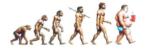
    “We shape the cities, and then our cities shape us.” That’s one of my favorite lines from the documentary The Human Scale, featuring Danish architect and urban designer Jan Gehl. I like it because I don’t think many of us think enough about the way in which the built environment – that we create – ultimately goes on to influence the way we live our lives.

    One of the most interesting connections for me is the link between urban form and public health. There’s been a lot of talk over the years about how suburban sprawl is, or might be, making us fat (among other things). We’ve created environments that are only navigable by cars and that has forced many of us into sedentary lifestyles. We sit in our cars, and then we sit in our offices.

    So today I’d like to conduct a bit of a poll. If you’d like to participate, please share the following 3 things in the comment section below: 1) your city, 2) the type of neighborhood you live in (urban, suburban, rural, etc.), and 3) the amount of time you spend walking or doing something active on an average day.

    Here’s me:

    I live downtown Toronto in the St. Lawrence Market neighborhood (urban). I take the subway to work and the station is a 10 minute walk from my place. So as a bare minimum, I spend at least 20 minutes a day walking. But since I also walk to do most of my regular errands, and since my gym is another 10 minute walk from my place, I’d say I average a good 30-45 minutes of walking each day.

    Now it’s your turn 🙂

    This is a pretty crude survey, but with the advent of things like smartwatches and health monitors, I think we’ll soon have lots of great data on the ways in which our cities might shape our health.

    Image: The Economist