Daily insights for city builders, delivered every morning at 6 AM ET. I’m Brandon Donnelly — a Toronto-based real estate developer and founder of Globizen. I’ve been writing here since 2013.

Tag: urban design

  • Show Yonge some love

    image

    Since last summer the Downtown Yonge Business Improvement Area in Toronto has been running a really creative community engagement program at yongelove.ca.

    The site includes a short history of Toronto’s most famous street, an Instagram contest (use #YongeLove to participate), and a survey where both locals and visitors can provide their feedback on what they think the future of Yonge Street should be.

    The reason this is being done is because, in 2016, Yonge Street from Davenport Road all the way south to the lake will be ripped up for infrastructure upgrades. And so it was rightly determined that now is the right time to rethink the future of Yonge. Let’s do this once.

    I’ve already talked about the Yonge-Redux proposal here on Architect This City and that seems to be where everyone’s head is at in terms of what they would like to see. I also think it’s the right thing to do for Yonge Street. If you’ve ever been on Lincoln Road in Miami or La Rambla in Barcelona, you’ll know how magical a great street can be.

    So I’d encourage you to complete the Yonge Love Survey and advocate for something awesome. It ends next month, after which time all the feedback will be forwarded to the city.

    I’d also love to hear what you think and how you responded in the comment section below. My response was more or less geared towards supporting the Yonge-Redux proposal.

  • What the largest real estate development project in the United States looks like

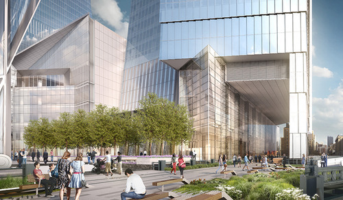
    Urban Land Magazine recently published an interesting article on the Hudson Yards project in New York, which is the largest private real estate development project ever undertaken in the United States. Click here for the article. Thanks to my friend Evan Schlecker for passing it along. It’s a good read.

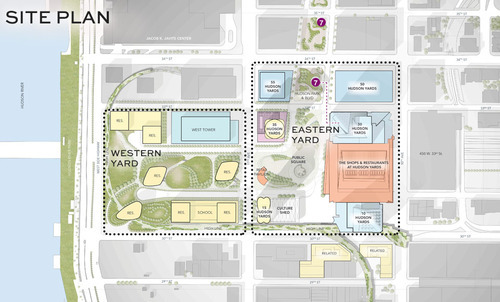
    The project is being co-developed by Related out of New York and Oxford Properties out of Toronto, and when it’s all said and done, it’ll be over 17 million square feet of commercial and residential space. It’s a $20 billion development project. 

    But beyond just being massive and epic, there are a bunch of other things that make this project unique. You can read about them all in Urban Land, but I’d like to share a few snippets with you all here:

    The first is about the project’s placement on top of a rail yard:

    In order to make use of a site already occupied by a working rail yard—including more than 30 tracks for the Long Island Rail Road and three train tunnels, with a fourth under construction—most of the development will be built atop two steel-and-concrete platforms. That base, and the buildings on it, will be supported by hundreds of concrete-filled caissons, which will be drilled between the rail lines into the bedrock.

    Because the location of the tracks and tunnels limits the placement of caissons, only 38 percent of the site can be used to support buildings.

    The second is about the project’s use of technology:

    Beyond that, a vast number of sensors embedded in the site’s infrastructure will collect mountains of data on everything from temperature and air quality to pedestrian and vehicle traffic. That information, which will be scrutinized in real time by managers in an effort to fine-tune Hudson Yards’ operation, will also be shared with New York University (NYU) researchers, who will turn Hudson Yards into a laboratory for studying urban life and finding ways to improve its quality.

    And the last one is about how it interfaces with the High Line (click here if you don’t know what that is):

    Pedersen [of Kohn Pedersen Fox Associates] found an intriguing way to address the building’s surroundings. He allowed the High Line—a public park built on a historic freight rail line elevated above the West Side—to penetrate underneath the tower through a 60-foot-long (18.3 m) public passageway, so that the building will interact with the park and its visitors. Inside the building, a dramatic atrium “becomes the terminus of the High Line as it moves from south to north,” he says.

    So there are a lot of interesting and exciting things going on with this project. What’s amazing though is how “vertical” this community will be. You have rail lines below grade. Platforms on top. Retail at grade and across multiple levels. And an elevated linear park cutting through the buildings. Not every city can make this work. New York can.

    Images: Hudson Yards New York

  • Q&A on reimagining public spaces

    I received an email from an ATC reader yesterday who is working on a publication about reimagining public spaces in Toronto. She sent me a few questions and specifically wanted to talk about the Yonge Redux project, which I wrote about a month ago. After I responded to her questions, I figured I should just share them publicly. So here they are:

    How would citizens from different age groups benefit from the Yonge Redux project?

    I would bet you that this stretch of Yonge Street experiences more pedestrian traffic than it does car traffic. And yet we’ve allocated space in the opposite direction: cars have more space than pedestrians do. So what this project is really about is reallocating the street, or public right-of-way, so that the dominant uses are actually prioritized through urban design. It doesn’t need to be more complicated than that. Ultimately, this will benefit people both young and old.

    Do you know what kind of professionals are needed to complete a project like this?

    You’d need an architect/designer – one who is awesome at landscape/urban design work. gh3 here in the city comes to mind as a firm I like, if you want an example. You’d need a bunch of engineers to deal with stormwater management and other infrastructure items. You’d likely need a transportation/traffic consultant to assess traffic flows in the area and prove that this project won’t cause the entire city to come to a grinding halt (it won’t). You would need someone to manage the day-to-day of the entire project. And this is just naming a few of the professionals/consultants that you’d probably end up needing.

    You’d also have to work closely with the city, the local councillor, and the local community. It’s inevitable that some of the businesses will worry about the loss of potential customers – so that would need to be worked through.

    What are some areas in Toronto that, in your opinion, need reimagining in the next few years?

    My feeling is that Toronto is still at the early stages of this shift towards better public spaces and a better public realm. But in many ways, projects like Yonge Redux are much easier sells compared to the other areas that could use a face lift. Yonge Street is already urban and pedestrian friendly. The real challenge is going to be dealing with the areas outside of the core – most of which, frankly, aren’t that welcoming to pedestrians and aren’t all that urban. What do we do with those? And do the local communities even want them transformed? They’re going to be much harder to reimagine (though I’m not saying we won’t be able to do it).

    Where do you see the future of Toronto’s public spaces in the next 50 years?

    All signs point to a more dense, more urban, and more transit-oriented city. With that shift, we’re going to increasingly realize the importance of incredible public spaces. So if we continue down this path, I reckon our public spaces will only get better. I’m optimistic about the future.

    How would you personally approach a project like this?

    My understanding is that this project has legs. It just has to work through the city bureaucracy at this point. Jennifer Keesmaat supports it.

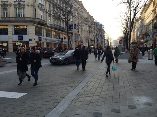
  • Don’t forget that this is about people

    Yesterday I wrote about the High Line Park in New York and the tremendous success that it has seen since the first section opened in 2009. It attracts somewhere around 5 million visitors a year and is thought to be responsible for over $2 billion a year in economic activity.

    But the economic activity it’s generating and the future tax revenues it’s creating are really a byproduct of the fact that people, quite simply, love the High Line. It attracts people. And that reminded me of a short post I wrote earlier this year called: It’s all about people. Because if you think about it, that’s really the key metric for a lot of things in life and in business.

    When you build a park like the High Line in New York or Millennium Park in Chicago, you’re designing it to attract people. When you build a mall, you seek out anchor tenants, because you know they drive foot traffic. When you build a new neighborhood, you’re trying to create street life from scratch. When you run a bar, you want headcount. And when you build a web or mobile app (or write a blog for that matter), you want registered users and eyeballs on your platform.

    And you want these things because foot traffic, street life, eyeballs, impressions, users, and headcounts ultimately generate revenue. But here’s the thing: if you focus directly or too much on that end goal, you run the risk of missing an important step along the way, which is simply to delight real people.

    In his most recent essay, startup guru Paul Graham put it perfectly when he said:

    “The way to succeed in a startup is not to be an expert on startups, but to be an expert on your users and the problem you’re solving for them.

    He’s obviously talking about technology products, but the same could be said for parks, streets, malls, plazas, and so on. To design and build better cities, we need to be experts on people. And we need to create spaces and environments that people actually want to occupy. Spaces that improve people’s lives.

    Now, this may sound fairly obvious to some of you. But quite often I feel like we get sidetracked by things that don’t matter as much as people do.

    Image: Flickr

  • Dimensioning pedestrian happiness

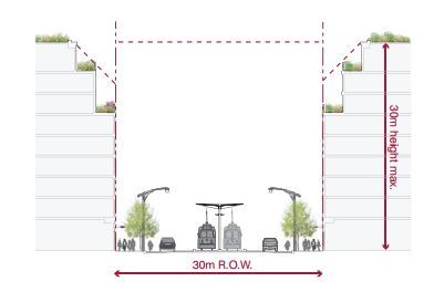
    The area that stretches between the property line on one side of a street and the property line on the other side of a street is called a public right-of-way here in Toronto. It may be called something different in other cities and countries.

    In the example below (taken from Toronto’s Avenues & Mid-Rise Buildings Study), it includes the sidewalks, the car lanes, and the streetcar lanes. But it could also include other public elements. In this instance, the buildings on either side of the street are assumed to be built right up against their property lines.

    ROWs obviously serve an important public function. But their size also has important urban design implications. As a pedestrian, it feels different to walk on a narrow street than it does on a broad street.

    The width of a ROW can also be used to inform what the preferred height of the buildings along it should be. In the example above, they’re talking about a 1:1 relationship between the width of the ROW and the preferred height of the buildings.

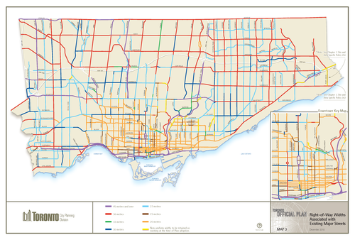
    Given their importance, I thought it would be interesting to share this map of Toronto (dated 2010) showing ROW sizing throughout the city. The mustard colored lines in the core of the city represent 20 metres, the red lines 36 metres, and the purple lines 45 metres or more. The rest of the colors fall somewhere in-between. For the most part, the purple lines represent highways, although there are a few other instances of purple.

    What’s interesting – but not surprising – to see is how we basically kept expanding the size of our ROWs as Toronto grew outwards. This was obviously to make more room for cars on the road.

    But the other, perhaps more interesting thing about this map, is that it could also serve as a guide to pedestrian happiness. The mustard/yellow lines are where it’s most enjoyable to walk. And the red and purple lines are where it’s least enjoyable to walk.

    If you’re from Toronto, give this framework a try and see if it holds true.

  • How are you being shaped?

    image

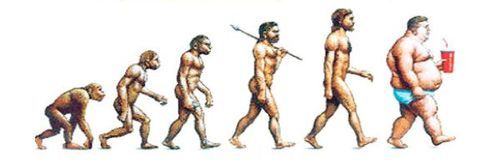
    “We shape the cities, and then our cities shape us.” That’s one of my favorite lines from the documentary The Human Scale, featuring Danish architect and urban designer Jan Gehl. I like it because I don’t think many of us think enough about the way in which the built environment – that we create – ultimately goes on to influence the way we live our lives.

    One of the most interesting connections for me is the link between urban form and public health. There’s been a lot of talk over the years about how suburban sprawl is, or might be, making us fat (among other things). We’ve created environments that are only navigable by cars and that has forced many of us into sedentary lifestyles. We sit in our cars, and then we sit in our offices.

    So today I’d like to conduct a bit of a poll. If you’d like to participate, please share the following 3 things in the comment section below: 1) your city, 2) the type of neighborhood you live in (urban, suburban, rural, etc.), and 3) the amount of time you spend walking or doing something active on an average day.

    Here’s me:

    I live downtown Toronto in the St. Lawrence Market neighborhood (urban). I take the subway to work and the station is a 10 minute walk from my place. So as a bare minimum, I spend at least 20 minutes a day walking. But since I also walk to do most of my regular errands, and since my gym is another 10 minute walk from my place, I’d say I average a good 30-45 minutes of walking each day.

    Now it’s your turn 🙂

    This is a pretty crude survey, but with the advent of things like smartwatches and health monitors, I think we’ll soon have lots of great data on the ways in which our cities might shape our health.

    Image: The Economist

  • Learning from Melbourne

    Earlier this week my good friend Gabriel Fain emailed me a bunch of photos from his recent trip to Melbourne. Gabriel and I went to architecture school together here in Toronto and we often go back and forth on city building issues.

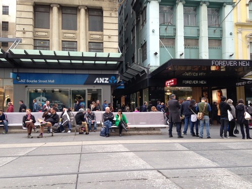
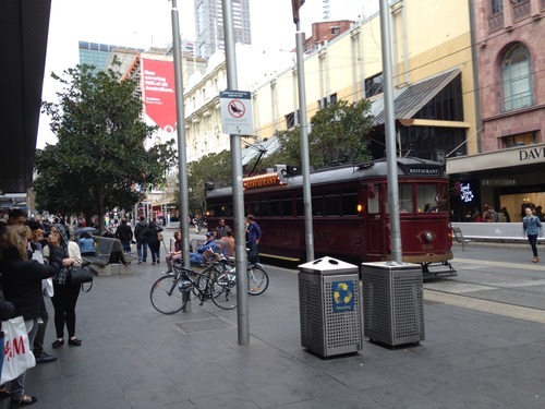
    Here are the photos he sent me of Bourke Street in Melbourne:

    image

    image

    The comparison he drew in his email was to that of Bloor Street in Toronto, except with a few major differences: Bourke Street is pedestrian only (except for a tram running down the middle of it). It has no curbs. There’s lots of inviting seating. And the connecting cross street laneways are fully activated. He then ended by saying that "Toronto is light years behind Melbourne and Sydney in the terms of the quality of the public space.“ 

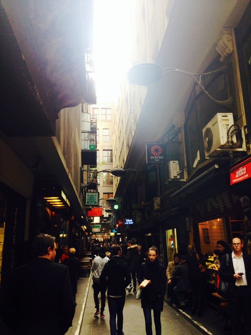
    I replied and asked if I could turn his email into an ATC post. He responded by saying that he was hoping I would, and then sent me another photo – this time of one of the laneways:

    image

    Melbourne’s laneways and arcades are celebrated around the world. What was once just residual space, became a catalyst for the revitalization of the city’s central business district in the 1990s and a major tourist destination. But all it really took was a change in thinking. It took somebody to believe that the space used for garbage collection, could also be used for a thriving culture of intimate al fresco dining.

    In Toronto, I think we’re headed in the right direction in terms of our thinking, but that we’re not yet being bold enough. The recent revitalization of Market Street in my neighborhood (St. Lawrence) is a wonderful example of putting pedestrians first and a wonderful street overall. Like Bourke Street, it also doesn’t have curbs (this is how you know pedestrians matter). But it was also a prime candidate for a pedestrian-only street. Especially given that Market Lane to the north is already one (though in desperate need of renewal). 

    For a number of reasons though, pedestrian-only streets are difficult to accept here in Toronto. I’ve been shot down many times in real estate meetings for arguing that we should have them in our city. Oftentimes people say it’s because of our harsh climate. But in my view, that’s all the more reason to have them. When the weather is nice, we should be enjoying our public spaces to the fullest. Why only build to the worst case scenario? Plus, they work in Scandinavia.

    We’ve also done it before. In the early 1970s (when I wasn’t around), a portion of Yonge Street was piloted as a pedestrian-only mall – a remarkably forward-thinking achievement for that era of city building. So I’m confident that it can be done and that we’ll one day do it again.

  • Cawthra Park revitalization

    I must have been living under a rock because I just discovered this weekend that Toronto is in the midst of hosting WorldPride. I obviously knew that it was Pride Week, but I didn’t realize that we had outbid Stockholm in 2009 in order to be awarded the event. 

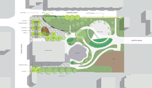
    I also didn’t realize that Cawthra Park near Church Street & Wellesley Street was being revitalized in preparation for both WorldPride 2014 and for the Pan Am & Parapan American Games in 2015 – which Toronto will also be hosting.

    Here’s a site plan of the final design:

    image

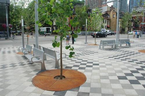
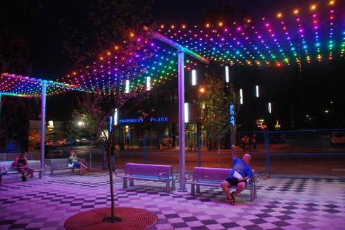
    And here’s what the completed design looks like:

    image

    image

    I like the pavers and I like the overhead LED lights. Those may not seem like big additions, but it’s amazing how those small little details can impact the way a space feels. I think it creates an intimate and inviting space. What do you think?

    Images: thinc design

  • We want what we want

    This past Sunday night I was out for a bike ride with a few friends all around downtown Toronto. According to Strava, we did almost 22 km. Click here to see our route. During the ride, one of my friends said something to me that stood out. He said that when he’s on a bike he wants all cars off the road; but when he’s in a car, he wants all bikes off the road.

    Now, this may seem like a fairly banal statement, but I think it demonstrates a number of things about people and the way we interact with cities. First, we’re all probably pretty selfish. We want what we want at a specific moment in time and we easily forget what it’s like to be on the other side of a situation.

    Second, I think it reinforces what I wrote a month ago in a post called: Every street can’t be everything to everyone. If we want to improve the user experience for a variety of different use cases (driving, biking, walking and so on), we should decide when and where we’re going to optimize for each. 

    The reason my friend said what he said was because we were riding on a road with no bike lanes. We were swerving in and around cars. And when the street is shared like this it naturally becomes a competition of who can be the most aggressive and dominate the road–bikes or cars. But as exciting as that might be, it’s probably not an ideal way to build our cities.

  • The Human Scale

    Earlier today I stumbled upon a documentary called “The Human Scale.”  I haven’t watched it yet, but I’m planning to rent it from iTunes later this weekend. Here’s the trailer. Click here if you can’t see it below.

    [youtube https://www.youtube.com/watch?v=5CyLNS_ljHw]

    One of the things that’s so fascinating about studying cities right now, is that it feels as if we’re at a major turning point with respect to how we think about them. We’re coming off a long period (decades) of infatuation with the car, where planners and engineers predominately cared about one thing and one thing only: efficiently moving cars in and around cities.

    But having now fully built out cities around the car, we’ve come to realize two important things. First, that it’s virtually impossible to keep up with the demands of the car. No matter how many highways and roads you build, there always seems to be gridlock. And second, by focusing so closely on the car, we’ve built cities that aren’t great places for people.

    If you take a look at this short clip from The Human Scale (featuring Siena, Italy), I think you’ll immediately see how differently we used to build our cities and how disruptive the car has been to them.