Daily insights for city builders, delivered every morning at 6 AM ET. I’m Brandon Donnelly — a Toronto-based real estate developer and founder of Globizen. I’ve been writing here since 2013.

Tag: ttc

  • The Ontario Line is happening

    Yesterday afternoon, I took the 504 King streetcar from the Bloor-Dundas West mobility hub down to King & Bathurst to meet a friend at the Wheat Sheaf Tavern. In case you didn’t know, this is believed to be the oldest continually-operating pub in the city. It opened in 1849.

    My streetcar ride took an obscenely long time (over an hour) and so it was the wrong mobility choice for a peak summer afternoon. I should have biked. But once I did finally arrive at Toronto’s oldest pub, it was great to see all of the activity happening right at the intersection for the new King-Bathurst subway station (Ontario Line).

    I’m always a bit cynical when it comes to transit plans. Like, it’s hard for me to believe that something is actually happening. I’m still waiting for SmartTrack to open. So I need constant visual reminders like these:

    What you are seeing above is the northeast corner of the intersection, which is where one of the two station entrances will go. Naturally, the station platform and track itself are also aligned on a diagonal so as to minimize “significant construction impacts” to the Wheat Sheaf (southwest corner).

    This stop is also one of Infrastructure Ontario’s Transit-Oriented Communities, which means the intent is to have a private developer build things on top of the station. Directionally, this is, of course, the right approach. It didn’t happen on the Eglinton Crosstown line; but we know that the best way to maximize the value of transit investment is to combine it with smart land use planning (the rail + property model). Density is your friend.
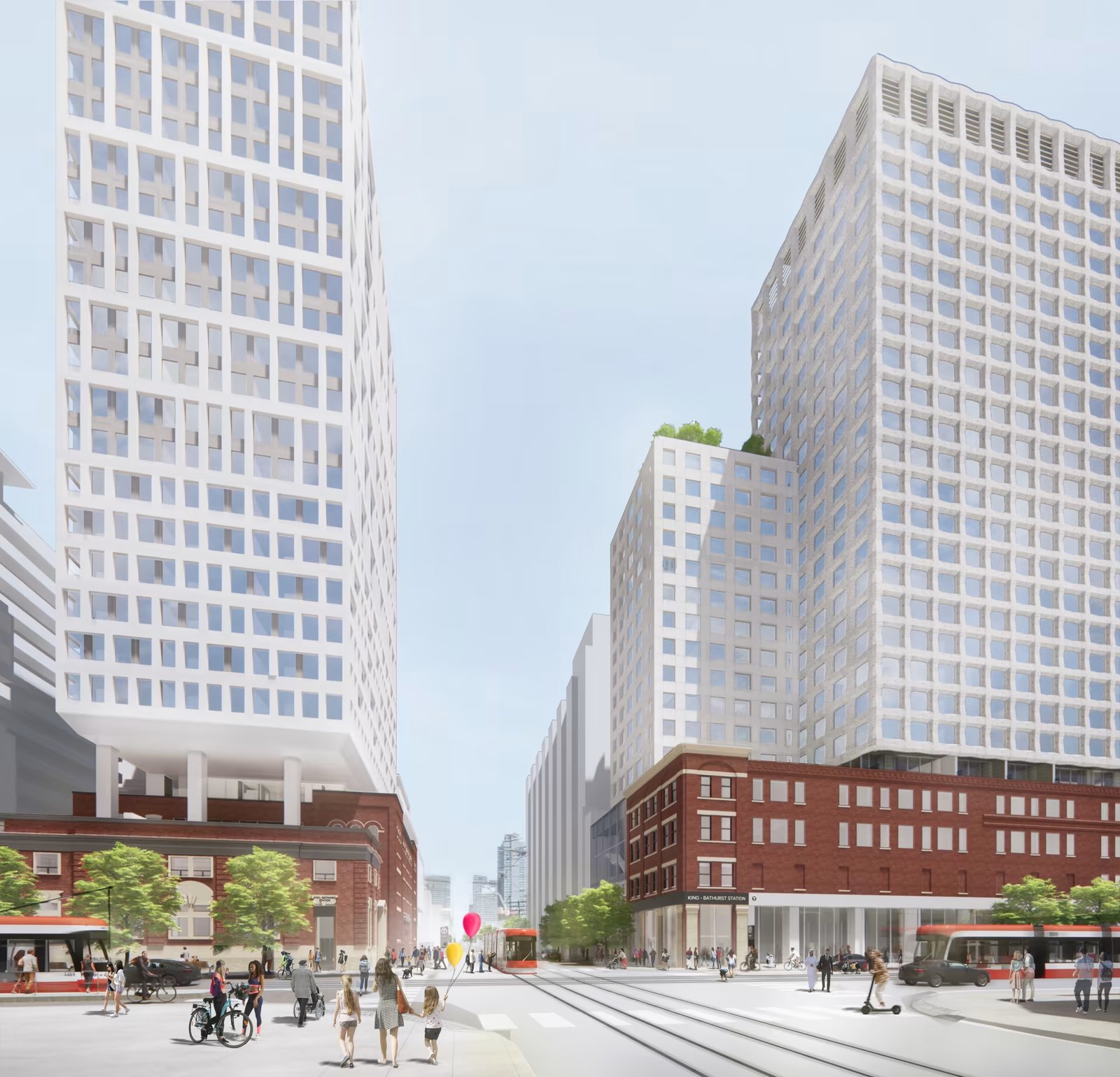
    From what I could glean during my time on the patio at the Wheat Sheaf, all of this appears to be moving forward. And already today, there is a ton of foot traffic in the area — meaning the future transit station should do very well from a ridership perspective. Now we just need this line extended up to the Bloor-Dundas West mobility hub so that the 504 streetcar can be relieved of some of its duties.

    Station Plan/Rendering: Metrolinx and IO

  • Line 1 to dinner

    On most days, I walk to the office. That is going to be changing later this summer, but what I’m about to say will still apply.

    Because I walk more often than I drive, whenever I have to go somewhere that necessitates a car and that obligates me to leave during the evening rush, the first thing I usually think to myself is “shit, it’s going to really suck getting out of downtown.”

    I have very little patience when it comes to sitting in traffic. So when I’m faced with this kind of situation, my mind immediately goes to: “okay Brandon, what are your other options here?”

    And this is exactly what happened this past Friday. I had a dinner up in Vaughan after work and I opted to take the subway to VMC station (the northern terminus of one of Toronto’s lines).

    It was actually my first time riding this new line extension and it was cool to see the area around the station. It’s not yet a 15-minute community, but I believe it can get there with some narrow streets and the right kind of ground floors.

    The entire trip took about 45 minutes, and I can tell you that on more than one occasion I thought to myself, “this is way better than sitting in traffic.”

  • New York City rolls out contactless fare payment at every single subway station

    I’m late to the party here, but I was reading this morning about how New York City recently completed the rollout of its One Metro New York (OMNY) fare payment system. What this does is allow you to use contactless payment systems, like Apple Pay, to get on the subway. ONMY is now available across the five boroughs on every bus and at all 472 subway stations (feel free to impress your friends at virtual parties with this stat).

    Metrolinx here in Toronto is similarly piloting contactless payments on the Union Pearson Express. You now have the option of tapping a credit card, a phone, or a watch. Maybe this doesn’t seem like such a big deal, but I still remember when the PRESTO payment card was first rolled out — it felt late to me. Apple added near-field communication (NFC) to iPhone in 2014, and at that point I think it was fairly obvious that standalone payment cards wouldn’t be around much longer.

    That time has arrived for New York City and will be hopefully arriving shortly for Toronto. And I think it will be particularly useful for tourists who may not have a Metrocard (NYC) or PRESTO card (Toronto) and just want to jump on a train. I’ve only taken the subway a handful of times during this pandemic, but I’ll be back at it once the world fully resumes. And I definitely can’t wait to take the UP Express to the airport again (and to the Junction).

  • Transit advertising according to the numbers

    This morning I saw this tweet about Toronto streetcar advertising. The author has a “big problem” with public transit being fully wrapped in ads and so she decided to tweet her local Councillor to see if these could be somehow limited in size.

    My first thought was: I wonder how many people would accept higher fares in exchange for fewer/no advertising. Is this something people care about? Because personally, I’ll take the lower fares in exchange for someone trying to monetize my attention. I mean, every social network I use is already selling my attention off as their product.

    But then this got me thinking about what the actual numbers look like. So let’s look at some of those for not only Toronto, but also for Hong Kong, since many people view that as the gold standard as far transit authorities go.

    For the year ending December 31, 2016, the Toronto Transit Commission (TTC) posted a total operating revenue of $1.204 billion. This represents about 41% of total revenue – the rest comes from subsidies.

    If you drill down into operating revenue, advertising makes up $28 million or about 2.33% of total operating revenue. So a pretty small number. If you tried to shift this number over to “passenger services” revenue (transit fares), it actually wouldn’t increase fares by that much. But presumably fares are already at some profit maximizing number.

    Switching to Hong Kong’s MTR Corporation, their numbers have to be unpacked a little differently because the group has a number of diverse business lines, including property development.

    For the year ending December 31, 2016, total revenue from Hong Kong Transport Operations was HK$17.655 billion (almost all fare revenue). Advertising falls within the Hong Kong Station Commercial Businesses group and that company posted revenues of HK$5.544 billion for the same time period.

    To try and create some sort of comparison, I’m ignoring all of the other segments within MTR.

    Within Station Commercial Businesses, advertising revenue alone makes up HK$1.09 billion or about 20% of that group’s total revenue. The rest comes from station retail rent (the biggest chunk), telecom, and some miscellaneous station income. 

    If you add up Transport Operations and Station Commercial Businesses, total revenue was HK$23,199 billion for the year ending 2016. Advertising comprises about 4.70% of this – so more than double that of Toronto.

    It’s also worth noting that MTR’s station retail rental revenue is about 3.4x that of its advertising revenue. In the case of Toronto, the TTC actually makes more money off advertising than it does from “Property Rental.” I’ve always thought this was a missed opportunity. Transit and land use go hand in hand.

    In any event, I’m far less fussed about advertising on transit. But what are your thoughts? Let me know in the comment section below.

    Photo by Tomo Nogi on Unsplash

  • Uberpooling your way to cheap rides

    This morning on my way into the office I ran into a friend who lives in my building (downtown). She works in midtown and so I asked her how she gets into the office. She told me that she either takes the subway or an Uber, but that increasingly she has been taking Uber, particularly on the way home.

    We then started talking costs and she told me that what she does is carpool with a friend from work using UberPOOL. They live nearby and so what they do is leave from the same place at night (the office) and then select a midpoint location between their homes for the drop-off. After splitting their portion of the fare, the ride costs her about $3.25.

    As she was telling me this, I couldn’t help but think to myself: Wow, this is massively disruptive to transit. That is the same cost as taking the subway. So why take transit? With the subway, there may be a speed argument in certain instances, but that certainly wouldn’t be the case with some of Toronto’s streetcar lines (such as the King line). It’s faster to walk.

    However, there are obviously geographic limits to how far you can go in an UberPOOL before your costs greatly exceed taking transit. But as Uber and other similar services continue to bring down the price of a ride (eventually the labor cost component will disappear), how big does that area get?

    All of this – including my own mobility patterns – has got me thinking yet again about the role of transit in the city of tomorrow. 

    One segment that continues to be underserved is the regional scale. Here in the Greater Toronto Area, we are working on that by transforming our commuter rail service into a two-way all-day Regional Express Rail service. Today that strikes me as being hugely valuable. And unless driverless vehicles somehow solve our traffic problem, it will likely remain that way.

    I would love to get your thoughts in the comments below.

  • Towards a cashless society

    I increasingly never carry cash on me. I just never think to take out money and, when I do, I hate paying for things and getting change back. That change just ends up in a “change jar” in my apartment and then never comes out ever again. I keep telling myself that I need to buy coin rolls but that never seems to happen.

    Lucky for me, it’s pretty clear that many cities and countries are quickly headed towards a cashless society. It’s pretty easy to get by in most cities today without cash. Here in Toronto, I use Uber and my PRESTO card to get around. I can use my phone for many purchases like coffee. And I can use my credit/debit cards for everything else. I never really thought about it until recently, but I have unintentionally gone almost completely cashless.

    But of course it’s not just cash that is going to disappear; it’s also our physical wallets. Just this week Fred Wilson wrote a post on his blog about how he forgot his wallet at home and how Apple Pay came to the rescue at Whole Foods. I can’t wait until more banks roll this out in Canada. It’s also encouraging to see that under “coming soon” on the Apple Pay website, the Toronto Transit Commission is listed. I guess that means it will be integrated with PRESTO.

    However, this transition is not happening in the same way everywhere. There are many countries that still prefer cash. According to CNN (November 2015), only about 10% of people in Indonesia and the Philippines would prefer to pay with a credit card. And it’s for this reason that Uber now accepts cash in a number of countries. It’s what those customers wanted. I find this interesting though, because not having to carry cash is one of the main reasons I use Uber.

    Of course, there’s also the question of what happens to people who are currently not connected in anyway to electronic forms of money. I get asked by people on the street for change at least every day when I walk around Toronto. But there is actually no way for me to transmit the money I have to them. I don’t carry cash and I certainly don’t carry change.

    I would be curious how many of you have gone or are close to going cashless. And if you are operating cashless, did you even notice the transition happening?

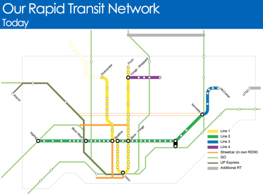
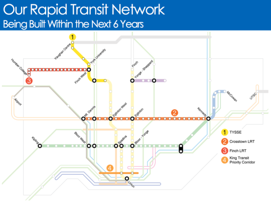
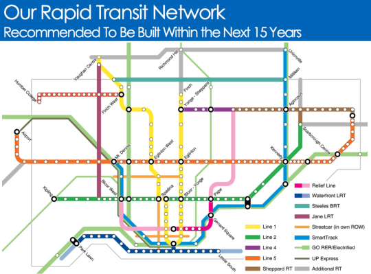
  • Toronto’s rapid transit network by 2031

    Starting today and running until the end of March, the City of Toronto, the Toronto Transit Commission, and Metrolinx will be hosting several public meetings as they work towards planning out this city and region’s rapid transit network.

    Below are a few of the key maps from their presentation.

    Here is what Toronto’s rapid transit network looks like today (the hollow lines represent projects in construction):

    image

    Here is what will be built within the next 6 years:

    image

    And here is what they are recommending should be built within the next 15 years:

    image

    It’s hard not to get excited when you see maps like this. Of course, it’s a lot easier to draw lines on a map then it is to fund and execute on projects like this.

    But I think it all starts with us acknowledging that these initiatives are critical to both our economic competitiveness as a city region and our quality of life as citizens of it. Because if this is something we really want, then we can absolutely make it happen.

    Click here if you’d like to see the full presentation and also the public meeting dates/times.

  • Bringing public transit into the 21st century

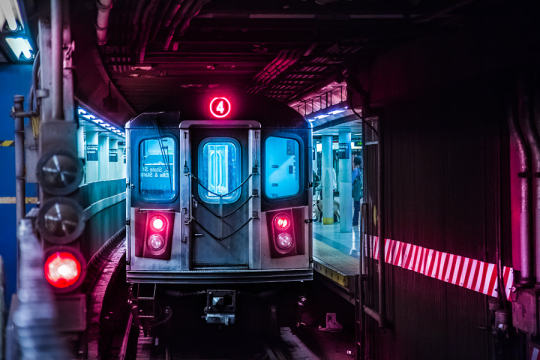
    New York Subway by Lok Yiu Cheung on 500px.com

    https://500px.com/embed.js

    I think we’ve hit peak millennial.

    Last Friday the Governor of New York, Andrew Cuomo, and the Metropolitan Transit Authority, announced that 30 subway stations will be redesigned and that “millennial-friendly amenities” would be added throughout the system

    As you might guess, this includes adding phone chargers in train cars and buses and wifi throughout all the stations (by the end 2016). They will also be replacing the MetroCard with an all digital fare system that will include mobile payments.

    But the reality is that this isn’t about being millennial-friendly. This is about joining the 21st century.

    Here in Toronto, we finally have our PRESTO card working on all streetcars and in almost 40% of the city’s subway stations. This is a huge improvement over our laughable and antiquated token system, but it’s not enough. I really hope the next rollout is a mobile app that will allow everyone to pay with just their phone.

    We also have wifi in about 30% of our subway stations, but again this is not enough. By the time you get authenticated (do you need to have Twitter now?), your train is usually arriving and then you enter a tunnel where no wifi exists. We need to be looking at the entire tunnel network. (Related topic: LinkNYC

    I say all this because I am a big supporter of public transit. Despite all the positive things I write about Uber, ridesharing, and driverless cars, I do not believe that they will eradicate the need for a strong transit backbone. This is fundamental to our city building efforts. 

    So let’s do our best to delight people when they take transit.

  • Riding the new streetcar

    image

    This afternoon I rode Toronto’s new streetcar for the first time on my way home from Chinatown. I had been meaning to do it for weeks now, but this was my first opportunity.

    The experience was infinitely better than what you get today on our current streetcars. I felt like I was in a new city. The proof-of-payment system makes onboarding much faster and the 4 loading doors means you just get on the train where there’s the most room – instead of getting on at the front and fighting your way to the back.

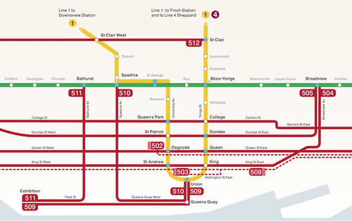
    The other thing I liked is that they now have a map of our streetcar network within the train (see above image). Toronto never used to do this. For whatever reason, we didn’t like mixing subway lines with streetcar lines on the same map. 

    But why be so pedantic?

    For one thing, our subway map looks pathetic without these additional streetcar lines on it. So for the sake of Torontonian morale, please fill it up with what you can.

    But the other reason why I think it’s important to include them is that we shouldn’t be thinking about our cities just in terms of specific technologies (subway, streetcar, and so on). Our cities are now multi-modal. Which means we navigate them using many different means, from subways and streetcars to bikes and Uber cars. What people care about is getting from A to B in the most efficient and enjoyable way possible.

    This may seem like a subtle distinction, but it’s an important one. And maybe, just maybe, these new maps will serve as an important reminder to us that there’s a lot of fixed rail in this city and that it could be far better optimized if we just tried a little harder.

  • Understanding the radius of demand for transit

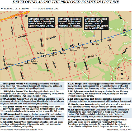
    Last week The National Post published an article talking about Toronto’s Crosstown LRT and how it’s spurring a wave of development all along Eglinton Avenue. Below is a map, taken from that article, showcasing some of the developments that are currently in the pipeline and awaiting the Crosstown’s opening date of 2020.

    image

    Not surprisingly, developers like transit investment. But more specifically, they like fixed track transit investment. Rarely do new bus routes elicit the same sort of response that you’re seeing above. And that’s because fixed track investment has permanence. If you’re going to go long on an area, you want certainty.

    As the Crosstown tunnel boring machines move across midtown Toronto, I thought it would be interesting to look at a transit concept that I first learned about through Jarrett Walker’s Human Transit blog. It’s called: the radius of demand

    One of things that transportation planners look at when designing and building a new line is the spacing of stops. Typically, as you move from buses all the way up to subways, the spacing between stops and stations increases. Spacing is always a bit of a trade off though, because more stops means easier access for riders, but it also means slower overall service. Somewhat famously, Paris designed its metro system so that you’re rarely more than 500 meters away from a station. 

    Once you have your station locations, it’s quite common to then draw a radius around each stop to simulate the catchment area. In other words: How much of the city can I service with this station and how far will people be willing to walk in order to get there? However, this distance, which is the radius of the circle, usually depends on the type of transit. Oftentimes people are willing to walk further in order to get to faster transit service.

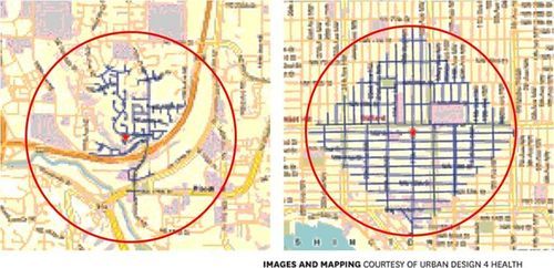
    But what’s most interesting about this radius of demand is that it’s entirely dependent on the fabric of the city. Take for example, the following two maps from Seattle, which I have taken from Walker’s blog. On the left is a suburban setting and on the right is a downtown setting. In both cases, the red circle represents a 1 km radius.

    image

    Now, if humans could fly over barriers, such as highways, and every Seattle resident was willing to fly exactly 1 km to a transit station, these two radiuses of demand would be perfectly accurate. But since that’s not the case, we instead need to look at what actually represents a 1 km walk – those are the blue lines in each image.

    Because once you do that, you realize that the cul-de-sacs and highways on the left make it impossible for most of that radius of demand to actually walk to the station in under 1 km. So the catchment area actually becomes much smaller. On the other hand, if you look at the image on the right, you’ll see that the tried and true city grid is actually remarkably efficient for walking. Almost all of the circle is serviced.

    So as the Eglinton Crosstown LRT makes its way through the center of Toronto, I think it’s important to keep in mind that it’ll be cutting through quite a few different kinds of street grids. Some of them will be highly conducive to transit usage and others not as much. And in many ways, this is one of the greatest challenges of transit investment. The track itself is only one part of the puzzle.

    That’s why the City of Toronto is also undertaking a planning exercise called Eglinton Connects. Its intent is to leverage the opportunities, as well as address the challenges, that will result from Metrolinx’s Crosstown LRT. If you’re interested in the future of Eglinton Avenue, you should consider getting involved. Oftentimes it’s only the critics that speak up. But that’s not the best way to build anything.